Who What Where WhenREMOVE |
Author
Tanner, Henry S.
Full Title
Brittannicae Insule ex Aevi Romani Monumentis. Published by H.S. Tanner, Philadelphia. (1826)
Publisher
H.S. Tanner
Full Title
Ireland in provinces and counties. County map of Scotland. (with) Shetland Islands. Copyright 1886 by Wm. M. Bradley & Bro.
Publisher
Wm. M. Bradley & Bro.
Author
Rand McNally and Company
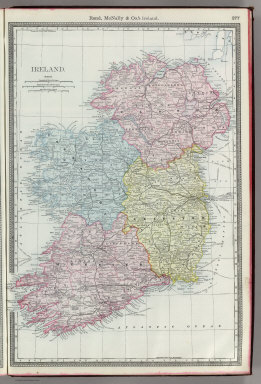
Full Title
Rand, McNally & Co.'s Ireland.
Publisher
Rand McNally
Author
[Lowry, J.W., Sharpe, J.]
Full Title
Sharpe's Corresponding Maps. Great Britain and Ireland. Engraved by J. Wilson Lowry. London - Published by Chapman and Hall, 186 Strand, 1847. Divisional Series.
Publisher
Chapman & Hall
Author
[Lowry, J.W., Sharpe, J.]
Full Title
Sharpe's Corresponding Maps. Ireland. London - Published by Chapman and Hall, 186 Strand, 1847. Enlarged Series.
Publisher
Chapman & Hall
Author
[Black, Adam & Charles, Hall, Sidney, Hughes, William]
Full Title
Ireland. Edinburgh. Published by A. & C. Black. Engraved by S. Hall, Bury Strt. Bloombry.
Publisher
Adam & Charles Black
Author
[Black, Adam & Charles, Hall, Sidney, Hughes, William]
Full Title
Ireland. Edinburgh. Published by A. & C. Black. Engraved by S. Hall, Bury Strt. Bloombry.
Publisher
Adam & Charles Black
Author
Johnston, W. & A.K.
Full Title
The British Isles (Political). (with) Shetland Islands. (with) Channel Islands. (with) London Metropolitan Boroughs. Keith Johnston's General Atlas. May 1911. Engraved, Printed, and Published by W. & A.K. Johnston, Limited, Edinburgh & London.
Publisher
W.& A.K. Johnston
Author
Johnston, W. & A.K.
Full Title
Ireland. (with) Dublin. Keith Johnston's General Atlas. Feb. 1911. Engraved, Printed, and Published by W. & A.K. Johnston, Limited, Edinburgh & London.
Publisher
W.& A.K. Johnston
Author
[Martin, R.M., Tallis, J. & F.]
Full Title
Ireland. The Illustrations by J. Marchant & Engraved by J. Rogers. The Map Drawn & Engraved by J. Rapkin.
Publisher
J. & F. Tallis
Author
Finley, Anthony
Full Title
Ireland. Young & Delleker Sc. Published by A. Finley Philada.
Publisher
Anthony Finley
Author
Johnson, A.J.
Full Title
Johnson's Ireland. Published by Alvin J. Johnson & Co., New York. Johnson's Scotland. Published by A. J. Johnson, New York. 91. 92. Entered according to the Act of Congress, in the year 1867, by A.J. Johnson in the Clerk's Office of the District Court of the United States for the Southern District of New York.
Publisher
Alvin J. Johnson & Co.
Author
Carey, Mathew
Full Title
Ireland as Represented in the Imperial Parliament. J. Bower. Sc.
Publisher
M. Carey and Son
Author
Mitchell, Samuel Augustus
Full Title
County Map Of Scotland. 63. (with) inset map Shetland Islands. 64. (and) Ireland In Provinces And Counties. 65. Entered ... 1860, by S. Augustus Mitchell, Jr. ... Pennsylvania.
Publisher
S.A. Mitchell, Jr.
Author
Gray, Ormando Willis
Full Title
British Isles. (inset) The Orkney and Shetland Islands.
Publisher
O.W. Gray & Son
Author
USSR (Union of Soviet Socialist Republics).
Full Title
58-59. Great Britain and Ireland. The World Atlas.
Publisher
USSR
Author
Jouvet et Cie.
Full Title
Isles Britanniques. Atlas St. Cyr. G. Hue. Furne, Jouvet et Cie. editeurs. Paris. Imp Monrocq. La Lettre gravee par J. Geisendorfer, 12 r. de l'Abbaye, Paris. (1882)
Publisher
Jouvet et Cie
Author
[Robert de Vaugondy, Didier, 1723-1786, Robert de Vaugondy, Gilles, 1688-1766, Sanson, Nicolas, 1600-1667]
Full Title
Britannicae Insulae in quibus Albion seu Britannia Major, et Ivernia seu Britannia Minor, juxta Ptolemoei mentem divisae, tum in suas majores partes, tum in populos exhibentur, a Nicolao Sanson, Christ. Regis Geographo, Revisae, et ad Observationes astronomicas redactae, accurante Robert de Vaugondy filio, Cum Privilegio Regis, 1750. Guill? Delahaye sculpsit.
Publisher
[Boudet, Les Auteurs]
Author
Robert de Vaugondy, Gilles, 1688-1766
Full Title
Les Isles Britanniques qui comprennent les Royaumes d'Angleterre, d'Ecosse et d'Irlande; par le Sr. Robert Geographe Ordinaire du Roi. Avec Privilege, 1754. Grave par E. Dussy. (Elisabeth?) Haussard Sc. (with inset) Supplement pour les Isles Orcades, Schetland, et Fero.
Publisher
[Boudet, Les Auteurs]
Author
Robert de Vaugondy, Gilles, 1688-1766
Full Title
Royaume d'Irlande divise en ses quatre Provinces, et subdivise en Comtes. Par le Sr. Robert Geographe ordinaire du Roy. Avec Privilege, 1750. Guill? Delahaye Sculpsit.
Publisher
[Boudet, Les Auteurs]
Author
Robert de Vaugondy, Gilles, 1688-1766
Full Title
Carte des grandes routes d'Angleterre, d'Ecosse, et d'Irlande. Par le Sr. Robert Geog? ordin? du Roy. Avec Privilege. 1757. Mre. Cne. (i.e., Marie Catherine) Haussard sculp.
Publisher
[Boudet, Les Auteurs]
|