Who What Where WhenREMOVEWHATShow MoreWHO
WHEN
|
Author
[Howe, Samuel Gridley, Ruggles, Samuel P.]
Full Title
Virginia and Maryland
Publisher
New England Institution for the Education of the Blind
Author
Cram, George Franklin
Full Title
(Covers to) Cram's Railroad & County Map Of Virginia, W. Virginia, Maryland & Delaware. Published By Geo. F. Cram. Proprietor Of The Western Map Depot. 262-264 Wabash, Ave. Chicago, Ills. 1881. Entered ... 1878, by G.F. Cram... Washington D.C.
Publisher
George F. Cram
Author
Cram, George Franklin
Full Title
Cram's Railroad & County Map Of Virginia, W. Virginia, Maryland & Delaware. Published By Geo. F. Cram. Proprietor Of The Western Map Depot. 262-264 Wabash, Ave. Chicago, Ills. 1881. Entered ... 1878, by G.F. Cram... Washington D.C.
Publisher
George F. Cram
Author
[U.S. War Department, Weyss, John E.]
Full Title
Antietam. Prepared by Bvt. Brig. Gen N. Michler, Major of Engineers from Surveys under his direction by order of Brig. Genl. & Bvt. Maj. Genl. A.A. Humphreys, Chief of Engineers and under the Authority of the Hon. Secretary of War. 1867. Surveyed & drawn by Maj. J.E. Weyss, assisted by F. Theilkuhl, J. Strasser & G. Thompson. Photolith. by the N.Y. Lithographing, Engraving & Printing Co., Julius Bien, Supt. (under War Department Seal) 1869.
Publisher
N.Y. Lithographing, Engraving & Printing Co.
Author
Johnson, A.J.
Full Title
Johnson's Delaware and Maryland. (inset) District of Columbia. Entered ... 1868.
Publisher
A.J. Johnson
Author
Johnson, A.J.
Full Title
Johnson's Virginia, Delaware, Maryland & West Virginia. Entered ... 1864.
Publisher
A.J. Johnson
Author
Meyer, Joseph, 1796-1856
Full Title
Neueste Karte von Maryland und Delaware mit seinen Canaelen, Strassen und Entfernungen der Hauptpunkte. 1846. (with) Grundriss von Baltimore. Aus der Graviranstalt des Bibliographischen Instituts zu Hildburghausen, Amsterdam, Paris u. Philadelphia, (1860)
Publisher
Bibliographischen Instituts
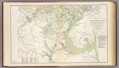
Author
[Hesselbach, W., U.S. War Department, Topographical Engineers, United States. War Department, Young, J. J.]
Full Title
Surveys for military defenses. Map of northeastern Virginia and vicinity of Washington. Sheet 1. Compiled in Topographical Engineers Office at division headquarters of General Irvin McDowell, Arlington, January 1, 1862. Corrected from recent surveys and reconnaissances under direction of the Bureau of Topographical Engineers, August 1, 1862. Drawn by J.J. Young and W. Hesselbach. Julius Bien & Co., Lith., N.Y. (1891-1895)
Publisher
U.S. Government Printing Office
Author
[Hesselbach, W., U.S. War Department, Topographical Engineers, United States. War Department, Young, J. J.]
Full Title
Surveys for military defenses. Map of northeastern Virginia and vicinity of Washington. Sheet 2. Compiled in Topographical Engineers Office at division headquarters of General Irvin McDowell, Arlington, January 1, 1862. Corrected from recent surveys and reconnaissances under direction of the Bureau of Topographical Engineers, August 1, 1862. Drawn by J.J. Young and W. Hesselbach. Julius Bien & Co., Lith., N.Y. (1891-1895)
Publisher
U.S. Government Printing Office
Author
U.S. War Department, Topographical Engineers
Full Title
Part of map of portions of the military departments of Washington, Pennsylvania, Annapolis and Northeastern Virginia. Compiled in the Bureau of Topographical Engrs., War Department &c., July 1861 ... report of Maj. Gen. Geo. B. McClellan ... and Maj. A.J. Myer ... Battle-fields of South Mountain showing the positions of the forces of the United States and of the enemy during the battle fought by the Army of the Potomac under the command of Maj. Gen. Geo. B. McClellan, Sept. 14, 1862. Prepared in the Bureau of Topographical Engineers. (with) Map accompanying Lieutenant General Pemberton's report of operations near Vicksburg, Miss., December 21, 1862, January 2, 1863. Surveyed and drawn by H.A. Pattison, Civil Engr. Julius Bien & Co., Lith., N.Y. (1891-1895)
Publisher
U.S. Government Printing Office
Author
[Bowen, Nicolas, United States. War Department]
Full Title
Map of the battle of the Antietam fought on the 16th and 17th September 1862 between the United States forces under the command of Maj. Gen. Geo. B. McClellan and the Confederates under Gen. Robert E. Lee. Prepared ... under the direction of 1st Lt. Nicholas Bowen ..., 1st Lt. A.H. Cushing ..., Chas. Shoemacker, E.F. Bowke, Jos. McMakin, C.A. Mallory, assts. ... October 1862. (with) Map of the battle of the Antietam ... sketched under the direction of Capt. J.C. Duane ... by Maj. D.C. Houston ..., Lt. N. Bowen, Lt. Js. H. Wilson, Lt. Jno. M. Wilson ..., Lt. W.A. Roebling ..., W.S. Long ..., Jos. McMackin ... (with) Engagement at deserted house or Kelly's Store near Suffolk, Va., January 30th 1863 (with) Battle-field of Gettysburg, July 1-4, 1863. Drawn by Thomas Peters ... (with) Map of the position of the cavalry during the engagement of April 4th 1863 ... (with) Map of that portion of the battle-field of Antietam occupied by the troops under Maj. Gen. Burnside ... from surveys made under the supervision of Capt. R.S. Williamson ... by H.C. Fillebrown, E.S. Waters, Civ. Eng'rs. Julius Bien & Co., Lith., N.Y. (1891-1895)
Publisher
U.S. Government Printing Office
Author
[Michler, Nathaniel, United States. War Department]
Full Title
Antietam. Prepared by Bvt. Brig. Gen. N. Michler, Major of Engineers from surveys under his direction ... 1867. Compiled and drawn by Maj. J.E. Weyss, assisted by F. Theilkuhl, J. Strasser and G. Thompson. ... Map of the battle-fields of Harper's Ferry and Sharpsburg with position of troops, routes of Army &c., Sept. 13 to 17, 1862 ... by S. Howell Brown, 1st. Lieut. Engr. Troops ... Jan. 27, 1864. To accompany report of General Robert E. Lee, C.S. Army. Julius Bien & Co., Lith., N.Y. (1891-1895)
Publisher
U.S. Government Printing Office
Author
United States. War Department
Full Title
Military map showing the topographical features of the country adjacent to Harper's Ferry, Va. including Maryland, Loudoun and Bolivar heights and portions of South and Short mountains with the positions of the defensive works, also the junction of the Potomac and Shenandoah rivers and their passage through the Blue Ridge. Surveyed from August 3d to Sept. 30th 1863 under the direction of Capt. N. Michler, Corps of Engrs., U.S. Army, by Major John E. Weyss ... Army of the Potomac. Map of the vicinity of Hagerstown, Funkstown, Williamsport and Falling Waters, Md. Accompanying the report of Major General G.G. Meade on the Battle of Gettysburg dated October 1st 1863. (with) Battle of Slaughter's Mountain, sketch of field August 9, 1862. (with) Sketch of that part of field at Cold Harbor where Ewell's Division operated, particularly where Trimble's Brigade fought, June 27, 1862. (with) Sketch of the battle-field of Cross Keys, Va., June 8, 1862. ... Julius Bien & Co., Lith., N.Y. (1891-1895)
Publisher
U.S. Government Printing Office
Author
[Confederate States of America. Army of Northern Virginia, Confederate States of America. Army, Hoffman, J. Paul, Hoffman, United States. War Department]
Full Title
Map of Orange County &c., Va. embracing the details and plan of operations of Confederate and Federal forces at Mine Run and Rapidan River by order of ... W.P. Smith, Lt., Col. of Engrs., Topl. Office, A.N.V. Prepared by J. Paul Hoffman. Accompanying report of General R.E. Lee, C.S. Army. (with) Part of map of portions of the military departments of Washington, Pennsylvania, Annapolis and Northeastern Virginia. Compiled in the Bureau of Topographical Engrs., War Department &c., 1861. Accompanying report of Capt. L.B. Norton ... (with Decatur, Howard's Plantation). From original in possession of Gen. W.T. Sherman. (with Brownings C.H.-Stone Mountain) C.B. Reese, Capt. Engrs. From original in possession of Gen W.T. Sherman. (with Campbellton Region) Accompanying letter of Maj. Gen. George Stoneman. (with) Map to show lines of march of Second Army Corps and the enemy, Oct. 14, 1863 ... report of ... G.K. Warren. (with) Map of battle-field at Bristoe fought by 2d Army Corps commanded by Maj. Gen. G.K. Warren, October 14, 1863. (with) Map of Missionary Ridge, Tenn. showing the positions attacked by the forces under the command of Maj. Gen. W.T. Sherman, Nov. 24th and 25th, 1863. Julius Bien & Co., Lith., N.Y. (1891-1895)
Publisher
U.S. Government Printing Office
Author
United States. War Department
Full Title
Map of Texas and part of New Mexico, compiled in the Bureau of Topographl. Engrs. chiefly for military purposes. Information on this map furnished by Wm. E. Young, C.E. and compiled under the direction of Maj. D.C. Houston, Chief Engr., Dept. of the Gulf. Accompanying letter of Gen. N.P. Banks ... (with) Plan of the battle-field at New Creek, W. Va., August 4th, 1864. (with) Plan of the battle-field at Pleasant Mills near Cumberland, Md., August 1st, 1864. Made by F.M. Knight. ... Julius Bien & Co., Lith., N.Y. (1891-1895)
Publisher
U.S. Government Printing Office
Author
[Gillespie, George L., United States. War Department]
Full Title
Engineer Office, Military Division of the Gulf. Map no. 5. Upper Potomac from McCoy's Ferry to Conrad's Ferry and adjacent portions of Maryland and Virginia showing the operations of the Army of the Shenandoah. Commanded by Maj. Gen. P.H. Sheridan, U.S.A. Drawn and lithographed under the direction of Bvt. Maj. G.L. Gillespie ... October 1865. (with) Sheet no. 2. Map of the battle-field of Cedar Creek, Va. fought Oct. 19th, 1864 and cavalry fight of Tom's Brook fought Oct. 9th 1864. Union forces commanded by Maj. Gen. P.H. Sheridan, U.S.A. Confederate forces commanded by Lieut. Gen. J.A. Early, C.S.A. Drawn and lithographed under the direction of ... Col. G. Gillespie ... (with) Map showing the march routes of the Army of the Tennessee from Atlanta to Savannah during the campaign in Georgia, under the command of Maj. Gen. O.O. Howard. Compiled and drawn under the direction of Capt. C.B. Reese ... by L. Helmle ... (with) Plate showing positions of the 15th Army Corps, Maj. Gen. P.J. Osterhaus, commanding in front of Savannah, Ga., Dec. 1864. Drawn by C. v. Seutter. Julius Bien & Co., Lith., N.Y. (1891-1895)
Publisher
U.S. Government Printing Office
Author
[Campbell, Albert H., Confederate States of America. Army of Northern Virginia, Confederate States of America. Army, Hotchkiss, Jed.]
Full Title
No. 1. Map from Maj. A.H. Campbell's surveys showing the positions of the camps and pickets of the 2d Corps, A.N. Va., May 3d 1864 and the routes of march from May 4th to May 21st 1864, battles of the Wilderness and Spotsylvania C.H., Va. To accompany report of Jed. Hotchkiss, Top. Eng., V.D. No. 5. Map from Maj. A.H. Campbell's surveys showing the routes and positions of the 2d Corps, A.N. Va., to accompany report of Jed. Hotchkiss ... No. 7. Map from Maj. A.H. Campbell's surveys showing the routes, camps and positions of the 2d Corps, A.N. Va. from May 27th to June 13th 1864 to accompany report of Jed. Hotchkiss ... No. 11. Map showing routes and camps of the Army of the Valley Dist. from Staunton, Va. to Washington, D.C. and back to Strasburg, Va. from June 27th to July 22d 1864, to accompany report of Jed. Hotchkiss ... (with) No. 99. Wickham's attack on Fed. Cav., Nov. 22d 1864. (with) No. 8. Map showing the routes and camps of the 2d Corps, A.N.V. from Gaines' Mill to Lynchburg, Va., June 13th to 18th 1864 and of the Army of the Valley District from Lynchburg to Salem and Staunton, Va., June 19th to 27th, 1864. (with) No. 6. Map from Maj. A.H. Campbell's surveys showing position of 2d Corps, A.N. Va., at Hanover Junction, Va., May 22d to May 27th 1864 ... Julius Bien & Co., Lith., N.Y. (1891-1895)
Publisher
U.S. Government Printing Office
Author
[Confederate States of America. Army of Northern Virginia, Confederate States of America. Army, Hotchkiss, Jed.]
Full Title
No. 29. Sketch of the battle of Belle Grove on Cedar Creek, Wednesday October 19th 1864. Prepared to accompany report of Lieut. Gen. J.A. Early, commanding A.V.D., by Jed. Hotchkiss, Top. Eng. A.V.D. (with) No. 12. Map of engagement at Harper's Ferry, Va., July 4th, 1864. (with) No. 17. Map of cavalry action at Martinsburg, Va., July 25th, 1864. (with) No. 18. Map showing routes, camps and engagements of McCausland's and Johnson's brigades of Cavalry from July 29th to August 8th 1864, burning of Chambersburg. (with) No. 19. Sketch of action at Guard Hill, Aug. 16th 1864. (with) No. 21. Sketch of actions near Kearneysville and Shepherdstown, Va., Thursday August 25th 1864. (with) No. 20. Sketch of engagement at Charlestown, Va., Sunday Aug. 21st 1864. (with) No. 22. Sketch of engagement at Opequon Bridge and Smithfield, Va., Monday Aug. 29th 1864. (with) No. 24. Sketch of the cavalry action of Fitz Lee's division at Gooney Run, Warren Co., Va., Tuesday Sept. 20th 1864. (with) No. 23. Sketch of the battle of Berryville, Va. by Kershaw's division, Saturday Sept. 3d 1864 and position of the Army of the Valley, Sunday Sept. 4th 1864. (with) No. 26. Map of the line of intrenchments (sic) at Fisher's Hill, Va., Aug. 13th to 17th 1864, Battle of Fisher's Hill, Sept. 22d 1864. (with) No. 27. Map of cavalry engagement near Bridgewater, Va., Oct. 4th and 5th 1864 by Jed. Hotchkiss ... Julius Bien & Co., Lith., N.Y. (1891-1895)
Publisher
U.S. Government Printing Office
Author
[Confederate States of America. Army of Northern Virginia, Confederate States of America. Army, Hotchkiss, Jed.]
Full Title
No. 10. Map of engagement at Hanging Rock, Roanoke County, Va., Tuesday, June 21st, 1864. No. 15. Sketch of the battle Monocacy, Frederick Co., Md., Saturday July 9th 1864. (with) No. 2. Sketch of the battle of the Wilderness. Position of 2d Corps. A.N. Va., Thursday May 5th 1864. (with) No. 3. Sketch of the battle of the Wilderness. Position of 2d Corps, A.N. Va., Friday May 6th 1864. (with) No. 4. Sketch showing positions and entrenchments of the 2d Corps, A.N. Va., during the battles of Spotsylvania C.H., Va. from May 9th to May 21st 1864. (with) No. 14. Map of action of McCausland's cavalry brigade at Hagerstown, Md., Thursday July 7th 1864. (with) No. 13. Map of the capture of North Mountain Depot, Va. by McCausland's cavalry brigade, Monday July 4th 1864. (with) No. 16. Sketch of the battle of Rutherford's Farm, Va., July 20th 1864. (with) No. 9. Map of engagement near Lynchburg, Va., Saturday June 18th 1864, from Maj. A.H. Campbell's surveys. (all) To accompany report of Jed. Hotchkiss, Top. Eng. ... Julius Bien & Co., Lith., N.Y. (1891-1895)
Publisher
U.S. Government Printing Office
Author
[Confederate States of America. Army of Northern Virginia, Confederate States of America. Army, Hotchkiss, Jed.]
Full Title
Map of route of the Army of the Valley from Franklin, Pendleton Co., Va. May 15th 1862 to the battle of Winchester, May 25th 1862 and the pursuit of the enemy ... 1863. Sketch of the battle of Winchester, Va., Sunday May 25th 1862 ... Route of Gen. Jackson's army to the battle of Cedar Run, Va. ... 1863. Sketch of the battle of Cedar Run, Va., Saturday August 9th 1862 ... Sketch of the battles of Port Republic, Va., June 8th and 9th 1862 ... (all) by Jed. Hotchkiss ... (with) Sketches accompanying journal of Capt. Jed. Hotchkiss, C.S. Army, Chief Engr. 2d Corps, A. of N.V., Valley District. Julius Bien & Co., Lith., N.Y. (1891-1895)
Publisher
U.S. Government Printing Office
Author
United States. War Dept. Engineer Bureau
Full Title
Defenses of Washington. Extract of military map of N.E. Virginia, showing forts and roads. Engineer Bureau, War Department, 1865. Map of the city of Richmond, Va. From a survey by I.H. Adams, Assist. U.S. Coast Survey, 1858. With additions from Smith's map of Henrico County, 1853. Prepared at the U.S. Coast Survey office, A.D. Bache, Supt., 1864. Julius Bien & Co., Lith., N.Y. (1891-1895)
Publisher
U.S. Government Printing Office
Author
[Confederates States of America. Army of Northern Virginia, Koerner, P. W. O.]
Full Title
A map of a line of defenses in the Alleghanies compiled from Whitcomb's railroad map and original surveys by Lieut. Koerner's topographical party under direction of Capt. C.R. Howard, C.S.E. H.J. Miller, asst. and drftsmn. Chief Engr. Office, D.N.V. Maj. Gen. J.F. Gilmer, Chf. Engr. Map of the Valley of Virginia from Staunton to Winchester from surveys and reconnaissances by P.W.O. Koerner, Lt. Engr. Made under direction of Major A.H. Campbell, Chf. Topl. Bureau, D.N.V. (with) Map of the battle-field about Frederick City and the Monocacy River, Md., July 9, 1864. Sketched and drawn by Ch's. F. Von Lindenberg. (with) Skirmish at Salineville, Ohio and surrender of Brig. Gen. John H. Morgan, C.S. Army (with) Position of the Union hospitals at Cold Harbor, Va., May 31, June 12, 1864. (with) Position of the Union hospitals at the battle of the Wilderness, Va., May 5-7, 1864. (with) Position of the Union hospitals at Spotsylvania Court-House, Va., May 9-21, 1864. (with) Copy of map furnished to Maj. Gen. G.K. Warren, commanding the Fifth Army Corps, by means of which to conduct operations beginning on March 29, 1865. (with) Map of field operations of March 29, 30 and 31, 1865 of the Fifth Army Corps commanded by Maj. Gen. G.K. Warren. Julius Bien & Co., Lith., N.Y. (1891-1895)
Publisher
U.S. Government Printing Office
Author
[Bradford, Thomas G., Goodrich, S.G.]
Full Title
Maryland. (with) inset map of western Maryland. Engraved by G.W. Boynton. Entered ... 1838, by T.G. Bradford ... Massachusetts.
Publisher
C.D. Strong
Author
[Confederate States of America. Army of Northern Virginia, Confederate States of America. Army, Hotchkiss, Jed.]
Full Title
Route map of Gettysburg campaign. Prepared by order of Lieutenant-General T.J. Jackson, January to April 1863 by Jed. Hotchkiss, Top. Eng., 2d Corps, A.N.Va., and used during that campaign by General R.E. Lee and Lieutenant-General R.S. Ewell, C.S. Army. (with) Sketch of the battle of McDowell, Va. on Thursday May 8th 1862 (Jackson) by Jed. Hotchkiss ... (with) Sketch accompanying the report of Capt. Joseph Badger, 8th Ohio Vol. Cav. of scout through Pocahontas and Highland counties, W. Va., April 15-22, 1865. (with) Operations in N. Va., W. Va. and Md. Map of route to McDowell. Julius Bien & Co., Lith., N.Y. (1891-1895)
Publisher
U.S. Government Printing Office
Author
Johnson, A.J.
Full Title
Johnson's New Jersey. Published by A. J. Johnson, New York. Johnson's Delaware and Maryland. Published by A. J. Johnson, New York. 44. 45. Entered according to the Act of Congress, in the year 1866, by A.J. Johnson in the Clerk's Office of the District Court of the United States for the Southern District of New York.
Publisher
A.J. Johnson.
Author
Johnson, A.J.
Full Title
Johnson's Virginia, Delaware, Maryland, and West Virginia. Published by A. J. Johnson, New York. Johnson's Delaware and Maryland. Published by A. J. Johnson, New York. 46. 47. Entered according to the Act of Congress, in the year 1864, by A.J. Johnson in the Clerk's Office of the District Court of the United States for the Southern District of New York.
Publisher
A.J. Johnson.
Author
Tanner, Henry S.
Full Title
Virginia, Maryland, Delware. By H.S. Tanner. American Atlas. Engraved and Published by H.S. Tanner, Philadelphia. Entered according to Act of Congress, 20th Day of Decr. 1820, by H.S. Tanner, of the State of Pennsylvania.
Publisher
Henry Tanner
Author
[Bourquin, Frederick, Mitchell, Samuel Augustus, Tanner, Henry S.]
Full Title
A New Map of Maryland and Delaware with the Canals, Roads & Distances. Published by S. Augustus Mitchell, N.E. Corner of Market & 7th. Streets Philada. Entered according to Act of Congress in the 1846 by H.N. Burroughs - in the Clerk's Office of the Eastern District of Pennsylvania. 15.
Publisher
S. Augustus Mitchell.
Author
Asher & Adams
Full Title
Asher & Adams' Delaware, Maryland, Virginia, West Virginia & District of Columbia. Entered according to Act of Congress 1874 by Asher & Adams in the Office of the Librarian of Congress at Washington.
Publisher
Asher & Adams.
Author
Lucas, Fielding Jr.
Full Title
Maryland. 20. H.S. Tanner, sc. (1816)
Publisher
[Fielding Lucas, Philip H. Nicklin.]
Author
Martenet, Simon J.
Full Title
City of Baltimore. (Baltimore, Simon J. Martenet, 1866)
Publisher
Simon J. Martenet
Author
Martenet, Simon J.
Full Title
(Covers to) City of Baltimore. (Baltimore, Simon J. Martenet, 1866)
Publisher
Simon J. Martenet
Full Title
Carte geographique, statistique et historique du Maryland. Maryland. Fonderie et Imprimerie de J. Carez. (1825)
Publisher
J. Carez
Author
Fullarton, A. & Co.
Full Title
Northern Ports & Harbours in the United States. By J. Bartholomew, F.R.G.S. (with) six maps. LX. A. Fullarton & Co. London and Edinburgh.
Publisher
A. Fullarton & Co.
Full Title
Maryland and Delaware. (with) Baltimore County. (Published by George F. Cram, Chicago, Ill. 1909)
Publisher
E.A. Davis
Author
Bache, A. D.
Full Title
Sea Coast of Delaware, Maryland and part of Virginia. From a trigonometrical survey under the direction of A.D. Bache, Superintendent of the Survey of the Coast of the United States. Triangulation by J. Farley, E. Blunt & J.E. Johnstone, Capt. Top. Engrs., assistants. Topography by J.J.S. Hassler & G.D. Wise, assts. & W.M. Johnson, sub. asst. Hydrography by the parties under the command of T.R. Gedney, Lieuts. G.M. Bache, S.P. Lee, R. Bache & J.J. Almy, U.S. Navy, assistants U.S. Coast Survey. Published in 1852.
Publisher
U.S.
Author
Bache, A. D.
Full Title
The Harbor of Annapolis. Founded upon a trigonometrical survey under the direction of A.D. Bache, Superintendent of the Survey of the Coast of the United States. Triangulation by James Ferguson and Ferd. H. Gerdes, assistants. The hydrography under the direction of George M. Bache, Lieutenant, U.S. Navy. Topography by F.H. Gerdes, assistant. Published in 1846. Final reduction for engraving by R.D. Cutts, assistant. Topography engd. by J.H. Young, Phila. & the views by O. Lawson, Washn. Electrotype copy no. 1 by G. Mathiot, U.S.C.S. (with logo) U.S. Coast Survey Depot.
Publisher
U.S.
Author
Bache, A. D.
Full Title
Mouth of Chester River. (Harbor of refuge no.). From a trigonometrical survey under the direction of A.D. Bache, Superintendent of the Survey of the Coast of the United States. Triangulation by J. Ferguson and J.E. Johnston(e), Capt. Topl. Engrs., assistants. Topography by H.L. Whiting, R.D. Cutts and J.C. Neilson, assts. Hydrography by the party under the command of W.P. McArthur, Lieutenant, U.S. Navy. Published in 1849. Final reduction for engraving by Wm. Luce and C. Mahon, draughtsmen. Engraving by F. Dankworth, O.A. Lawson, W. Smith and S.T. Pettit. Printed by H. Benner. Electrotype copy no. 2 by G. Mathiot, U.S.C.S. (with logo) U.S. Coast Survey Office.
Publisher
U.S.
Author
Cram, George Franklin
Full Title
Cram's Rail Road & Township Map of Pa. Md. N.J. & Del. Published by Geo. F. Cram. Proprietor of the Western Map Depot. 66, Lake St. Chicago Ills. 1875.
Publisher
Cram Atlas Company
Full Title
Maryland. (Written and engraved by Jos. Perkins. 1845)
Publisher
Tanner's Geographical Establishment
Full Title
Maryland. (Philadelphia: Published by Robert Desilver, 1822)
Publisher
Robert DeSilver
Author
Rand McNally and Company
Full Title
Rand McNally junior auto road map Delaware, Maryland, Virginia, West Virginia. Copyright by Rand McNally & Co., Chicago, Ill. (1927)
Publisher
Rand McNally
Author
Rand McNally and Company
Full Title
Philadelphia and vicinity. Pittsburgh and vicinity. Richmond and vicinity. Baltimore-Washington and vicinity. Copyright by Rand McNally & Co., Chicago, Ill. (1927)
Publisher
Rand McNally
Author
Greenleaf, Jeremiah
Full Title
Delaware And Mary-land, (with) The Western Part Of Mary-land.
Publisher
J. Greenleaf.
Author
Lucas, Fielding Jr.
Full Title
Maryland. Drawn & Published by F. Lucas Jr., Baltimore. Cone & Freeman, Sc. (1822)
Publisher
Fielding Lucas
Author
Marshall, John
Full Title
A Map of the Country from Rariton River in East Jersey to Elk Head in Maryland. Shewing the several Operations of the American and British Armies, in 1776 and 1777. Engraved for Washington's Life. Plate IV. Drawn by S. Lewis from Surveys made by order of Gen. Washington. Engraved by Fs. Shallus. Published by C.P. Wayne. Philadelphia. (1807)
Publisher
C.P. Wayne
Author
Colton, G.W.
Full Title
Delaware and Maryland. No. 22. Published by J.H. Colton & Co., No 172 William St., New York. Entered according to the Act of Congress in the year 1855 by J.H. Colton & Co. in the Clerk's Office of the District Court of the United States for the Southern District of New York.
Publisher
J.H. Colton
Author
Colton, G.W.
Full Title
City of Baltimore, Maryland. No. 23. Published by J.H. Colton & Co., No 172 William St., New York. Entered according to the Act of Congress in the year 1855 by J.H. Colton & Co. in the Clerk's Office of the District Court of the United States for the Southern District of New York.
Publisher
J.H. Colton
Author
Scott, Joseph
Full Title
Maryland. (with) inset map of western portion.
Publisher
F. & R. Bailey
Full Title
Selected industries in twenty principal cities--continued. Based on the returns of the tenth census. 7. Boston, Mass. 8. Cincinnati, Ohio. 9. St. Louis, Mo. 10. Baltimore, Md. 11. Cleveland, Ohio. 12. Newark, N.J. 13. Milwaukee, Wis. 14. San Francisco, Cal. 15. Providence, R.I. 16. Louisville, Ky. 17. Buffalo, N.Y. 18. Washington, D.C. 19. New Orleans, La. 20. Detroit, Mich. Value per capita of the manufactured products of the twenty principal cities of the United States, 1880. Total value of the manufactured products of the twenty principal cities of the United States, 1880. Copyright, 1883, by Charles Scribner's Sons.
Publisher
Charles Scribner's Sons
|