Who What Where WhenREMOVEWHATShow More |
Author
Andrus & Judd
Full Title
The States Of Massachusetts, Connecticut And Rhode Island From the best Authorities. Published by Andrus & Judd Hartford, Conn. 1832. Copy Right secured according to Act of Congress.
Publisher
Andrus & Judd
Author
Beers, Frederick W.
Full Title
(Covers to) Plan Of Berkshire Co. Massachusetts. Published Expressly For S. E. Nichols, Bookseller & Stationer, Pittsfield, Mass. Copyrighted 1876, by F. W. Beers & Co. (inset) Pittsfield. Scale 160 Rods to the inch.
Publisher
F.W. Beers & Co.
Author
Beers, Frederick W.
Full Title
Plan Of Berkshire Co. Massachusetts. Published Expressly For S. E. Nichols, Bookseller & Stationer, Pittsfield, Mass. Copyrighted 1876, by F. W. Beers & Co. (inset) Pittsfield. Scale 160 Rods to the inch.
Publisher
F.W. Beers & Co.
Author
Dearborn, Nathaniel
Full Title
(Covers to) New Map Of Massachusetts Compiled from The Latest and Best Authorities And Corrected by Permission From the Survey ordered by the Legislature in 1830. Carefully Revised And Additions Made In 1839. Boston. 3d. Edition Published By Nathl. Dearborn, Engraver & Printer, 53 Washington St. 1840. (inset) Boston. (4 additional inset maps).
Publisher
N. Dearborn
Author
Dearborn, Nathaniel
Full Title
New Map Of Massachusetts Compiled from The Latest and Best Authorities And Corrected by Permission From the Survey ordered by the Legislature in 1830. Carefully Revised And Additions Made In 1839. Boston. 3d. Edition Published By Nathl. Dearborn, Engraver & Printer, 53 Washington St. 1840. (inset) Boston. (4 additional inset maps).
Publisher
N. Dearborn
Author
Tanner, Henry S.
Full Title
Boston (to accompany) The American Traveller, or Tourists' and Emigrants' Guide Through the United States. Containing Brief Notices of the Several States, Cities, Principal Towns ... Tenth Edition. With Several Additional Routes, and a Map, in which the various routes described in the work, are represented by appropriate lines. By H.S. Tanner. New York: Published at the Map Establishment, No. 237 Broadway. 1846. (on verso) Entered ... 1846, By H.S. Tanner ... New York.
Publisher
The Map Establishment
Author
Tanner, Henry S.
Full Title
Boston (to accompany) The American Traveller, or Tourists' and Emigrants' Guide Through the United States. Containing Brief Notices of the Several States, Cities, Principal Towns ... Ninth Edition, with several additional routes, and A New Map ... By H.S. Tanner. New York: Published by T.R. Tanner, 153 Broadway. 1844. (on verso) Entered ... 1844, by H.S. Tanner ... New York.
Publisher
T.R. Tanner
Author
[Sidney, F.G., Smith, R.P.]
Full Title
(Covers to) Map Of The City And Vicinity Of Boston Massachusetts from Original Surveys by F.G. Sidney C.E. Published by J.B. Shields 119 Hanover Street, Boston 1852. Entered ... 1852 by R.P. Smith ... District of Pennsylvania. (with) Two inset drawings of Faneuil Hall and the State House.
Publisher
J.B. Shields
Author
Bradford, Thomas G.
Full Title
Massachusetts. Entered ... 1838, by T.G. Bradford ... Massachusetts. Engraved by G.W. Boynton.
Publisher
[Weeks, Jordan & Co., Wiley and Putnam.]
Author
Bradford, Thomas G.
Full Title
Boston. Engraved by G.W. Boynton.
Publisher
[Weeks, Jordan & Co., Wiley and Putnam.]
Author
Barber, John Warner
Full Title
(Covers to) Massachusetts & Rhode Island.
Publisher
J.W. Barber
Author
Barber, John Warner
Full Title
Massachusetts & Rhode Island.
Publisher
J.W. Barber
Author
Finley, Anthony
Full Title
Map of Massachusetts Connecticut And Rhode Island Constructed from the Latest Authorities. 1825. Drawn by D.H. Vance. Engraved by J.H. Young. Published by A. Finley Philada. 1825.
Publisher
Anthony Finley
Author
Leahy, J.F.
Full Title
(Index to) Leahy's Hotel Guide and Railway Distance Maps. Massachusetts.
Publisher
American Hotel register Co.
Author
Leahy, J.F.
Full Title
Leahy's Hotel Guide and Railway Distance Map of the State of Masschusetts. Published by American Hotel Register Company. Leahy Build., 228-234 W. Ontario St., Chicago, Ill. Copyrighted by J.F. Leahy, Jan., 1934.
Publisher
American Hotel register Co.
Author
Leahy, J.F.
Full Title
(Index to) Leahy's Hotel Guide and Railway Distance Maps. Massachusetts. Rhode Island.
Publisher
American Hotel register Co.
Author
Leahy, J.F.
Full Title
Leahy's Hotel Guide and Railway Distance Map of the State of Rhode Island. Published by American Hotel Register Company. Leahy Build., 228-234 W. Ontario St., Chicago, Ill. Copyrighted by J.F. Leahy, Jan., 1934.
Publisher
American Hotel register Co.
Author
[Gray, Ormando Willis, Lloyd, H.H., Walling, H. F.]
Full Title
Atlas of the United States. New England and New York. (Published by Stedman, Brown & Lyon, Cincinnati. 1872. Entered ... 1872, by H.F. Walling, and O.W. Gray, and H.H. Lloyd & Co. ... Washington)
Publisher
Stedman, Brown & Lyon
Author
[Sidney, F.G., Smith, R.P.]
Full Title
Map Of The City And Vicinity Of Boston Massachusetts from Original Surveys by F.G. Sidney C.E. Published by J.B. Shields 119 Hanover Street, Boston 1852. Entered ... 1852 by R.P. Smith ... District of Pennsylvania. (with) Two inset drawings of Faneuil Hall and the State House.
Publisher
J.B. Shields
Author
Tanner, Henry S.
Full Title
Boston (to accompany) The American Traveller; Or Guide Through the United States. Containing Brief Notices Of The Several States, Cities, Principal Towns, Canals And Rail Roads, &c. With Tables of Distances ... The whole Alphabetically arranged, with direct Reference to the accompanying Map of the Roads, Canals, and Railways of the United States. Fourth Edition. By H.S. Tanner. Philadelphia: Published By The Author, No. 309 Market Street. 1839. (on verso) Entered ... 1836, by H.S. Tanner ... Pennsylvania. (with) The Travellers Guide Or Map Of The Roads, Canals & Rail Roads of the United States, With the distances from place to place By H.S. Tanner. Entered ... 1834, by H.S. Tanner ... Pennsylvania. (with 4 city maps). (on recto of title page: view of) " Falls Of Niagara. From the American ladder. Drawn by T. Birch. Engraved by J.W. Steel.
Publisher
H.S. Tanner
Author
W. & A.K. Johnston Limited
Full Title
Vermont, New Hampshire, Massachusetts, Rhode Island, & Connecticut.
Publisher
W. & A.K. Johnston Limited
Author
Tanner, Henry S.
Full Title
Boston. (to accompany) The American Traveller; Or Guide Through the United States. Containing Brief Notices of the Several States, Cities, Principal Towns ... Third Edition. By H.S. Tanner. Philadelphia: Published by the Author, No. 51 South Third Street. 1837. (on verso) Entered ... 1836, by H.S. Tanner ... Pennsylvania.
Publisher
H.S. Tanner
Author
Tanner, Henry S.
Full Title
Boston. (to accompany) The American Traveller; Or Guide Through the United States. Containing Brief Notices of the Several States, Cities, Principal Towns ... With tables of Distances, ... Second Edition. By H.S. Tanner. Philadelphia: Published by the Author, Shakespeare Buildings. 1836. (on verso) Entered ... 1836, By H.S. Tanner ... Pennsylvania.
Publisher
H.S. Tanner
Author
Tanner, Henry S.
Full Title
Boston (to accompany) The American Traveller; Or Guide Through the United States. Containing Brief Notices of the Several States, Cities, Principal Towns ... By H.S. Tanner. Philadelphia: Published by the Author, Shakespeare Buildings. 1834. (on verso) Entered ... 1834, by H.S. Tanner ... Pennsylvania.
Publisher
H.S. Tanner
Author
Bowles, Samuel
Full Title
Map of the City of Springfield Mass. Published by Samuel Bowles & Co. 1868. Engraved and Printed by Milton Bradley & Co. Practical Engravers & Lithographers. 247 Main St. Springfield.
Publisher
Samuel Bowles & Co.
Author
Bowles, Samuel
Full Title
Map of the City of Springfield Mass. Published by Samuel Bowles & Co. 1868. Engraved and Printed by Milton Bradley & Co. Practical Engravers & Lithographers. 247 Main St. Springfield.
Publisher
Samuel Bowles & Co.
Author
Mitchell, Samuel Augustus
Full Title
Massachusetts & Rhode Island: Published By S. Augustus Mitchell. N.E. corner of Market & 7th. Streets. Philadelphia. (inset map) Boston.
Publisher
S.A. Mitchell
Author
Mitchell, Samuel Augustus Jr.
Full Title
County map of Massachusetts, Connecticut, and Rhode Island. Drawn & Engraved by W.H. Gamble Philad. Entered ... 1862 by S. Augustus Mitchell, Jr. ... Pennsylvania.
Publisher
S.A. Mitchell Jr.
Author
Brown & Parsons
Full Title
(Covers to) Map Of Massachusetts, Connecticut And Rhode Island Constructed from the Latest Authorities. Published by Brown & Parsons Hartford, Ct. 1847.
Publisher
Brown & Parsons.
Author
Brown & Parsons
Full Title
Map Of Massachusetts, Connecticut And Rhode Island Constructed from the Latest Authorities. Published by Brown & Parsons Hartford, Ct. 1847.
Publisher
Brown & Parsons.
Author
Dutton, E.P.
Full Title
(Covers to) New Map Of Massachusetts Compiled from The latest and best Authorities. Published At The Boston Map Store, E.P. Dutton & Co. 135 Washington Street, Boston, 1866. Entered ... 1863 by E.P Dutton & Co ... Massachusetts. (inset) Salem. (inset) Springfield. (inset) Worchester. (inset) Lowell. (inset) Boston.
Publisher
E.P. Dutton
Author
Dutton, E.P.
Full Title
New Map Of Massachusetts Compiled from The latest and best Authorities. Published At The Boston Map Store, E.P. Dutton & Co. 135 Washington Street, Boston, 1866. Entered ... 1863 by E.P Dutton & Co ... Massachusetts. (inset) Salem. (inset) Springfield. (inset) Worchester. (inset) Lowell. (inset) Boston.
Publisher
E.P. Dutton
Author
Williams, A. & Co.
Full Title
(Covers to) A. Williams & Co. Railroad & Township Map Of Massachusetts. Published at the Boston Map Store. 283 Washington St. 1878. Entered ... 1876 by Cook and Ellis ... Washington D.C. Lith. by J. Mayer & Co. No 4 State St.
Publisher
The Boston Map Store
Author
Williams, A. & Co.
Full Title
A. Williams & Co. Railroad & Township Map Of Massachusetts. Published at the Boston Map Store. 283 Washington St. 1878. Entered ... 1876 by Cook and Ellis ... Washington D.C. Lith. by J. Mayer & Co. No 4 State St.
Publisher
The Boston Map Store
Author
Jocelyn, N. & S.S.
Full Title
(Covers to) Map Exhibiting the Farmington, & Hampshire & Hampden Canals, Together with the Line of their proposed continuation through the Valley of the Connecticut River, to Canada. Engraved and published by N. & S.S. Jocelyn. New Haven, 1828. Entered ... August 1st 1828 by N. & S.S. Jocelyn ... Connt. (inset) Profile of the Canals. Surveys furnished by Davis Hurd Esqr. Chief Engineer.
Publisher
N. & S.S. Jocelyn
Author
Jocelyn, N. & S.S.
Full Title
Map Exhibiting the Farmington, & Hampshire & Hampden Canals, Together with the Line of their proposed continuation through the Valley of the Connecticut River, to Canada. Engraved and published by N. & S.S. Jocelyn. New Haven, 1828. Entered ... August 1st 1828 by N. & S.S. Jocelyn ... Connt. (inset) Profile of the Canals. Surveys furnished by Davis Hurd Esqr. Chief Engineer.
Publisher
N. & S.S. Jocelyn
Author
Kenyon Company
Full Title
(Covers to) Map of New England ... Copyright 1920 The Kenyon Company, Inc., Map Makers Des Moines, Iowa. Principal Automobile Highways Shown Thus ... (inset) Eastern Portion Of Massachusetts. (on verso) Index of New England States, With Official 1920 Census...
Publisher
The Kenyon Company, Inc.
Author
Kenyon Company
Full Title
(Text page to) Map of New England ... Copyright 1920 The Kenyon Company, Inc., Map Makers Des Moines, Iowa. Principal Automobile Highways Shown Thus ... (inset) Eastern Portion Of Massachusetts. (on verso) Index of New England States, With Official 1920 Census...
Publisher
The Kenyon Company, Inc.
Author
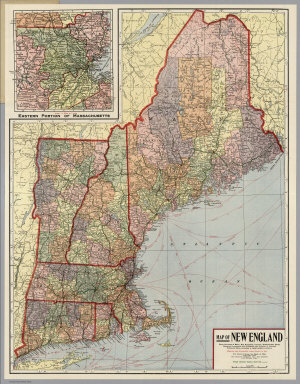
Kenyon Company
Full Title
Map of New England ... Copyright 1920 The Kenyon Company, Inc., Map Makers Des Moines, Iowa. Principal Automobile Highways Shown Thus ... (inset) Eastern Portion Of Massachusetts. (on verso) Index of New England States, With Official 1920 Census...
Publisher
The Kenyon Company, Inc.
Author
Brown, Harold Haven
Full Title
Picture map of Massachusetts. Designed and drawn by Harold Haven Brown. Published by R.R. Bowker Company, 62 West 45th St., New York, Copyright 1930. (insets) Boston during three centuries ; Battle of Bunker Hill ; Boston & country adjacent ; bunker Hill Monument.
Publisher
R.R. Bowker Company
Author
[Walker, G.H., Walker, O.W.]
Full Title
Index Map Massachusetts 1891.
Publisher
Geo.H. Walker & Co.
Author
[Walker, G.H., Walker, O.W.]
Full Title
Massachusetts. Atlas Plate No. 1.
Publisher
Geo.H. Walker & Co.
Author
[Walker, G.H., Walker, O.W.]
Full Title
Massachusetts. Atlas Plate No. 2.
Publisher
Geo.H. Walker & Co.
Author
[Walker, G.H., Walker, O.W.]
Full Title
Massachusetts. Atlas Plate No. 3.
Publisher
Geo.H. Walker & Co.
Author
[Walker, G.H., Walker, O.W.]
Full Title
Massachusetts. Atlas Plate No. 5.
Publisher
Geo.H. Walker & Co.
Author
[Walker, G.H., Walker, O.W.]
Full Title
Massachusetts. Atlas Plate No. 6.
Publisher
Geo.H. Walker & Co.
Author
[Walker, G.H., Walker, O.W.]
Full Title
Massachusetts. Atlas Plate No. 7.
Publisher
Geo.H. Walker & Co.
Author
[Walker, G.H., Walker, O.W.]
Full Title
Massachusetts. Atlas Plate No. 8.
Publisher
Geo.H. Walker & Co.
Author
[Walker, G.H., Walker, O.W.]
Full Title
Massachusetts. Atlas Plate No. 9.
Publisher
Geo.H. Walker & Co.
|