Who What Where WhenREMOVE |
Author
Bowen, Emanuel
Full Title
A new & accurate map of Mexico or New Spain together with California, New Mexico &c. Drawn from the best modern maps & charts & regulated by astronl. observns. By Eman: Bowen. (London: Printed for William Innys, Richard Ware, Aaron Ward, J. and P. Knapton, John Clarke, T. Longman and T. Shewell, Thomas Osborne, Henry Whitridge ... M.DCC.XLVII)
Publisher
William Innys [et al.]
Author
[Kartographia Winterthur, Conférence Suisse des Directeurs Cantonaux de l'instruction Publique]
Full Title
Etats - Unis et Mexique. Kartographia Winterthur S.A. Conference des Chefs des Depart. Cant. de l'Instruction Publique. Atlas Scolaire 2e. Edition. (with inset map) Le Suisse.
Publisher
Librairie Payot
Author
Wyld, James, 1812-1887
Full Title
(Covers to) Mexico The British Possessions In North America And The United States. London. Published By Jas. Wyld, Geographer To The Queen, Charing Cross East. 1846. James Wyld, Geographer to the Queen and to H.R.H. Prince Albert, Charing Cross, East, four doors from Trafalgar Square, London ... (inset) North America. (inset) Islands in the Pacific Ocean.
Publisher
James Wyld
Author
Wyld, James, 1812-1887
Full Title
(North Sheet) Mexico The British Possessions In North America And The United States. London. Published By Jas. Wyld, Geographer To The Queen, Charing Cross East. 1846. James Wyld, Geographer to the Queen and to H.R.H. Prince Albert, Charing Cross, East, four doors from Trafalgar Square, London ... (inset) North America. (inset) Islands in the Pacific Ocean.
Publisher
James Wyld
Author
Wyld, James, 1812-1887
Full Title
(South Sheet) Mexico The British Possessions In North America And The United States. London. Published By Jas. Wyld, Geographer To The Queen, Charing Cross East. 1846. James Wyld, Geographer to the Queen and to H.R.H. Prince Albert, Charing Cross, East, four doors from Trafalgar Square, London ... (inset) North America. (inset) Islands in the Pacific Ocean.
Publisher
James Wyld
Author
Wyld, James, 1812-1887
Full Title
(Composite to) Mexico The British Possessions In North America And The United States. London. Published By Jas. Wyld, Geographer To The Queen, Charing Cross East. 1846. James Wyld, Geographer to the Queen and to H.R.H. Prince Albert, Charing Cross, East, four doors from Trafalgar Square, London ... (inset) North America. (inset) Islands in the Pacific Ocean.
Publisher
James Wyld
Author
[Johnson, A.J., Johnson, D. Griffing]
Full Title
A New Map Of The Union, With The Adjacent Islands & Countries, From Authentic Sources. Published by D.G. & A.J. Johnson, Trinity Buildings, 111 Broadway, New-York. 1857 ... Entered ... 1856 by D.G. Johnson ... New York. (inset of northwest Missouri and adjacent parts of Kansas and Nebraska).
Publisher
D.G. & A.J. Johnson
Author
[Smith, J. Calvin, Smith, Robert P.]
Full Title
The New Naval And Military Map Of The United States. By J. Calvin Smith, Author Of Harper's Gazetteer, Colton's County Map Of The U.S. Travellers' Guide &c. 1862. J. Baker & Co. Publishers. J.M. Atwood, Map Engraver 517 Minor St. Philadelphia, Pa. Entered ... 1862 by Robert P. Smith ... Pennsylvania. (with 5 inset maps and 3 profiles).
Publisher
J. Baker
Author
Monk, Jacob
Full Title
Monk's Standard American Map Exhibiting the larger portion of North America; Embracing The United States And Territories, Mexico, And Central America, Including The West India Islands, The Canadas, New Brunswick And Nova Scotia. Compiled from recent Government surveys and other authentic sources. Baltimore. Drawn, Engraved & Printed by A. Hoen & Co. Second street. Published by Jacob Monk. 1859. (inset) New Map Of The World on Mercators Projection ...
Publisher
Jacob Monk
Author
[Gaston, Samuel N., Morse, Charles W.]
Full Title
A New Map Of Our Country Present And Prospective. Compiled from Government Surveys and other Reliable Sources. Published by J.G. Wells, New York. Mack R. Barnitz, Cincinnati, Ohio. 1859. Entered ... 1856 by Morse & Gaston ... New York. (inset) Map Of The World On Mercators Projection By Milo Doty. 1858.
Publisher
J.G. Wells
Author
[Cruchley, G., Laurie, Richard Holmes]
Full Title
Fredonia Or The United States of North America; Including Also Cabotia, Or The Canadian Provinces; The Western Territory California, Oregon and the Northern Part of the Mexican States. 1849.
Publisher
R. L. Laurie
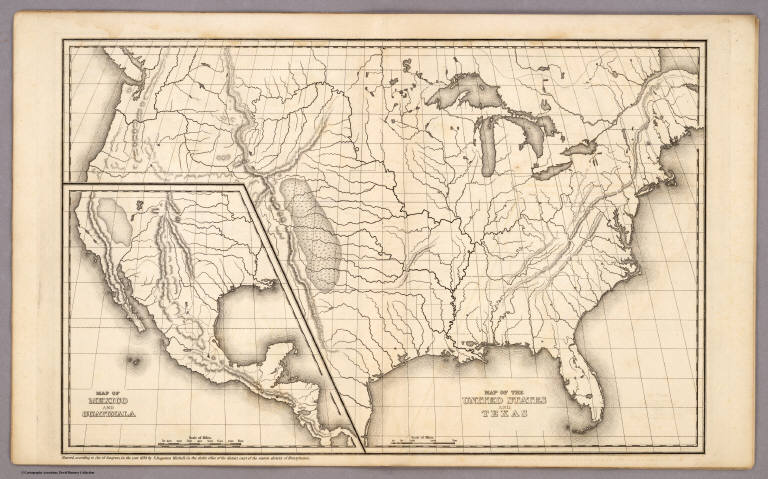
Author
Mitchell, Samuel Augustus
Full Title
Map of the United States and Texas Engraved to Illustrate Mitchell's School and Family Geography. No. 4. (with) Map of Mexico and Guatimala ... No. 5. Engraved by W. Williams. Entered ... 1839, by S. Augustus Mitchell ... Connecticut.
Publisher
Thomas, Cowperthwait & Co.
Author
Mitchell, Samuel Augustus
Full Title
Map of the United States and Texas. (with) Map of Mexico and Guatimala. Entered ... 1839, by S. Augustus Mitchell ... Pennsylvania.
Publisher
Thomas, Cowperthwait & Co.
Author
Andriveau-Goujon, E.
Full Title
(Covers to) Carte Generale Des Etats - Unis Et Du Mexique Comprenant L'Amerique Centrale Et Les Antilles. E. Andriveau-Goujon, Editeur. Paris, Rue Du Bac, 21. 1865 ... (with four inset maps).
Publisher
Andriveau-Goujon
Author
Andriveau-Goujon, E.
Full Title
Carte Generale Des Etats - Unis Et Du Mexique Comprenant L'Amerique Centrale Et Les Antilles. E. Andriveau-Goujon, Editeur. Paris, Rue Du Bac, 21. 1865 ... (with four inset maps).
Publisher
Andriveau-Goujon
Author
Atwood, J.M.
Full Title
(Covers to) Map Of The United States, Canada, Mexico, Central America, and the West India Islands With a Portion of Venezuela & New Granada; Showing the routes overland and by the Isthmus to California and Oregon, Also the new Boundaries of California, Utah, & New Mexico, Compiled from the latest Authorities. Engraved & Published By J.M. Atwood, No. 19 Beekman Street, New York. 1851. D. McLellan, Printr. Spruce St ... Entered ... 1851, by J.M. Atwood ... New York.
Publisher
J.M. Atwood
Author
Atwood, J.M.
Full Title
Map Of The United States, Canada, Mexico, Central America, and the West India Islands With a Portion of Venezuela & New Granada; Showing the routes overland and by the Isthmus to California and Oregon, Also the new Boundaries of California, Utah, & New Mexico, Compiled from the latest Authorities. Engraved & Published By J.M. Atwood, No. 19 Beekman Street, New York. 1851. D. McLellan, Printr. Spruce St ... Entered ... 1851, by J.M. Atwood ... New York.
Publisher
J.M. Atwood
Author
Bonne, Rigobert, 1727-1794
Full Title
Carte du Mexique ou de la Nlle. Espagne, contenant aussi le Nouveau Mexique, la Californie, avec une partie des pays adjacents. Projettee et assujettie au ciel. Par Mr. Bonne, Hydrog(raph)e du Roi. A Paris, Chez Lattre, rue St. Jaques (sic), a la Ville de Bordeaux. Avec priv. du Roi. 1771. Arrivet inv. & sculp.
Publisher
Lattre & Delalain
Author
Tanner, Henry S.
Full Title
A map of the United States, Mexico, Central America, California, Oregon, New Mexico, W. Indies &c. With the boundaries, of the several states, railroads, canals &c. by H.S. Tanner, No. 201 Broadway, New York. 1851.
Publisher
H.S. Tanner
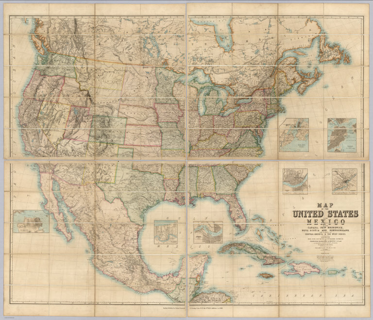
Author
[Johnston, Alexander Keith, 1804-1871, Rogers, Henry Darwin, Stanford, Edward]
Full Title
(Covers to) Map Of The United States And Mexico With Canada, New Brunswick, Nova Scotia and Newfoundland, And Parts Of Central America & The West Indies. Constructed From State Documents & Unpublished Materials By Professor H.D. Rogers of Boston U.S. and A. Keith Johnston, F.R.S.E Geographer to the Queen. London; Published by Edward Stanford, 6 Charing Cross, S.W. May 13th. 1861. Additions to 1869.
Publisher
Edward Stanford
Author
[Brue, Adrien Hubert, 1786-1832, Levasseur, E.]
Full Title
Carte Generale du Mexique, et de la partie Sud-Ouest Etats-Unis. Dresse par A. Brue, Geographe. Reoue par E. Levasseur, Membre de l'Institut, Institut Geographique de Paris. Ch. Delagrave. Editeur de la Societe de Geographie. 58 Rue des Ecoles. Carte de l'Amerique Centrale ou des Republicues de Guatemala, San Salvador, Honduras, Nicaragua, Costa Rica. Atlas Universel en 67 feuilles No. 61.
Publisher
Institut Geographique de Paris
Author
Smith, J. Calvin
Full Title
(United States, Mexico, Central America, Caribbean).
Publisher
Theodor Fischer
Author
[Colton, J. H., Johnson, A.J.]
Full Title
Johnson's New Illustrated & Embellished County Map Of The Republics Of North America With The Adjacent Islands & Countries, Compiled Drawn & Engraved From U. States Land & Coast Surveys, British Admiralty & other Reliable Sources. Under the Direction of A.J. Johnson. Published by J.H. Colton, 172, William Street, New York, Edition For Johnson & Browning. Richmond VA. 1860. Entered ... 1860 by J.H. Colton ... New York. Map Designed by A.J. Johnson. Engraved by D.G. Johnson, J.H. Goldthwait, W.S. Barnard, Wm. Wright, G. Rae Smith, F.H. King, James Duthie, J.L. White. (inset) Map Of The World on Mercator's Projection ...
Publisher
Johnson & Browning
Author
[Butterfield, Carlos, Johnson & Browning]
Full Title
United States and Mexican Mail Steamship Line, and Statistics of Mexico. By Carlos Butterfield, Washington. December, 1859. New York: J.A.H. Hasbrouck & Co., Printers ... 1860. (on verso) Entered ... 1859, by Carlos Butterfield ... New York. (With) Map of the United States and Mexico Published by Johnson & Browning under the direction of Col. Carlos Butterfield. December 1859.
Publisher
J.A.H. Hasbrouck & Co.
Author
[Butterfield, Carlos, Johnson & Browning]
Full Title
(Title page to) United States and Mexican Mail Steamship Line, and Statistics of Mexico. By Carlos Butterfield, Washington. December, 1859. New York: J.A.H. Hasbrouck & Co., Printers ... 1860. (on verso) Entered ... 1859, by Carlos Butterfield ... New York. (With) Map of the United States and Mexico Published by Johnson & Browning under the direction of Col. Carlos Butterfield. December 1859.
Publisher
J.A.H. Hasbrouck & Co.
Author
Mitchell, Samuel Augustus
Full Title
Mitchell's New National Map Exhibiting The United States With The North American British Provinces, Sandwich Islands, Mexico And Central America, Together with Cuba and other West India Islands. Philadelphia, Published By S. Augustus Mitchell. 1858. Engraved by W. Williams, Map Engraver Philadelphia. Constructed And Engraved By W. Williams, 33 South Fifth St. Philadelphia. Entered ... 1856 by S. Augustus Mitchell ... Pennsylvania. (inset) Map Of The World On The Mercator Projection ... (inset) Map Of The World On The Globular Projection ... (inset) Map Of The Sandwich Islands.
Publisher
S. Augustus Mitchell
Author
Rand McNally and Company
Full Title
(Text Page) Postal Information. Domestic Parcel Post. Alphabetical List of All Railroads.
Publisher
Rand McNally and Company
Author
Rand McNally and Company
Full Title
(Text Page) Alphabetical List of All Railroads.
Publisher
Rand McNally and Company
Author
Rand McNally and Company
Full Title
(Text Page) Alphabetical List of All Railroads.
Publisher
Rand McNally and Company
Author
Rand McNally and Company
Full Title
(Text Page) Alphabetical List of All Railroads.
Publisher
Rand McNally and Company
Author
Rand McNally and Company
Full Title
(Text Page) Alphabetical List of All Railroads. Railroads Grouped by Systems.
Publisher
Rand McNally and Company
Author
[Lubrecht, Charles, Rosa, R.]
Full Title
(Covers to) The American Continent. Topographical and railroad map of the United States, British Possessions, West Indies, Mexico and Central America. Compiled from the best authorities, by R. Rosa, late Col. 46th Regt. N.Y.S. Vol. Published by Ch. Lubrecht & Co., 12 Frankfort Street, New York. 1864. Agents For Great Britain: Bacon & Co., 48 Paternoster Row, London, England. For Germany, Switzerland And Italy: Fr. Volkmar, Leipsic. Lubrecht & Co., Stuttgart. Revised Edition. Entered ... 1864, by Ch. Lubrecht & Co. ... New York. (with) Central America.
Publisher
Charles Lubrecht & Co.
Author
[Lubrecht, Charles, Rosa, R.]
Full Title
The American Continent. Topographical and railroad map of the United States, British Possessions, West Indies, Mexico and Central America. Compiled from the best authorities, by R. Rosa, late Col. 46th Regt. N.Y.S. Vol. Published by Ch. Lubrecht & Co., 12 Frankfort Street, New York. 1864. Agents For Great Britain: Bacon & Co., 48 Paternoster Row, London, England. For Germany, Switzerland And Italy: Fr. Volkmar, Leipsic. Lubrecht & Co., Stuttgart. Revised Edition. Entered ... 1864, by Ch. Lubrecht & Co. ... New York. (with) Central America.
Publisher
Charles Lubrecht & Co.
Author
Johnston, Alexander Keith
Full Title
North America. By Keith Johnston, F.R.S.E. Keith Johnston's General Atlas. Engraved, Printed, and Published by W. & A.K. Johnston, Edinburgh & London.
Publisher
W.& A.K. Johnston
Author
Johnston, Alexander Keith
Full Title
North America. By Keith Johnston, F.R.S.E. Keith Johnston's General Atlas. Engraved, Printed, and Published by W. & A.K. Johnston, Edinburgh & London.
Publisher
W.& A.K. Johnston
Author
[Lowry, J.W., Sharpe, J.]
Full Title
Sharpe's Corresponding Maps. Central America. London - Published by Chapman and Hall, 186 Strand, 1848. Continental Series.
Publisher
Chapman & Hall
Author
[Black, Adam & Charles, Hall, Sidney, Hughes, William]
Full Title
Mexico, California & Texas. Edinburgh, Published by A. &. C. Black. Engraved by S. Hall, Bury Strt. Bloomsbry.
Publisher
Adam & Charles Black
Author
Johnston, W. & A.K.
Full Title
North America. Keith Johnston's General Atlas. Apr. 1912. Engraved, Printed, and Published by W. & A.K. Johnston, Limited, Edinburgh & London.
Publisher
W.& A.K. Johnston
Author
Monk, Jacob
Full Title
(Covers to) Monk's new map of Central America, Yucatan & Florida including Cuba, Jamaica and the Bahama Islands, exhibiting those portions of Alabama, Mississippi, Louisiana, Texas & Mexico bordering on the Gulf of Mexico. Compiled from the latest government maps and orther (sic) authentic sources. 1857. Baltimore, drawn, engraved and printed by A. Hoen & Co. and published by Jacob Monk. Entered ... 1856 by Jacob Monk ... Maryland. (with) Map of the World on Mercator's projection, exhibiting the continent of America in central position...
Publisher
Jacob Monk
Author
Monk, Jacob
Full Title
Monk's new map of Central America, Yucatan & Florida including Cuba, Jamaica and the Bahama Islands, exhibiting those portions of Alabama, Mississippi, Louisiana, Texas & Mexico bordering on the Gulf of Mexico. Compiled from the latest government maps and orther (sic) authentic sources. 1857. Baltimore, drawn, engraved and printed by A. Hoen & Co. and published by Jacob Monk. Entered ... 1856 by Jacob Monk ... Maryland. (with) Map of the World on Mercator's projection, exhibiting the continent of America in central position...
Publisher
Jacob Monk
Author
Carey, Mathew
Full Title
Missouri Territory formerly Louisiana. Bower, Sc.
Publisher
M. Carey and Son
Author
Vandermaelen, Philippe, 1795-1869
Full Title
(Composite of) Amer. Sep. no. 1 - 76. (Dresse par Ph. Vandermaelen, lithographie par H. Ode. Quatrieme partie. - Amer. sept. Bruxelles. 1827)
Publisher
Ph. Vandermaelen
Author
[Tardieu, P.F., Tardieu, P. (Pierre Antoine), 1784-1869]
Full Title
(Composite of) A Map of Louisiana and Mexico. Carte de la Louisiane et du Mexique, Dressee par P. Tardieu fils aine, Gravee par P.A.F. Tardieu pere. Paris 1820. A Paris, chez: P.A.F. Tardieu, Place de l'Estrapade No. 34. C. Piequet, Geographe Graveur, Quai Conti No. 17. J. Goujon, Marchand de Cartes Geographiques, Rue du Bac No. 6. New York. Anthy. Girard , Mercht. Agent for the Author. Ecrit par Richomme.
Publisher
J. (Jean) Goujon, 1793-1826
Author
[Tardieu, P.F., Tardieu, P. (Pierre Antoine), 1784-1869]
Full Title
A Map of Louisiana and Mexico (southern portion). Carte de la Louisiane et du Mexique, Dressee par P. Tardieu fils aine, Gravee par P.A.F. Tardieu pere. Paris 1820. A Paris, chez: P.A.F. Tardieu, Place de l'Estrapade No. 34. C. Piequet, Geographe Graveur, Quai Conti No. 17. J. Goujon, Marchand de Cartes Geographiques, Rue du Bac No. 6. New York. Anthy. Girard , Mercht. Agent for the Author. Ecrit par Richomme.
Publisher
J. (Jean) Goujon, 1793-1826
Author
Pinkerton, John, 1758-1826
Full Title
Spanish dominions in North America, northern part. Drawn under the direction of Mr. Pinkerton by L. Hebert. Neele sculpt. 352 Strand. London: published Novr. 1, 1811, by Cadell & Davies, Strand & Longman, Hurst, Rees, Orme, & Brown, Paternoster Row.
Publisher
[Cadell and Davies, Longman, Hurst, Rees, Orme, and Brown]
|