Who What Where WhenREMOVEWHATShow More |
Author
Colton, G.W. & C.B.
Full Title
Map Of The State Of North Carolina, With Portions Of Adjoining States. Published by G.W. & C.B. Colton & Co. 182 William Street, New York, 1886.
Publisher
G.W. & C.B. Colton
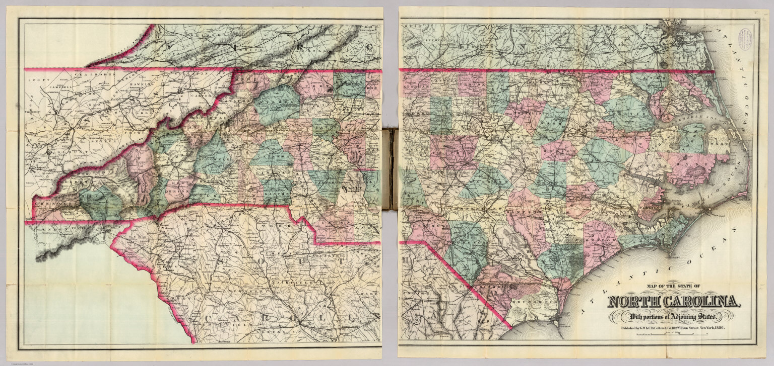
Author
Colton, G.W. & C.B.
Full Title
(Composite of) Map Of The State Of North Carolina, With Portions Of Adjoining States. Published by G.W. & C.B. Colton & Co. 182 William Street, New York, 1886.
Publisher
G.W. & C.B. Colton
Author
Mitchell, Samuel Augustus Jr.
Full Title
North and South Carolina. Entered ... 1874, by S. Augustus Mitchell ... Washington. (with inset maps) Plan of Charleston. Map of Charleston Harbor.
Publisher
S.A. Mitchell Jr.
Author
Johnson, A.J.
Full Title
Johnson's North And South Carolina By Johnson & Browning. No. 26-27.
Publisher
Johnson and Browning
Author
Mitchell, Samuel Augustus
Full Title
A New Map of Nth. (North) Carolina. (inset) Gold Region.
Publisher
Thomas, Cowperthwait & Co.
Author
Mitchell, Samuel Augustus
Full Title
A New Map of Nth. Carolina. With its Canals, Roads & Distances from place to place, along the Stage & Steam Boat Routes. Published by Charles Desilver, No. 251 Market Street Philadelphia. Entered ... 1856 by Charles Desilver ... Pennsylvania. (with three insets) The Newbern Region and the Gold Region. And Profile of the Dismal Swamp Canal.
Publisher
Charles DeSilver
Author
[Raynal, G.T., Bonne, R.]
Full Title
Carte de la partie sud des Etats Unis de l'Amerique septentrionale. Par M. Bonne, Ingenieur-Hydrographe de la Marine. (Grave par) Dien. (on upper margin) Liv. XVII, XVIII. : No. 48. (on lower margin) 49. (to accompany) Histoire Philosophique et Politique Des Establissements et Du Commerce Des Europeens Dans Les Deux Indes.
Publisher
Jean-Leonard Pellet
Author
National Map Company
Full Title
North Carolina. (Copyrighted by) National Map Company, Indianapolis. (Scale 1:2,200,000). South Carolina. (Copyrighted by) National Map Company, Indianapolis. (Scale 1:1,400,000), (to accompany) Official Paved Road and Commercial Survey of the United States.
Publisher
National Map Company
Author
Mitchell, Samuel Augustus Jr.
Full Title
North and South Carolina. (inset map) Plan of Charleston. 34. Map of Charleston Harbor. Entered ... 1867 by S. Augustus Mitchell, Jr. ... Pennsylvania.
Publisher
S.A. Mitchell Jr.
Author
United States. War Department
Full Title
Position of iron clads, January 15th, 1865. Engine "Hero" destroyed partially by rebels when avacuating (sic) Atlanta, Ga. (with) Rebel lines, Atlanta, Ga. looking across Augusta R.R. to the southward. (with) Rebel line on Augusta R.R. ... looking south. (with) Rebel lines on west side of Atlanta, Ga. looking southward. (with) Rebel lines, Atlanta, Ga. (with) U.S. Rolling Mill at Chattanooga, Tenn. (with) Ruins of rolling mill and cars destroyed by rebels on evacuation of Atlanta, Ga. (with) Round-house, Chattanooga R.R. at Atlanta, Ga. (with) Potter House, Atlanta, Ga. showing effects of bombardment. Julius Bien & Co., Lith., N.Y. (1891-1895)
Publisher
U.S. Government Printing Office
Author
[Confederate States of America. Army, Confederate States of America. Army. Corps of Engineers, Walker, William A.]
Full Title
Map of Charleston and its defenses, compiled from surveys of portions of St. Andrew's and Christ Ch. parishes by Lieut. John Johnson, C.S. Engrs ... Under the direction of Maj. Wm. H. Echols, C.S. Engr's Corps ... by Wm. A Walker, draughtsman ... Drawn by John R. Key ... Charleston, S.C., Nov. 28th 1863. (with) Map of New Berne, N.C. and defenses. Copied from Cleveland Rockwell's U.S. Coast Survey chart of New Berne and approaches, with additions under the direction of Lieut. Wm. R. King, U.S. Eng'rs. by Solon M. Allis, 27th Mass., July 1864. (with) Diagrams illustrating the 1st and 7th positions occupied by the 4th Division, 17th Army Corps, during the battle of Atlanta, Ga., July 22, 1864. Julius Bien & Co., Lith., N.Y. (1891-1895)
Publisher
U.S. Government Printing Office
Author
United States. War Department
Full Title
Section of map of parts of Brunswick and New Hanover counties showing the approaches to Wilmington, N.C. Department of Cape Fear, Maj. Gen. W.H.C. Whiting, commanding. Made under the direction of W.H. James, Ch. Eng'r. by B.L. Blackford ... Fort Caswell and adjoining works at western bar Cape Fear, N.C. Evacuated Jan. 16th 1865. Taken possession of ... Jan. 17th 1865. Line of rebel works, Smith's Island, N.C. Evacuated Jan. 16th 1865. Taken possession of ... Jan. 17th 1865. (both) North Atlantic Squadron, Read-Admiral D.D. Porter, commanding. Defenses of Augusta, Ga. From original in possession of Gen. Braxton Bragg, C.S. Army. (with) Fort Johnston, Smithville, N.C. ... (with) Augusta, Ga., 1864. (with) Plan of the fortifications at Columbus, Ga., 1864. (with) Map of the battle-field of Champion's Hill, Miss., May 16, 1863. Engineer's Office, Dept. of the Tenn., Capt. C.B. Comstock, Chief Engr. From surveys by F. Tunica ... and sketches by Brig. Gen. A.P. Hovey and Capt. A. Hickenlooper. Drawn by H.A. Ulffers ... Julius Bien & Co., Lith., N.Y. (1891-1895)
Publisher
U.S. Government Printing Office
Author
[Hoffman, Hoffmann, Ernest F., United States. War Department]
Full Title
Map illustrating the battle of Bentonville, N.C., fought March 19th 1865 between the United States forces commanded by Maj. Gen. H.W. Slocum and the rebel forces commanded by Gen. Jos. E. Johnston and the operations of March 20th and 21st under direction of Maj. Gen. W.T. Sherman ... Compiled under direction of O.M. Poe, Bvt. Col. U.S.A., by Major E.F. Hoffmann. (with) Map illustrating the battle of Averasborough, N.C. fought March 16th 1865 ... (with) Savannah, Ga., submitted with my report ... March 30th 1862. Q.A. Gillmore ... (with) Map of Bird's Point, Mo., from surveys in the summer of 1861. J.D. Webster, Mar. Actg. Engr. Julius Bien & Co., Lith., N.Y. (1891-1895)
Publisher
U.S. Government Printing Office
Author
[Twining, William J., United States. War Department]
Full Title
Map of Fort Anderson, N.C. Captured February 19th 1865 by the Army of the Ohio. Maj. Gen. J.M. Schofield, Comd'g. Official Wm. J. Twining, Capt. and Ch'f. Engr. (with) Map of Franklin, Tenn. Including field works and positions of troops 4th and 23rd Corps, during the engagement of November 30th 1864. Maj. Gen. Schofield, Comd'g. ... (with) Map of the battle-field of Droop Mountain drawn from a partial survey by Henry Topping. 6th Nov. 1863. (with) Battle-ground near White Sulphur Springs. August 26 and 27, 1863. Drawn by Lieut. J.R. Meigs, U.S. Engrs. (with Savannah and Wright rivers, S.C., Feb. 6, 1862). Accompanying report of Maj. O.T. Beard ... Julius Bien & Co., Lith., N.Y. (1891-1895)
Publisher
U.S. Government Printing Office
Author
[Julius Bien & Co., United States. War Department]
Full Title
General topographical map. Sheet III. Julius Bien & Co., Lith., N.Y. (1891-1895)
Publisher
U.S. Government Printing Office
Author
[Julius Bien & Co., United States. War Department]
Full Title
General topographical map. Sheet IV. (with) Entrance to Cape Fear River, North Carolina. Julius Bien & Co., Lith., N.Y. (1891-1895)
Publisher
U.S. Government Printing Office
Author
[Julius Bien & Co., United States. War Department]
Full Title
General topographical map. Sheet VII. Julius Bien & Co., Lith., N.Y. (1891-1895)
Publisher
U.S. Government Printing Office
Author
[Julius Bien & Co., United States. War Department]
Full Title
General topographical map. Sheet VIII. Julius Bien & Co., Lith., N.Y. (1891-1895)
Publisher
U.S. Government Printing Office
Author
[Bradford, Thomas G., Goodrich, S.G.]
Full Title
North Carolina. Engraved by G.W. Boynton. Entered ... 1838, by T.G. Bradford ... Massachusetts.
Publisher
C.D. Strong
Author
[Hinton, Isaac Taylor, 1799-1847, Simpkin & Marshall]
Full Title
Map of the states of North & South Carolina. (with) Plan of Charleston. London, published June 1 by I.T. Hinton & Simpkin & Marshall. Engraved & printed by Fenner Sears & Co. (1832)
Publisher
[Simpkin & Marshall, Thomas Wardle]
Full Title
N. & S. Carolina, Georgia & Florida. J.H. Young Sc. (Philadelphia: John Grigg, No. 9 North Fourth Street. 1830)
Publisher
John Grigg
Author
Letts, Son & Co.
Full Title
Eastern United States. No. 3. Letts's popular atlas. Letts, Son & Co. Limited, London. (1883)
Publisher
Letts, Son & Co.
Author
Lewis, Samuel
Full Title
North Carolina. Drawn by S. Lewis. Tanner sc. (Published by John Conrad & Co., Philadelphia. 1804)
Publisher
J. Conrad
Author
Lewis, Samuel
Full Title
North Carolina. Drawn by S. Lewis. Tanner sc. (Boston: Published by Thomas & Andrews. 1812)
Publisher
Thomas & Andrews
Full Title
(Map of North Carolina, South Carolina. Raleigh: Branson, Farrar & Co., Publishers. Biblical Recorder Print. 1863)
Publisher
Branson, Farrar & Co.
Full Title
North and South Carolina. (with) Plan of Charleston. (with) Map of Charleston Harbor. Copyright 1887 by Wm. M. Bradley & Bro. (1890)
Publisher
John Y. Huber & Co.
Full Title
North Carolina, South Carolina and Georgia. (with) Charleston and vicinity. N. & S.S. Jocelyn Sc. (New-Haven: N. & S.S. Jocelyn. 1823)
Publisher
N. & S.S. Jocelyn
Author
Mitchell, Samuel Augustus
Full Title
North and South Carolina. (with) Plan of Charleston. (with) Map of Charleston Harbor. Entered ... 1870 by S. Augustus Mitchell, Jr. ... Pennsylvania.
Publisher
[R.A. Campbell, S.A. Mitchell, Jr.]
Author
Mitchell, Samuel Augustus
Full Title
North and South Carolina. (with) Plan of Charleston. Entered ... 1879 by S. Augustus Mitchell ... Washington. (1880)
Publisher
S.A. Mitchell
Author
Greenleaf, Jeremiah
Full Title
North and South Carolina.
Publisher
G.R. French
Author
Carey, Mathew
Full Title
North Carolina. W. Barker sculp.
Publisher
Lang and Ustick
Author
Tanner, Henry S.
Full Title
Map of North & South Carolina. By H.S. Tanner. American Atlas.
Publisher
Henry Tanner
Author
Tanner, Henry S.
Full Title
Map of North & South Carolina. By H.S. Tanner. Published by H.S. Tanner, Philadelphia. Engraved by H.S. Tanner & Assistants. Entered ... 20th day of August 1823, by H.S. Tanner... Pennsylvania. American Atlas.
Publisher
Henry Tanner
Author
Tanner, Henry S.
Full Title
Map of North & South Carolina. By H.S. Tanner. Published by H.S. Tanner, Philadelphia. Engraved by H.S. Tanner & Assistants. Entered ... 20th day of August 1823, by H.S. Tanner... Pennsylvania. American Atlas.
Publisher
Henry Tanner
Author
Carey, Mathew
Full Title
The State of North Carolina from the best Authorities, &c. by Samuel Lewis. Engraved by Vallance.
Publisher
Mathew Carey
Author
[Bowen, Emanuel, Gibson, John]
Full Title
Carolina And Georgia. (to accompany) Atlas Minimus or a New Set of Pocket Maps of the Several Empires, Kingdoms and States of the Known World, with Historical Extracts relative to each. Drawn and Engraved by J. Gibson from the Best Authorities, Revis'd, Corrected and Improv'd by Eman: Bowen Geographer to His Majesty.
Publisher
J. Newberry
Author
Carey, Mathew
Full Title
The State of North Carolina from the best Authorities, &c. by Samuel Lewis. Engraved by Vallance.
Publisher
Mathew Carey
Author
Mitchell, Samuel Augustus
Full Title
A New Map of the State of North Carolina by J.L. Hazzard. Published By Charles Desilver, No. 714 Chesnut Street, Philadelphia. Entered according to Act of Congress in the year 1860 by Charles Desilver in the Clerk's office if the District Court of the Eastern District of Pennsylvania. 15.
Publisher
Charles Desilver.
Author
[Rand McNally and Company, State Farm Insurance Companies Travel Bureau]
Full Title
Rand McNally Road map, North Carolina, South Carolina. Copyright by Rand McNally & Company, Chicago, Ill. Lithographed in the U.S.A. (to accompany) State Farm Road Atlas: United States, Canada, Mexico,Central and South America. Copyright 1940 by Rand McNally & Company, Chicago, Ill.
Publisher
State Farm Insurance Companies Travel Bureau
Author
Carey, Mathew
Full Title
The State of North Carolina from the best Authorities, &c. by Samuel Lewis. Engraved by Vallance.
Publisher
M. Carey
Author
[Carey, Henry Charles, Lea, Isaac]
Full Title
N. & S.Carolina and Georgia. Young & Delleker, Sc. (to accompany) The Juvenile Atlas or a Series Of Maps, To Illustrate the Old and New Worlds ...1822.
Publisher
H.C. Carey & I. Lea
Author
Hillebrands, A.J.
Full Title
Atlas de Vereenigde Staten No. 6. North Carolina, South Carolina en Georgia.
Publisher
[J. Oomkens, J. Zoon]
Author
Bradstreet Company
Full Title
North Carolina. (to accompany) Bradstreet's Pocket Atlas Of The United States. Published Exclusively for Macullar, Parker & Company, Boston, Massachusetts ... New York: The Bradstreet Company, 1885. (on verso) Entered ... 1879, by The Bradstreet Company ... Washington.
Publisher
Bradstreet Co.
Author
Tanner, Henry S.
Full Title
North & South Carolina. (engraved by) J. Knight. Sc. (to accompany) A New Pocket Atlas of the United States With The Roads and Distances, Designed For the Use of Travelers. By H.S. Tanner. Philadelphia: Published by the Author. 1828. (on verso) ...on the seventeenth day of November ... 1828, Henry S. Tanner ... hath deposited ... a book ... Pennsylvania.
Publisher
H.S.Tanner
Author
[Taylor, Frank J., White, Ruth Taylor]
Full Title
North Carolina.
Publisher
Little, Brown, and Company
Author
Cram, George Franklin
Full Title
New Rail Road and Count Map of North Carolina.
Publisher
A.C. Shewey and Co.
Author
Tanner, Henry S.
Full Title
Map Of North & South Carolina By H.S. Tanner. Improved To 1825. American Atlas. Entered ... 20th day of August 1823, by H.S. Tanner ... Pennsylvania. Published by H.S. Tanner, Philadelphia. Engraved by H.S. Tanner & Assistants.
Publisher
Henry Tanner
Author
Bradford, Thomas G.
Full Title
North Carolina. (to accompany) A Comprehensive Atlas, Geographical, Historical & Commercial. By T.G. Bradford. William D. Ticknor, Boston. Wiley & Long, New-York. Entered ... 1835, by Thos. G. Bradford ... Massachusetts.
Publisher
[William D. Ticknor, Wiley & Long]
Author
Bradford, Thomas G.
Full Title
North Carolina, South Carolina and Georgia. (to accompany) A Comprehensive Atlas, Geographical, Historical & Commercial. By T.G. Bradford. William D. Ticknor, Boston. Wiley & Long, New-York. Entered ... 1835, by Thos. G. Bradford ... Massachusetts.
Publisher
[William D. Ticknor, Wiley & Long]
Author
[Morse, Sidney E., Breese, S.]
Full Title
North Carolina. (to accompany) Supplement To The New-York Observer. The Cerographic Atlas Of The United States. No.3. 1845. Entered ... 1843, by Sidney E. Morse and Samuel Breese ... New-York.
Publisher
Sidney E. Morse & Co.
|