Who What Where WhenREMOVEWHATShow MoreWHERE
|
Author
Faust, H.W.
Full Title
Faust's Map Of City And County Of San Francisco California. Published By H.W. Faust. Copyrighted 1894. Galloway Litho. Co. S.F. (inset) General View Of San Francisco Bay.
Publisher
H.W. Faust
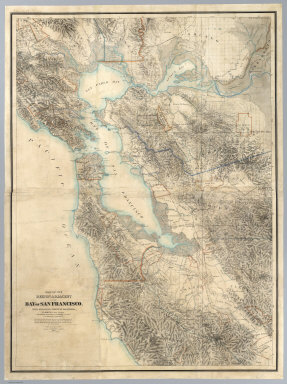
Author
[Hoffmann, Charles F., Whitney, J.D., Geological Survey of California]
Full Title
Map Of The Region Adjacent To The Bay Of San Francisco. State Geological Survey Of California, J.D. Whitney, State Geologist. W. H. Brewer, W. M. Gabb, and A. Rémond, Assistants. C.F. Hoffman, Topographer. The Coast, Rancho, Township and Section Lines from Materials furnished by the U.S. Coast Survey and the U.S. Surveyor General's Office, the Topography chiefly from Original Surveys by C.F. Hoffman ... 1867. Engraved by Julius Bien, N.Y.
Publisher
Julius Bien
Author
[Langley, Henry G., Wackenreuder, V.]
Full Title
City And County Of San Francisco. Compiled From Official Surveys And Sectionalized In Accordance With U.S. Surveys. Drawn By V. Wackenreuder, C.E. 1861. Published By Henry G. Langley For the San Francisco Directory. Entered ... 1861 By Henry G. Langley ... California. Britton & Co. Print. (with 3 inset maps of the Farrallon Islands).
Publisher
Henry Langley
Author
[Thomas Bros., Freese, Harry]
Full Title
Commercial and school map of California ; Compiled, published and copyrighted by Harry Freese ; published and for sale by Thomas Bros. (insets) San Francisco, Oakland and vicinity. Scale 1:335,000 ; Los Angeles and vicinity. Scale 1:335,000 ; Map showing township range survey system in California.
Publisher
Thomas Bros.
Author
Mitchell, Samuel Augustus Jr.
Full Title
County map of the state of California. Entered ... 1874, by S. Augustus Mitchell ... Washington. (insets) San Francisco, and San Francisco Bay and vicinity.
Publisher
S.A. Mitchell Jr.
Author
Mitchell, Samuel Augustus Jr.
Full Title
County map of California (inset maps) 52. Map of the Settlements in the Great Salt Lake Country. Utah. 53. San Francisco Bay and Vicinity. Entered ... 1867 by S. Augustus Mitchell, Jr. ... Pennsylvania.
Publisher
S.A. Mitchell Jr.
Author
Goddard, George H.
Full Title
City and County of San Francisco. Compiled from U.S. Land and Coast Surveys from the Official Surveys of the City, The Outside Lands. The Tide Land Commission and the Homestead Associations by George H. Goddard C.E. 1869. Lithographed & Published by Britton & Rey, Corr. Commercial & Leidesdorff Sts. S. Entered ... 1869.
Publisher
Britton & Rey
Author
[Johnston, Alexander Keith, 1804-1871, Rogers, Henry Darwin]
Full Title
New Orleans. San Francisco. London ... & according to an act of Congress ... 1857, by H.D. Rogers ... Massachusetts. London, John Murray, Albemarle Street, Edinburgh, W. & A.K. Johnston. Engraved by W. & A.K. Johnston, Edinburgh.
Publisher
Edward Stanford
Author
[Bennett, Edward H., Burnham, Daniel Hudson]
Full Title
(Covers to) Report on a plan for San Francisco by Daniel H. Burnham. Assisted by Edward H. Bennett. Presented to the Mayor and Board of Supervisors by the Association for the Improvement and Adornment of San Francisco. Edited by Edward F. O'Day. September, MCMV. Published by the City.
Publisher
City of San Francisco
Author
[Bennett, Edward H., Burnham, Daniel Hudson]
Full Title
(Title Page to) Report on a plan for San Francisco by Daniel H. Burnham. Assisted by Edward H. Bennett. Presented to the Mayor and Board of Supervisors by the Association for the Improvement and Adornment of San Francisco. Edited by Edward F. O'Day. September, MCMV. Published by the City. (verso: engraved and printed by Sunset Press, San Francisco)
Publisher
City of San Francisco
Author
[Bennett, Edward H., Burnham, Daniel Hudson]
Full Title
(Contents to) Report on a plan for San Francisco by Daniel H. Burnham. Assisted by Edward H. Bennett. Presented to the Mayor and Board of Supervisors by the Association for the Improvement and Adornment of San Francisco. Edited by Edward F. O'Day. September, MCMV. Published by the City.
Publisher
City of San Francisco
Author
[Bennett, Edward H., Burnham, Daniel Hudson, Meryon, Charles]
Full Title
(Preface to) Report on a plan for San Francisco by Daniel H. Burnham. Assisted by Edward H. Bennett. Presented to the Mayor and Board of Supervisors by the Association for the Improvement and Adornment of San Francisco. Edited by Edward F. O'Day. September, MCMV. Published by the City.
Publisher
City of San Francisco
Author
[Bennett, Edward H., Burnham, Daniel Hudson]
Full Title
(Preface to) Report on a plan for San Francisco by Daniel H. Burnham. Assisted by Edward H. Bennett. Presented to the Mayor and Board of Supervisors by the Association for the Improvement and Adornment of San Francisco. Edited by Edward F. O'Day. September, MCMV. Published by the City.
Publisher
City of San Francisco
Author
Goddard, George H. (George Henry), 1817-1906
Full Title
Bird's-eye view of the city of San Francisco and surrounding country. Drawing by George H. Goddard, 1868. (1905)
Publisher
City of San Francisco
Full Title
Panorama of the City from Twin Peaks. (By Daniel H. Burnham. Assisted by Edward H. Bennett. 1905)
Publisher
City of San Francisco
Full Title
View of the Golden Gate from the Bay, looking west. (By Daniel H. Burnham. Assisted by Edward H. Bennett. 1905)
Publisher
City of San Francisco
Full Title
View of water-front from Bay. (By Daniel H. Burnham. Assisted by Edward H. Bennett. 1905)
Publisher
City of San Francisco
Full Title
Bird's-eye perspective of the City from Twin Peaks, showing the proposed changes. (By Daniel H. Burnham. Assisted by Edward H. Bennett. 1905)
Publisher
City of San Francisco
Full Title
Bird's-eye perspective of the City from the east, showing the proposed changes. (By Daniel H. Burnham. Assisted by Edward H. Bennett. 1905)
Publisher
City of San Francisco
Full Title
Plan of San Francisco, showing system of circuit and radial arteries, and its communication with San Mateo County. (By Daniel H. Burnham. Assisted by Edward H. Bennett. 1905)
Publisher
City of San Francisco
Full Title
View of the natural yacht harbor, skirted by proposed boulevard, east of Fort Mason. (By Daniel H. Burnham. Assisted by Edward H. Bennett. 1905)
Publisher
City of San Francisco
Full Title
The Bay, looking north from proposed Outer Boulevard, near Fishermen's Wharf. (By Daniel H. Burnham. Assisted by Edward H. Bennett. 1905)
Publisher
City of San Francisco
Full Title
Panorama of the Bay from the Presidio, looking east. View of the Golden Gate from the proposed terrace in the Presidio. (By Daniel H. Burnham. Assisted by Edward H. Bennett. 1905)
Publisher
City of San Francisco
Full Title
View of the ocean and headlands, north, from the proposed terrace at Cliff House Rocks. (By Daniel H. Burnham. Assisted by Edward H. Bennett. 1905)
Publisher
City of San Francisco
Full Title
View of the ocean, south, from the proposed terrace at Cliff House Rocks. (By Daniel H. Burnham. Assisted by Edward H. Bennett. 1905)
Publisher
City of San Francisco
Full Title
View of Laguna de la Merced, looking west. (By Daniel H. Burnham. Assisted by Edward H. Bennett. 1905)
Publisher
City of San Francisco
Full Title
View of the City Hall, from Eighth Street. (By Daniel H. Burnham. Assisted by Edward H. Bennett. 1905)
Publisher
City of San Francisco
Full Title
View of the Golden Gate, from Ashbury and Seventeenth streets. (By Daniel H. Burnham. Assisted by Edward H. Bennett. 1905)
Publisher
City of San Francisco
Full Title
View of Twin Peaks, from the proposed square at Twenty-Third and Howard streets. (By Daniel H. Burnham. Assisted by Edward H. Bennett. 1905)
Publisher
City of San Francisco
Full Title
Glen Canyon, showing the Twin Peaks Group in the distance. (By Daniel H. Burnham. Assisted by Edward H. Bennett. 1905)
Publisher
City of San Francisco
Full Title
View of driveway through Glen Canyon. (By Daniel H. Burnham. Assisted by Edward H. Bennett. 1905)
Publisher
City of San Francisco
Full Title
Market Street termination and approach to Twin Peaks. (By Daniel H. Burnham. Assisted by Edward H. Bennett. 1905)
Publisher
City of San Francisco
Full Title
Panhandle, plan of proposed extension from Baker Street to the Civic Center. Panhandle, longitudinal section. (By Daniel H. Burnham. Assisted by Edward H. Bennett. 1905)
Publisher
City of San Francisco
Full Title
Section at Steiner Street, through A and B. Section at Fillmore Street, through C and D. (By Daniel H. Burnham. Assisted by Edward H. Bennett. 1905)
Publisher
City of San Francisco
Full Title
Plan of Civic Center. (By Daniel H. Burnham. Assisted by Edward H. Bennett. 1905)
Publisher
City of San Francisco
Full Title
View of Civic Center, looking from the south side of Market Street. (By Daniel H. Burnham. Assisted by Edward H. Bennett. 1905)
Publisher
City of San Francisco
Full Title
Typical plan of playground north of Washington Square. (By Daniel H. Burnham. Assisted by Edward H. Bennett. 1905)
Publisher
City of San Francisco
Full Title
View of the Twin Peaks Group, from Herman and Buchanan streets. (By Daniel H. Burnham. Assisted by Edward H. Bennett. 1905)
Publisher
City of San Francisco
Full Title
View of the Golden Gate from Twin Peaks. (By Daniel H. Burnham. Assisted by Edward H. Bennett. 1905)
Publisher
City of San Francisco
Full Title
Panorama: looking from Twin Peaks west to the sea. (By Daniel H. Burnham. Assisted by Edward H. Bennett. 1905)
Publisher
City of San Francisco
Full Title
View from Twin Peaks, showing South San Francisco. (By Daniel H. Burnham. Assisted by Edward H. Bennett. 1905)
Publisher
City of San Francisco
Full Title
View from Telegraph Hill, looking west. (By Daniel H. Burnham. Assisted by Edward H. Bennett. 1905)
Publisher
City of San Francisco
Full Title
View from Telegraph Hill, looking north. (By Daniel H. Burnham. Assisted by Edward H. Bennett. 1905)
Publisher
City of San Francisco
Full Title
View from Telegraph Hill, looking east. (By Daniel H. Burnham. Assisted by Edward H. Bennett. 1905)
Publisher
City of San Francisco
Full Title
View of Buena Vista Park and City, from Twin Peaks. (By Daniel H. Burnham. Assisted by Edward H. Bennett. 1905)
Publisher
City of San Francisco
Full Title
View of Twin Peaks, from Market Street, near Larkin Street. (By Daniel H. Burnham. Assisted by Edward H. Bennett. 1905)
Publisher
City of San Francisco
Full Title
View of Twin Peaks, from Market and Noe streets. (By Daniel H. Burnham. Assisted by Edward H. Bennett. 1905)
Publisher
City of San Francisco
Full Title
Twin Peaks, from Clarendon Heights, looking south. (By Daniel H. Burnham. Assisted by Edward H. Bennett. 1905)
Publisher
City of San Francisco
|