Who What Where WhenREMOVE |
Author
Cary, John, ca. 1754-1835
Full Title
A new map of Hindoostan, from the latest authorities, by John Cary, engraver, 1806. (with) Isle of Ceylon. London: Published by J. Cary, Engraver & Map-seller, No. 181, Strand, Decr. 1, 1806.
Publisher
John Cary
Author
Colton, G.W.
Full Title
Colton's Hindostan or British India. Published By G. W & C. B. Colton & Co., No. 182 William St. New York.
Publisher
G. W & C. B. Colton & Co.
Author
Colton, G.W.
Full Title
Colton's Hindostan or British India. Published By G. W & C. B. Colton & Co., No. 172 William St. New York.
Publisher
G. W & C. B. Colton & Co.
Author
Johnston, Alexander Keith, 1804-1871
Full Title
India, southern sheet, by Keith Johnston, F.R.S.E. (with) South-eastern provinces of India, Hindu-Chinese countries or Further India. Engraved & printed by W. & A.K. Johnston, Edinburgh. William Blackwood & Sons, Edinburgh & London, (1861)
Publisher
William Blackwood & Sons
Author
Johnston, Alexander Keith, 1804-1871
Full Title
(Composite of) India ... by Keith Johnston, F.R.S.E. (with) South-eastern provinces of India, Hindu-Chinese countries or Further India. Engraved & printed by W. & A.K. Johnston, Edinburgh. William Blackwood & Sons, Edinburgh & London, (1861)
Publisher
William Blackwood & Sons
Author
Garnier, F. A., 1803-1863
Full Title
Asie Meridionale, Inde Anglaise et Indo-Chine. Atlas spheroidal & universel de geographie dresse par F.A. Garnier, geographe. Paris, Ve. Jules Renouard, Editeur, r. de Tournon, no. 6. 1860. Imp. de Louis Antoine, Rue de Cluny, 1, Paris.
Publisher
Veuve Jules Renouard, Libraire
Author
Mitchell, Samuel Augustus
Full Title
Hindoostan. Entered ... 1850 by Thomas Cowperthwait & Co., ... Pennsylvania. (inset map) Delta of Ganges.
Publisher
Cowperthwait, Desilver & Butler
Author
Bartholomew, John
Full Title
(Index to) India South, India North-East. Conic Projection, Standard parallels 12 (degree) and 26 (degree) N. 1:4,000,000.
Publisher
[Houghton Mifflin Co., John Bartholomew & Son LTD.]
Author
Bartholomew, John
Full Title
India South, India North-East. 1:4,000,000. The Geographical Institute Edinburgh. Edited by John Bartholomew, M.C., LL.D. (Copyright), John Bartholomew & Son, LTD.
Publisher
[Houghton Mifflin Co., John Bartholomew & Son LTD.]
Author
Bartholomew, John
Full Title
(Index o) India North. Conic Projection, Standard parallels 12 (degree) and 26 (degree) N. 1:4,000,000.
Publisher
[Houghton Mifflin Co., John Bartholomew & Son LTD.]
Author
Bartholomew, John
Full Title
India North. 1:4,000,000. The Geographical Institute Edinburgh. Edited by John Bartholomew, M.C., LL.D. (Copyright), John Bartholomew & Son, LTD. (with three inset maps) Delhi, Calcutta, 1:200,000. Damodar Valley, 1:2,000,000.
Publisher
[Houghton Mifflin Co., John Bartholomew & Son LTD.]
Author
Bartholomew, John
Full Title
(Index to) India Plains, Mt. Everest. Lambert Conformal Conic Projection, Standard Parallels 6 (degree) and 30 (degree) N. 1:2,000,000.
Publisher
[Houghton Mifflin Co., John Bartholomew & Son LTD.]
Author
Bartholomew, John
Full Title
India Plains, Mt. Everest. 1:2,000,000. The Geographical Institute Edinburgh. Edited by John Bartholomew, M.C., LL.D. (Copyright), John Bartholomew & Son, LTD.
Publisher
[Houghton Mifflin Co., John Bartholomew & Son LTD.]
Author
[Thomson, John, Wyld, James, 1790-1836]
Full Title
Hindoostan. Drawn by J. Wyld. (engraved by) Hewitt Sc. ... Published by John Thomson & Co. Edinburgh. (to accompany) A General Atlas, Containing Maps illustrating some important periods in Ancient History; and distinct Maps of the several Empires, Kingdoms and States In The World, From Original Drawings according to the latest Treaties by J. Wyld and Engraved by N.R. Hewitt. Edinburgh, Printed for John Thomson & Co for Baldwin, Cradock & Joy, London & John Cumming, Dublin.
Publisher
John Thomson
Author
Hall, S. (Sidney)
Full Title
Hindoostan. By Sidney Hall. London, published by Longman, Rees, Orme, Brown & Green, Paternoster Row, Novr. 1st. 1827.
Publisher
Longman, Rees, Orme, Brown and Green
Author
Hall, S. (Sidney)
Full Title
Persia. By Sidney Hall. London, published by Longman, Rees, Orme, Brown & Green, Paternoster Row, August 1828.
Publisher
Longman, Rees, Orme, Brown and Green
Author
Radefeld, Carl Christian Franz, 1788-1874
Full Title
Neueste Karte von Vorder Indien oder Hindostan. Nach den bessten Quellen entworfen und gezeichnet von Hauptmann Radefeld. 1844. Verlag des Bibliograph. Instituts zu Hildburghsn., Amsterdam, Paris und Philadelphia, (1860)
Publisher
Bibliographischen Instituts
Author
Johnson, A.J.
Full Title
Johnson's Hindoostan and Farther India. Entered .... 1867.
Publisher
A.J. Johnson
Author
[Andriveau-Goujon, J., Marzolla, Benedetto]
Full Title
Turchia Asiatica, Arabia, Persia, Afghanistan, Herat, Belutchistan. La presente Carta e stata eseguita secondo quella, pubblicata in Parigi dal Sigr. S. Andriveau-Goujon ... Altante Geografico di B. Marzolla. Napoli, 1856.
Publisher
B. Marzolla
Author
Bartholomew, John
Full Title
(Composite of) Plates 28, 29, 30, 31, 32 India South, India North-East, India North, India Plains, Pakistan, Kashmir, Afghanistan, Iran. V. II
Publisher
[Houghton Mifflin Co., John Bartholomew & Son LTD.]
Author
Darton, William
Full Title
Hindoostan. London, Published April 3d 1812 by Wm. Darton Junr., No. 58 Holborn Hill.
Publisher
William Darton
Author
[Archibald Constable & Co., Edward Stanford Ltd., Stanford, Edward]
Full Title
Map of the North Western Frontier of India showing the Pamir Region and part of Afghanistan. Copyright Archd. Constable & Co. London: Stanford's Geographical Establishment. London : Edward Stanford, 26 & 27, Cockspur St., Charing Cross, S.W. (1901)
Publisher
Edward Stanford
Author
[Edward Stanford Ltd., Stanford, Edward]
Full Title
(India and the adjacent parts of Beluchistan, Afghanistan, Turkestan, the Chinese Empire, and Siam). India North. London atlas series. Stanford's Geogl. Estabt. London : Edward Stanford, 26 & 27, Cockspur St., Charing Cross, S.W. (1901)
Publisher
Edward Stanford
Author
[Edward Stanford Ltd., Stanford, Edward]
Full Title
India and the adjacent parts of Beluchistan, Afghanistan, Turkestan, the Chinese Empire, and Siam. India South. London atlas series. Stanford's Geogl. Estabt. London : Edward Stanford, 26 & 27, Cockspur St., Charing Cross, S.W. (1901)
Publisher
Edward Stanford
Author
[Edward Stanford Ltd., Stanford, Edward]
Full Title
(Composite of) India and the adjacent parts of Beluchistan, Afghanistan, Turkestan, the Chinese Empire, and Siam. London atlas series. Stanford's Geogl. Estabt. London : Edward Stanford, 26 & 27, Cockspur St., Charing Cross, S.W. (1901)
Publisher
Edward Stanford
Author
Flemming, Carl
Full Title
Vorderindien. Lithographie, Druck u. Verlag von C. Flemming in Glogau. (1855)
Publisher
C. Flemming
Full Title
Hindoostan. (Written and engraved by Jos. Perkins. 1845)
Publisher
Tanner's Geographical Establishment
Author
[Brue, Adrien Hubert, 1786-1832, Picquet, C.]
Full Title
Carte generale des Indes en-deca et au-dela du Gange par A.H. Brue, Geographe de S.A.R. Monsieur. Juin 1826. Augmentee et revue pour les limites en 1836. A Paris, Chez Chles. Picquet, Quai Conti No. 17, pres du Pont des Arts.
Publisher
C. Picquet
Author
Arrowsmith, John
Full Title
India, by J. Arrowsmith. London, pubd. 15 Feby. 1832 by J. Arrowsmith, 35 Essex Street, Strand.
Publisher
John Arrowsmith
Author
Brue, Adrien Hubert, 1786-1832
Full Title
Carte generale des Indes en-deca et au-dela du Gange, par A.H. Brue, Geographe de S.A.R. Monsieur. A Paris, Chez l'Auteur, rue des Macons-Sorbonne, no. 9, et chez les principaux marchands de geographie. Juin 1821.
Publisher
A. Brue
Author
Greenleaf, Jeremiah
Full Title
Hindostan.
Publisher
J. Greenleaf.
Author
[Menke, Th., Spruner von Merz, Karl]
Full Title
India. (with) India ad mentem Ptolemaei. (with) India sec. tabulam Peutingerianam. (with) India ad mentem Pomponii Melae. (with) India ap. Ammianum, Philostorgium, Stephanum Byz(antinum), etc. F.v. Stulpnagel del. Gothae: Justhus Perthes. Spruner-Menke atlas antiquus. (1865)
Publisher
Justus Perthes
Author
Ziegler, J. M.
Full Title
Ost Indien mit besonderer Berucksichtigung der englischen Besitzungen. Zum Atlas von J.M. Ziegler. Top. Anstalt v. J. Wurster u. Comp. Winterthur, Verlag von J. Wurster u. Comp. (1864)
Publisher
Joh. Wurster u. Comp.
Author
[Fremin, A.R., Monin, C.V., Montemont, A.]
Full Title
Asie Meridionale Comprenant L'Inde en Deca et au dela du Gange. Dressee par C.V. Monin. Armand Aubree, Editeur. Rue Taranne, 14. Grave sur Acier par L. Grenier, Rue des Noyers, No. 33, a Paris. Imprime par Mangeon. Ecrit par Benard, Rue St. Jacques, 51. (1837)
Publisher
Armand Aubree.
Author
Reichard, C. G.
Full Title
Ostindien von C.G. Reichard. Nurnberg, bei Fried. Campe. (1822)
Publisher
Friedrich Campe.
Author
Wyld, James, 1812-1887
Full Title
Map of India to Illustrate the Progress of the British Dominion from 1791 to 1857. J.W. del. London, James Wyld, Charing Cross East. (to accompany) An Atlas of the World, Comprehending Separate Maps of its various Countries, Constructed & drawn from the latest Astronomical & Geographical Observations. By James Wyld, Geographer to Her Majesty and H. Late R.H. Prince Albert. London. Published by James Wyld (Successor to Mr. Faden) Charing Cross East. 1864.
Publisher
James Wyld
Author
Cornell, S. S. (Sarah S.)
Full Title
Greece, Turkey in Asia and Persia. India. Entered ... 1856, by S.S. Cornell ... Southern District of New York. New York: D. Appleton & Co., 443 & 445 Broadway. (1864)
Publisher
Appleton & Co.
Author
Lattre, Jean
Full Title
Les Indes Orientales et leur archipel. A Paris, ches Lattre. Avec priv. (ca. 1800)
Publisher
C.F. Delamarche
Author
[J. & G. Menzies, Thomson, John]
Full Title
Hindoostan. (with) Isle of Ceylon. J. & G. Menzies sculpt., Edinr. (Drawn & engraved for Thomson's New general atlas, 1817)
Publisher
[Baldwin, Cradock, and Joy, John Cumming, John Thomson]
Author
Thomson, John
Full Title
Northern Hindostan. (with) Cabul. (with) Napaul. S.J. Neele sculp., 352 Strand. Drawn & engraved for Thomson's New general atlas, 1817.
Publisher
[Baldwin, Cradock, and Joy, John Cumming, John Thomson]
Author
[Lapie, Alexandre Emile, Lapie, M. (Pierre), 1779-1850]
Full Title
Carte de l'Inde en deca et au dela du Gange. Dressee par M. Lapie, 1er. Geographe du Roi et M. Lapie Fils, Geographe de S.A.R.M. le Dauphin. Paris, 1829. Chez Eymery Fruger et Cie., Rue Mazarine No. 30. La gravure dirigee et executee par Lallemand.
Publisher
Eymery Fruger et Cie
Author
Lizars, Daniel
Full Title
Hindostan. (with) Isle of Ceylon. Published by D. Lizars, Edinburgh. (1831?)
Publisher
[John Hamilton, W. Curry, Jun. & Co., Whittaker, Treacher & Co.]
Author
[Bartholomew, J. G. (John George), 1860-1920, John Bartholomew and Son]
Full Title
South-western Asia. The Edinburgh Geographical Institute, John Bartholomew & Son, Ltd. "The Times" atlas. (London: The Times, 1922)
Publisher
The Times
Author
Letts, Son & Co.
Full Title
General map of India. Letts's popular atlas. Letts, Son & Co. Limited, London. (1883)
Publisher
Letts, Son & Co.
Author
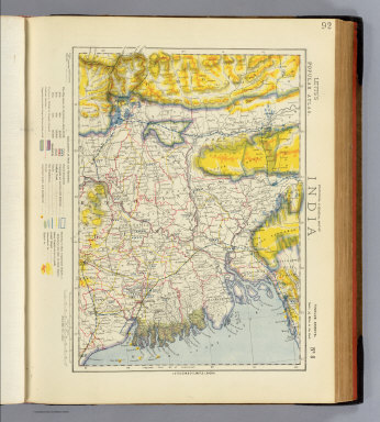
Letts, Son & Co.
Full Title
Statistical & general map of India. No. 8. Letts's popular atlas. Letts, Son & Co. Limited, London. (1883)
Publisher
Letts, Son & Co.
Author
[Bartholomew, J. G. (John George), 1860-1920, John Bartholomew & Co.]
Full Title
Persia. The Edinburgh Geographical Institute, John Bartholomew & Co. "The Times" atlas. (London: The Times, 1922)
Publisher
The Times
Author
[Bartholomew, J. G. (John George), 1860-1920, John Bartholomew and Son]
Full Title
(Composite of) Section maps of the Near East. The Edinburgh Geographical Institute, John Bartholomew & Son, Ltd. "The Times" atlas. (London: The Times, 1922)
Publisher
The Times
Author
Robert Laurie & James Whittle
Full Title
(A new map of Hindoostan from the latest authorities. North half. Chiefly from the actual surveys made by major James Rennell, Surveyor to the Hble. East India Company, of the Bengal Provinces, and of the countries lying between them and Delhy; the whole exhibiting all the military roads and passes, as well as the most accurate division of the British possessions in the East Indies. London, Published by Laurie & Whittle, 53, Fleet Street, 12th May, 1794. 2nd editn. corrected 1804)
Publisher
Laurie & Whittle
Author
[Rennell, James, 1742-1830, Robert Laurie & James Whittle]
Full Title
A new map of Hindoostan from the latest authorities. (South half). Chiefly from the actual surveys made by major James Rennell, Surveyor to the Hble. East India Company, of the Bengal Provinces, and of the countries lying between them and Delhy; the whole exhibiting all the military roads and passes, as well as the most accurate division of the British possessions in the East Indies. London, Published by Laurie & Whittle, 53, Fleet Street, 12th May, 1794. 2nd editn. corrected 1804.
Publisher
Laurie & Whittle
Author
[Rennell, James, 1742-1830, Robert Laurie & James Whittle]
Full Title
(Composite of) A new map of Hindoostan from the latest authorities. Chiefly from the actual surveys made by major James Rennell, Surveyor to the Hble. East India Company, of the Bengal Provinces, and of the countries lying between them and Delhy; the whole exhibiting all the military roads and passes, as well as the most accurate division of the British possessions in the East Indies. London, Published by Laurie & Whittle, 53, Fleet Street, 12th May, 1794. 2nd editn. corrected 1804.
Publisher
Laurie & Whittle
|