Who What Where WhenREMOVEWHERE
|
Full Title
Township 16 South, Range 22 East, Tulare Co., California. (with) Map of Mt. Whitney Colony ... (with) Map of Level Orchard Land Colony ... (with) Map of Mack's Addition to Orosi Colony ... (Compiled, drawn and published by Thos. H. Thompson, Tulare, Cal., 1892)
Publisher
T.H. Thompson
Full Title
Township 16 South, Range 23 East, Tulare Co., California. (Compiled, drawn and published by Thos. H. Thompson, Tulare, Cal., 1892)
Publisher
T.H. Thompson
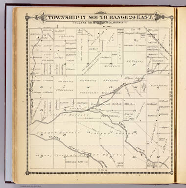
Full Title
Township 16 South, Range 24 East, Tulare Co., California. (Compiled, drawn and published by Thos. H. Thompson, Tulare, Cal., 1892)
Publisher
T.H. Thompson
Full Title
Map of the town of Monson, Tulare County. (with) Map of Lindsay, Tulare County. (with) Map of Zumwalt's subdivision ... (with) Map of Galicia Vineyard ... (Compiled, drawn and published by Thos. H. Thompson, Tulare, Cal., 1892)
Publisher
T.H. Thompson
Full Title
Township 16 South, Range 25 East, Tulare Co., California. (Compiled, drawn and published by Thos. H. Thompson, Tulare, Cal., 1892)
Publisher
T.H. Thompson
Full Title
Township 16 South, Range 26 East, Tulare Co., California. (Compiled, drawn and published by Thos. H. Thompson, Tulare, Cal., 1892)
Publisher
T.H. Thompson
Full Title
Ranch of B.B. Smith, Bellville, Tulare Co., Cal. Ranch of Charles Oettle, Woodville, Tulare Co., Cal. E.D. Castle, proprietor (Castle Stable) , Tulare, Cal. Livery stable and residence of R. Scally, Lemoore, Tulare Co., Cal. (1892)
Publisher
T.H. Thompson
Full Title
Township 16 South, Range 27 East, Tulare Co., California. (Compiled, drawn and published by Thos. H. Thompson, Tulare, Cal., 1892)
Publisher
T.H. Thompson
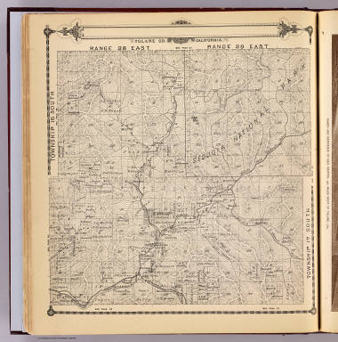
Full Title
Township 16 South, Township 17 South, Range 28 East, Range 29 East, Tulare Co., California. (Compiled, drawn and published by Thos. H. Thompson, Tulare, Cal., 1892)
Publisher
T.H. Thompson
Full Title
Ranch and residence of Geo. Bertch, 9 1/2 miles west of Tulare, Cal. (1892)
Publisher
T.H. Thompson
Full Title
Township 16 South, Township 17 South, Range 30 East, Range 31 East, Tulare Co., California. (Compiled, drawn and published by Thos. H. Thompson, Tulare, Cal., 1892)
Publisher
T.H. Thompson
Full Title
Cosmopolitan Hotel, Tulare City, Cal. I.H. Ham, proprietor. Oakland Co-operative Fruit and Raisin Growing Co., 3 miles S.W. of Tulare, Cal. Amos Roberts, manager. (1892)
Publisher
T.H. Thompson
Full Title
Township 17 South, Range 23 East, Tulare Co., California. (Compiled, drawn and published by Thos. H. Thompson, Tulare, Cal. 1892)
Publisher
T.H. Thompson
Full Title
Vineyard of E. Barris, Traver, Tulare Co., Cal. Burris Point fruit ranch, apiary and residence of F.M. Hart, near Traver, Tulare Co., Cal. Ranch and residence of C.J. Hobler, breeder of French and Spanish Merino rams, 6 miles N.E. of Hanford, Tulare Co., Cal. (1892)
Publisher
T.H. Thompson
Full Title
Map of Traver, Tulare County. (with) Map of Coe Colony, Tulare Co. (with) Map of Kitchener Colony, Tulare County. (with) Map of Traver Colony, Tulare County. (1892)
Publisher
T.H. Thompson
Full Title
Township 17 South, Range 24 East, Tulare Co., California. (Compiled, drawn and published by Thos. H. Thompson, Tulare, Cal. 1892)
Publisher
T.H. Thompson
Full Title
Scene on J(asper) Harrell's 6000 acre ranch, seven miles north of Visalia, Tulare Co., Cal. (with) Residence of A.J. Harrell, 80 acres, near Visalia, Cal. (with) Bank building of J. Harrell, Visalia, Cal. (1892)
Publisher
T.H. Thompson
Full Title
Township 17 South, Range 25 East, Tulare Co., California. (Compiled, drawn and published by Thos. H. Thompson, Tulare, Cal. 1892)
Publisher
T.H. Thompson
Full Title
Township 17 South, Range 26 East, Tulare Co., California. (Compiled, drawn and published by Thos. H. Thompson, Tulare, Cal. 1892)
Publisher
T.H. Thompson
Full Title
Township 17 South, Range 27 East, Tulare Co., California. (Compiled, drawn and published by Thos. H. Thompson, Tulare, Cal. 1892)
Publisher
T.H. Thompson
Author
[U.S. Geological Survey, Alpha, Tau Rho]
Full Title
Mount Whitney and Vicinity, Tulare and Inyo Counties, California.
Publisher
U.S. Geological Survey
Author
Baker, P.Y.
Full Title
Map Of Tulare County California Compiled from actual Surveys by P.Y. Baker C.E. 1876. G.W. Terry, Map Colorer & Mounter, Rice's Building, 79 Dearborn St., Chicago, Ill. Approved and declared to be the Official Map of Tulare County by resolution of the Board of Supervisors, August, 1876. W.C. Owen, E.H. Baker, James Barton, Board of Supervisors. (with 4 inset maps).
Publisher
No Publisher
Author
[Hall, Wm. Ham. (William Hammond), California Department of Engineering]
Full Title
California State Engineering Department. Detail Irrigation Map. Centerville and Kingsburgh Sheet. Wm. Ham. Hall, State Engineer. Irrigation Data 1885.
Publisher
California Department of Engineering
Author
[Hall, Wm. Ham. (William Hammond), California Department of Engineering]
Full Title
California State Engineering Department. Detail Irrigation Map. Lemoore and Hanford Sheet. Wm. Ham. Hall, State Engineer. Irrigation Data 1885.
Publisher
California Department of Engineering
Author
[Hall, Wm. Ham. (William Hammond), California Department of Engineering]
Full Title
California State Engineering Department. Detail Irrigation Map. Traver and Tulare Sheet. Wm. Ham. Hall, State Engineer. Irrigation Data 1885.
Publisher
California Department of Engineering
Author
[Hall, Wm. Ham. (William Hammond), California Department of Engineering]
Full Title
California State Engineering Department. Detail Irrigation Map. Visalia Sheet. Wm. Ham. Hall, State Engineer. Irrigation Data 1885.
Publisher
California Department of Engineering
Author
[Hall, Wm. Ham. (William Hammond), California Department of Engineering]
Full Title
California State Engineering Department. Detail Irrigation Map. Porterville Sheet. Tipton Sheet. Wm. Ham. Hall, State Engineer. Irrigation Data 1885.
Publisher
California Department of Engineering
Author
[Hall, Wm. Ham. (William Hammond), California Department of Engineering]
Full Title
(Composite of) California State Engineering Department. Detail Irrigation Map(s) consisting of the following sheets: Fresno, Centerville and Kingsburgh, Lemoore and Hanford, Traver and Tulare, Visalia, Tipton, and Porterville. Wm. Ham. Hall, State Engineer. Irrigation Data 1885.
Publisher
California Department of Engineering
Author
[Hall, Wm. Ham. (William Hammond), California State Engineering Department]
Full Title
California State Engineering Department. Topographical And Irrigation Map Of The San Joaquin Valley. Sheet No. 3. Wm. Ham. Hall, State Engineer, 1886. Note. This Topographical and Irrigation Map of San Joaquin Valley is published in four sheets, as follows: Sheet No. 1, from Tp. 4 N. to 1st Standard South. Sheet No. 2, from 1st to 3d Standard South. Sheet No. 3, from 3d to 5th Standard South. Sheet No. 4, from 5th to 8th Standard South. It is intended as a general illustration of the present extent of irrigation, and a means of studying its future possible development ...
Publisher
California State Engineering Department
Author
[Hall, Wm. Ham. (William Hammond), California State Engineering Department]
Full Title
California State Engineering Department. Topographical And Irrigation Map Of The San Joaquin Valley. Sheet No. 4. Wm. Ham. Hall, State Engineer, 1886. Note. This Topographical and Irrigation Map of San Joaquin Valley is published in four sheets, as follows: Sheet No. 1, from Tp. 4 N. to 1st Standard South. Sheet No. 2, from 1st to 3d Standard South. Sheet No. 3, from 3d to 5th Standard South. Sheet No. 4, from 5th to 8th Standard South. It is intended as a general illustration of the present extent of irrigation, and a means of studying its future possible development ...
Publisher
California State Engineering Department
|