Who What Where WhenREMOVE |
Author
Burr, David H., 1803-1875
Full Title
Map of Maine, New Hampshire, Vermont, Massachusetts, Rhode Island, and Connecticut. Exhibiting the Post Offices, Post Roads, Canals, Rail Roads, &c. By David H. Burr. (Late Topographer to the Post Office.) Geographer to the House of Representatives of the U.S. John Arrowsmith. Entered ... July 10th, 1839, by David H. Burr ... District of Columbia.
Publisher
John Arrowsmith
Author
Jefferys, Thomas
Full Title
(Composite of) A Map of the most Inhabited part of New England, containing the Provinces of Massachusetts Bay and New Hampshire, with the Colonies of Conecticut And Rhode Island, Divided into Counties and Townships: The Whole composed from Actual Surveys and its Situation adjusted by Astronomical Observations. (with) A Plan of the Town of Boston. November 29th 1774. Published according to Act by Thos. Jefferys Geographer to His Royal highness the Prince of Wales near Charing Cross.
Publisher
Sayer and Bennett
Author
Jefferys, Thomas
Full Title
The Provinces of New York, and New Jersey; with part of Pensilvania, and the Province of Quebec. Drawn by Major Holland, Engraved by Thomas Jefferys, Geographer to His Majesty. Corrected and Improved, from the Original Materials, By Governr. Pownall, Member of Parliament 1776. (with) three inset maps: A Chart Of The Mouth Of Hudson's River, from Sandy Hook to New York; A Plan Of The City Of New York; and Plan Of Amboy, With its Environs, from an Actual Survey. London. Printed for Robt Sayer & John Bennett ... 17 Augt. 1776.
Publisher
Sayer and Bennett
Author
Morse, Jedidiah
Full Title
A Map of the Northern and Middle States; Comprehending the Western Territory and the British Dominions in North America. from the best Authorities. Engraved by G. Allen, Sadlers Wells Row, Islington. Engraved for Morse's Geography, Published by J. Stockdale Jany. 25, 1792.
Publisher
John Stockdale
Author
Cary, John, ca. 1754-1835
Full Title
A new map of part of the United States of North America, containing those of New York, Vermont, New Hampshire, Massachusets (sic), Connecticut, Rhode Island, Pennsylvania, New Jersey, Delaware, Maryland and Virginia. From the latest authorities. By John Cary, engraver. 1806. London: Published by J. Cary, Engraver & Map-seller, No. 181, Strand, Sept. 1, 1806.
Publisher
John Cary
Author
Vandermaelen, Philippe, 1795-1869
Full Title
(Composite of) Amer. Sep. no. 34, 35, 36, 41, 42, 43, 44, 49, 50, 51, 56, 57, 57bis, 61, 62. (Dresse par Ph. Vandermaelen, lithographie par H. Ode. Quatrieme partie. - Amer. sept. Bruxelles. 1827)
Publisher
Ph. Vandermaelen
Author
[Fisher, Richard Swainson, Dinsmore & Co.]
Full Title
(Covers to) Dinsmore's Complete Map Of The Railroads & Canals In The United States & Canada Carefully Compiled from Authentic Sources by Richard S. Fisher, Editor Of The American Rail Road & Steam Navigator Guide. New-York. Published By Dinsmore & Company, No. 9 Spruce St. Engraved In Relief For Power Press Printing by Schonberg & Co. Acrographers, 75 Nassau Street New York 1856. Entered ... 1856 by Dinsmore & Co. ... New York.
Publisher
Dinsmore & Company
Author
[Fisher, Richard Swainson, Dinsmore & Co.]
Full Title
Dinsmore's Complete Map Of The Railroads & Canals In The United States & Canada Carefully Compiled from Authentic Sources by Richard S. Fisher, Editor Of The American Rail Road & Steam Navigator Guide. New-York. Published By Dinsmore & Company, No. 9 Spruce St. Engraved In Relief For Power Press Printing by Schonberg & Co. Acrographers, 75 Nassau Street New York 1856. Entered ... 1856 by Dinsmore & Co. ... New York.
Publisher
Dinsmore & Company
Author
Colton, G.W. & C.B.
Full Title
(Covers to) Map showing the Line of The New Haven, Middletown And Boston Railroad and its connections. Published by G.W. And C.B. Colton, & Co. 172 William St. New York. 1867. Entered ... 1867 by G.W. & C.B. Colton & Co ... New York.
Publisher
G.W. & C.B. Colton.
Author
Colton, G.W. & C.B.
Full Title
Map showing the Line of The New Haven, Middletown And Boston Railroad and its connections. Published by G.W. And C.B. Colton, & Co. 172 William St. New York. 1867. Entered ... 1867 by G.W. & C.B. Colton & Co ... New York.
Publisher
G.W. & C.B. Colton.
Author
Vandermaelen, Philippe, 1795-1869
Full Title
Partie des Etats-Unis. Amer. Sep. no. 43. Dressee et dessinee par Ph. Vandermaelen. Desee. sur pierre et Lith. par H. Ode et Ph. Lippens, mars 1825. (Quatrieme partie. - Amer. sept. Bruxelles. 1827)
Publisher
Ph. Vandermaelen
Author
Vandermaelen, Philippe, 1795-1869
Full Title
Partie des Etats-Unis. Amer. Sep. no. 51. Dressee et dessinee par Ph. Vandermaelen. La lettre par Ph. Lippens. Desinee sur pierre et Lithoge. par H. Ode, Mai 1825. (Quatrieme partie. - Amer. sept. Bruxelles. 1827)
Publisher
Ph. Vandermaelen
Author
Society for the Diffusion of Useful Knowledge (Great Britain)
Full Title
North America sheet VI. New-York, Vermont, Maine, New-Hampshire, Massachusetts, Connecticut, Rhode-Island, and New-Jersey. J. & C. Walker sculpt. Published by the Society for the Diffusion of Useful Knowledge. Published Sept. 1st. 1832 by Baldwin & Cradock, 47 Paternoster Row, London. (London: Chapman & Hall, 1844)
Publisher
Chapman and Hall
Author
Society for the Diffusion of Useful Knowledge (Great Britain)
Full Title
North America sheet VII. Pennsylvania, New Jersey, Maryland, Delaware, Columbia and part of Virginia. Published under the superintendence of the Society for the Diffusion of Useful Knowledge. J. & C. Walker sculpt. Published July 15th. 1833 by Baldwin & Cradock, 47 Paternoster Row, London. Printed by J. & C. Walker. (London: Chapman & Hall, 1844)
Publisher
Chapman and Hall
Author
Asher & Adams
Full Title
Asher & Adams' New Hampshire, Vermont, Massachusetts, Rhode Island and Connecticut. Entered according to Act of Congress in the year 1874 by Asher & Adams ... at Washington. (New York, 1874)
Publisher
Asher and Adams
Author
Rand McNally and Company
Full Title
(Covers to) Rand McNally Junior Road Map New England. Copyright By Rand McNally & Co. Chicago Ill. Made In U.S.A. ...
Publisher
Rand McNally & Co.
Author
Rand McNally and Company
Full Title
Rand McNally Junior Road Map New England. Copyright By Rand McNally & Co. Chicago Ill. Made In U.S.A. ...
Publisher
Rand McNally & Co.
Author
Williams, Alexander
Full Title
(Covers to) Telegraph and Rail Road Map of the New England States, by Alex. Williams. 1855. Redding & Co. Publishers, 8 State Street, Boston. Entered ... 1854 by Alexander Williams ... Massachusetts. (with inset map) Map of Boston Showing the entrance of the Rail Roads, by Alexr. Williams. Boynton Sc.
Publisher
Redding & Co.
Author
Williams, Alexander
Full Title
Telegraph and Rail Road Map of the New England States, by Alex. Williams. 1855. Redding & Co. Publishers, 8 State Street, Boston. Entered ... 1854 by Alexander Williams ... Massachusetts. (with inset map) Map of Boston Showing the entrance of the Rail Roads, by Alexr. Williams. Boynton Sc.
Publisher
Redding & Co.
Author
Johnston, Alexander Keith, 1804-1871
Full Title
United States of North America, eastern states, by Keith Johnston, F.R.S.E. Engraved & printed by W. & A.K. Johnston, Edinburgh. William Blackwood & Sons, Edinburgh & London, (1861)
Publisher
William Blackwood & Sons
Author
Tanner, Henry S.
Full Title
(Covers to) Map Of The States Of Maine, New Hampshire, Vermont, Massachusetts, Connecticut & Rhode Island. By H.S. Tanner 1847. Engraved & Published by H.S. Tanner, Philadelphia.
Publisher
H.S. Tanner
Author
Tanner, Henry S.
Full Title
Map Of The States Of Maine, New Hampshire, Vermont, Massachusetts, Connecticut & Rhode Island. By H.S. Tanner 1847. Engraved & Published by H.S. Tanner, Philadelphia.
Publisher
H.S. Tanner
Author
Finley, Anthony
Full Title
(Covers to) (Pocket Atlas Of The New England States And New York). (with 7 maps) Connecticut. New York. Maine. New Hampshire. Vermont. Massachusetts. Rhode Island. Published by A. Finley Philada. Young & Delleker Sc.
Publisher
Anthony Finley
Author
Finley, Anthony
Full Title
Connecticut. (Pocket Atlas Of The New England States And New York). (with 7 maps) Connecticut, New York. Maine. New Hampshire. Vermont. Massachusetts. Rhode Island. Published by A. Finley Philada. Young & Delleker Sc.
Publisher
Anthony Finley
Author
Finley, Anthony
Full Title
New York. (Pocket Atlas Of The New England States And New York). (with 7 maps) Connecticut, New York. Maine. New Hampshire. Vermont. Massachusetts. Rhode Island. Published by A. Finley Philada. Young & Delleker Sc.
Publisher
Anthony Finley
Author
Finley, Anthony
Full Title
Maine. (Pocket Atlas Of The New England States And New York). (with 7 maps) Connecticut, New York. Maine. New Hampshire. Vermont. Massachusetts. Rhode Island. Published by A. Finley Philada. Young & Delleker Sc.
Publisher
Anthony Finley
Author
Finley, Anthony
Full Title
New Hampshire. (Pocket Atlas Of The New England States And New York). (with 7 maps) Connecticut, New York. Maine. New Hampshire. Vermont. Massachusetts. Rhode Island. Published by A. Finley Philada. Young & Delleker Sc.
Publisher
Anthony Finley
Author
Finley, Anthony
Full Title
Vermont. (Pocket Atlas Of The New England States And New York). (with 7 maps) Connecticut, New York. Maine. New Hampshire. Vermont. Massachusetts. Rhode Island. Published by A. Finley Philada. Young & Delleker Sc.
Publisher
Anthony Finley
Author
Finley, Anthony
Full Title
Massachusetts. (Pocket Atlas Of The New England States And New York). (with 7 maps) Connecticut, New York. Maine. New Hampshire. Vermont. Massachusetts. Rhode Island. Published by A. Finley Philada. Young & Delleker Sc.
Publisher
Anthony Finley
Author
Finley, Anthony
Full Title
Rhode Island. (Pocket Atlas Of The New England States And New York). (with 7 maps) Connecticut, New York. Maine. New Hampshire. Vermont. Massachusetts. Rhode Island. Published by A. Finley Philada. Young & Delleker Sc.
Publisher
Anthony Finley
Author
New York Herald
Full Title
Map Of The Seat Of War In Virginia. Positions of the Rebel Forces, Batteries, Intrenchments and Encampments in Virginia. The Fortifications for the Protection of Richmond.
Publisher
New York Herald
Author
[Sauthier, Claude Joseph, Faden, William]
Full Title
A Map of the Province of New - York, Reduced from the large Drawing of that Province, Compiled from Actual Surveys by Orders of His Excellency William Tryon Esqr. Captain General & Governor of the fame, By Claude Joseph Sauthier; to which is added New - Jersey from the Topographical Observations of C.J. Sauthier & B. Ratzer. Engraved by William Faden, (Successor to the late Mr. Thos Jefferys) 1776.
Publisher
No publisher
Author
Mitchell, Samuel Augustus
Full Title
Canada West. Formerly Upper Canada. Published by Thomas, Cowperthwait & Co. No. 253 Market Street. Philadelphia. Entered ... 1850 by Thomas, Cowperthwait & Co. ... Pennsylvania. (inset map) Vicinity of the Falls of Niagara, and the City of Toranto and its Environs.
Publisher
Cowperthwait, Desilver & Butler
Author
Ensign & Thayer
Full Title
Map Of New England. Published By Ensign & Thayer, 50 Ann Street, New York, and 12 Exchange St., Buffalo. Entered ... 1847, by Ensigns & Thayer ... New York. Jos. Ward, 52 Cornhill, Boston.
Publisher
Ensign & Thayer
Author
Traubel, M.H.
Full Title
Map Illustrating The Position Of Duluth In The United States. M.H. Traubel's Lithographic Establishment 409 Chestnut St. Phila.
Publisher
M.H. Traubel
Author
Bartholomew, John
Full Title
(Index to) U.S.A. North-East. Lambert Conformal Conic Projection, Standard Parallels 33 (degrees) and 45 (degrees) N. 1:2,500,000.
Publisher
[Houghton Mifflin Co., John Bartholomew & Son LTD.]
Author
Bartholomew, John
Full Title
U.S.A. North-East. The Geographical Institute Edinburgh. Edited by John Bartholomew, M.C. LL. D. Copyright - John Bartholomew & Son, LTD.
Publisher
[Houghton Mifflin Co., John Bartholomew & Son LTD.]
Author
[Heermans, Anna A., Cogswell, Charlotte B.]
Full Title
(Covers to) A Hieroglyphic Geography Of The United States. Part 1 Containing The States Of Maine, New Hampshire, Vermont, Massachusetts, Rhode Island, Connecticut And New York. Designed And Drawn By Anna A. Heermans. Engraved By Charlotte B. Cogswell, Cooper Union Engraving School, New York. New York, E.P. Dutton And Company, 713 Broadway, 1875. (on verso) Entered ... 1874, by Charlotte B. Cogswell ... Washington. Riverside, Cambridge: Electrotyped And Printed By H.O. Houghton And Company.
Publisher
E.P. Dutton & Co.
Author
[Heermans, Anna A., Cogswell, Charlotte B.]
Full Title
(Title Page to) A Hieroglyphic Geography Of The United States. Part 1 Containing The States Of Maine, New Hampshire, Vermont, Massachusetts, Rhode Island, Connecticut And New York. Designed And Drawn By Anna A. Heermans. Engraved By Charlotte B. Cogswell, Cooper Union Engraving School, New York. New York, E.P. Dutton And Company, 713 Broadway, 1875. (on verso) Entered ... 1874, by Charlotte B. Cogswell ... Washington. Riverside, Cambridge: Electrotyped And Printed By H.O. Houghton And Company.
Publisher
E.P. Dutton & Co.
Author
[Heermans, Anna A., Cogswell, Charlotte B.]
Full Title
(Text Page to) A Hieroglyphic Geography Of The United States. Part 1 Containing The States Of Maine, New Hampshire, Vermont, Massachusetts, Rhode Island, Connecticut And New York. Designed And Drawn By Anna A. Heermans. Engraved By Charlotte B. Cogswell, Cooper Union Engraving School, New York. New York, E.P. Dutton And Company, 713 Broadway, 1875. (on verso) Entered ... 1874, by Charlotte B. Cogswell ... Washington. Riverside, Cambridge: Electrotyped And Printed By H.O. Houghton And Company.
Publisher
E.P. Dutton & Co.
Author
[Heermans, Anna A., Cogswell, Charlotte B.]
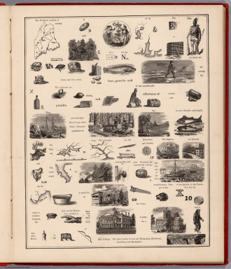
Full Title
(Text Page to) Maine. (to accompany) A Hieroglyphic Geography Of The United States. Part 1 Containing The States Of Maine, New Hampshire, Vermont, Massachusetts, Rhode Island, Connecticut And New York. Designed And Drawn By Anna A. Heermans. Engraved By Charlotte B. Cogswell, Cooper Union Engraving School, New York. New York, E.P. Dutton And Company, 713 Broadway, 1875. (on verso) Entered ... 1874, by Charlotte B. Cogswell ... Washington. Riverside, Cambridge: Electrotyped And Printed By H.O. Houghton And Company.
Publisher
E.P. Dutton & Co.
Author
[Heermans, Anna A., Cogswell, Charlotte B.]
Full Title
(View to) Maine. (to accompany) A Hieroglyphic Geography Of The United States. Part 1 Containing The States Of Maine, New Hampshire, Vermont, Massachusetts, Rhode Island, Connecticut And New York. Designed And Drawn By Anna A. Heermans. Engraved By Charlotte B. Cogswell, Cooper Union Engraving School, New York. New York, E.P. Dutton And Company, 713 Broadway, 1875. (on verso) Entered ... 1874, by Charlotte B. Cogswell ... Washington. Riverside, Cambridge: Electrotyped And Printed By H.O. Houghton And Company.
Publisher
E.P. Dutton & Co.
Author
[Heermans, Anna A., Cogswell, Charlotte B.]
Full Title
(Text Page to) Maine. (to accompany) A Hieroglyphic Geography Of The United States. Part 1 Containing The States Of Maine, New Hampshire, Vermont, Massachusetts, Rhode Island, Connecticut And New York. Designed And Drawn By Anna A. Heermans. Engraved By Charlotte B. Cogswell, Cooper Union Engraving School, New York. New York, E.P. Dutton And Company, 713 Broadway, 1875. (on verso) Entered ... 1874, by Charlotte B. Cogswell ... Washington. Riverside, Cambridge: Electrotyped And Printed By H.O. Houghton And Company.
Publisher
E.P. Dutton & Co.
Author
[Heermans, Anna A., Cogswell, Charlotte B.]
Full Title
(Text Page to) New Hampshire. (to accompany) A Hieroglyphic Geography Of The United States. Part 1 Containing The States Of Maine, New Hampshire, Vermont, Massachusetts, Rhode Island, Connecticut And New York. Designed And Drawn By Anna A. Heermans. Engraved By Charlotte B. Cogswell, Cooper Union Engraving School, New York. New York, E.P. Dutton And Company, 713 Broadway, 1875. (on verso) Entered ... 1874, by Charlotte B. Cogswell ... Washington. Riverside, Cambridge: Electrotyped And Printed By H.O. Houghton And Company.
Publisher
E.P. Dutton & Co.
Author
[Heermans, Anna A., Cogswell, Charlotte B.]
Full Title
(View to) New Hampshire. (to accompany) A Hieroglyphic Geography Of The United States. Part 1 Containing The States Of Maine, New Hampshire, Vermont, Massachusetts, Rhode Island, Connecticut And New York. Designed And Drawn By Anna A. Heermans. Engraved By Charlotte B. Cogswell, Cooper Union Engraving School, New York. New York, E.P. Dutton And Company, 713 Broadway, 1875. (on verso) Entered ... 1874, by Charlotte B. Cogswell ... Washington. Riverside, Cambridge: Electrotyped And Printed By H.O. Houghton And Company.
Publisher
E.P. Dutton & Co.
Author
[Heermans, Anna A., Cogswell, Charlotte B.]
Full Title
(Text Page to) New Hampshire. (to accompany) A Hieroglyphic Geography Of The United States. Part 1 Containing The States Of Maine, New Hampshire, Vermont, Massachusetts, Rhode Island, Connecticut And New York. Designed And Drawn By Anna A. Heermans. Engraved By Charlotte B. Cogswell, Cooper Union Engraving School, New York. New York, E.P. Dutton And Company, 713 Broadway, 1875. (on verso) Entered ... 1874, by Charlotte B. Cogswell ... Washington. Riverside, Cambridge: Electrotyped And Printed By H.O. Houghton And Company.
Publisher
E.P. Dutton & Co.
Author
[Heermans, Anna A., Cogswell, Charlotte B.]
Full Title
(Text Page to) Vermont. (to accompany) A Hieroglyphic Geography Of The United States. Part 1 Containing The States Of Maine, New Hampshire, Vermont, Massachusetts, Rhode Island, Connecticut And New York. Designed And Drawn By Anna A. Heermans. Engraved By Charlotte B. Cogswell, Cooper Union Engraving School, New York. New York, E.P. Dutton And Company, 713 Broadway, 1875. (on verso) Entered ... 1874, by Charlotte B. Cogswell ... Washington. Riverside, Cambridge: Electrotyped And Printed By H.O. Houghton And Company.
Publisher
E.P. Dutton & Co.
Author
[Heermans, Anna A., Cogswell, Charlotte B.]
Full Title
(View to) Vermont. (to accompany) A Hieroglyphic Geography Of The United States. Part 1 Containing The States Of Maine, New Hampshire, Vermont, Massachusetts, Rhode Island, Connecticut And New York. Designed And Drawn By Anna A. Heermans. Engraved By Charlotte B. Cogswell, Cooper Union Engraving School, New York. New York, E.P. Dutton And Company, 713 Broadway, 1875. (on verso) Entered ... 1874, by Charlotte B. Cogswell ... Washington. Riverside, Cambridge: Electrotyped And Printed By H.O. Houghton And Company.
Publisher
E.P. Dutton & Co.
Author
[Heermans, Anna A., Cogswell, Charlotte B.]
Full Title
(Text Page to) Vermont. (to accompany) A Hieroglyphic Geography Of The United States. Part 1 Containing The States Of Maine, New Hampshire, Vermont, Massachusetts, Rhode Island, Connecticut And New York. Designed And Drawn By Anna A. Heermans. Engraved By Charlotte B. Cogswell, Cooper Union Engraving School, New York. New York, E.P. Dutton And Company, 713 Broadway, 1875. (on verso) Entered ... 1874, by Charlotte B. Cogswell ... Washington. Riverside, Cambridge: Electrotyped And Printed By H.O. Houghton And Company.
Publisher
E.P. Dutton & Co.
Author
[Heermans, Anna A., Cogswell, Charlotte B.]
Full Title
(Text Page to) Massachusetts. (to accompany) A Hieroglyphic Geography Of The United States. Part 1 Containing The States Of Maine, New Hampshire, Vermont, Massachusetts, Rhode Island, Connecticut And New York. Designed And Drawn By Anna A. Heermans. Engraved By Charlotte B. Cogswell, Cooper Union Engraving School, New York. New York, E.P. Dutton And Company, 713 Broadway, 1875. (on verso) Entered ... 1874, by Charlotte B. Cogswell ... Washington. Riverside, Cambridge: Electrotyped And Printed By H.O. Houghton And Company.
Publisher
E.P. Dutton & Co.
|