Who What Where WhenREMOVE |
Author
[Allen, Paul, Biddle, Nicholas, Clark, William, Lewis, Meriwether]
Full Title
Lower Falls of the Columbia.
Publisher
Longman, Hurst, Rees etc.
Author
[Allen, Paul, Biddle, Nicholas, Clark, William, Lewis, Meriwether]
Full Title
Mouth of Columbia River. Neele sc. Strand. Published April 28th, 1814 by Longman & Co. Paternoster Row.
Publisher
Longman, Hurst, Rees etc.
Author
Pike, Zebulon Montgomery
Full Title
(Title Page to) An Account of Expeditions to the Sources of the Mississippi, and Through the Western Parts of Louisiana, to the Sources of the Arkansaw, Kans, La Platte, and Pierre Jaun, Rivers; ... During the Years 1805, 1806, and 1807. And a Tour Through the Interior Parts of New Spain, When Conducted Through These Provinces, by order of The Captain-General, in the year 1807. By Major Z.M. Pike. Illustrated by Maps and Charts. Philadelphia: Published by C. & A. Conrad & Co. No. 30, Chesnut Street. Somervell & Conrad, Petersburgh. Bonsal, Conrad, & Co. Norfolk, and Fielding Lucas, Jr. Baltimore. John Binns, Printer....1810.
Publisher
C. & A. Conrad
Author
Pike, Zebulon Montgomery
Full Title
Falls of St. Anthony.
Publisher
C. & A. Conrad
Author
Sage, Rufus B.
Full Title
(Title Page to) Scenes in the Rocky Mountains, and in Oregon, California, New Mexico, Texas, and the Grand Prairies; or Notes by the Way, During An Excursion Of Three Years, with a Description of the Countries Passed Through, including their Geography, Geology, Resources, Present Condition, and The Different Nations Inhabiting Them. By A New Englander. Philadelphia: Published By Carey & Hart. 1846. (on verso) Entered ... 1846, by Rufus B. Sage ... New-York.
Publisher
Carey & Hart
Author
Sage, Rufus B.
Full Title
Map of Oregon, California, New Mexico, N.W. Texas & the proposed Territory of Ne-Bras-Ka. By Rufus B. Sage. 1846. F. Michelin's Lith. 111 Nassau St. N.Y.
Publisher
Carey & Hart
Author
Gregg, Josiah, 1806-1850
Full Title
(Title Page to) Commerce of the Prairies: Or the Journal of a Santa Fe Trader, During Eight Expeditions Across The Great Western Prairies, and a residence of nearly nine years in Northern Mexico. Illustrated with Maps and Engravings. By Josiah Gregg. In two volumes. New York: Henry G. Langley, 8 Astor House. London: Wiley and Putnam, 6 Waterloo Place. M DCCC XLIV. (on verso) Entered ... 1844, by Henry G. Langley ... New-York.
Publisher
[Henry G. Langley, Wiley and Putnam.]
Author
Gregg, Josiah, 1806-1850
Full Title
A Map of the Indian Territory Northern Texas and New Mexico Showing the Great Western Prairies by Josiah Gregg. Entered ... 1844 by Sidney E. Morse and Samuel Breese ... New York.
Publisher
[Henry G. Langley, Wiley and Putnam.]
Author
[Allen, Paul, Biddle, Nicholas, Clark, William, Lewis, Meriwether]
Full Title
(Title Page to) History Of The Expedition Under The Command Of Captains Lewis And Clark, To The Sources Of The Missouri, Thence Across The Rocky Mountains And Down The River Columbia To The Pacific Ocean. Performed During The Years 1804-5-6. By order of the Government Of The United States. Prepared For The Press By Paul Allen, Esquire. In Two Volumes. Vol. I. Philadelphia: Published By Bradford And Inskeep, New York. J. Maxwell, Printer. 1814 ... Vol. II.
Publisher
Bradford and Inskeep
Author
[Allen, Paul, Biddle, Nicholas, Clark, William, Lewis, Meriwether]
Full Title
A Map of Lewis and Clark's Track, Across the Western Portion of North America From the Mississippi to the Pacific Ocean; By Order of the Executive of the United States, in 1804, 5 & 6. Copied by Samuel Lewis from the Original Drawing of Wm. Clark. Smal. Harrison fct.
Publisher
Bradford and Inskeep
Author
[Allen, Paul, Biddle, Nicholas, Clark, William, Lewis, Meriwether]
Full Title
The Falls and Portage.
Publisher
Bradford and Inskeep
Author
[Allen, Paul, Biddle, Nicholas, Clark, William, Lewis, Meriwether]
Full Title
Great Falls of Columbia River.
Publisher
Bradford and Inskeep
Author
[Allen, Paul, Biddle, Nicholas, Clark, William, Lewis, Meriwether]
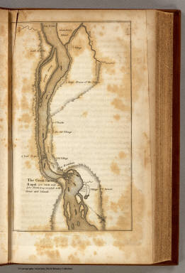
Full Title
The Great Shoot or Rapid.
Publisher
Bradford and Inskeep
Author
[Allen, Paul, Biddle, Nicholas, Clark, William, Lewis, Meriwether]
Full Title
Mouth of Columbia River.
Publisher
Bradford and Inskeep
Author
Pinkerton, John, 1758-1826
Full Title
Spanish dominions in North America, northern part. Drawn under the direction of Mr. Pinkerton by L. Hebert. Neele sculpt. 352 Strand. London: published Novr. 1, 1811, by Cadell & Davies, Strand & Longman, Hurst, Rees, Orme, & Brown, Paternoster Row.
Publisher
[Cadell and Davies, Longman, Hurst, Rees, Orme, and Brown]
Author
[United States Exploring Expedition (1838-1842), Wilkes, Charles, 1798-1877, Wyld, James, 1812-1887]
Full Title
(Covers to) Map of the Oregon Territory by the U. S. Ex. Ex. Charles Wilkes, Esqr. Commander, 1841. Re - Published by James Wyld Charing Cross East London. [1844] (with inset:) Columbia River Reduced from a Survey made by the U. S. Ex. Ex 1841.
Publisher
James Wyld
Author
[United States Exploring Expedition (1838-1842), Wilkes, Charles, 1798-1877, Wyld, James, 1812-1887]
Full Title
Map of the Oregon Territory by the U. S. Ex. Ex. Charles Wilkes, Esqr. Commander, 1841. Re - Published by James Wyld Charing Cross East London. [1844] (with inset:) Columbia River Reduced from a Survey made by the U. S. Ex. Ex 1841.
Publisher
James Wyld
|