Who What Where WhenREMOVEWHATShow More |
Author
Lloyd, J.T.
Full Title
Lloyd's New Map of the United States, The Canadas And New Brunswick ... 1864 ... Entered ... 1863, by J.T Lloyd ... New York. (untitled inset map of Southern Florida). (on verso) Lloyd's Map of the Lower Mississippi River From St. Louis To The Gulf Of Mexico. Compiled From Government Surveys In The Topographical Bureau, Washington, D.C. Revised and corrected to the present time by Captains Bart and William Bowen ... Price, in sheets, Colored, 50 Cents per copy. Pocket Edition, $1.00. Mounted Edition on Rollers and Varnished, $1.00 ... J.T. Lloyd, Publisher. 164 Broadway, New York 1863. Entered ... 1862, by J.T. Lloyd ... New York.
Publisher
J.T. Lloyd
Author
The Geological Society of America
Full Title
Pleistocene Eolian Deposits of the United States, Alaska and parts of Canada.
Publisher
The Geological Society of America
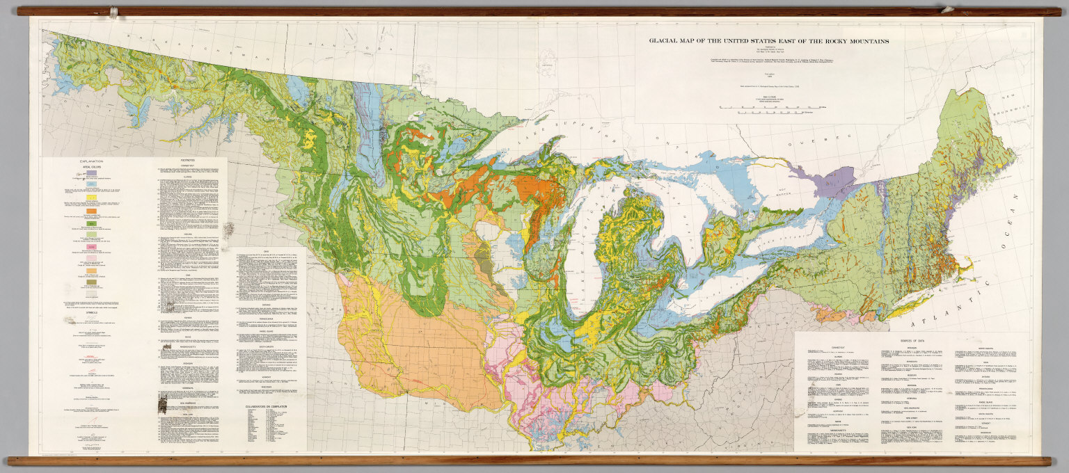
Author
[The Geological Society of America, Flint, Richard F.]
Full Title
Glacial Map of the United States East of the Rocky Mountains.
Publisher
The Geological Society of America
Author
[National Geographic Society, Garver Jr., John B., Garrett, Wilbur E.]
Full Title
The United States.
Publisher
National Geographic Society
Author
Bradford, Thomas G.
Full Title
(Covers to) An Illustrated Atlas, Geographical, Statistical, And Historical, Of The United States And The Adjacent Countries. By T.G. Bradford. Boston: Weeks, Jordan, And Company. New York: Wiley And Putnam. (on verso) Entered ... 1838, by Thomas G. Bradford ... Massachusetts. Cambridge: Stereotyped And Printed By Folsom, Wells, And Thurston, Printers To The University.
Publisher
[Weeks, Jordan & Co., Wiley and Putnam.]
Author
Bradford, Thomas G.
Full Title
(Title Page One to) An Illustrated Atlas, Geographical, Statistical, And Historical, Of The United States And The Adjacent Countries. By T.G. Bradford. Boston: Weeks, Jordan, And Company. New York: Wiley And Putnam. (on verso) Entered ... 1838, by Thomas G. Bradford ... Massachusetts. Cambridge: Stereotyped And Printed By Folsom, Wells, And Thurston, Printers To The University.
Publisher
[Weeks, Jordan & Co., Wiley and Putnam.]
Author
[U.S. Northern Boundary Commission, Campbell, Archibald, Twining, W.J.]
Full Title
(Covers to) Reports upon the Survey of the Boundary Between the Territory of the United States and the Possessions of Great Britain from the Lake of the Woods to the Summit of the Rocky Mountains, authorized by an Act of Congress Approved March 19, 1872. Archibald Campbell, Esq., (and) Captain W.J. Twining ... Published in accordance with an Act of Congress Approved March 3, 1877. Washington: Government Printing Office. 1878.
Publisher
Government Printing Office
Author
[U.S. Northern Boundary Commission, Campbell, Archibald, Twining, W.J.]
Full Title
(View) Chief Mountain (Looking West)
Publisher
Government Printing Office
Author
[U.S. Northern Boundary Commission, Campbell, Archibald, Twining, W.J.]
Full Title
(Title Page) Reports upon the Survey of the Boundary Between the Territory of the United States and the Possessions of Great Britain from the Lake of the Woods to the Summit of the Rocky Mountains, authorized by an Act of Congress Approved March 19, 1872. Archibald Campbell, Esq., (and) Captain W.J. Twining ... Published in accordance with an Act of Congress Approved March 3, 1877. Washington: Government Printing Office. 1878.
Publisher
Government Printing Office
Author
[U.S. Northern Boundary Commission, Campbell, Archibald, Twining, W.J.]
Full Title
(Section Title Page) Message from the President of the United States.
Publisher
Government Printing Office
Author
[U.S. Northern Boundary Commission, Campbell, Archibald, Twining, W.J.]
Full Title
(Text Page) (Message from the President of the United States.)
Publisher
Government Printing Office
Author
[U.S. Northern Boundary Commission, Campbell, Archibald, Twining, W.J.]
Full Title
(Text Page) (Message from the President of the United States - Continued.)
Publisher
Government Printing Office
Author
[U.S. Northern Boundary Commission, Campbell, Archibald, Twining, W.J.]
Full Title
(View) The Milk River Gorge.
Publisher
Government Printing Office
Author
[U.S. Northern Boundary Commission, Campbell, Archibald, Twining, W.J.]
Full Title
(View) Ojibway Camp, Lake of the Woods.
Publisher
Government Printing Office
Author
[U.S. Northern Boundary Commission, Campbell, Archibald, Twining, W.J.]
Full Title
(View) Sioux Grave, Mouse River.
Publisher
Government Printing Office
Author
[U.S. Northern Boundary Commission, Campbell, Archibald, Twining, W.J.]
Full Title
(View) Chief Mountain Lake (Looking South)
Publisher
Government Printing Office
Author
[U.S. Northern Boundary Commission, Campbell, Archibald, Twining, W.J.]
Full Title
(View) Half Breed Hunters Camp (Near the Three Buttes).
Publisher
Government Printing Office
Author
[U.S. Northern Boundary Commission, Campbell, Archibald, Twining, W.J.]
Full Title
United States Northern Boundary Commission, Map of the Vicinity of the North West Point of the Lake of the Woods.
Publisher
Government Printing Office
Author
[U.S. Northern Boundary Commission, Campbell, Archibald, Twining, W.J.]
Full Title
(View) La Roche Percee, Mouse River.
Publisher
Government Printing Office
Author
[U.S. Northern Boundary Commission, Campbell, Archibald, Twining, W.J.]
Full Title
(Diagram) Diagram Showing Method of Tracing Parallel.
Publisher
Government Printing Office
Author
[U.S. Northern Boundary Commission, Campbell, Archibald, Twining, W.J.]
Full Title
(View) Snow Storm in the Coteau, Sept. 22d. 1873.
Publisher
Government Printing Office
Author
[U.S. Northern Boundary Commission, Campbell, Archibald, Twining, W.J.]
Full Title
(View) Bad Lands, Frenchmans Creek.
Publisher
Government Printing Office
Author
[U.S. Northern Boundary Commission, Campbell, Archibald, Twining, W.J.]
Full Title
(View) Instrument Stand.
Publisher
Government Printing Office
Author
[U.S. Northern Boundary Commission, Campbell, Archibald, Twining, W.J.]
Full Title
(View) Cutting on Meridian North West Point, Lake of the Woods.
Publisher
Government Printing Office
Author
[U.S. Northern Boundary Commission, Campbell, Archibald, Twining, W.J.]
Full Title
(View) Cameron's Fall, Chief Mountain Lake.
Publisher
Government Printing Office
Author
[U.S. Northern Boundary Commission, Campbell, Archibald, Twining, W.J.]
Full Title
Sketch Showing Triangulation of Chief Mountain Lake.
Publisher
Government Printing Office
Author
[U.S. Northern Boundary Commission, Campbell, Archibald, Twining, W.J.]
Full Title
(View) Assinniboine Camp.
Publisher
Government Printing Office
Author
[U.S. Northern Boundary Commission, Campbell, Archibald, Twining, W.J.]
Full Title
(View) Targets Used in Tracing Tangents devised by Lieut. F.V. Greene, U.S. Engrs.
Publisher
Government Printing Office
Author
[U.S. Northern Boundary Commission, Campbell, Archibald, Twining, W.J.]
Full Title
(View) Pyramid Creek.
Publisher
Government Printing Office
Author
[U.S. Northern Boundary Commission, Campbell, Archibald, Twining, W.J.]
Full Title
General Authority U.S. Coast Survey Chart 1875. Declinations along 49th Parallel....
Publisher
Government Printing Office
Author
[U.S. Northern Boundary Commission, Campbell, Archibald, Twining, W.J.]
Full Title
(View) Rocky Mountain Falls, West of Chief Mountain Lake.
Publisher
Government Printing Office
Author
[U.S. Northern Boundary Commission, Campbell, Archibald, Twining, W.J.]
Full Title
(View) Camp at Pine Ridge, Dec 22d. 1873, Departure of the Dog Trains.
Publisher
Government Printing Office
Author
[U.S. Northern Boundary Commission, Campbell, Archibald, Twining, W.J.]
Full Title
Profile. Reconnaissance Series. (Lake of the Woods to Rocky Mountain Divide).
Publisher
Government Printing Office
Author
[U.S. Northern Boundary Commission, Campbell, Archibald, Twining, W.J.]
Full Title
United States Northern Boundary Commission. No. I, Reconnaissance Map. Archibald Campbell Esq., Commissioner. Reconnaissance Maps (Six Sheets and Profile) ... 49th Parallel from the Lake of the Woods to the Rocky Mountains. (Fort Shaw to Rocky Mountain Divide).
Publisher
Government Printing Office
Author
[U.S. Northern Boundary Commission, Campbell, Archibald, Twining, W.J.]
Full Title
United States Northern Boundary Commission. No. II, Reconnaissance Map ... 49th Parallel. (Old Fort Browning to Sweet Grass Hills).
Publisher
Government Printing Office
Author
[U.S. Northern Boundary Commission, Campbell, Archibald, Twining, W.J.]
Full Title
United States Northern Boundary Commission. No. III, Reconnaissance Map ... 49th Parallel. (Big Muddy River to Fort Hawley).
Publisher
Government Printing Office
Author
[U.S. Northern Boundary Commission, Campbell, Archibald, Twining, W.J.]
Full Title
United States Northern Boundary Commission. No. IV, Reconnaissance Map ... 49th Parallel. (Mouse River to Fort Buford).
Publisher
Government Printing Office
Author
[U.S. Northern Boundary Commission, Campbell, Archibald, Twining, W.J.]
Full Title
United States Northern Boundary Commission. No. V, Reconnaissance Map ... 49th Parallel. (Pembina Mountains to Mouse River).
Publisher
Government Printing Office
Author
[U.S. Northern Boundary Commission, Campbell, Archibald, Twining, W.J.]
Full Title
United States Northern Boundary Commission. No. VI, Reconnaissance Map ... 49th Parallel. (Lake of the Woods to Ft. Pembina).
Publisher
Government Printing Office
Author
[U.S. Northern Boundary Commission, Campbell, Archibald, Twining, W.J.]
Full Title
(Composite of) (Lake of the Woods to the Rocky Mountain Divide).
Publisher
Government Printing Office
Author
Bradford, Thomas G.
Full Title
(Title Page Two to) An Illustrated Atlas, Geographical, Statistical, And Historical, Of The United States And The Adjacent Countries. By T.G. Bradford. Boston: Weeks, Jordan, And Company. New York: Wiley And Putnam. (on verso) Entered ... 1838, by Thomas G. Bradford ... Massachusetts. Cambridge: Stereotyped And Printed By Folsom, Wells, And Thurston, Printers To The University.
Publisher
[Weeks, Jordan & Co., Wiley and Putnam.]
Author
Mitchell, Samuel Augustus Jr.
Full Title
Map of the United States, and Territories. together with Canada &c. Constructed & Engraved by W. Williams Philadelphia. Entered ... 1860 by S. Augustus Mitchell, Jr. ... Pennsylvania. (inset map) Island of Newfoundland.
Publisher
S.A. Mitchell Jr.
Author
Bradford, Thomas G.
Full Title
(Contents to) An Illustrated Atlas, Geographical, Statistical, And Historical, Of The United States And The Adjacent Countries. By T.G. Bradford. Boston: Weeks, Jordan, And Company. New York: Wiley And Putnam. (on verso) Entered ... 1838, by Thomas G. Bradford ... Massachusetts. Cambridge: Stereotyped And Printed By Folsom, Wells, And Thurston, Printers To The University.
Publisher
[Weeks, Jordan & Co., Wiley and Putnam.]
Author
Phelps, Humphrey
Full Title
(Covers to) Map of the United States. Published By H. Phelps, New-York. 1832. Entered ... 20th day of March 1832 by Humphrey Phelps ... New York. Engraved by Wm. Chapin N. York.
Publisher
Humphrey Phelps
Author
Phelps, Humphrey
Full Title
Map of the United States. Published By H. Phelps, New-York. 1832. Entered ... 20th day of March 1832 by Humphrey Phelps ... New York. Engraved by Wm. Chapin N. York.
Publisher
Humphrey Phelps
Author
Schoyer, Solomon
Full Title
(Covers to) Map Of The United States Drawn from the most approved Surveys. Published by Solomon Schoyer. New York. Engraved by G.W. Merchant Albany.
Publisher
Solomon, Schoyer
Author
Schoyer, Solomon
Full Title
Map Of The United States Drawn from the most approved Surveys. Published by Solomon Schoyer. New York. Engraved by G.W. Merchant Albany.
Publisher
Solomon, Schoyer
Author
Lloyd, H.H.
Full Title
(Covers to) Lloyd's Dollar Map Of The United States. Published By H.H. Lloyd & Co. 170 Fulton Street. New York. Copyright 1876, By H.H. Lloyd & Co.
Publisher
H.H. Lloyd
Author
Lloyd, H.H.
Full Title
Lloyd's Dollar Map Of The United States. Published By H.H. Lloyd & Co. 170 Fulton Street. New York. Copyright 1876, By H.H. Lloyd & Co.
Publisher
H.H. Lloyd
Author
Goldthwait, J.H.
Full Title
(Covers to) Goldthwait's Map Of The United States, British Provinces, Mexico, Central America, W. India Is. &c. Exhibiting The Railroads ... by J.H. Goldthwait. Published by D. Chester, 119 & 121 Nassau St. New York. Entered ... 1861 by J.H. Goldthwait ... New York. (inset) Great Rail Road Routes from the Middle Atlantic Ports To The Mississippi River by J.H. Goldthwait. (inset) Of The Railroads Of New England And Eastern N . York by J.H. Goldthwait.
Publisher
D. Chester
|