Who What Where WhenREMOVEWHATShow More |
Full Title
Proportion of urban to total products of manufactures: 1900. (Prepared under the supervision of Henry Gannett, Geographer of the Twelfth Census. United States Census Office, 1903). Julius Bien & Co., N.Y.
Publisher
U.S. Census Office
Full Title
1. Value of products in certain manufacturing cities: 1900. 2. Capital, wages and products for one hundred counties in which the principal cities are located: 1860 to 1900. 3. Value of products of urban and rural manufactures by state groups: 1900. (Prepared under the supervision of Henry Gannett, Geographer of the Twelfth Census. United States Census Office, 1903). Julius Bien & Co., N.Y.
Publisher
U.S. Census Office
Full Title
Value of all manufactured products, and proportional value of each group: 1880 to 1900. (Prepared under the supervision of Henry Gannett, Geographer of the Twelfth Census. United States Census Office, 1903). Julius Bien & Co., N.Y.
Publisher
U.S. Census Office
Full Title
1. Value of products of manufactures for groups of industries: 1900 and 1890. 2. Capital, wages, and value of products for urban and rural districts: 1900. (Prepared under the supervision of Henry Gannett, Geographer of the Twelfth Census. United States Census Office, 1903). Julius Bien & Co., N.Y.
Publisher
U.S. Census Office
Full Title
Value of products of certain manufacturing industries: 1850-1900. (Prepared under the supervision of Henry Gannett, Geographer of the Twelfth Census. United States Census Office, 1903). Julius Bien & Co., N.Y.
Publisher
U.S. Census Office
Full Title
Production of lumber at each census in each state in which this industry is of importance: 1850 to 1900. (Prepared under the supervision of Henry Gannett, Geographer of the Twelfth Census. United States Census Office, 1903). Julius Bien & Co., N.Y.
Publisher
U.S. Census Office
Full Title
1. The lumber industry and its products: 1900. 2. Materials and products: 1900. (Prepared under the supervision of Henry Gannett, Geographer of the Twelfth Census. United States Census Office, 1903). Julius Bien & Co., N.Y.
Publisher
U.S. Census Office
Author
Gannett, Henry, 1846-1914
Full Title
Value of lumber and timber products per square mile at the twelfth census, 1900. Compiled by Henry Gannett, Geographer. (United States Census Office, 1903). Julius Bien & Co., N.Y.
Publisher
U.S. Census Office
Full Title
Cotton production, exports and consumption: 1850 to 1900. (Prepared under the supervision of Henry Gannett, Geographer of the Twelfth Census. United States Census Office, 1903. Julius Bien & Co., N.Y.)
Publisher
U.S. Census Office
Full Title
Value of products of selected industries: 1900. 1. Cheese, butter, and condensed milk. 2. Liquors, distilled, malt, and vinous. 3. Manufactured ice. 4. Textiles. 5. Cotton goods. (Prepared under the supervision of Henry Gannett, Geographer of the Twelfth Census. United States Census Office, 1903). Julius Bien & Co., N.Y.
Publisher
U.S. Census Office
Full Title
Value of products of selected industries: 1900. 1. Woolen goods, worsted goods, wool hats and shoddy. 2. Hosiery and knit goods. 3. Silk and silk goods. 4. Men's and women's clothing, total factory product. 5. Men's and women's clothing, factory product, for 22 cities. 6. Men's and women's clothing, factory product. (Prepared under the supervision of Henry Gannett, Geographer of the Twelfth Census. United States Census Office, 1903). Julius Bien & Co., N.Y.
Publisher
U.S. Census Office
Full Title
Value of products of selected industries: 1900. 1. Flour and grist mill products. 2. Slaughtering and meat packing. 3. Slaughtering and meat packing for 13 cities. (Prepared under the supervision of Henry Gannett, Geographer of the Twelfth Census. United States Census Office, 1903). Julius Bien & Co., N.Y.
Publisher
U.S. Census Office
Full Title
Value of products of selected industries: 1900. 1. Iron and steel products. 2. Coke. 3. Clay products, brick, tile, pottery, etc. 4. Glass, including glass cutting, staining, and ornamenting. 5. Leather, tanned, curried, and finished. 6. Boots and shoes, factory product. (Prepared under the supervision of Henry Gannett, Geographer of the Twelfth Census. United States Census Office, 1903). Julius Bien & Co., N.Y.
Publisher
U.S. Census Office
Full Title
Value of products of selected industries: 1900. 1. Lumber and timber products. 2. Agricultural implements. 3. Cars, construction and repairs. 4. Carriages and wagons. (Prepared under the supervision of Henry Gannett, Geographer of the Twelfth Census. United States Census Office, 1903). Julius Bien & Co., N.Y.
Publisher
U.S. Census Office
Full Title
Value of products of selected industries: 1900. 1. Chemicals and allied products. 2. Petroleum refining. 3. Paper and wood pulp. 4. Printing and publishing, book and job, music and newspapers. (Prepared under the supervision of Henry Gannett, Geographer of the Twelfth Census. United States Census Office, 1903). Julius Bien & Co., N.Y.
Publisher
U.S. Census Office
Full Title
Value of products of manufactures per square mile: 1900. 1. Flour and grist mill. 2. Cheese, butter and condensed milk. 3. Slaughtering and meat packing. 4. Liquors, distilled, malt and vinous. 5. Clay products, brick and tile, pottery, etc. 6. Glass. (Prepared under the supervision of Henry Gannett, Geographer of the Twelfth Census. United States Census Office, 1903). Julius Bien & Co., N.Y.
Publisher
U.S. Census Office
Full Title
Value of products of manufactures per square mile: 1900. 1. Textiles. 2. Cotton goods. 3. Wool. 4. Silk and silk goods. 5. Hosiery and knit goods. 6. Men's and women's clothing, factory product. (Prepared under the supervision of Henry Gannett, Geographer of the Twelfth Census. United States Census Office, 1903). Julius Bien & Co., N.Y.
Publisher
U.S. Census Office
Author
[United States. Army. Corps of Engineers, Wheeler, G.M.]
Full Title
Sketch indicating the advancement of the surveys of the public lands and the military topographical and geographical surveys west of the Mississippi. Prepared under the direction of 1st. Lieut. Geo. M. Wheeler, Corps of Engineers U.S. Army. 1879. (1889)
Publisher
U.S.
Author
[United States. Army. Corps of Engineers, Wheeler, G.M.]
Full Title
Sketch indicating a distribution of the territorial domain of the United States into districts favorable to the operations of parties prosecuting general government surveys. Prepared under the direction of 1st. Lieut. Geo. M. Wheeler, Corps of Engineers, U.S. Army. 1879. Originally devised January 1st 1875. U.S. Geographical Surveys West of the 100th Meridian. (1889)
Publisher
U.S.
Full Title
Railroad map of the United States, showing the through lines of communication from the Atlantic to the Pacific, together with the various steamship lines along the seaboard. Copyright 1886 by Wm. M. Bradley & Bro. (1890)
Publisher
John Y. Huber & Co.
Full Title
Map of the United States, and territories. Together with Canada &c. (with) Island of Newfoundland. Copyright 1887 by Wm. M. Bradley & Bro. (1890)
Publisher
John Y. Huber & Co.
Full Title
North America. (with) Southern Mexico. (Published at the office of "The Times," London, 1895)
Publisher
The Times
Full Title
United States, general map. (Published at the office of "The Times," London, 1895)
Publisher
The Times
Full Title
United States, western. United States, north-eastern. (with Environs of New York City. Published at the office of "The Times," London, 1895)
Publisher
The Times
Full Title
Vereinigte Staaten von Nordamerika. (Richard Andree. Herausgegeben von der Geographischen Anstalt von Velhagen & Klasing in Leipzig. 1881)
Publisher
Velhagen & Klasing
Full Title
Die Nordost-Staaten der Union. (Richard Andree. Herausgegeben von der Geographischen Anstalt von Velhagen & Klasing in Leipzig. 1881)
Publisher
Velhagen & Klasing
Author
[United States. Army. Signal Service, United States. Census Office]
Full Title
U.S. Signal Service chart showing the mean temperature. At 4.35 P.M. of the hottest week of 1872, in red, and at 7.35 A.M. of the coldest week of 1872 and 1873, in blue. Compiled from data collected at the Office of the Chief Signal Officer of the Army. (Julius Bien, Lith., 1874)
Publisher
U.S.
Author
[United States. Army. Signal Service, United States. Census Office]
Full Title
U.S. Signal Service chart, showing annual means of barometer and total movement of air with resultants from June 1872 to May 1873 inclusive. Compiled from data collected at the Office of the Chief Signal Officer of the Army. (Julius Bien, Lith., 1874)
Publisher
U.S.
Author
[Guyot, A. (Arnold), 1807-1884, Schott, Charles A. (Charles Anthony), 1826-1901, United States. Census Office]
Full Title
Hypsometric sketch of the United States. The level curves of 400 and 800 feet of elevation constructed by A. Guyot. The level curves of 2000, 4000 and 8000 feet of elevation constructed by Chas. A. Schott, Asst., U.S. Coast Survey. (Julius Bien, Lith., 1874)
Publisher
U.S.
Author
[Hitchcock, Charles H. (Charles Henry), 1836-1919, United States. Census Office, Walker, Francis Amasa, 1840-1897]
Full Title
Map of the coal fields of the United States, compiled from state reports and data specially furnished by Prof. W.B. Rogers, E.T. Cox, A.H. Worthen, S.S. Lyon, Richard Owen, A.B. Roessler, R.P. Rothwell, Jas. MacFarlane, G.C. Swallow and W.C. Kerr, by Charles Hitchcock. To which are added the statistics of coal product for the years ending June 1st compiled from the statistics of industry, ninth census, 1870 by Francis A. Walker. (with) Map of the first and second anthracite coal fields of Pennsylvania. (Julius Bien, Lith., 1874)
Publisher
U.S.
Author
[Blake, William P. (William Phipps), 1826-1910, Hitchcock, Charles H. (Charles Henry), 1836-1919, United States. Census Office]
Full Title
Geological map of the United States compiled by C.H. Hitchcock and W.P. Blake from sources mentioned in the text. 1874. Lith. by J. Bien, N.Y.
Publisher
U.S.
Author
[Stocking, S. W., United States. Census Office]
Full Title
Map showing the acquisition of territory and its distribution among political divisions, 1776-1874. Compiled by S.W. Stocking. (with) Alaska. (Julius Bien, Lith., 1874)
Publisher
U.S.
Author
[United States. Census Office, Walker, Francis Amasa, 1840-1897]
Full Title
The progress of the nation, 1790-1820. Maps showing in five degrees of density the distribution within the territory east of the 100th meridian of the population of the United States, excluding Indians not taxed. Compiled from the returns of the population at the first, second, third and fourth censuses of the United States, 1790-1800-1810-1820 by Francis A. Walker. (Julius Bien, Lith., 1874)
Publisher
U.S.
Author
[United States. Census Office, Walker, Francis Amasa, 1840-1897]
Full Title
Map showing, in five degrees of density, the distribution, within the territory east of the 100th Meridian, of the population of the United States, excluding Indians not taxed. Compiled from the returns of population at the fifth census of the United States 1830 ... sixth census of the United States 1840, by Francis A. Walker. (Julius Bien, Lith., 1874)
Publisher
U.S.
Author
[United States. Census Office, Walker, Francis Amasa, 1840-1897]
Full Title
Map showing in five degrees of density, the distribution, within the territory east of the 100th Meridian, of the population of the United States, excluding Indians not taxed. Compiled from the returns of population at the seventh census by Francis A. Walker. (Julius Bien, Lith., 1874)
Publisher
U.S.
Author
[United States. Census Office, Walker, Francis Amasa, 1840-1897]
Full Title
Map showing in five degrees of density, the distribution, within the territory east of the 100th Meridian, of the population of the United States, excluding Indians not taxed. Compiled from the returns of population at the eighth census by Francis A. Walker. (Julius Bien, Lith., 1874)
Publisher
U.S.
Author
[United States. Census Office, Walker, Francis Amasa, 1840-1897]
Full Title
Map showing, in five degrees of density, the distribution, within the territory of the United States, of the constitutional population, i.e., excluding Indians not taxed. Compiled from the returns of population at the ninth census of the United States, 1870. By Francis A. Walker. To which is added a sketch of the principal Indian reservations and ranges from information furnished by the Office of Indian Affairs of date 1871. (Julius Bien, Lith., 1874)
Publisher
U.S.
Author
[United States. Census Office, Walker, Francis Amasa, 1840-1897]
Full Title
Chart showing the principal constitutional elements of the population of each state, as foreign, native, colored, and native white, and as born within or without the state of residence. Compiled from the returns of population at the ninth census 1870. By Francis A. Walker. (Julius Bien, Lith., 1874)
Publisher
U.S.
Author
[United States. Census Office, Walker, Francis Amasa, 1840-1897]
Full Title
Map showing in five degrees of density the distribution of the colored population within the territory of the United States east of the 100th Meridian. Compiled from the returns of population at the ninth census of the United States 1870, by Francis A. Walker. (Julius Bien, Lith., 1874)
Publisher
U.S.
Author
[United States. Census Office, Walker, Francis Amasa, 1840-1897]
Full Title
Map showing the proportion of the colored to the aggregate population. Compiled from the returns of population at the ninth census of the United States, 1870. By Francis A. Walker. (Julius Bien, Lith., 1874)
Publisher
U.S.
Author
[United States. Census Office, Walker, Francis Amasa, 1840-1897]
Full Title
Map showing, in five degrees of density, the distribution, within the territory of the United States east of the 100th Meridian, of that portion of the population which is, in whole, or in part, of foreign parentage, embracing i.e. all persons having father or mother or both foreign. Compiled from the returns of population at the ninth census of the United States, 1870. By Francis A. Walker. (Julius Bien, Lith., 1874)
Publisher
U.S.
Author
[United States. Census Office, Walker, Francis Amasa, 1840-1897]
Full Title
Map showing the proportion to the aggregate population, of persons having one or both parents of foreign birth. Compiled from the returns of population at the ninth census of the United States 1870. By Francis A. Walker. (Julius Bien, Lith., 1874)
Publisher
U.S.
Author
[United States. Census Office, Walker, Francis Amasa, 1840-1897]
Full Title
Map showing five degrees of density the distribution of the foreign population within the territory of the United States east of the 100th Meridian. Compiled from the returns of population at the ninth census of the United States 1870. By Francis A. Walker. (Julius Bien, Lith., 1874)
Publisher
U.S.
Author
[United States. Census Office, Walker, Francis Amasa, 1840-1897]
Full Title
Map showing the proportion of the foreign to the aggregate population. Compiled from the returns of population at the ninth census of the United States 1870. By Francis A. Walker. (Julius Bien, Lith., 1874)
Publisher
U.S.
Author
[United States. Census Office, Walker, Francis Amasa, 1840-1897]
Full Title
Maps showing the distribution, within the territory of the United States, east of the 100th Meridian, of certain foreign elements of the population. I. according to their number to the square mile, absolute. II. according to their proportion to the aggregate population, relative. Compiled from the returns of population at the ninth census 1870. By Francis A. Walker. (Julius Bien, Lith., 1874)
Publisher
U.S.
Full Title
(Maps showing the distribution, within the territory of the United States, east of the 100th Meridian, of certain foreign elements of the population. I. according to their number to the square mile, absolute. II. according to their proportion to the aggregate population, relative. Compiled from the returns of population at the ninth census 1870. By Francis A. Walker. Julius Bien, Lith., 1874)
Publisher
U.S.
Author
[United States. Census Office, Walker, Francis Amasa, 1840-1897]
Full Title
Map showing the illiteracy of the aggregate population. Compiled from the returns of population at the ninth census of the United States 1870. By Francis A. Walker. (Julius Bien, Lith., 1874)
Publisher
U.S.
Author
[United States. Census Office, Walker, Francis Amasa, 1840-1897]
Full Title
Map showing the illiteracy of the adult white male population. Compiled from the returns of population at the ninth census of the United States 1870. By Francis A. Walker. (Julius Bien, Lith., 1874)
Publisher
U.S.
Author
[United States. Census Office, Walker, Francis Amasa, 1840-1897]
Full Title
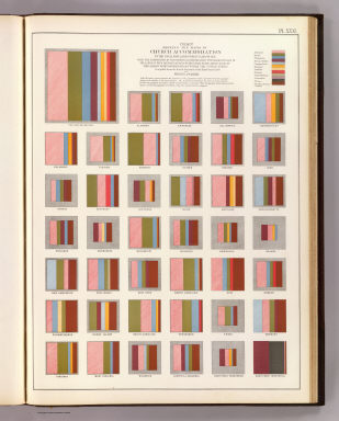
Chart showing the ratio of Church accommodation to the total population over 10 years of age with the proportion of such church accommodation furnished by each of the largest four denominations within each state and by each of the largest eight denominations within the United States. Compiled from the social statistics of the ninth census 1870. By Francis A. Walker. (Julius Bien, Lith., 1874)
Publisher
U.S.
Author
[United States. Census Office, Walker, Francis Amasa, 1840-1897]
Full Title
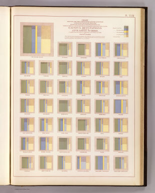
Chart showing for the United States and for each state with distinction of sex, the ratio between the total population over 10 years of age and the number of persons reported as engaged in each principal class of gainful occupations and also as attending school. Compiled from the returns of population at the ninth census 1870. By Francis A. Walker. (Julius Bien, Lith., 1874)
Publisher
U.S.
|