Who What Where WhenREMOVEWHATShow More |
Author
Melish, John
Full Title
Map of the American Coast, from Lynhaven Bay to Narraganset Bay, by John Melish.
Publisher
John Melish
Author
Melish, John
Full Title
Map of the Seat of War in North America. J. Melish del. H.S. Tanner, Dirext. Entered as the Art Directs, and Published by John Melish, Philadelphia.
Publisher
John Melish
Author
Melish, John
Full Title
Southern Section of the United States including Florida &c. by John Melish. Entered ... by John Melish ... 1 March 1813.
Publisher
John Melish
Author
Carey, Mathew
Full Title
(Title Page to) The General Atlas For Carey's Edition Of Guthrie's Geography improved ... Philadelphia: Published By Mathew Carey. May 1, 1795.
Publisher
Mathew Carey
Author
Carey, Mathew
Full Title
A Map of the United States: compiled chiefly from The State Maps, and other Authentic Information, by Saml. Lewis 1795. (with) inset map of Florida. W. Harrison Junr. Sculpt. Engraved for and sold by Matthew Carey Philadelphia.
Publisher
Mathew Carey
Author
Carey, Mathew
Full Title
(Title Page to) Carey's General Atlas ... Philadelphia: Published By Mathew Carey. May 1, 1796.
Publisher
Mathew Carey
Author
Rand McNally and Company
Full Title
Pennsylvania Railroad Great Trunk Line, and United States mail route ... copyright, 1881, by Rand, McNally & Co., Chicago ... (inset) Vicinity of Boston. (inset) Vicinity of New York and Philadelphia.
Publisher
Rand McNally & Co.
Author
Rand McNally and Company
Full Title
(Covers to) Pocket railroad map and business guide for Philadelphia, Pa., 1883, 1884.
Publisher
Rand McNally & Co.
Author
Rand McNally and Company
Full Title
(Text Page to) Pocket railroad map and business guide for Philadelphia, Pa., 1883, 1884.
Publisher
Rand McNally & Co.
Author
U.S. General Land Office
Full Title
Map of the United States and territories, with adjacent parts of Canada and Mexico also part of the West India islands, showing the extent of public surveys, Indian, military, and forest reservations, rail roads, canals, national parks and other details, compiled from official surveys of the General Land Office and other authentic sources. Under the direction of the Hon. Lewis A. Groff, Commissioner. A.F. Dinsmore, Chief, Draughting Division. 1890. Isaac Friedenwald, Photo. Litho. Balto. Md. (inset) Territory of Alaska.
Publisher
Isaac Friedenwald Photo Litho.
Author
[Andree, Richard, Scobel, Albert]
Full Title
Vereinigte Staaten von Nordamerika. Okt. 1905. (inset: nebenkarte) Hawaii-Inseln.
Publisher
Velhagen & Klasing
Author
[Central Pacific Railroad Company, Union Pacific Railroad Company]
Full Title
New map of the American Overland Route showing its connections, and land grants of 30,000,000 acres. Rand, McNally & Co., Chicago. (1879)
Author
[Andree, Richard, Scobel, Albert]
Full Title
Nordwestliche Vereinigte Staaten und Sudwestliches Canada. Mai 1905. Bearb. v. R. Kocher, u. E. Umbreit, Lithorgr. v. E. Gottschalck u. G. Kirchner. Flachentreue Azimut-Projektion (Hauptpunkt 38 (degree) n. Br., 96 (degree) w., L.).
Publisher
Velhagen & Klasing
Author
[Andree, Richard, Scobel, Albert]
Full Title
Sudwestliche Vereinigte Staaten und Nordliches Mexico. Mai 1905. Bearb. v. R. Kocher, u. E. Umbreit, Lithorgr. v. A. Wagner, M. grosse u. G. Kirchner. Flachentreue Azimut-Projektion (Hauptpunkt 38 (degree) n. Br., 96 (degree) w., L.). (inset: nebenkarte) Das Mittlere Mexico.
Publisher
Velhagen & Klasing
Author
[Andree, Richard, Scobel, Albert]
Full Title
Nordostliche Vereinigte Staaten und Suostdliches Canada. Mai 1905. Bearb. v. H. Mielisch, u. E. Umbreit, Lithorgr. v. R. Hennig, O. Kehr u. C. Muller. Flachentreue Azimut-Projektion (Hauptpunkt 38 (degree) n. Br., 96 (degree) w., L.). (inset: nebenkarte) Boston und Umgebung.
Publisher
Velhagen & Klasing
Author
[Andree, Richard, Scobel, Albert]
Full Title
Sudostliche Vereinigte Staaten, Cuba und Bahama - Inseln. Juni 1905. Bearb. v. A. Thomas, u. E. Umbreit, Lithorgr. v. H. Anschutz u. C. Muller. Flachentreue Azimut-Projektion (Hauptpunkt 38 (degree) n. Br., 96 (degree) w., L.). (inset: nebenkarte) Haiti und Porto Rico.
Publisher
Velhagen & Klasing
Author
[Andree, Richard, Scobel, Albert]
Full Title
Nordoststaaten der Nordamerikanischen Union. Marz 1905. Bearb. v. H. Mielisch u. E. Umbreit, Lithorgr. v. M. Grosse, O. Kehr u. G. Kirchner. Flachentreue Azimutaler Entwurf. (inset: nebenkarte) Gross-New York.
Publisher
Velhagen & Klasing
Author
[Central Pacific Railroad Company, Union Pacific Railroad Company]
Full Title
(Covers to) Union and Central Pacific Railroad Line. The Great American Over-land Route. Rand, McNally & Co., Printers, Engravers and Electrotypers, 77 and 79 Madison Street, Chicago.
Author
[Central Pacific Railroad Company, Union Pacific Railroad Company]
Full Title
(Text Page to) Union and Central Pacific Railroad Line. The Great American Over-land Route. Rand, McNally & Co., Printers, Engravers and Electrotypers, 77 and 79 Madison Street, Chicago.
Author
[New York Central Railroad Company, Rand McNally and Company]
Full Title
Map of the United States showing the New York Central Lines and connections ... Copyright, Rand McNally & Company. (inset map) Atlantic Ocean and surrounding countries. (inset map) The water level route, New York Central Lines. (1929)
Publisher
Rand McNally
Author
[New York Central Railroad Company, Rand McNally and Company]
Full Title
(Covers to) Map of the United States showing the New York Central Lines and connections ... Copyright, Rand McNally & Company. (with 2 inset maps). (1929)
Publisher
Rand McNally
Author
[New York Central Railroad Company, Rand McNally and Company]
Full Title
(Text Page to) Map of the United States showing the New York Central Lines and connections ... Copyright, Rand McNally & Company. (with 2 inset maps). (1929)
Publisher
Rand McNally
Author
Chicago, Burlington & Quincy Railroad Company
Full Title
(Text Page to) Burlington Route. United States map showing Burlington Lines and connections ...
Publisher
Poole Bros.
Author
[Missouri Pacific Railway Company, Rand McNally and Company]
Full Title
(Covers to) Missouri Pacific Ry. ... Rand, McNally & Co., Printers and Engravers, Chicago.
Publisher
Rand McNally
Author
[Missouri Pacific Railway Company, Rand McNally and Company]
Full Title
(Text Page to) Missouri Pacific Ry. ... Rand, McNally & Co., Printers and Engravers, Chicago.
Publisher
Rand McNally
Author
[Missouri Pacific Railway Company, Rand McNally and Company]
Full Title
Map of the South West Railway System. Missouri Pacific Ry., Central Branch U.P. R.R., Missouri, Kansas & Texas Ry. Texas and Pacific Ry., St. Louis, Iron Mountn. and Southern Ry., International and Great Northern R.R. and their connections. Copyright, 1883, by Rand, McNally & Co., Map Publishers, Chicago ...
Publisher
Rand McNally
Author
[Scovel, James L., O'Brien, Emmett J]
Full Title
Index Map. Locations are Approximate. (inset maps) Alaska, Hawaiian Islands, and Manat. (to accompany) Atlas of Landforms. James L Scovel; Emmett J O'Brien; J C McCormack, (Major); R.B. Chapman; Department of Earth, Space and Grafic Sciences; United States Military Academy, West Point, New York. John Wiley and Sons Inc., New York. London. Sydney.
Publisher
John Wiley & Sons Inc.
Author
Mitchell, Samuel Augustus
Full Title
Map of North America. 2. Philadelphia, Published By Charles Desilver, No. 714 Chesnut Street. Entered according to Act of Congress in the year 1859 by Charles Desilver in the Clerk's office if the District Court of the Eastern District of Pennsylvania.
Publisher
Charles Desilver.
Author
Mitchell, Samuel Augustus
Full Title
Canada East, formerly Lower Canada. 3. Philadelphia, Published By Charles Desilver, No. 714 Chesnut Street. Entered according to Act of Congress in the year 1856 by Charles Desilver in the Clerk's office if the District Court of the Eastern District of Pennsylvania.
Publisher
Charles Desilver.
Author
Mitchell, Samuel Augustus
Full Title
Canada West, formerly Upper Canada. Philadelphia, Published By Charles Desilver, No. 714 Chesnut Street. Entered according to Act of Congress in the year 1859 by Charles Desilver in the Clerk's office if the District Court of the Eastern District of Pennsylvania. 4.
Publisher
Charles Desilver.
Author
Mitchell, Samuel Augustus
Full Title
A New Map of the United States of America by J.H. Young. Philadelphia, Published By Charles Desilver, No. 1229 Chesnut Street. Entered according to Act of Congress in the year 1860 by Charles Desilver in the Clerk's office if the District Court of the Eastern District of Pennsylvania. 6. Engraved by J.L. Hazzard & E. Yeager.
Publisher
Charles Desilver.
Author
Debenham, Frank
Full Title
United States. (Copyright) G.P. Ltd.
Publisher
Simon and Schuster
Author
[Johnston, Alexander Keith, 1804-1871, Rogers, Henry Darwin]
Full Title
Geological map of the United States and British North America, constructed from the most recent documents & unpublished materials, for Keith Johnston's Physical atlas by Professor H.D. Rogers, Boston, U.S., 1855. Engraved & printed in colours by W. & A.K. Johnston. William Blackwood & Sons, Edinburgh & London. (1856)
Publisher
William Blackwood & Sons
Author
[Matthews-Northrup Division, J.W. Clement Co.]
Full Title
United States. Copyright, J.W. Clement Co., Matthews-Northrup Works, Buffalo, N.Y.
Publisher
World Publishing Company
Author
Stieler, Adolf
Full Title
Verein-Staaten Von Nord-America, Mexico, Yucatan U. A. Entw. u. gez. von Fr. v. Stulpnagel. Nachtr. bis 1873. Gestochen v. C. Metzeroth.
Publisher
Justus Perthes
Author
Rand McNally & Company
Full Title
Rand McNally Popular map of the United States. Copyright by Rand McNally & Company, Chicago. Made in U.S.A.
Publisher
Rand McNally & Company
Author
Johnston, Alexander Keith, 1804-1871
Full Title
The geographical distribution of health & disease, in connection chiefly with natural phenomena. (with) Fever districts of United States & W. Indies, on an enlarged scale. By A. Keith Johnston, F.R.S.E. &c. Engraved by W. & A.K. Johnston, Edinburgh. William Blackwood & Sons, Edinburgh & London. (1856)
Publisher
William Blackwood & Sons
Author
Stieler, Adolf
Full Title
Vereinigte Staaten Von Nord-Amerika In 6 Blattern, Bl. 1. Petermann. Bearbeitet v. H. Habenicht. Gest v. Metzeroth, Eberhardt, Kramer. Gotha: Justus Perthes 1872.
Publisher
Justus Perthes
Author
[Rand McNally and Company, State Farm Insurance Companies Travel Bureau]
Full Title
Rand McNally handy Railroad map United States. Copyright by Rand McNally & Company, Chicago. Made in U.S.A. (to accompany) State Farm Road Atlas: United States, Canada, Mexico,Central and South America. Copyright 1940 by Rand McNally & Company, Chicago, Ill.
Publisher
State Farm Insurance Companies Travel Bureau
Author
[Rand McNally and Company, State Farm Insurance Companies Travel Bureau]
Full Title
U.S. Air Mail and Air Express Routes. Copyright by Rand McNally & Company, Chicago. Made in U.S.A. (to accompany) State Farm Road Atlas: United States, Canada, Mexico,Central and South America. Copyright 1940 by Rand McNally & Company, Chicago, Ill.
Publisher
State Farm Insurance Companies Travel Bureau
Author
[Rand McNally and Company, State Farm Insurance Companies Travel Bureau]
Full Title
Rand McNally Road map, United States. Copyright by Rand McNally & Company, Chicago, Ill. Lithographed in the U.S.A. (to accompany) State Farm Road Atlas: United States, Canada, Mexico,Central and South America. Copyright 1940 by Rand McNally & Company, Chicago, Ill.
Publisher
State Farm Insurance Companies Travel Bureau
Author
[Rand McNally and Company, State Farm Insurance Companies Travel Bureau]
Full Title
Rand McNally Transcontinental Mileage Chart of the United States. Copyright by Rand McNally & Company, Chicago, Ill. Lithographed in the U.S.A. (insets) Mileage distance between principal cities, Yellowstone National Park, and Distant Chart. (to accompany) State Farm Road Atlas: United States, Canada, Mexico,Central and South America. Copyright 1940 by Rand McNally & Company, Chicago, Ill.
Publisher
State Farm Insurance Companies Travel Bureau
Author
Stieler, Adolf
Full Title
(Composite of) Die Vereinigten Staaten von Nord-Amerika in 6 Blattern im Maassstabe von 1:3.700.000. Von A. Petermann. Bearbeitet v. H. Habenicht. Gest v. Eberhardt, Kuhn, Metzeroth & Weiler. Gotha: Justus Perthes. 1873.
Publisher
Justus Perthes
Author
[Geographisches Institut (Weimar, Germany), Kiepert, Heinrich, 1818-1899]
Full Title
Die Vereinigten Staaten von Nord America nebst Canada. Neue berichtigte Ausgabe. Bearbeitet and gezeichnet von H. Kiepert. Situation und Schrift gestochen von C.J. Madel, Terrain von W. Weiler. Weimar, Verlag des Geographischen Instituts, 1855.
Publisher
Weimar Geo Inst.
Author
[Geographisches Institut (Weimar, Germany), Kiepert, Heinrich, 1818-1899, Weiland, C. F. (Carl Ferdinand), d. 1847]
Full Title
Die Vereinigten Staaten von Nord America mit Ausschluss von Texas und den westlichen Territorien, entworfen und gezeichnet von C.F. Weiland, berichtigt von H. Kiepert. Weimar, im Verlage des Geograph. Instituts, 1849. Gestochen v. Karl Madel.
Publisher
Weimar Geo Inst.
Author
[British Admiralty, Alden, James]
Full Title
N. America West Coast. San Francisco Harbour Surveyed by Lieut. James Alden U.S. Navy 1856. London. Published at the Admiralty 20th. Oct. 1860, under the Superintendence of Captn. Washington, R.N., F.R.S. Hydrographer. Corrections to Augt. 63 ... Engraved by J. & C. Walker. (with 4 profile views). (on lower right margin) 591.
Publisher
British Admiralty
Author
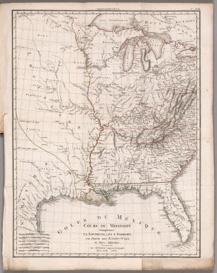
[Poirson, J.B., Herbin de Halle, Etienne de.]
Full Title
Cours du Mississippi comprenant la Louisiane, les 2 Florides, une partie des Etats-Unis et pays adjacents. Par J. B. Poirson, ingenieur geographe ; Nivose An XI (1803), grave par Tardieu l'aine rue de Sorbonne, no. 385. (on upper right margin) No.XVIII. (to accompany) Statistique Generale et Particuliere De La France et De Ses Colonies, avec une Nouvelle Description ... 1804.
Publisher
F. Buisson
Author
[Paullin, Charles O., Wright, John K.]
Full Title
Plate 2. Physical Geography and Vegetation. Relief; Soil Regions. Physical Divisions. Vegetation Regions.
Publisher
[Carnegie Institution of Washington, American Geographical Society of New York]
Author
[Paullin, Charles O., Wright, John K.]
Full Title
Plate 3. Forests; Growing Season. Area of Virgin Forest 1620. Area of Virgin Forest 1850. Area of Virgin Forest 1926. National Forest 1930. Average Length of Growing Season.
Publisher
[Carnegie Institution of Washington, American Geographical Society of New York]
Author
[Paullin, Charles O., Wright, John K.]
Full Title
Plate 4. Climate. Snow Cover. Droughts. Relative Humidity. Cloudiness. Pressure.
Publisher
[Carnegie Institution of Washington, American Geographical Society of New York]
|