Who What Where WhenREMOVEWHATShow More |
Author
Rand McNally and Company
Full Title
Viticulture in the United States, 1889. (Rand, McNally & Co., Engravers, Chicago, 1897)
Publisher
Rand McNally
Author
Rand McNally and Company
Full Title
Religious denominations in the United States, 1890. The creeds of the world. (Rand, McNally & Co., Engravers, Chicago, 1897)
Publisher
Rand McNally
Author
[Mitchell, Samuel Augustus, Young, James H.]
Full Title
(Covers to) Mitchell's Travellers Guide Through The United States. A Map Of The Roads, Distances, Steam Boat & Canal Routes &c. By J.H. Young. Philadelphia. Published by S. Augustus Mitchell. 1832. Engraved On Steel By J.H. Young And D. Haines. Entered ... 1832, by S. Augustus Mitchell ... Pennsylvania. (with 9 inset maps). (with folded sheet) Index. Steam-boat And Canal Routes ...
Publisher
S.A. Mitchell
Author
USSR (Union of Soviet Socialist Republics).
Full Title
(Map Title Page) 194-195. United States of America. 196. New York, Washington.
Publisher
USSR
Author
USSR (Union of Soviet Socialist Republics).
Full Title
194-195. United States of America. The World Atlas.
Publisher
USSR
Author
USSR (Union of Soviet Socialist Republics).
Full Title
(Map Title Page) 197-198. United States of America, North East. 199. New England.
Publisher
USSR
Author
USSR (Union of Soviet Socialist Republics).
Full Title
197-198. United States of America, North East. The World Atlas.
Publisher
USSR
Author
USSR (Union of Soviet Socialist Republics).
Full Title
(Map Title Page) 200-201. United States of America, North East Central. 202. West Pennsylvania and Ohio.
Publisher
USSR
Author
USSR (Union of Soviet Socialist Republics).
Full Title
200-201. United States of America, North East Central. The World Atlas.
Publisher
USSR
Author
USSR (Union of Soviet Socialist Republics).
Full Title
(Map Title Page) 203-204. United States of America, South East. 205. United States of America, Middle Atlantic.
Publisher
USSR
Author
USSR (Union of Soviet Socialist Republics).
Full Title
205. United States of America, Middle Atlantic. The World Atlas.
Publisher
USSR
Author
USSR (Union of Soviet Socialist Republics).
Full Title
(Map Title Page) 206-207. United States of America, South Central. 208. Illinois.
Publisher
USSR
Author
USSR (Union of Soviet Socialist Republics).
Full Title
(Map Title Page) 209-210. United States of America, West. 211. California.
Publisher
USSR
Author
[Mitchell, Samuel Augustus, Young, James H.]
Full Title
(Index to) Mitchell's Travellers Guide Through The United States. A Map Of The Roads, Distances, Steam Boat & Canal Routes &c. By J.H. Young. Philadelphia. Published by S. Augustus Mitchell. 1832. Engraved On Steel By J.H. Young And D. Haines. Entered ... 1832, by S. Augustus Mitchell ... Pennsylvania. (with 9 inset maps). (with folded sheet) Index. Steam-boat And Canal Routes ...
Publisher
S.A. Mitchell
Author
[Mitchell, Samuel Augustus, Young, James H.]
Full Title
Mitchell's Travellers Guide Through The United States. A Map Of The Roads, Distances, Steam Boat & Canal Routes &c. By J.H. Young. Philadelphia. Published by S. Augustus Mitchell. 1832. Engraved On Steel By J.H. Young And D. Haines. Entered ... 1832, by S. Augustus Mitchell ... Pennsylvania. (with 9 inset maps).
Publisher
S.A. Mitchell
Author
Colton, G.W.
Full Title
Colton's United States of America. Published By J. H. Colton. No. 172 William St. New York.
Publisher
J. H. Colton.
Author
[Mitchell, Samuel Augustus, Young, James H.]
Full Title
(Covers to) Mitchell's Reference & Distance Map Of The United States By J.H. Young. Published By S. Augustus Mitchell. Philadelphia For Sale By Mitchell & Hinman, No. 6 North Fifth Street 1834. Engraved by J.H. Young, F. Dankworth, E. Yeager & E. F. Woodward. Entered ... 1833 by S. Augustus Mitchell ... Pennsylvania ... (illustration) Designed by W. Mason. (inset) A General Map Of The United States with the contiguous British & Mexican Possessions. (with 12 additional inset maps).
Publisher
S.A. Mitchell
Author
[Mitchell, Samuel Augustus, Young, James H.]
Full Title
Mitchell's Reference & Distance Map Of The United States By J.H. Young. Published By S. Augustus Mitchell. Philadelphia For Sale By Mitchell & Hinman, No. 6 North Fifth Street 1834. Engraved by J.H. Young, F. Dankworth, E. Yeager & E. F. Woodward. Entered ... 1833 by S. Augustus Mitchell ... Pennsylvania ... (illustration) Designed by W. Mason. (inset) A General Map Of The United States with the contiguous British & Mexican Possessions. (with 12 additional inset maps).
Publisher
S.A. Mitchell
Author
Colton, G.W.
Full Title
Colton's United States of America. Published by G. W & C. B. Colton & Co., No. 172 William St. New York.
Publisher
G. W & C. B. Colton & Co.
Author
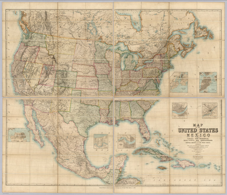
[Johnston, Alexander Keith, 1804-1871, Rogers, Henry Darwin, Stanford, Edward]
Full Title
(Covers to) Map Of The United States And Mexico With Canada, New Brunswick, Nova Scotia and Newfoundland, And Parts Of Central America & The West Indies. Constructed From State Documents & Unpublished Materials By Professor H.D. Rogers of Boston U.S. and A. Keith Johnston, F.R.S.E Geographer to the Queen. London; Published by Edward Stanford, 6 Charing Cross, S.W. May 13th. 1861. Additions to 1869.
Publisher
Edward Stanford
Author
Canada Government Railways
Full Title
Map Shewing the Railways of Canada to Accompany Annual Report on Railway Statistics. 1886. Collingwood Schreiber, Chief Engineer and General Manager of Government Railways. Office Of The Chief Engineer And General Manager Of Government Railways. Compiled by E.V. Johnson, M.C.S.C.E., In charge of Draughting Offices. Drawn by A.M. Edmonds. The Burland Lithographic Co. Montreal. (seal) Department Of Railways And Canals Canada. (in red) Railways Of Canada. In Operation And Under Construction. 31st December, 1886 ...
Publisher
Burland Lithographic Co.
Author
Canada Government Railways
Full Title
(Covers to) Map Shewing the Railways of Canada to Accompany Annual Report on Railway Statistics. 1886. Collingwood Schreiber, Chief Engineer and General Manager of Government Railways. Office Of The Chief Engineer And General Manager Of Government Railways. Compiled by E.V. Johnson, M.C.S.C.E., In charge of Draughting Offices. Drawn by A.M. Edmonds. The Burland Lithographic Co. Montreal. (seal) Department Of Railways And Canals Canada. (in red) Railways Of Canada. In Operation And Under Construction. 31st December, 1886 ...
Publisher
Burland Lithographic Co.
Author
Burr, David H., 1803-1875
Full Title
Map of the United States Of North America, By David H. Burr. Geographer to the House of Representatives of the U.S. . Entered ... 12th Jan. 1842, by David H. Burr ... District of Columbia.
Publisher
John Arrowsmith
Author
[Brue, Adrien Hubert, 1786-1832, Levasseur, E.]
Full Title
Carte de la Region Orientale des Etats-Unis et de la Dominion du Canada. Dresse par A. Brue, Geographe. Reoue par E. Levasseur, Membre de l'Institut, Institut Geographique de Paris. Ch. Delagrave. Editeur de la Societe de Geographie. 58 Rue des Ecoles. Atlas Universel en 67 feuilles No. 60. (inset) Partie Sud de la Floride. (inset) Ile de Terre-Neuve.
Publisher
Institut Geographique de Paris
Author
[Brue, Adrien Hubert, 1786-1832, Levasseur, E.]
Full Title
Carte Generale du Mexique, et de la partie Sud-Ouest Etats-Unis. Dresse par A. Brue, Geographe. Reoue par E. Levasseur, Membre de l'Institut, Institut Geographique de Paris. Ch. Delagrave. Editeur de la Societe de Geographie. 58 Rue des Ecoles. Carte de l'Amerique Centrale ou des Republicues de Guatemala, San Salvador, Honduras, Nicaragua, Costa Rica. Atlas Universel en 67 feuilles No. 61.
Publisher
Institut Geographique de Paris
Author
Rand McNally and Company
Full Title
Value of commerce of the United States with the principal foreign countries and geographical divisions of the world ... 1881 and 1891. Value of the leading articles of imports to and exports from the United States ... 1890 to ... 1891. Rand, McNally & Co., Engravers, Chicago. (1897)
Publisher
Rand McNally
Author
Smith, J. Calvin
Full Title
(Covers to) Special-Karte Der Vereinicten Staaten Von Nord-Amerika. von J. Calvin Smith. Zweite verbesserte Auflage. Map Of The United States of America By J. Calvin Smith. Cassel, Druck und Verlag von Theodor Fischer.
Publisher
Theodor Fischer
Author
Smith, J. Calvin
Full Title
(Title Page to) Special-Karte Der Vereinicten Staaten Von Nord-Amerika. von J. Calvin Smith. Zweite verbesserte Auflage. Map Of The United States of America By J. Calvin Smith. Cassel, Druck und Verlag von Theodor Fischer.
Publisher
Theodor Fischer
Author
Smith, J. Calvin
Full Title
(Kentucky, Tennessee, Mississippi, Alabama).
Publisher
Theodor Fischer
Author
Smith, J. Calvin
Full Title
(Virginia, North Carolina, South Carolina).
Publisher
Theodor Fischer
Author
Smith, J. Calvin
Full Title
(Texas, Louisiana).
Publisher
Theodor Fischer
Author
Smith, J. Calvin
Full Title
(United States, Mexico, Central America, Caribbean).
Publisher
Theodor Fischer
Author
Smith, J. Calvin
Full Title
(Composite of) United States. Special-Karte Der Vereinicten Staaten Von Nord-Amerika. von J. Calvin Smith. Zweite verbesserte Auflage. Map Of The United States of America By J. Calvin Smith. Cassel, Druck und Verlag von Theodor Fischer.
Publisher
Theodor Fischer
Author
Finley, Anthony
Full Title
Map of the United States Constructed from the Latest Authorities. 1827. Copyright secured. Published by A. Finley, Philada. Engraved by J.H. Young.
Publisher
Anthony Finley
Author
Galveston, Houston, & Henderson Railroad
Full Title
United States of America.
Publisher
King, Lith.
Author
Polish Army Topography Service
Full Title
United States of America. Pergamon World Atlas. Pergamon Press, Ltd. & P.W.N. Poland 1967. Sluzba Topograficzna W.P.
Publisher
Pergamon Press
Author
Polish Army Topography Service
Full Title
United States of America. Pergamon World Atlas. Pergamon Press, Ltd. & P.W.N. Poland 1967. Sluzba Topograficzna W.P.
Publisher
Pergamon Press
Author
Polish Army Topography Service
Full Title
United States of America. Pergamon World Atlas. Pergamon Press, Ltd. & P.W.N. Poland 1967. Sluzba Topograficzna W.P.
Publisher
Pergamon Press
Author
Polish Army Topography Service
Full Title
United States of America. Pergamon World Atlas. Pergamon Press, Ltd. & P.W.N. Poland 1967. Sluzba Topograficzna W.P.
Publisher
Pergamon Press
Author
Polish Army Topography Service
Full Title
United States of America - East. (inset) Washington (D.C.). Pergamon World Atlas. Pergamon Press, Ltd. & P.W.N. Poland 1967. Sluzba Topograficzna W.P.
Publisher
Pergamon Press
Author
Polish Army Topography Service
Full Title
United States of America. Pergamon World Atlas. Pergamon Press, Ltd. & P.W.N. Poland 1967. Sluzba Topograficzna W.P.
Publisher
Pergamon Press
Author
Polish Army Topography Service
Full Title
United States of America - Central. Pergamon World Atlas. Pergamon Press, Ltd. & P.W.N. Poland 1967. Sluzba Topograficzna W.P.
Publisher
Pergamon Press
Author
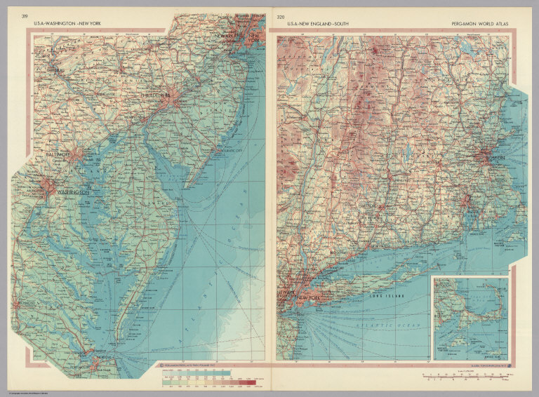
Polish Army Topography Service
Full Title
U.S.A. - Washington (D.C.) - New York. U.S.A. - New England - South. (inset) (Cape Cod - a continuation of main map). Pergamon World Atlas. Pergamon Press, Ltd. & P.W.N. Poland 1967. Sluzba Topograficzna W.P.
Publisher
Pergamon Press
Author
Polish Army Topography Service
Full Title
United States of America - West. Pergamon World Atlas. Pergamon Press, Ltd. & P.W.N. Poland 1967. Sluzba Topograficzna W.P.
Publisher
Pergamon Press
Author
Polish Army Topography Service
Full Title
United States of America - California. U.S.A. - Selected Areas. Atlantic Coastal Plain - Central. Pergamon World Atlas. Pergamon Press, Ltd. & P.W.N. Poland 1967. Sluzba Topograficzna W.P.
Publisher
Pergamon Press
Author
[Colton, J. H., Johnson, A.J.]
Full Title
Johnson's New Illustrated & Embellished County Map Of The Republics Of North America With The Adjacent Islands & Countries, Compiled Drawn & Engraved From U. States Land & Coast Surveys, British Admiralty & other Reliable Sources. Under the Direction of A.J. Johnson. Published by J.H. Colton, 172, William Street, New York, Edition For Johnson & Browning. Richmond VA. 1860. Entered ... 1860 by J.H. Colton ... New York. Map Designed by A.J. Johnson. Engraved by D.G. Johnson, J.H. Goldthwait, W.S. Barnard, Wm. Wright, G. Rae Smith, F.H. King, James Duthie, J.L. White. (inset) Map Of The World on Mercator's Projection ...
Publisher
Johnson & Browning
Author
[Butterfield, Carlos, Johnson & Browning]
Full Title
United States and Mexican Mail Steamship Line, and Statistics of Mexico. By Carlos Butterfield, Washington. December, 1859. New York: J.A.H. Hasbrouck & Co., Printers ... 1860. (on verso) Entered ... 1859, by Carlos Butterfield ... New York. (With) Map of the United States and Mexico Published by Johnson & Browning under the direction of Col. Carlos Butterfield. December 1859.
Publisher
J.A.H. Hasbrouck & Co.
Author
[Butterfield, Carlos, Johnson & Browning]
Full Title
(Title page to) United States and Mexican Mail Steamship Line, and Statistics of Mexico. By Carlos Butterfield, Washington. December, 1859. New York: J.A.H. Hasbrouck & Co., Printers ... 1860. (on verso) Entered ... 1859, by Carlos Butterfield ... New York. (With) Map of the United States and Mexico Published by Johnson & Browning under the direction of Col. Carlos Butterfield. December 1859.
Publisher
J.A.H. Hasbrouck & Co.
Author
Mitchell, Samuel Augustus
Full Title
Mitchell's New National Map Exhibiting The United States With The North American British Provinces, Sandwich Islands, Mexico And Central America, Together with Cuba and other West India Islands. Philadelphia, Published By S. Augustus Mitchell. 1858. Engraved by W. Williams, Map Engraver Philadelphia. Constructed And Engraved By W. Williams, 33 South Fifth St. Philadelphia. Entered ... 1856 by S. Augustus Mitchell ... Pennsylvania. (inset) Map Of The World On The Mercator Projection ... (inset) Map Of The World On The Globular Projection ... (inset) Map Of The Sandwich Islands.
Publisher
S. Augustus Mitchell
|