|
REFINE
Browse All : Images by Librairie Payot of Netherlands and Denmark and Great BritainAuthor
[Carey, H. C., Lea, I.]
Full Title
United States Of America. No. 5. Engraved by B. Tanner.
Publisher
H.C. Carey & I. Lea
Author
[Martin, R.M., Tallis, J. & F.]
Full Title
United States. The Illustrations by J. Marchant & Engraved by J. Rogers. The Map Drawn & Engraved by J. Rapkin.
Publisher
J. & F. Tallis
Author
Melish, John
Full Title
(Covers to) A Military and Topographical Atlas of the United States; Including The British Possessions & Florida ... By John Melish. Philadelphia, Published By John Melish. G. Palmer Printer 1815. (on verso) District of Pennsylvania ... fourteenth day of March ... 1815 ... John Melish ... hath deposited ... a book.
Publisher
John Melish
Author
Melish, John
Full Title
(Title Page to) A Military and Topographical Atlas of the United States; Including The British Possessions & Florida ... By John Melish. Philadelphia, Published By John Melish. G. Palmer Printer 1815. (on verso) District of Pennsylvania ... fourteenth day of March ... 1815 ... John Melish ... hath deposited ... a book.
Publisher
John Melish
Author
Melish, John
Full Title
Map of the Seat of War in North America. J. Melish del. H.S. Tanner, Dirext. Entered as the Art Directs, and Published by John Melish, Philadelphia.
Publisher
John Melish
Author
Melish, John
Full Title
Southern Section of the United States including Florida &c. by John Melish. 1816. Entered ... by John Melish ... 1 March 1813. Improved nth. June 1816.
Publisher
John Melish
Author
Melish, John
Full Title
Map of the River St. Lawrence and Adjacent Country From Williamsburg to Montreal from and Original Drawing in the War Department.
Publisher
John Melish
Author
Carver, Jonathan
Full Title
(Title Page to)Travels Through The Interior Parts Of North America, In The Years 1766, 1767, And 1768. By J. Carver, Esq. Captain Of A Company Of Provincial Troops During The Late War With France. Illustrated With Copper Plates, Coloured. The Third Edition. To which is added, Some Account Of The Author, And A Copious Index. London: Printed for C. Dilly, in the Poultry; H. Payne, in Pall-mall; and J. Phillips, in George-Yard, Lombard-Street. MDCCLXXXI. (with 2 maps).
Publisher
C. Dilly
Author
Carver, Jonathan
Full Title
A New Map of North America, From the Latest Discoveries. 1778. Engrav'd for Carvers Travels.
Publisher
C. Dilly
Author
Clemens, Rev E.J.
Full Title
(Box Cover to) Clemens' Silent Teacher. Dissected Map of the United States and of Each State in Counties. Manufactured by Rev. E.J. Clemens, Clayville, N.Y.
Publisher
Rev. E.J. Clemens
Author
Clemens, Rev E.J.
Full Title
Clemens' United States of America. Published by Rev. E.J. Clemens, Clayville, New York. (on reverse) Advertisement for Sherwin-Williams Paint with a picture of the factory in Cleveland, Ohio.
Publisher
Rev. E.J. Clemens
Author
Arrowsmith, Aaron
Full Title
(Covers to) A Map Of The United States Of North America Drawn from a number of Critical Researches By A. Arrowsmith, Hydrographer to H.R.H. the Prince of Wales. No. 10 Soho Square. London. Published as the Act Directs by A. Arrowsmith, No. 10 Soho Square. Jan 1st, 1796. Additions to 1802.
Publisher
A. Arrowsmith
Author
Arrowsmith, Aaron
Full Title
A Map Of The United States Of North America Drawn from a number of Critical Researches By A. Arrowsmith, Hydrographer to H.R.H. the Prince of Wales. No. 10 Soho Square. London. Published as the Act Directs by A. Arrowsmith, No. 10 Soho Square. Jan 1st, 1796. Additions to 1802.
Publisher
A. Arrowsmith
Author
Melish, John
Full Title
(Title Page to) Travels in the United States of America, in the years 1806 & 1807, and 1809, 1810 & 1811 ... Illustrated by eight maps. By John Melish. In two volumes. Philadelphia, printed for the author, and for sale by the different booksellers in the United States, and by Thomas & George Palmer, agents for the author. 1812. T. & G. Palmer, printers.
Publisher
Palmer, Thomas & George
Author
Melish, John
Full Title
Map of the United States of America. J. Melish del. H.S. Tanner Sc.
Publisher
Palmer, Thomas & George
Author
[Birkbeck, Morris, Melish, John]
Full Title
United States. Published 1st June 1816 by J. Melish. Philadelphia. Improved to 1818.
Publisher
M. Carey & Son
Author
Maclure, William
Full Title
(Title Page to) Observations on the Geology of the United States, explanatory of a Geological Map. By William Maclure. Read January 20th, 1809. (In) Transactions of the American Philosophical Society, Held at Philadelphia, for promoting Useful Knowledge. Volume VI. Published by C. and A. Conrad and Co. Philadelphia. ... Jane Aitken, Printer. 1809.
Publisher
C. & A. Conrad
Author
Maclure, William
Full Title
(Text Page to) Observations on the Geology of the United States, explanatory of a Geological Map. By William Maclure. Read January 20th, 1809. (In) Transactions of the American Philosophical Society, Held at Philadelphia, for promoting Useful Knowledge. Volume VI. Published by C. and A. Conrad and Co. Philadelphia. ... Jane Aitken, Printer. 1809.
Publisher
C. & A. Conrad
Author
Maclure, William
Full Title
A Map of the United States of America. By Samuel G. Lewis.
Publisher
C. & A. Conrad
Author
Imlay, Gilbert
Full Title
(Title Page to) A Topographical Description of the Western Territory of North America ... By Gilbert Imlay ... Illustrated with correct Maps of the Western Territory of North America; of the State of Kentucky, as divided into Counties, from actual Surveys by Elihu Barker; a Map of the Tenasee Government; and a Plan of the Rapids of the Ohio. The Third Edition With Great Additions. London: Printed For J. Debrett, Opposite Burlington House, Piccadilly. 1797.
Publisher
J. Debrett
Author
Morse, Jedidiah
Full Title
(Title Page to) The American Geography; or, A View of the Present Situation of the United States of America ... Illustrated with two Sheet Maps-One of the Southern, the other of the Northern States, neatly and elegantly engraved, and more correct than any that have hitherto been published ... By Jedidiah Morse. Elizabeth Town: Printed by Shepard Kollock, for the Author. M,DCC,LXXXIX.
Publisher
Shepard Kollock
Author
Bromme, Traugott
Full Title
(Cover to) Wegweiser Fur Einwanderer Und Reisende In Den Vereinigten Staaten Von Nord-Amerika Und Den Canada's. Eine Genaue Zusammenstellung aller Eisenbahn-, Post- und Dampfboot-Routen. von Traugott Bromme. Mit einer Karte. Bayreuth. Verlag der Buchner'schen Buchhandlung. 1848.
Publisher
Buchner
Author
Bromme, Traugott
Full Title
Die Vereinigten Staaten von Nord-America. Entworfen von J.E. Woerl. Lithographie von B. Herder in Freiburg im Breisgau.
Publisher
Buchner
Author
Gallatin, Albert
Full Title
(Title Page to) A Synopsis of the Indian Tribes Within the United States East of the Rocky Mountains, and in the British and Russian Possessions in North America. By the Hon. Albert Gallatin. (In: Archaeologia Americana. Transactions and Collections of the American Antiquarian Society. Vol II. Cambridge: Printed For The Society, At The University Press. 1836).
Publisher
The University Press
Author
Gallatin, Albert
Full Title
Map of the Indian Tribes of North America about 1600 A.D. along the Atlantic; & about 1800 A.D. westwardly. Published by the Amer: Antiq: Soc: From a drawing by Hon: A. Gallatin.
Publisher
The University Press
Author
Melish, John
Full Title
Map of the United States with the contiguous British & Spanish Possessions Compiled from the latest & best Authorities By John Melish. Engraved by J. Vallance & H.S. Tanner. Entered ... 16th day of June 1820. Published by James Finlayson Agent Philada. Successor to John Melish, Improved to 1823. (inset) West Indies.
Publisher
James Finlayson
Author
Maclure, William
Full Title
(Title Page to) Transactions of the American Philosophical Society. New Series. No. I. Observations on the Geology of the United States of North America; with Remarks on the probable Effects that may be produced by the Decomposition of the different Classes of Rocks on the Nature and Fertility of Soils: applied to the different States of the Union, agreeably to the accompanying geological Map. With two Copper Plates. By William Maclure. Read May 16th, 1817.
Publisher
A. Small
Author
Maclure, William
Full Title
Map of the United States of America. J. Melish del. Designed to illustrate the Geological Memoir of Wm. Maclure Esqr. Transactions American Philosophical Society, Vol. I. New Series. Entered ... and Published by John Melish, Philadelphia.
Publisher
A. Small
Author
Maclure, William
Full Title
(Title Page to) Observations on the Geology of the United States of America; With Some Remarks on the Effect Produced on the Nature and Fertility of Soils, By the Decomposition of the Different Classes of Rocks; And An Application to the Fertility of Every State in the Union, In Reference to the Accompanying Geological Map. With Two Plates. By William Maclure. ... Philadelphia: Printed for the Author, by Abraham Small ... 1817. (with) Essay On The Formation of Rocks, Or An Inquiry Into the Probable Origin of Their Present Form and Structure. By William Maclure. ... Philadelphia, Printed by John Wilbank ... 1838.
Publisher
A. Small
Author
Maclure, William
Full Title
United States of North America.
Publisher
A. Small
Author
[Churchman, Joseph and James, Moore, I.W.]
Full Title
(Title Page to) Rudiments of National Knowledge, Presented To The Youth Of The United States, And To Enquiring Foreigners. By A Citizen Of Pennsylvania. Philadelphia: Published by E.L. Carey & A. Hart. ... 1833.
Publisher
E.L. Carey & A. Hart
Author
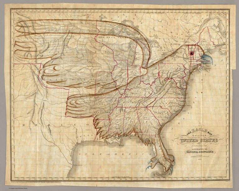
[Churchman, Joseph and James, Moore, I.W.]
Full Title
The Eagle Map of the United States Engraved for Rudiments of National Knowledge. 1833.
Publisher
E.L. Carey & A. Hart
Author
[Colton, G.W., Fisher, Richard Swainson]
Full Title
United States of America (physical). (inset) Hyetal or Rain Chart.
Publisher
J.H. Colton
Author
[Colton, G.W., Fisher, Richard Swainson]
Full Title
United States of America (political).
Publisher
J.H. Colton
Author
[Colton, G.W., Fisher, Richard Swainson]
Full Title
Chronological Chart of United States History.
Publisher
J.H. Colton
Author
[Johnson, A.J., Johnson, D. Griffing]
Full Title
Johnson's New Illustrated & Embellished County Map Of The Republics Of North America With The Adjacent Islands & Countries, Compiled Drawn & Engraved From U. States Land & Coast Surveys, British Admiralty & other Reliable Sources. By D. Griffing Johnson, New York & Washington. 1859. Entered ... 1856 by D.G. & A.J. Johnson ... New York. Map Designed by A.J. Johnson. Engraved by D.G. Johnson, J.H. Goldthwait, W.S. Barnard, Wm. Wright, G. Rae Smith, F.H. King, James Duthie, J.L. White. (inset) Johnson's Map Of The World on Mercator's Projection ...
Publisher
A.J. Johnson.
Author
Finley, Anthony
Full Title
United States. Young & Delleker Sc. Published by A. Finley Philada.
Publisher
Anthony Finley
Author
Johnson, A.J.
Full Title
Johnson's Massachusetts, Connecticut, and Rhode Island. (inset) Vicinity of Boston. Published by Alvin J. Johnson & Co., New York. 34. 35. Entered according to the Act of Congress, in the year 1864, by A.J. Johnson in the Clerk's Office of the District Court of the United States for the Southern District of New York.
Publisher
Alvin J. Johnson & Co.
Author
Rand McNally and Company
Full Title
Production of coal in the world, 1887 and 1890. Production of coal in the United States, 1889. Rand, McNally & Co., Engravers, Chicago. (1897)
Publisher
Rand McNally
Author
Rand McNally and Company
Full Title
Crop and per capita production, 1891, of the principal wheat-growing countries of the world. The cotton crop of the United States, season 1891-1893, by states. The cotton crop of the United States, 1882-3 to 1891-2. Rand, McNally & Co., Engravers, Chicago. (1897)
Publisher
Rand McNally
Author
Rand McNally and Company
Full Title
Value of the exports from the United States, classified ... between 1860 and 1891. Value of the leading products of agriculture exported from the United States ... between 1860 and 1891. Value of imports by geographical divisions ... 1890 to ... 1891. Value of imports ... into the United States ... 1888 to 1891 ... Rand, McNally & Co., Engravers, Chicago. (1897)
Publisher
Rand McNally
Author
Johnson, A.J.
Full Title
Johnson's United States. Published by Alvin J. Johnson & Co., New York. 28. 29. Entered according to the Act of Congress, in the year 1864, by A. J. Johnson in the Clerk's Office of the District Court of the United States for the Southern District of New York.
Publisher
Alvin J. Johnson & Co.
Author
Carey, Mathew
Full Title
Map of the United States of America. Gridley Sc.
Publisher
M. Carey and Son
Author
Rand McNally and Company
Full Title
Rand, McNally & Co.'s indexed atlas of the world map of Montreal. Copyright, 1893, by Rand, McNally & Co. (Chicago, 1897)
Publisher
Rand McNally
Author
Rand McNally and Company
Full Title
(Covers to) Rand, McNally & Co.'s indexed atlas of the world containing large scale maps of every country and civil division upon the face of the globe, together with historical, descriptive, and statistical matter relative to each ... Accompanied by a new and original compilation forming a ready reference index ... Engraved, printed and published by Rand, McNally & Company, Chicago and New York, U.S.A., 1897. (vol. 2) United States.
Publisher
Rand McNally
Author
Carey, Mathew
Full Title
Missouri Territory formerly Louisiana. Bower, Sc.
Publisher
M. Carey and Son
Author
Rand McNally and Company
Full Title
(Title Page to) Rand, McNally & Co.'s indexed atlas of the world containing large scale maps of every country and civil division upon the face of the globe, together with historical, descriptive, and statistical matter relative to each ... Accompanied by a new and original compilation forming a ready reference index ... Engraved, printed and published by Rand, McNally & Company, Chicago and New York, U.S.A., 1897. (Vol. 2 United States)
Publisher
Rand McNally
Author
Rand McNally and Company
Full Title
(Title Page Verso to) Rand, McNally & Co.'s indexed atlas of the world containing large scale maps of every country and civil division upon the face of the globe, together with historical, descriptive, and statistical matter relative to each ... Accompanied by a new and original compilation forming a ready reference index ... Engraved, printed and published by Rand, McNally & Company, Chicago and New York, U.S.A., 1897. (verso) Copyright, 1894, by Rand, McNally & Co., Chicago. (vol. 2 United States)
Publisher
Rand McNally
Author
Rand McNally and Company
Full Title
(Contents to) Rand, McNally & Co.'s indexed atlas of the world containing large scale maps of every country and civil division upon the face of the globe, together with historical, descriptive, and statistical matter relative to each ... Accompanied by a new and original compilation forming a ready reference index ... Engraved, printed and published by Rand, McNally & Company, Chicago and New York, U.S.A., 1897.
Publisher
Rand McNally
|