Browse All

1875 Agricultural productions colored by grad … State Atlas Agricultural productions colored by grad … |

1875 Vital statistics, United Census, 1870: D … State Atlas Vital statistics, United Census, 1870: D … |

1884 Distribution of the Genera Carya & Umbel … Physical Atlas Map Showing the Distribution of the Gene … |

1884 Distribution of the Genus Juglans [The W … Physical Atlas Map Showing the Distribution of the Genu … |

1884 Distribution of the Genera Castanea & Ca … Physical Atlas Map Showing the Distribution of the Gene … |

1884 Distribution of Liriodendron Tulipifera … Physical Atlas Map Showing the Distribution of Lirioden … |

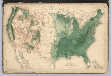
1884 Distribution of Prosopsis Juliflora, Que … Physical Atlas Map Showing the Distribution of Prosopsi … |
1884 United States showing the Relative Avera … Physical Atlas Map of the United States showing the Rel … |

1872 Covers: Atlases of the United States, Il … [National Atlas, State Atlas] (Covers to) Atlas of Whiteside Co. and t … |

1872 Title Page: Atlases of the United States … [National Atlas, State Atlas] (Title Page to) Atlas of Whiteside Co. a … |

1872 Table of Contents: Atlases of the United … [National Atlas, State Atlas] (Table of Contents to) Atlas of Whitesid … |

1872 Text: List of Post Offices in Illinois. … [National Atlas, State Atlas] (Text Page) List of Post Offices in Illi … |

1867 Title Page: Report, Commissioner, Genera … Gov't Report Book (Title Page to) Report of the Commission … |

1872 Map of the United States. [National Atlas, State Atlas] Map of the United States. Warner & Beers … |

1872 Atlas of the United States, New England, … [National Atlas, State Atlas] Atlas of the United States, New England, … |

1872 Atlas of the United States, Map of the C … [National Atlas, State Atlas] Atlas of the United States, Map of the C … |

1872 Atlas of the United States, Map of the W … [National Atlas, State Atlas] Atlas of the United States, Map of the W … |

1872 Atlas of the United States, Map of the S … [National Atlas, State Atlas] Atlas of the United States, Map of the S … |

1867 Map of the United States and Territories … Gov't Report Book Map of the United States and Territories … |

1876 United States and Territories. County Atlas Map of the United States and Territories … |

1862 Composite: Colton's New Railroad & Count … Case Map (Composite of) Colton's New Railroad & C … |

1876 Map of the United States. State Atlas Map of the United States. 1876. (Publish … |

1874 United States and Territories together w … County Atlas Map of the United States and Territories … |

1825 Cover: Map, United States of North Ameri … Case Map (Covers to) Map Of The United States Of … |

1876 United States. County Atlas Map of the United States. |

1876 Climatological and Geological Maps of th … County Atlas Climatological Map of the United States. … |

1825 Map of the United States Of North Americ … Case Map Map Of The United States Of North Americ … |

1825 Cover: United States roads, canals, stea … Guide Book (Covers to) The Traveller's Guide. A Map … |

1814 United States School Atlas United States. (engraved by) H.S. Tanner … |

1814 Text Page: Study Of United States, Of En … School Atlas (Text Pageto) Of The United States (and) … |

1814 Text Page: Study Of England And Wales School Atlas (Text Pageto) Of England And Wales. (to … |

1825 A Map Of The Roads, Canals And Steam Boa … Guide Book The Traveller's Guide. A Map Of The Road … |

1814 Index Page: Table Of The Principal Place … School Atlas (Index Page to) Table Of The Principal P … |

1814 Index Page: List Of Post Towns In The Un … School Atlas (Index Page to) List Of Post Towns. (to … |

1814 Index Page: List Of Post Towns In The Un … School Atlas (Index Page to) List Of Post Offices. (t … |

1814 Index Page: List Of Post Towns In The Un … School Atlas (Index Page to) List Of Post Towns. (to … |

1814 Index Page: List Of Post Towns In The Un … School Atlas (Index Page to) List Of Post Towns. (to … |

1814 Index Page: List OF Post Towns In The Un … School Atlas (Index Page to) List Of Post Towns. (to … |

1814 Index Page: List Of Post Towns In The Un … School Atlas (Index Page to) List Of Post Towns. (to … |

1828 United States And British Provinces School Atlas United States And British Provinces. (en … |

1821 United States School Atlas United States. Engraved by A. Willard & … |

1885 United States. County Atlas Map of the United States. Copyright 1884 … |

1845 Physical Map Of The United States. School Atlas Physical Map Of The United States. Adapt … |

1845 Political Map Of The United States, Mexi … School Atlas Political Map Of The United States, Mexi … |

1845 Physical & Political Map Of The North Ea … School Atlas Physical & Political Map Of The N. Easte … |

1845 Political Map Of the Northern Division O … School Atlas Political Map Of the Northern Division O … |

1829 United States of America. Case Map United States of America: by H.S. Tanner … |

1845 Political Map Of the Southern Division O … School Atlas Physical & Political Map Of the Southern … |

1870 United States. World Atlas Johnson's United States. |

1829 Cover: United States of America. Case Map (Covers to) United States of America: by … |