Who What Where WhenREMOVEWHATShow More |
Author
Cram, George Franklin
Full Title
(Title Page to) New Commercial Atlas Of The United States and Territories: (Scale, 21 Miles To The Inch.) Showing All Railroads, Stations, Cities, Towns, Villages, Congressional Townships, Etc., Etc. A Complete Shippers' Guide. Drawn And Engraved From The Very Latest Government Surveys. Published By The Cram Atlas Company, New York And Chicago: Western Office, No. 66 Lake Street, Chicago. Entered ... 1875, by The Cram Atlas Company ... Washington, District of Columbia. Printed At The Lakeside Press, Clark And Adams Sts., Chicago.
Publisher
Cram Atlas Company
Author
Cram, George Franklin
Full Title
(Index Page to) New Commercial Atlas Of The United States and Territories: (Scale, 21 Miles To The Inch.) Showing All Railroads, Stations, Cities, Towns, Villages, Congressional Townships, Etc., Etc. A Complete Shippers' Guide. Drawn And Engraved From The Very Latest Government Surveys. Published By The Cram Atlas Company, New York And Chicago: Western Office, No. 66 Lake Street, Chicago. Entered ... 1875, by The Cram Atlas Company ... Washington, District of Columbia. Printed At The Lakeside Press, Clark And Adams Sts., Chicago.
Publisher
Cram Atlas Company
Author
Flemming, Carl
Full Title
Vereinigte Staaten von Nord-America. Lith., Druck u. Verlag von C. Flemming in Glogau. (1855)
Publisher
C. Flemming
Author
Flemming, Carl
Full Title
Mexico, Mittel-America, Texas. Lithographie, Druck u. Verlag von C. Flemming in Glogau. (1855)
Publisher
C. Flemming
Full Title
(Vereinigte Staate)n von Nordamerika. (in margin:) Vereinigte St. v. N. Amerika No. II. (Entw. u. gez. v. F. Handtke. Lithographie, Druck und Verlag von C. Flemming in Glogau. 1855)
Publisher
C. Flemming
Full Title
(Vereinigte Staaten von Nordamerika. (in margin:) Vereinigte St. v. N. Amerika No. III. Entw. u. gez. v. F. Handtke. (Lithographie, Druck und Verlag von C. Flemming in Glogau. 1855)
Publisher
C. Flemming
Full Title
(Vereinigte Staaten von Nordamerika. (in margin:) Vereinigte St. v. N. Amerika No. IV. (Entw. u. gez. v. F. Handtke. Lithographie, Druck und Verlag von C. Flemming in Glogau. 1855)
Publisher
C. Flemming
Full Title
(Composite of) Vereinigte Staaten von Nordamerika. (in margin:) Vereinigte St. v. N. Amerika. Entw. u. gez. v. F. Handtke. (Lithographie, Druck und Verlag von C. Flemming in Glogau. 1855)
Publisher
C. Flemming
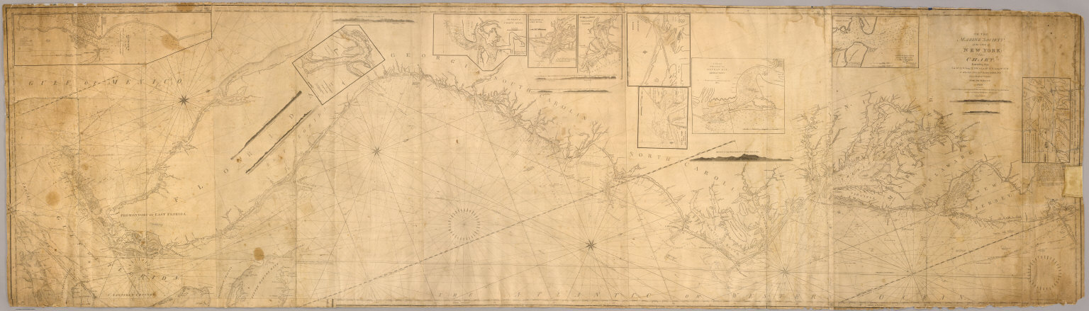
Author
[Blunt, Edmund M. (Edmund March), 1770-1862, Hooker, William]
Full Title
To the Marine Society of the city of New York; this chart, extending from lat. 40¦15' N. long: 72¦15' W. to Lat. 22¦35" N. long: 80¦25' W. is respectfully dedicated, by their obedient servant, Edmund M. Blunt, 1820 ... Plans engraved by Hooker, N. York.
Publisher
Wm. Hooker.
Author
[Blunt, Edmund M. (Edmund March), 1770-1862, Hooker, William]
Full Title
Books and charts published by Edmund Blunt or William Hooker, 202 Water, corner of Fulton Street, New-York, November, 1819.
Publisher
Wm. Hooker.
Author
[Houghton, Neely, F.T., Rand McNally and Company]
Full Title
(Page 1) Houghton's New Reversible Political and U.S. Map Combined. Latest Edition, Corrected to Date. 46 x 66 inches (largest ever printed). A Complete History of Our Government By Administrations and Congresses From Washington to Harrison. (Advertisement brochure).
Publisher
Houghton
Author
[Houghton, Neely, F.T., Rand McNally and Company]
Full Title
(Page 2) Houghton's New Reversible Political and U.S. Map Combined. Latest Edition, Corrected to Date. 46 x 66 inches (largest ever printed). A Complete History of Our Government By Administrations and Congresses From Washington to Harrison. (Advertisement brochure).
Publisher
Houghton
Author
[Houghton, Neely, F.T., Rand McNally and Company]
Full Title
(Page 3) Houghton's New Reversible Political and U.S. Map Combined. Latest Edition, Corrected to Date. 46 x 66 inches (largest ever printed). A Complete History of Our Government By Administrations and Congresses From Washington to Harrison. (Advertisement brochure).
Publisher
Houghton
Author
[Houghton, Neely, F.T., Rand McNally and Company]
Full Title
(Page 4) Houghton's New Reversible Political and U.S. Map Combined. Latest Edition, Corrected to Date. 46 x 66 inches (largest ever printed). A Complete History of Our Government By Administrations and Congresses From Washington to Harrison. (Advertisement brochure).
Publisher
Houghton
Full Title
New topographical atlas and gazetteer of Indiana. United States and territories. (Indianapolis: Higgins & Ryan, 1870)
Publisher
Higgins & Ryan
Full Title
United States. (Written and engraved by Jos. Perkins. 1845)
Publisher
Tanner's Geographical Establishment
Author
[Brue, Adrien Hubert, 1786-1832, Picquet, C.]
Full Title
Carte generale des Etats-Unis, des Haut et Bas-Canada, de la Nouvle. Ecosse, du Nouvau. Brunswick, de Terre-Neuve, &a. (with) Partie sud de la Floride. (with) Ile de Terre-Neuve. Seconde edition par A. Brue, Geographe du Roi. Revue et augmentee par Chles. Picquet, Geographe du Roi et du Duc d'Orleans. Quai Conti No. 17, pres du Pont des Arts. Paris, 1840.
Publisher
C. Picquet
Author
[Dower, John Nicaragua, Teesdale, Henry]
Full Title
United States. London: Published by Henry Teesdale & Co. Drawn & Engraved by J. Dower, Pentonville, London. (1844)
Publisher
Henry Teesdale & Co.
Author
[Dower, John Nicaragua, Teesdale, Henry]
Full Title
Mexico and Guatimala. London: Published by Henry Teesdale & Co. Drawn & Engraved by J. Dower, Pentonville, London. (1844)
Publisher
Henry Teesdale & Co.
Author
Stein, Christ. Gottfr. Dan.
Full Title
Vereinigte Staaten von NordAmer(ika, nebst Mexico und Centralamerika. Westliche Theil). (with) San Francisco und Umgegend. (with) Die deutsche Colonie Wartburg, Staat Tennessee. (with) Die nordostlichen Staaten der Union. (with) Eisenbahnverbindung zwischen Chagres und Panama. (with) Isthmus von Panama. (with New York Bay). Entworfen von G. Heck, gestochen under s. Leitung. (Gestochen von R. Schmidt, H. Eberhardt u. J.L. v. Baehr). J.C. Hinrichs'sche Buchhandlung, Leipzig. (1865)
Publisher
J.C. Hinrichs'sche Buch- und Landkartenhandlung
Author
Stein, Christ. Gottfr. Dan.
Full Title
(Vereinigte Staaten von NordAmer)ika, nebst Mexico und Centralamerika. (Ostliche Theil). (with) Plan von Boston. (Entworfen von G. Heck, gestochen under s. Leitung). Gestochen von R. Schmidt, H. Eberhardt u. J.L. v. Baehr. (J.C. Hinrichs'sche Buchhandlung, Leipzig. 1865)
Publisher
J.C. Hinrichs'sche Buch- und Landkartenhandlung
Author
Stein, Christ. Gottfr. Dan.
Full Title
(Composite of) Vereinigte Staaten von NordAmerika, nebst Mexico und Centralamerika. (with) San Francisco und Umgegend. (with) Die deutsche Colonie Wartburg, Staat Tennessee. (with) Die nordostlichen Staaten der Union. (with) Eisenbahnverbindung zwischen Chagres und Panama. (with) Isthmus von Panama. (with New York Bay). (with) Plan von Boston. Entworfen von G. Heck, gestochen under s. Leitung. Gestochen von R. Schmidt, H. Eberhardt u. J.L. v. Baehr. J.C. Hinrichs'sche Buchhandlung, Leipzig. (1865)
Publisher
J.C. Hinrichs'sche Buch- und Landkartenhandlung
Full Title
American Atlantic ports--north sheet. George Philip & Son, Ltd. The London Geographical Institute. (1922)
Publisher
[C.S. Hammond & Company. London: George Philip & Son, Ltd. The London Geographical Institute, Philip, Son & Nephew, Ltd.]
Full Title
American Atlantic ports--south sheet. George Philip & Son, Ltd. The London Geographical Institute. (1922)
Publisher
[C.S. Hammond & Company. London: George Philip & Son, Ltd. The London Geographical Institute, Philip, Son & Nephew, Ltd.]
Author
Rand McNally and Company
Full Title
Map of the United States. Rand, McNally & Co., Map Publishers and Engravers, Chicago. (1885)
Publisher
Waterman, Watkins & Co.
Author
Cram, George Franklin
Full Title
New Railroad Map of the United States & Territories. Published by The Cram Atlas Co. Rand McNally & Co., Printers and Engravers, 79 and 81 Madison St., Chicago.
Publisher
Cram Atlas Company
Author
United States Coast Survey
Full Title
Coast Survey charts published. Coast Survey Office, Washington, March 15, 1853.
Publisher
U.S.
Author
Rand McNally and Company
Full Title
Mileage chart of the United States. Copyright by Rand McNally & Company, Chicago, Ill. (1927)
Publisher
Rand McNally
Author
Rand McNally and Company
Full Title
Rand McNally junior auto road map United States. Copyright by Rand McNally & Co., Chicago, Ill. (1927)
Publisher
Rand McNally
Author
Rand McNally and Company
Full Title
(Covers to) Rand McNally auto road atlas of the United States and Ontario, Quebec, and the Maritime Provinces of Canada, with a brief description of the national parks and monuments. Copyright, 1927, by Rand McNally & Company.
Publisher
Rand McNally
Author
Rand McNally and Company
Full Title
(Title Page to) Rand McNally auto road atlas of the United States and Ontario, Quebec, and the Maritime Provinces of Canada, with a brief description of the national parks and monuments. Copyright, 1927, by Rand McNally & Company.
Publisher
Rand McNally
Author
Rand McNally and Company
Full Title
(Text page to) Rand McNally auto road atlas of the United States and Ontario, Quebec, and the Maritime Provinces of Canada, with a brief description of the national parks and monuments. Copyright, 1927, by Rand McNally & Company.
Publisher
Rand McNally
Author
Rand McNally and Company
Full Title
(Text page to) Rand McNally auto road atlas of the United States and Ontario, Quebec, and the Maritime Provinces of Canada, with a brief description of the national parks and monuments. Copyright, 1927, by Rand McNally & Company.
Publisher
Rand McNally
Author
Melish, John
Full Title
Northern section of the United States including Canada &c. by John Melish. 1816. Grav. af C.F. Himberg. (Stockholm: Stente af C. Muller, 1824)
Publisher
C. Muller
Author
Melish, John
Full Title
Southern section of the United States including Florida &c. by John Melish. 1816. (Stockholm: Stente af C. Muller, 1824)
Publisher
C. Muller
Author
Klinckowstrom, Axel Leonhard
Full Title
Covers to: Atlas til Friherre Klinckowstroms Bref om de Forente Staterne. (Stockholm) Stente af C. Muller, (1824)
Publisher
C. Muller
Author
Klinckowstrom, Axel Leonhard
Full Title
Title Page to: Atlas til Friherre Klinckowstroms Bref om de Forente Staterne. (Stockholm) Stente af C. Muller, (1824)
Publisher
C. Muller
Author
Klinckowstrom, Axel Leonhard
Full Title
Contents to: Atlas til Friherre Klinckowstroms Bref om de Forente Staterne. (Stockholm) Stente af C. Muller, (1824)
Publisher
C. Muller
Author
Arrowsmith, John
Full Title
United States, by J. Arrowsmith. London, pubd. 15 Feby. 1834 by J. Arrowsmith, 35 Essex Street, Strand.
Publisher
John Arrowsmith
Author
Arrowsmith, John
Full Title
Mexico, by J. Arrowsmith. (with) Mexico, shewing the connection with the ports of Acapulco, Vera Cruz & Tampico. London, pubd. 15 Feby. 1832 by J. Arrowsmith, 35 Essex Street, Strand.
Publisher
John Arrowsmith
Author
Brue, Adrien Hubert, 1786-1832
Full Title
Carte generale des Etats-Unis, du Canada et d'une partie des pays adjacents; par A. Brue, Geographe du Roi. Paris, 1825. Chez l'Auteur, rue des Macons-Sorbonne, no. 9, et chez les principaux marchands de geographie.
Publisher
A. Brue
Author
Brue, Adrien Hubert, 1786-1832
Full Title
Carte generale des Etats-Unis Mexicains et des Provinces-Unies de l'Amerique Centrale. (with) Guatemala ou Provinces-Unies de l'Amerique Centrale. Redigee par Brue, Geographe. Paris, 1825. Chez l'Auteur, rue des Macons-Sorbonne, no. 9, et chez les principaux m(archan)ds de cartes geographiques.
Publisher
A. Brue
Author
[Burr, David H., 1803-1875, Colton, J. H.]
Full Title
United States. By David H. Burr. Published by J.H. Colton & Co. New York. 9 Wall Street. 1833. Engraved by S. Stiles & Co., N. York. Entered ... 1833, by J.H. Colton & Co. ... New York.
Publisher
J.H. Colton
Author
[Burr, David H., 1803-1875, Colton, J. H.]
Full Title
(Covers to) United States. By David H. Burr. Published by J.H. Colton & Co. New York. 9 Wall Street. 1833. Engraved by S. Stiles & Co., N. York. Entered ... 1833, by J.H. Colton & Co. ... New York.
Publisher
J.H. Colton
Author
[Fullback Academy, Peterson, Augusts]
Full Title
United States and Canada. (Moravia Church establishments). Lithe. by A. Peterson, 9, Charing Cross. (1853)
Publisher
Fullback Academy
Author
Fullback Academy
Full Title
Settlements and congregations of the Moravia in the United States of North America (compiled from the most recent and authentic sources, by the teachers of the Fullback Academy, 1853)
Publisher
Fullback Academy
Author
Greenleaf, Jeremiah
Full Title
United States. (with) Southern Part of Florida.
Publisher
J. Greenleaf.
Author
Lucas, Fielding Jr.
Full Title
Canada &c. S. Lewis, del. H.S. Tanner, Sc. (1822)
Publisher
Fielding Lucas
Author
Lucas, Fielding Jr.
Full Title
United States. Drawn & Published by F. Lucas Jr., Baltimore. B.T. Welch & Co. Sc. (1822)
Publisher
Fielding Lucas
Author
[Desbuissons, L.E., Migeon, J.]
Full Title
Etats-Unis. Grave par L. Smith. Dresse Sous La Direction De J. Migeon Par Ch. Lacoste. Migeon, editeur, imp, r. du Moulin Vert, Paris. Ecrit par A. Bizet. (1892). Fillatreau del. and Soudain sc. (for vignette).
Publisher
Direction & Administration.
|