Who What Where WhenREMOVEWHATShow More |
Author
Siraut - Destouches, A.
Full Title
Siraut - Destouches - [1780?]. Kaart van de Rivier en Colonie Essequebo ... S Doc 91 55 2. 67. Map of the Essequibo Colony, 1779 or 1780; Probably by A. Siraut - Destouches, Colonial Surveyor. Reproduced from the Original Manuscript, Bought, in 1898, in Holland for the Commission. Photo. Lith. by A. Hoen & Co., Baltimore, MD.
Publisher
United States of America
Author
Chollet, L.
Full Title
Chollet? - 1791 or earlier. S Doc 91 55 2. 68. Map of the Coast Region of the Essequibo Colony; Probably Identical with that Transmitted to the West India Company by L. Chollet, Colonial Surveyor, 1791. Reproduced from the Original Manuscript Bought, in 1896, in Holland, for the Commission. Photo. Lith. by A. Hoen & Co., Baltimore, MD.
Publisher
United States of America
Author
Chollet, L.
Full Title
Chollet - 1794. S Doc 91 55 2. 69. Map of the Pomeroon Coast Region, Surveyed for the Dutch Government by the Colonial Surveyors van de Burght and Chollet, and Charted by the Latter, 1794. Reproduced from the Autograph Original in the Rijksarchief at the Hague, (No. 1545 of Catalogue). Photo. Lith. by A. Hoen & Co., Baltimore, MD.
Publisher
United States of America
Author
Bouchenroeder, F. Von
Full Title
Bouchenroeder - 1796. S Doc 91 55 2. 70. Generaale en Speciaale Kaart der Colonien van de Republicq de Vereenigde Nederlanden Geleegen in Guayana .... Map of the Colonies of Essequibo and Demerara; by Major F. v. Bouchenroeder, 1796. Reproduced from the Autograph Manuscript in the Rijksarchief at the Hague, No. 1489 of the Catalogue. Photo. Lith. by A. Hoen & Co., Baltimore, MD.
Publisher
United States of America
Author
Surville, Luis de
Full Title
Surville - 1778. S Doc 91 55 2. 71. Mapa Cooro-Grafico de la Nueva Andalucia ... 1778. Map of the Spanish Province of Nueva Andalucia made at the Order of the Head of the Spanish Archive of the Indies by Luis de Surville, Assistant Archivist, 1778. Reproduced from teh Original in Caulin's Historia de la Nueva Andalucia, Madrid, 1779. Photo. Lith. by A. Hoen & Co., Baltimore, MD.
Publisher
United States of America
Author
Anonymous
Full Title
Anonymous - [1735?]. S Doc 91 55 2. 72. Sketch Map of the Capuchin Missions in the Province of Guayana about 1765. Map I. Reproduced by Photo-lithography from the Original in the Capuchin Archives in Rome. Sketch Map of the Missions of the Catalonian Capuchins in the Spanish Province of Guayana, about 1735 (Rather than 1765). Reproduced from a Photolithographic Facsimile of the Manuscript Original in the Archives of the Capuchin Order at Rome given by Father Joseph Strickland, S.J., in his Documents nad Maps on the Boundary Question between Venzuela and British Guyana, Rome, 1898. Photo. Lith. by A. Hoen & Co., Baltimore, MD.
Publisher
United States of America
Author
Strickland, Joseph
Full Title
Fr. Carlos de Barcelona - 1771. S Doc 91 55 2. 73. Sketch Map of the Carpuchiin Missions in the Province of Guyana about 1771. Map II. Sketch Map of the Missions of the Catalonian Capuchins iin the Spanish Province of Guayana, 1771. Reproduced from a Photolithographic Facsimile of the Manuscript Original in the Archives of the Capuchin Order at Rome given by Father Joseph Strickland, S.J., in his Documents and Maps on the Boundary Question between Venezuela and British Guayana, Rome, 1898. Photo. Lith. by A. Hoen & Co., Baltimore, MD.
Publisher
United States of America
Author
Barcelona, Carlos de
Full Title
Fr. Carlos de Barcelona - [1779?]. S Doc 91 55 2. 74. Sketch Map of the Capuchin Missions in Guayana about 1779. Map III. Sketch Map of the Missions of the Catalonia Capuchins in the Spanish Province of Guayana, [1779?]. Reproduced from a Photolithographic Facsimile of the Manuscript Original in the Archives of the Capuchin Order at Rome given by Father Joseph Strickland, S.J., in his Documents and Maps on the Boundary Question between Venezuela and British Guayana, Rome, 1898. Photo. Lith. by A. Hoen & Co., Baltimore, MD.
Publisher
United States of America
Author
Strickland, Joseph
Full Title
Anonymous - [1789?]. S Doc 91 55 2. 75. Sketch Map of the Capuchin Missions in the Province of Guayana about 1789. Map IV. Sketch Map of the Missions of the Catalonia Capuchins in the Spanish Province of Guayana, about 1789. Reproduced from a Photolithographic Facsimile of the Original Manuscript in the Archives of the Capuchin Order at Rome given by Father Joseph Strickland, S.J., in his Documents and Maps on the Boundary Question between Venezuela and British Guayana, Rome, 1898. Photo. Lith. by A. Hoen & Co., Baltimore, MD.
Publisher
United States of America
Author
Anonymous
Full Title
Anonymous [15--]. S Doc 91 55 2. 76. Mapa de los Rios Amazonas, Esequiyo o Dulche y Orinoca y de las Comarcas Adyacentes. Reproducido por la lit. del Instituto Geografico y Estadistico Ano de 1877. Early Spanish Map of Guiana, Reproduced from Lithographic Facsimile of the Manuscript Original in the Spanish Archives, Published by the Spanish Government in Cartes de Indias (Madrid, 187).
Publisher
United States of America
Author
Restrepo, Jose Manuel, 1781-1863
Full Title
Carta del Departamento de Apure. Gravado en Paris por Darmet, 1827. Escrito por Hacq. (Por Jose Manuel Restrepo. Paris, Libreria Americana, 1827)
Publisher
Libreria Americana
Author
USSR (Union of Soviet Socialist Republics).
Full Title
(Map Title Page) 224-225. South America, North West. 226. Venezuela, North.
Publisher
USSR
Author
USSR (Union of Soviet Socialist Republics).
Full Title
226. Venezuela, North. The World Atlas.
Publisher
USSR
Author
Colton, G.W.
Full Title
Colton's Venezuela, New Granada and Ecuador. Published By J. H. Colton. No. 172 William St. New York.
Publisher
J. H. Colton.
Author
Colton, G.W.
Full Title
Colton's Venezuela, United States of Colombia or New Granada and Ecuador. Published By G. W & C. B. Colton & Co. No. 172 William St. New York.
Publisher
G. W & C. B. Colton & Co.
Author
[Brue, Adrien Hubert, 1786-1832, Levasseur, E.]
Full Title
Carte des republiques de l'Equateur, de Colombie, de Venezuela, et Guyanes Francaise, Hollandaise, et Anglaise. Dresse par A. Brue, Geographe. Reoue par E. Levasseur, Membre de l'Institut, Institut Geographique de Paris. Ch. Delagrave. Editeur de la Societe de Geographie. 58 Rue des Ecoles. Atlas Universel en 67 feuilles No. 65.
Publisher
Institut Geographique de Paris
Author
Rand McNally and Company
Full Title
Rand, McNally & Co.'s indexed atlas of the world map of Colombia and Venezuela. (with) Isthmus of Panama showing location of railroad and canal. (with) Map showing railroad between Caracas and La Guayra. Copyright 1892, by Rand, McNally & Co. ... Engravers, Chicago, (1897)
Publisher
Rand McNally
Author
Polish Army Topography Service
Full Title
South America - Physical. Colombia, Venezuela, Trinidad and Tobago, Guiana. Pergamon World Atlas. Pergamon Press, Ltd. & P.W.N. Poland 1967. Sluzba Topograficzna W.P.
Publisher
Pergamon Press
Author
Polish Army Topography Service
Full Title
Ecuador, Colombia, Venezuela, Guiana. (inset) Bogota. (inset) Caracas. Pergamon World Atlas. Pergamon Press, Ltd. & P.W.N. Poland 1967. Sluzba Topograficzna W.P.
Publisher
Pergamon Press
Author
Hammond, C.S.
Full Title
Venezuela. 19.
Publisher
Garden City Publishing Company, Inc.
Author
Mitchell, Samuel Augustus
Full Title
Map Of New Granada, Venezuela, And Guiana. 47. Map Of Peru, and Equador. 48. Map Of The Argentine Confederation. 49. Entered ... 1860, by S. Augustus Mitchell, Jr. ... Pennsylvania.
Publisher
S.A. Mitchell, Jr.
Author
Rand McNally and Company
Full Title
Commercial Atlas of America. Rand McNally Standard Map of South America (Northwest Part). (with) Archipielago de Galapagos.
Publisher
Rand McNally and Company
Author
Tanner, Henry S.
Full Title
Venezuela, New Grenada & Equador. (with) Plan of a Proposed Communication Between the Atlantic & Pacific Oceans. J. Knight Sc. Published by H.S. Tanner Philadelphia. (above neat line) Tanner's Universal Atlas.
Publisher
H.S. Tanner
Author
Mitchell, Samuel Augustus Jr.
Full Title
Map of New Granada, Venezuela and Guiana. (with) Map of Peru, and Equador. (with) Map of the Argentine Confederation. Copyright by S. Augustus Mitchell 1884.
Publisher
Wm. M. Bradley & Bro.
Author
Colton, G.W.
Full Title
Venezuela, New Granada (Colombia) and Ecuador. No. 59. Entered according to the Act of Congress in the year 1855 by J.H. Colton & Co. in the Clerk's Office of the District Court of the United States for the Southern District of New York.
Publisher
J.H. Colton
Author
Mitchell, Samuel Augustus
Full Title
Venezuela, New Grenada & Equador. Entered according to Act of Congress in the year 1856 by Charles Desilver in the Clerk's office if the District Court of the Eastern District of Pennsylvania. 43.
Publisher
Charles Desilver.
Author
[Schrader, Vivien St Martin, L.]
Full Title
Colombie, Venezuela, Ecuador. Carte 72. Dresse par V. Huot. 7-30. Imp. Dufrenoy. Librarie Hachette. Grave par Delaune, la lettre par Er. Dumas-Vorxet.
Publisher
Librairie Hachette
Author
Tanner, Henry S.
Full Title
Venezuela, New Grenada & Equador. J. Knight Sc. Published by Carey & Hart Philadelphia. (above neat line) Tanner's Universal Atlas.
Publisher
Carey and Hart
Full Title
Map of U.S. of Colombia, Venezuela and Guiana. (with) Map of Peru, and Equador. (with) Map of the Argentine Republic. Copyright 1886 by Wm. M. Bradley & Bro.
Publisher
Wm. M. Bradley & Bro.
Author
Rand McNally and Company
Full Title
Rand, McNally & Co.'s South America. (with) Isthmus of Panama. (with) Harbor of Rio de Janeiro.
Publisher
Rand McNally
Author
Popple, Henry
Full Title
A Map of the British Empire in America with the French and Spanish Settlements adjacent thereto. by Henry Popple. (Sheet 19).
Publisher
Willm. Henry Toms & R.W. Seale.
Author
Popple, Henry
Full Title
A Map of the British Empire in America with the French and Spanish Settlements adjacent thereto. by Henry Popple. (Sheet 19).
Publisher
Willm. Henry Toms & R.W. Seale
Author
Restrepo, Jose Manuel, 1781-1863
Full Title
Carta del Departamento del Zulia. Gravado en Paris por Darmet, 1827. Escrito por Hacq. (Por Jose Manuel Restrepo. Paris, Libreria Americana, 1827)
Publisher
Libreria Americana
Author
Restrepo, Jose Manuel, 1781-1863
Full Title
Carta del Departamento de Venezuela. Gravado en Paris por Darmet, 1827. Escrito por Hacq. (Por Jose Manuel Restrepo. Paris, Libreria Americana, 1827)
Publisher
Libreria Americana
Author
Restrepo, Jose Manuel, 1781-1863
Full Title
Carta del Departamento del Orinoco o de Maturin. Gravado en Paris por Darmet, 1827. Escrito por Hacq. (Por Jose Manuel Restrepo. Paris, Libreria Americana, 1827)
Publisher
Libreria Americana
Author
Venezuela-British Guiana Boundary Commission
Full Title
(Covers to) Maps Of The Orinoco-Essequibo Region, South America. Compiled For The Commission Appointed By The President Of The United States "To Investigate And Report Upon The True Divisional Line Between The Republic Of Venezuela And British Guiana". Commissioners, David J. Brewer, President, Richard H. Alvey, Frederic R. Coudert, Andrew D. White, Daniel C. Gilman, Severo Mallet-Prevost, Secretary. Washington. February, 1897.
Publisher
United States of America
Author
Venezuela-British Guiana Boundary Commission
Full Title
(Half Title Page) Venezuelan Boundary Commission. Report and Accompanying Papers ... Volume 4. Atlas.
Publisher
United States of America
Author
Venezuela-British Guiana Boundary Commission
Full Title
(Title Page to) Maps Of The Orinoco-Essequibo Region, South America. Compiled For The Commission Appointed By The President Of The United States "To Investigate And Report Upon The True Divisional Line Between The Republic Of Venezuela And British Guiana". Commissioners, David J. Brewer, President, Richard H. Alvey, Frederic R. Coudert, Andrew D. White, Daniel C. Gilman, Severo Mallet-Prevost, Secretary. Washington. February, 1897.
Publisher
United States of America
Author
Venezuela-British Guiana Boundary Commission
Full Title
(Text Page) Introduction.
Publisher
United States of America
Author
Venezuela-British Guiana Boundary Commission
Full Title
(Table of Contents) Contents.
Publisher
United States of America
Author
Venezuela-British Guiana Boundary Commission
Full Title
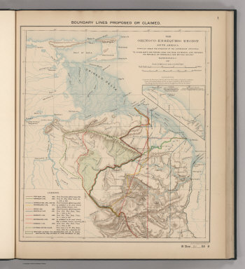
Boundary Lines Proposed or Claimed. 1. S Doc 91 55 2. The Orinoco - Essequibo Region, South America Compiled under the Direction of the Commission Appointed "To Investigate and Report upon the True Divisional Line between the Republic of Venezuela and British Guiana." 1897. Lith. by A. Hoen & Co., Baltimore, MD.
Publisher
United States of America
Author
Venezuela-British Guiana Boundary Commission
Full Title
Forests and Savannas. 2. S Doc 91 55 2. The Orinoco - Essequibo Region, South America, Compiled under the Direction of the Commission Appointed "To Investigate and Report upon the True Divisional Line between the Republic of Venezuela and British Guiana." Washington D.C. 1897. Lith. by A. Hoen & Co., Baltimore, MD.
Publisher
United States of America
Author
Carey, Mathew
Full Title
A New Map of the Caracas. Warnicke Sc.
Publisher
M. Carey and Son
Author
Pinkerton, John, 1758-1826
Full Title
The Caracas. Drawn under the direction of Mr. Pinkerton by L. Hebert. Neele sculpt. 352 Strand. London: published 19th. October 1810 by Cadell & Davies, Strand & Longman, Hurst, Rees, Orme, & Brown, Paternoster Row.
Publisher
[Cadell and Davies, Longman, Hurst, Rees, Orme, and Brown]
|