Browse All

1885 Shields, Clemmer residences. County Atlas Residence of John T. Shields, River-Head … |

1885 Sieg, Brown residences. County Atlas Residence of Henry B. Sieg, Pastures Dis … |

1885 Virginia, W. Virginia. County Atlas Virginia and West Virginia. Rand, McNall … |

1885 Augusta Co., Va. County Atlas Map of Augusta County, Virginia. By Jed. … |

1885 Hoy, Pratt residences. County Atlas Residence of T.F. Hoy, Middle River Dist … |

1885 Kindig, Hamilton, Ott residences; Patter … County Atlas Residence of A.H. Kindig, South River Di … |

1885 Middle River Magist. Dist. County Atlas Map of Middle River Magisterial District … |

1885 Dunlap, Brown farms. County Atlas Farm property of R.B. Dunlap, North Rive … |

1885 N. River Magist. Dist. County Atlas Map of North River Magisterial Dist., Au … |

1885 Waynesboro, N. Waynesboro, Waynesboro Ju … County Atlas Maps of the town of Waynesboro, the vill … |

1885 Pastures Magist. Dist. County Atlas Map of The Pastures Magisterial Dist., A … |

1885 Fishersville, Churchville. County Atlas Plan of Fishersville Village, South Rive … |

1885 Coffman, Patterson residences. County Atlas Residence of Isaac Coffman, Middle River … |

1885 Staunton. County Atlas Map of the city of Staunton, Augusta Co. … |

1885 Hamilton, Landes, Yates residences, Hors … County Atlas Residence of Jno. E. Hamilton, South Riv … |

1885 Fauber, Randolph, Dudley, Mish residence … County Atlas Residence of Geo. W. Fauber, River-Heads … |

1885 Cover: Hist. atlas Augusta Co., Virginia … County Atlas (Covers to) Historical atlas of Augusta … |

1885 Title Page: Hist. atlas Augusta Co., Vir … County Atlas (Title Page to) Historical atlas of Augu … |

1885 Contents: Hist. atlas Augusta Co., Virgi … County Atlas (Contents to) Historical atlas of August … |

1927 Del., Md., Va., W. Va. National Atlas Rand McNally junior auto road map Delawa … |

1927 Philadelphia, Pittsburgh, Richmond, Balt … National Atlas Philadelphia and vicinity. Pittsburgh an … |

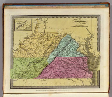
1848 Virginia. World Atlas Virginia. (with) The Western Part of Vir … |

1822 Virginia. World Atlas Virginia. Drawn & Published by F. Lucas … |

1807 Carte des Provines Meridionales des Etat … Historical Atlas Carte des Provinces Meridionales des Eta … |

1807 l'Armee du Sud, in la Virginie, dans les … Historical Atlas Theatre des Operations les plus importan … |

1807 Investissement et Attaque D'York dans la … Historical Atlas Investissement et Attaque D'York dans la … |

1807 Mont-Vernon, habitation du General Washi … Historical Atlas Mont-Vernon, habitation du General Washi … |

1807 Virginia, North Carolina, South Carolina … Historical Atlas A Map of those parts of Virginia, North … |

1807 Investment and Attack of York in Virgini … Historical Atlas Plan of the Investment and Attack of Yor … |

1807 Siege of Charleston in S. Carolina. Historical Atlas Plan of the Siege of Charleston in S. Ca … |

1857 Virginia. National Atlas Virginia. No. 25. Published by J.H. Colt … |

1795 Virginia. Gazetteer Book Virginia. |

1885 Beverly Manor Magist. Dist. County Atlas Map of Beverly Manor Magisterial Distric … |

1885 Hawpe, Seawright residences. County Atlas Residence of J.S. Hawpe, River-Heads Dis … |

1885 Ramsey, Williams residences. County Atlas Residence of D.C. Ramsey, River-Heads Di … |

1885 McChesney residence. County Atlas Residence of Adam McChesney, South River … |

1885 Riverheads Magist. Dist. County Atlas Map of Riverheads Magisterial District, … |

1885 S. River Magist. Dist. County Atlas Map of the South River Magisterial Distr … |
1835 Virginia. World Atlas Virginia. (with) The Western Part of Vir … |

1879 Covers: New Map Of The Peninsula Embraci … Pocket Map (Covers to) Map Of The Peninsula, Embrac … |

1879 New Map Of The Peninsula Embracing Delaw … Pocket Map Map Of The Peninsula, Embracing Delaware … |

1879 Composite: New Map Of The Peninsula Embr … Pocket Map (Composite of) Map Of The Peninsula, Emb … |

1862 Covers: Virginia Pocket Map (Covers to) Map Of The State Of Virginia … |

1862 Virginia Pocket Map Map Of The State Of Virginia Containing … |

1858 Covers: Virginia Pocket Map (Covers to) Map Of The State Of Virginia … |

1858 Virginia Pocket Map Map Of The State Of Virginia Containing … |

1826 Map of Virginia and Maryland. National Atlas Map Of Virginia And Maryland Contrusted … |

1934 Index: Virginia. Railway Distance Maps Guide Book (Index to) Leahy's Hotel Guide and Railw … |

1934 Railway Distance Map of the State of Vir … Guide Book Leahy's Hotel Guide and Railway Distance … |

1838 Virginia. National Atlas Virginia. Entered ... 1838, by T.G. Brad … |