Who What Where WhenREMOVEWHERE
|
Author
[Bayer, Herbert, Container Corporation of America]
Full Title
Conservation of Resources.
Publisher
Container Corporation of America
Author
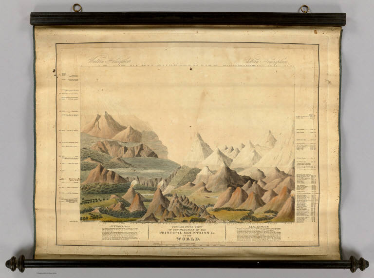
Smith, Charles, fl. 1800-1822
Full Title
Comparative View Of The Heights Of The Principal Mountains &c. In The World. Western Hemisphere. Eastern Hemisphere. London, Published by C. Smith, Mapseller No. 172 Strand, Augt. 1st 1816. Gardner Sculpt.
Publisher
C. Smith
Author
Radefeld, Carl Christian Franz, 1788-1874
Full Title
Welt-Karte in Mercators Projektion. Nach den bessten Quellen entworf. und gezeichn. vom Hauptm. Radefeld. 1844. Verlag des Bibliograph. Instituts zu Hildburghausen, Amsterdam, Paris u. Philadelphia, (1860)
Publisher
Bibliographischen Instituts
Author
Radefeld, Carl Christian Franz, 1788-1874
Full Title
Erd-Karte in der Globular-Projektion. Zu J. Meyer's-Handatlas gehoerend No. 1. Entworfen u. gezeichnet vom Hauptm. Radefeld. Stahlstich, Direction v. Kleinknecht, aus der Schweinfurter Geograph. Graviranstalt des Bibliographisches Instituts zu Hildburghausen, Amsterdam, Paris u. Philadelphia, (1860)
Publisher
Bibliographischen Instituts
Author
Woodbridge, William C.
Full Title
(Covers to) Modern Atlas, Physical, Political And Statistical; Exhibiting On Separate Maps, The Physical And Political Characteristics Of Countries, The Prevailing Religions, Forms Of Government And Degrees Of Civilization, The Climates And Productions Of The Earth, And The Comparative Size Of Countries, Towns, Rivers And Mountains; Accompanied By Geographical And Statistical Tables. By William C. Woodbridge ... Entered .. 1843, by W.C. Woodbridge ... Massachusetts. Hartford. Published By Wm. Jas. Hamersley.
Publisher
Wm. Jas. Hamersley
Author
Woodbridge, William C.
Full Title
(Title Page to) Modern Atlas, Physical, Political And Statistical; Exhibiting On Separate Maps, The Physical And Political Characteristics Of Countries, The Prevailing Religions, Forms Of Government And Degrees Of Civilization, The Climates And Productions Of The Earth, And The Comparative Size Of Countries, Towns, Rivers And Mountains; Accompanied By Geographical And Statistical Tables. By William C. Woodbridge ... Entered .. 1843, by W.C. Woodbridge ... Massachusetts. Hartford. Published By Wm. Jas. Hamersley.
Publisher
Wm. Jas. Hamersley
Author
Woodbridge, William C.
Full Title
(Statistical Tables to) Geographical And Statistical Tables. Mountains in order of their height. Rivers in the order of their length. Lakes in order of their size. Principal canals of the World. United States and Canada. Eastern Continent. Entered .. 1843, by W.C. Woodbridge ... Massachusetts. Hartford. Published By Wm. Jas. Hamersley.
Publisher
Wm. Jas. Hamersley
Author
Woodbridge, William C.
Full Title
(Statistical Tables to) Tables Of The Extent And Population Of Countries. Table Of Principal Cities Of The World In Order Of Their Populations. Entered .. 1843, by W.C. Woodbridge ... Massachusetts. Hartford. Published By Wm. Jas. Hamersley.
Publisher
Wm. Jas. Hamersley
Author
Woodbridge, William C.
Full Title
(Statistical Tables to) Table Of The Population Of The United States. Entered .. 1843, by W.C. Woodbridge ... Massachusetts. Hartford. Published By Wm. Jas. Hamersley.
Publisher
Wm. Jas. Hamersley
Author
Woodbridge, William C.
Full Title
Map Of The World. Adapted To Woodbridge's Geography. Exhibiting The Eastern & Western Hemisphere, And the Land Hemisphere, Together With Comparative View Of the Rivers And Lake of the Two Continents. Includes 2 insets and Comparative View of Rivers & Lakes on The Eastern and Western Continents. Entered ... 1845, by W.C. Woodbridge ... Massachusetts. Hartford. Published By Wm. Jas. Hamersley.
Publisher
Wm. Jas. Hamersley
Author
Woodbridge, William C.
Full Title
Moral And Political Chart Of The Inhabited World. Exhibiting The Prevailing Religion, Form Of Government, Degree Of Civilization, and Population of Each Country. By W.C. Woodbridge. (Engraved by) C. Pelton & W. Williams. Entered .. . 1845, by W.C. Woodbridge ... Massachusetts. Hartford. Published By Wm. Jas. Hamersley. (inset map) Central Europe. (inset map) Untitled map of Polynesia.
Publisher
Wm. Jas. Hamersley
Author
Woodbridge, William C.
Full Title
Isothermal Chart Or View Of Climates: Showing also The Situations Of The Principal Plants & Animals Of The World. By W.C. Woodbridge. Entered .. . 1843, by W.C. Woodbridge ... Massachusetts. Hartford. Published By Wm. Jas. Hamersley. (inset map) Animals of New Holland.
Publisher
Wm. Jas. Hamersley
Author
Woodbridge, William C.
Full Title
Comparative Chart of the Extent of Countries
Publisher
Wm. Jas. Hamersley
Author
[Carey, Mathew, Warner, Benjamin]
Full Title
(Covers to) A General Atlas, Being A Collection Of Maps Of The World And Quarters, Their Principal Empires, Kingdoms, &c. Containing Fifty Eight Maps And Charts. Philadelphia: Published By M. Carey, And B. Warner. 1816.
Publisher
M. Carey and B. Warner
Author
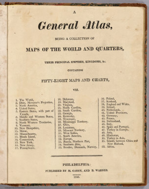
[Carey, Mathew, Warner, Benjamin]
Full Title
(Title Page to) A General Atlas, Being A Collection Of Maps Of The World And Quarters, Their Principal Empires, Kingdoms, &c. Containing Fifty Eight Maps And Charts. Philadelphia: Published By M. Carey, And B. Warner. 1816.
Publisher
M. Carey and B. Warner
Author
[Carey, Mathew, Warner, Benjamin]
Full Title
The World. From Arrowsmith's Map of the World. W. Ralph. sculp. Philada. Published By M. Carey, And B. Warner. 1816.
Publisher
M. Carey and B. Warner
Author
[Carey, Mathew, Warner, Benjamin]
Full Title
Chart Of The World On Mercators Projection. Philadelphia: Published By M. Carey, And B. Warner. 1816.
Publisher
M. Carey and B. Warner
Author
[Sonnenschein, W. Swan, Allen, Bevan, G.P.]
Full Title
(Text Page) The World.
Publisher
Sonnenschein & Allen
Author
[Sonnenschein, W. Swan, Allen, Bevan, G.P.]
Full Title
Chart of the World on Mercator's Projection. W. Swan Sonnenschein & Allen's Plastic School Atlas. (insets) Heligoland, Gibraltar, Malta, Cyprus, Gulf of Aden, and Hong Kong.
Publisher
Sonnenschein & Allen
Author
[Sonnenschein, W. Swan, Allen, Bevan, G.P.]
Full Title
(Text Page) Europe. Physical.
Publisher
Sonnenschein & Allen
Author
[Sonnenschein, W. Swan, Allen, Bevan, G.P.]
Full Title
(Text Page) Europe. Political.
Publisher
Sonnenschein & Allen
Author
Arbuckle Bros.
Full Title
(Cover to) Arbuckles' Illustrated Atlas of Fifty Principal Nations of The World. Copyright, 1889, by Arbuckle Bros. N.Y.
Publisher
Arbuckle Bros.
Author
Arbuckle Bros.
Full Title
(World Map labeled Arbuckles' Ariosa Coffee).
Publisher
Arbuckle Bros.
Author
Colton, G.W.
Full Title
Principal rivers and lakes in the World. (Published by J.H. Colton & Co. 1856)
Publisher
J.H. Colton
Author
[Bayer, Herbert, Container Corporation of America]
Full Title
(Covers to) World Geo-graphic Atlas, A Composite of Man's Environment. Geography, Geology, Demography, Astronomy, Climatology, Economics. Privately printed for Container Corporation of America, 1953, edited and designed by herbert bayer.
Publisher
Container Corporation of America
Author
[Bayer, Herbert, Container Corporation of America]
Full Title
(Text Page) Addenda and Corrigenda at time of printing.
Publisher
Container Corporation of America
Author
[Bayer, Herbert, Container Corporation of America]
Full Title
(Half Title Page) World Geo-graphic Atlas.
Publisher
Container Corporation of America
Author
[Bayer, Herbert, Container Corporation of America]
Full Title
(Title Page) World Geo-graphic Atlas, A Composite of Man's Environment. Geography, Geology, Demography, Astronomy, Climatology, Economics. Privately printed for Container Corporation of America, 1953, edited and designed by herbert bayer.
Publisher
Container Corporation of America
Author
[Paepcke, Walter P., Bayer, Herbert, Container Corporation of America]
Full Title
(Text Page) Preface. Foreward.
Publisher
Container Corporation of America
Author
[Bayer, Herbert, Container Corporation of America]
Full Title
(Table of Contents to) World Geo-graphic Atlas, A Composite of Man's Environment. Geography, Geology, Demography, Astronomy, Climatology, Economics. Privately printed for Container Corporation of America, 1953, edited and designed by herbert bayer.
Publisher
Container Corporation of America
Author
[Bayer, Herbert, Container Corporation of America]
Full Title
(Text Page) Astronomy. The Moon. Our Planet.
Publisher
Container Corporation of America
Author
[Bayer, Herbert, Container Corporation of America]
Full Title
(Text Page) Geology.
Publisher
Container Corporation of America
Author
[Bayer, Herbert, Container Corporation of America]
Full Title
World. Physical.
Publisher
Container Corporation of America
Author
[Bayer, Herbert, Container Corporation of America]
Full Title
World. Climatic Regions.
Publisher
Container Corporation of America
Author
[Bayer, Herbert, Container Corporation of America]
Full Title
World. Pressure and Predominant Winds. World. Temperature.
Publisher
Container Corporation of America
Author
[Bayer, Herbert, Container Corporation of America]
Full Title
World. Annual Rainfall and Ocean Currents.
Publisher
Container Corporation of America
Author
[Bayer, Herbert, Container Corporation of America]
Full Title
World. Natural Vegetation.
Publisher
Container Corporation of America
Author
[Bayer, Herbert, Container Corporation of America]
Full Title
World. Great Soil Groups.
Publisher
Container Corporation of America
Author
Thompson, G.
Full Title
A New Map of the World, with all the New Discoveries by Capt. Cook & other Navigators. Including the Trade Winds, Monsoons and Variation of the Compass, Illustrated with a Coelestial Planisphere, the Various Systems of Ptolomy, Copernicus & Tycho Bray. Together with the Appearance of the Planets, etc. London. Publish'd Jany. 1st. 1798 by G. Thompson No. 43 Long Lane W. Smithfield.
Publisher
G. Thompson
Author
[Phelps, Humphrey, Ensign & Thayer]
Full Title
World At One View. Entered ... 1847, by H. Phelps ... New York. Published by Ensign & Thayer, 36 Ann Street, New York. (inset views) Panoramic View of the Route to China, by the Oregon Railroad and the Pacific Ocean. This Road once Built, Would Become the Great Highway of Nations ; (Mountains of the) Eastern Hemisphere ; Female costumes of the Different Parts of the World ; (Mountains of the) Western Hemisphere ; Waterspout. (inset illustrations of) Caucasian ; Mongul ; African ; Malay.
Publisher
Ensign & Thayer
Author
Collins, P. McD.
Full Title
P. McD. Collins' Proposed Overland Telegraph via Behrings Strait and Asiatic Russia to Europe, Under Russian & British Grants. Furnished by J.H. Colton, 172 William Street, New York. 1864. Entered ... 1855 by J.H. Colton & Co. ... New York.
Publisher
J.H. Colton
Author
[Burr, David H, Haven, J.]
Full Title
The World, on Mercator's Projection: By David H. Burr. Showing the different Routes to California, and distance by each; Routes of different Navigators, Route of the contemplated Pacific R.Road, Distances to China, Europe, &c. Published by J. Haven, 86 State St. Boston; 1850. Entered ... 1850 by John Hansen ... Massachusetts. (with) two inset maps: Map of the Nicaragaua Route and A Map of the Proposed Rail Road from St. Louis To The Bay Of St. Francisco, Compiled from the Maps and Reports of Col. Fremont, by W.L. Dearborn, Civil Engineer.
Publisher
J. Haven
Author
Moore, James B.
Full Title
Chart Prepared By James B. Moore, To Accompany His Memorial To Congress Respecting the subject of Steam Communication with China, Japan &c. 1850. Engr. on Stone by H. Gollmer, Cin. (inset map) Harbour of San Francisco California.
Publisher
H. Gollmer
Author
Manufacturers Life Insurance Company
Full Title
(Map of the World) by The Manufacturers Life Insurance Co., Toronto, Canada. 1909. Hon. G. W. Ross, President ; G. A. Somerville, General Manager.
Publisher
Manufacturers Life Insurance Company
Author
United States Shipping Board
Full Title
United States Shipping Board Services to Principal Ports of World. Port Eyegraph, copyright 1922, Nath. W. Hill, Chatham, N.J. Issues by the Advertising Department of U.S. Shipping Board Emergency Fleet corporation, Washington D.C., January, 1923. Printed in U.S.A.
Publisher
U.S. Shipping Board Emergency Fleet Corporation
Author
[Reid, John M., McCabe, Chas. C.]
Full Title
Domestic And Foreign Missions Of The Methodist Episcopal Church. (These Maps are taken from "History of Missions, Methodist Episcopal Church," by Dr. John M. Reid.) ... (text on verso) One Million For Missions ... John M. Reid. Chas. C. McCabe. New York, March 2, 1885.
Publisher
Phillips & Hunt
Author
[Reid, John M., McCabe, Chas. C.]
Full Title
(Text to) One Million For Missions ... John M. Reid. Chas. C. McCabe. New York, March 2, 1885. (on verso) Domestic And Foreign Missions Of The Methodist Episcopal Church. (These Maps are taken from "History of Missions, Methodist Episcopal Church," by Dr. John M. Reid.) ...
Publisher
Phillips & Hunt
Author
San Francisco Newspaper Maps
Full Title
Map of Iraq; Map of the Suez Canal; Map of Europe; Map of Australia; Map of Malta; (on reverse) Map of the Western Mediterranean; Map of Turkey.
Publisher
San Francisco Examiner and other Newspapers
Author
San Francisco Newspaper Maps
Full Title
Map of the Western Mediterranean; Map of Turkey. (on verso) Map of Iraq; Map of the Suez Canal; Map of Europe; Map of Australia; Map of Malta.
Publisher
San Francisco Examiner and other Newspapers
Author
[Beers, J.B. & Co., H.W. Burgett and Company]
Full Title
Map of the world on Mercator's projection, entered according to act of Congress in the year 1874 by J.B. Beers & Co., in the office of the Librarian of Congress at Washington, DC. (Published by H.W. Burgett & Co. 36 Vesey Street, New-York. 1876. Entered ... 1876 by H.W. Burgett & Co. ... Washington D.C. Engraved & printed by J.B. Beers & Co. 36 Vesey St. N.Y.)
Publisher
H.W. Burgett & Co.
|