Who What Where WhenREMOVEWHATShow MoreWHEREShow More |
Author
[Caylus, Anne Claude Philippe, comte de, 1692-1765, Jefferys, Thomas]
Full Title
Plan of the town and fort of Grenada, by Mr. de Caylus, Engineer General of the French Islands. (with) The Isle of Grenada. T. Jefferys, sculp. (1760)
Publisher
Thomas Jefferys
Author
Jefferys, Thomas
Full Title
The island and colony of Cayenne subject to the French on the continent of South America. By Thomas Jefferys, Geographer to His Royal Highness the Prince of Wales. T. Jefferys sculp.
Publisher
Thomas Jefferys
Author
[Jefferys, Thomas, Marchais, R. de]
Full Title
Plan of the town of Cayenne and Fort St. Michael. Drawn by the Chevalier de Mareechais. T. Jefferys sculp. (1760)
Publisher
Thomas Jefferys
Author
Jefferys, Thomas
Full Title
(Covers to) The natural and civil history of the French dominions in North and South America. Giving a particular account of the climate, soil, minerals, animals, vegetables, manufactures, trade, commerce, and languages ... Illustrated by maps and plans of the principal places, collected from the best authorities, and engraved by T. Jefferys, Geographer to his Royal Highness the Prince of Wales. Part I. Containing a description of Canada and Louisiana. London, Printed for Thomas Jefferys at Charing-Cross. MDCCLX.
Publisher
Thomas Jefferys
Author
Jefferys, Thomas
Full Title
Thomas Jefferys Engraver Geographer to His Royal Highness the Prince of Wales, at y Corner of St. Martins Lane near Charing Cross Sells great Variety of Prints English and Foreign by the most Celebrated Masters And all Sorts of Maps and Globes. Ant: Walker. Inv: del: et Sculpt. (trade card advertisement).
Publisher
No Publisher
Author
Jefferys, Thomas
Full Title
(Text page to) The West-India atlas: or, a compendious description of the West-Indies: illustrated with forty one correct charts and maps, taken From actual surveys. Together with an historical account of the several countries and islands which compose that part of the world. By the late Thomas Jefferys, Geographer to the King. London: Printed for Robert Sayer and John Bennett, Map, Chart, Print-Sellers, and Globe Makers, Fleet-Street, M,DCC,LXXXIII. Introduction.
Publisher
Sayer and Bennett
Author
Jefferys, Thomas
Full Title
(Text page to) The West-India atlas: or, a compendious description of the West-Indies: illustrated with forty one correct charts and maps, taken From actual surveys. Together with an historical account of the several countries and islands which compose that part of the world. By the late Thomas Jefferys, Geographer to the King. London: Printed for Robert Sayer and John Bennett, Map, Chart, Print-Sellers, and Globe Makers, Fleet-Street, M,DCC,LXXXIII.
Publisher
Sayer and Bennett
Author
Jefferys, Thomas
Full Title
(Text page to) The West-India atlas: or, a compendious description of the West-Indies: illustrated with forty one correct charts and maps, taken From actual surveys. Together with an historical account of the several countries and islands which compose that part of the world. By the late Thomas Jefferys, Geographer to the King. London: Printed for Robert Sayer and John Bennett, Map, Chart, Print-Sellers, and Globe Makers, Fleet-Street, M,DCC,LXXXIII. (Right-hand page): "The West-India Atlas, Part I. A General View of the West Indies."
Publisher
Sayer and Bennett
Author
Jefferys, Thomas
Full Title
(Text page to) The West-India atlas: or, a compendious description of the West-Indies: illustrated with forty one correct charts and maps, taken From actual surveys. Together with an historical account of the several countries and islands which compose that part of the world. By the late Thomas Jefferys, Geographer to the King. London: Printed for Robert Sayer and John Bennett, Map, Chart, Print-Sellers, and Globe Makers, Fleet-Street, M,DCC,LXXXIII.
Publisher
Sayer and Bennett
Author
Jefferys, Thomas
Full Title
(Text page to) The West-India atlas: or, a compendious description of the West-Indies: illustrated with forty one correct charts and maps, taken From actual surveys. Together with an historical account of the several countries and islands which compose that part of the world. By the late Thomas Jefferys, Geographer to the King. London: Printed for Robert Sayer and John Bennett, Map, Chart, Print-Sellers, and Globe Makers, Fleet-Street, M,DCC,LXXXIII.
Publisher
Sayer and Bennett
Author
Pownall, Thomas
Full Title
The Atlantic Ocean by Governor Pownall, F.R.S. Published 20th Septr. 1787, by Robt. Sayer, 53 Fleet Street, London.
Publisher
Sayer and Bennett
Author
Ravell, Anthony
Full Title
St. Christophers, or St. Kitts, surveyed by Anthony Ravell Esqr., Surveyor General of the islands of St. Christopher, Nevis & Montserrat. Engraved by Thomas Jefferys, Geographer to the King. London, printed for Robt. Sayer, Map & Printseller, no. 53 in Fleet Street, as the Act directs 20th Feby. 1775.
Publisher
Sayer and Bennett
Author
[Jefferys, Thomas, Robert Laurie & James Whittle]
Full Title
A new map of the island and kingdom of Corsica by Thomas Jefferys, Geographer to the King, with additions and improvements. London, Published by Laurie & Whittle, 53, Fleet Street, as the act directs 12th May, 1794
Publisher
Laurie & Whittle
Author
[Jefferys, Thomas, Robert Laurie & James Whittle]
Full Title
The German dominions of the King of Great Britain; comprized under the name of Electorate of Brunswick-Luneburg and including the dutchies of Bremen, Verden, Luneburg-Zell, Calenberg and Grubenhagen. With the counties of Danneberg, Diepholt and Hoya, to which are added the dominions of Brunswick-Wolfenbuttel. By Thomas Jefferys, Geographer to His Majesty. London, Published by Laurie & Whittle, 53, Fleet Street, as the act directs 12th May, 1794.
Publisher
Laurie & Whittle
Author
[Jefferys, Thomas, Robert Laurie & James Whittle]
Full Title
The Kingdom of Bohemia with the Dutchy of Silesia and the marquisates of Moravia and Lusatia. By Thomas Jefferys, Geographer to the King. London, Published by Laurie & Whittle, 53, Fleet Street, 12th May, 1794.
Publisher
Laurie & Whittle
Author
[Anville, Jean Baptiste Bourguignon d, 1697-1782, Jefferys, Thomas, Sayer, Robert]
Full Title
The western coast of Africa from Cape Blanco to Cape Virga, exhibiting Senegambia Proper. By T. Jefferys, Geographer to his Majesty. London, Printed by Robt. Sayer, No. 53, Fleet Street, 1789.
Publisher
Laurie & Whittle
Author
[Jefferys, Thomas, Robert Laurie & James Whittle]
Full Title
Jamaica from the latest surveys; improved and engraved by Thomas Jefferys, Geographer to the King. (with) The harbour of Bluefields. (with) The harbours of Kingston and Port Royal. Published by Laurie & Whittle, No. 53, Fleet Street, as the act directs 12th May, 1794.
Publisher
Laurie & Whittle
Author
[Faden, William, 1750?-1836, Jefferys, Thomas]
Full Title
Europe. Engraved by Jefferys and Faden, Geographers to the King. London, publish'd according to Act of Parliament, 29th May, 1775, by Jefferys & Faden, Corner of St. Martin's Lane, Charing Cross.
Publisher
William Faden
Author
[Faden, William, 1750?-1836, Jefferys, Thomas]
Full Title
Europe. London, published by Jefferys and Faden, Corner of St. Martin's Lane, Charing Cross. (1775?)
Publisher
William Faden
Author
[Faden, William, 1750?-1836, Jefferys, Thomas]
Full Title
Asia. Engraved by Jefferys & Faden, Geographers to the King. London, published as the Act directs, 29th May, 1775, by Jefferys & Faden, St. Martin's Lane, Charing Cross.
Publisher
William Faden
Author
[Faden, William, 1750?-1836, Jefferys, Thomas]
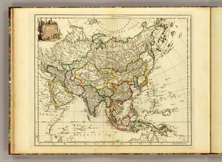
Full Title
Asia. London, publish'd by Jefferys & Faden, Corner of St. Martin's Lane, Charing Cross. (1775?)
Publisher
William Faden
Author
[Faden, William, 1750?-1836, Jefferys, Thomas]
Full Title
Africa. Engraved by Faden and Jefferys, Geographer to the King. London: publish'd according to Act of Parliament, 29th May, 1775 by Faden & Jefferys, Corner of St. Martin's Lane, Charing Cross.
Publisher
William Faden
Author
[Faden, William, 1750?-1836, Jefferys, Thomas]
Full Title
Africa. London, publish'd by Jefferys and Faden, Corner of St. Martin's Lane, Charing Cross. (1775?)
Publisher
William Faden
Author
[Faden, William, 1750?-1836, Jefferys, Thomas]
Full Title
Eastern Hemisphere. Engraved by Faden and Jefferys, Geographer to the King. London, publish'd according to Act of Parliament, 17 Novr. 1773, by Jefferys & Faden, ye Corner of St. Martin's Lane.
Publisher
William Faden
Author
[Faden, William, 1750?-1836, Jefferys, Thomas]
Full Title
Eastern Hemisphere. London, published by Jefferys & Faden, Corner of St. Martin's Lane, Charing Cross. (1773?)
Publisher
William Faden
Author
[Faden, William, 1750?-1836, Jefferys, Thomas]
Full Title
Western Hemisphere. Engraved by Faden and Jefferys, Geographer to the King. London, publish'd according to Act of Parliament, 28th February 1775 by Jefferys and Faden, the Corner of St. Martin's Lane.
Publisher
William Faden
Author
[Faden, William, 1750?-1836, Jefferys, Thomas]
Full Title
Western Hemisphere. London, publish'd by Jefferys & Faden, Corner of St. Martin's Lane, Charing Cross. (1775?)
Publisher
William Faden
Author
[Faden, William, 1750?-1836, Jefferys, Thomas]
Full Title
Northern Hemisphere. Engraved by Faden and Jefferys, Geographer to the King. London: publish'd according to Act of Parliament, 29th May, 1775, by Jefferys & Faden, the Corner of St. Martin's Lane, Charing Cross.
Publisher
William Faden
Author
[Faden, William, 1750?-1836, Jefferys, Thomas]
Full Title
(Nor)thern Hemisphere. London, publish'd by Jefferys & Faden, Corner of St. Martin's Lane, Charing Cross. (1775?)
Publisher
William Faden
Author
[Faden, William, 1750?-1836, Jefferys, Thomas]
Full Title
Southern Hemisphere. Engraved by Faden & Jefferys, Geographer to the King. London, publish'd according to Act of Parliament, 29th May 1775, by Jefferys & Faden, the Corner of St. Martin's Lane, Charing Cross.
Publisher
William Faden
Author
[Faden, William, 1750?-1836, Jefferys, Thomas]
Full Title
(Sou)thern Hemisphere. London, publish'd by Jefferys & Faden, Corner of St. Martin's Lane, Charing Cross. (1775?)
Publisher
William Faden
Author
[Faden, William, 1750?-1836, Jefferys, Thomas]
Full Title
A chart of the World upon Mercator's projection. Describing the tracks of Capt. Cook in the year 1768, 69, 70, 71, and in 1772, 73, 74, 75, with the new discoveries. London, publish'd according to Act of Parliament by Jefferys & Faden, Corner of St. Martin's Lane, Charing Cross. 1775.
Publisher
William Faden
Author
[Faden, William, 1750?-1836, Jefferys, Thomas]
Full Title
A chart of the World upon Mercator's projection. London, published by Jefferys & Faden, Corner of St. Martin's Lane, Charing Cross. (1775?).
Publisher
William Faden
Author
Jefferys, Thomas
Full Title
From map of North America by Thomas Jefferys. 1782. Reduced. Julius Bien, Photo-lith. U.S. Geographical Surveys West of the 100th Meridian. (1889)
Publisher
U.S.
Author
[Faden, William, 1750?-1836, Jefferys, Thomas]
Full Title
A new map of the King of Great Britain's dominions in Germany, or the Electorate of Brunswick-Luneburg and its dependencies. By Thomas Jefferys, Geographer to his Majesty with various improvements and emendations. London, published by W. Faden, Geographer to the King, Charing Cross, June 1st, 1789.
Publisher
William Faden
Author
Jefferys, Thomas
Full Title
(Facsimile) Jefferys - 1775. 41. S Doc 9a 55 2. Part of a Chart of the Coast of Guiana by Thomas Jefferys, London, 1775. Reproduced from Original (in his West-India Atlas, London, 1788, Pl. A1. 17,) in Library of Congress, Washington, D.C.. Photo.Lith. by A. Hoen & Co., Baltimore, MD.
Publisher
United States of America
Author
Jefferys, Thomas
Full Title
(Facsimile) Jefferys - 1781. 42. S Doc 9a 55 2. Part of a Chart of the Coast of Guiana by Thomas Jefferys, London, 1781. Reproduced from Original (in his West-India Atlas, London, 1783, Pl. XVII,) in Library of Congress, Washington, D.C.. Photo.Lith. by A. Hoen & Co., Baltimore, MD.
Publisher
United States of America
Author
Jefferys, Thomas
Full Title
(Facsimile) Jefferys - 1792. 44. S Doc 9a 55 2. Novr. 1st. 1792. Part of a Chart of the Northern Coast of South America by Thomas Jefferys, 1792. Reproduced from Original (in his West-India Atlas, London, 1794, Pl. A I. 17,) in Library of Congress, Washington, D.C. Photo.Lith. by A. Hoen & Co., Baltimore, MD.
Publisher
United States of America
Author
Jefferys, Thomas
Full Title
(Facsimile) Jefferys - 1795. 45. S Doc 9a 55 2. Part of a Chart of the Coast of Guiana by Thomas Jefferys, 1795. Reproduced from Original (in his West-India Atlas, London, 1818, No. 33,) in Library of Congress, Washington, D.C. Photo.Lith. by A. Hoen & Co., Baltimore, MD.
Publisher
United States of America
Author
Jefferys, Thomas
Full Title
(The East Indies, with the roads. Northern section. By Thomas Jefferys, Geographer to the King. MDCCLXVIII. The second edition. London, published according to Act of Parliament, 30th Apr. 1768 by Robt. Sayer, no. 53 in Fleet Street)
Publisher
Robert Sayer
Author
Jefferys, Thomas
Full Title
The East Indies, with the roads. (Southern section). By Thomas Jefferys, Geographer to the King. MDCCLXVIII. The second edition. London, published according to Act of Parliament, 30th Apr. 1768 by Robt. Sayer, no. 53 in Fleet Street.
Publisher
Robert Sayer
|