Who What Where WhenREMOVEWHEN |
REFINE
Browse All : Images of Mediterranean and Turkey and Israel from 1815
1-32 of 32
Author
La Perouse, Jean-Francois de Galaup, comte de, 1741-1788
Full Title
Terebartulae, or Anomle of Linnaeus. Cornu Ammonis from the Pacifc Ocean between the tropics.. Published as the Act directs Novr. 1st 1798, by G.G. & J. Robinson, Pater Noster Row, London. Prevost delt. No. 63.
Publisher
G.G. & J. Robinson.
Author
La Perouse, Jean-Francois de Galaup, comte de, 1741-1788
Full Title
Chart of the Archipelago of Navigators (Samoa), Discovered by Mr. de Bougainville in May 1768, and Explored by the Boussole & the Astrolabe in December 1787. Published as the Act directs Novr. 1st 1798, by G.G. & J. Robinson, Paternoster Row. Neele Sculpt., Strand. No. 64.
Publisher
G.G. & J. Robinson.
Author
La Perouse, Jean-Francois de Galaup, comte de, 1741-1788
Full Title
(Two charts on one sheet). Plan of a Part of the Island of Maouna (Pago Pago, Samoa), Visited by the Boussole & the Astrolabe in December 1787. Plan of Massacre Cove on the North West Side of Amouna, one of the Navigators Islands. Published as the Act directs Novr. 1st 1798, by G.G. & J. Robinson, Paternoster Row. S. Neele Sculpt., Strand. No. 65.
Publisher
G.G. & J. Robinson.
Author
La Perouse, Jean-Francois de Galaup, comte de, 1741-1788
Full Title
(Two maps and one view). Plan of Easter Island, taken in April 1786, on Board the Boussole & the Astrolabe. Views of Easter Island on a Scale of two Inches to a League. Plan of Cook's Bay on the West Side of Easter Island .... Published as the Act directs Novr. 1st 1798, by G.G. & J. Robinson, Pater-noster Row. Heath Sculpt. No. 10.
Publisher
G.G. & J. Robinson.
Author
La Perouse, Jean-Francois de Galaup, comte de, 1741-1788
Full Title
Chart of the Coasts of America & Asia from California to Macao according to the Discoveries made in 1786 & 1787 by the Boussole & Astrolabe. Published as the Act directs Novr. 1st 1798, by G.G. & J. Robinson, Paternoster Row. S. Neele, sculpt, Strand. No. 15.
Publisher
G.G. & J. Robinson.
Author
La Perouse, Jean-Francois de Galaup, comte de, 1741-1788
Full Title
Chart of Part of the North West Coast of America Explored by the Boussole & Astrolabe laid down conformally to the position of the Boussole every day at noon as determinined Astronomically by Mr. Dagelet. Published as the Act directs Novr. 1st 1798, by G.G. & J. Robinson, Paternoster Row. S. Neele, sculpt, Strand. No. 16.
Publisher
G.G. & J. Robinson.
Author
La Perouse, Jean-Francois de Galaup, comte de, 1741-1788
Full Title
Chart of Part of the Northwest Coast of America. Explored by the Boussole & Astrolabe lin 1787. Ist Sheet. Published as the Act directs Novr. 1st 1798, by G.G. & J. Robinson, Paternoster Row. No. 17.
Publisher
G.G. & J. Robinson.
Author
La Perouse, Jean-Francois de Galaup, comte de, 1741-1788
Full Title
Plan of the Port des Francais on the North West Coast of America in 58 degrees 37 minutes Latitude North and 139 degrees 50 minutes of Longitude West, Discovered nd. July 1786, by the Boussole & Astrolabe. Published as the Act directs Novr. 1st 1798, by G.G. & J. Robinson, Paternoster Row, London. Neele, sculpt., 352 Strand. No. 19.
Publisher
G.G. & J. Robinson.
Author
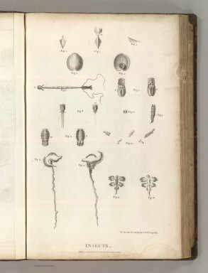
La Perouse, Jean-Francois de Galaup, comte de, 1741-1788
Full Title
Insects. Published as the act directs Novr. 1st 1798, by G.G. & J. Robinson, Pater-noster Row, London.
Publisher
G.G. & J. Robinson.
Author
La Perouse, Jean-Francois de Galaup, comte de, 1741-1788
Full Title
Plan of the Entrance of the Port of Bucarelli on the North West Coast of America, in 55 dgrees 15 minutes of Latitidue North & 136 degrees 15 minutes of Longitude West of Paris:* Discovered in 1775 by the Spanish Schooner la Senora Commanded by D. Juan Fco. de la Quadra & D. Franco. Alto. Maurelle; and more amply explored in the Expedition of 1779 .... Published as the Act directs Novr. 1st 1798, by G.G. & J. Robinson, Paternoster Row, London. Neele, sc. Strand. No. 26.
Publisher
G.G. & J. Robinson.
Author
La Perouse, Jean-Francois de Galaup, comte de, 1741-1788
Full Title
Echini Marini, or Sea Urchins, of the North West Coast of America. Published as the (act) directs Novr. 1st 1798, by G.G. & J. Robinson, Pater-noster Row, London. No. 27.
Publisher
G.G. & J. Robinson.
Author
La Perouse, Jean-Francois de Galaup, comte de, 1741-1788
Full Title
Great Sea Urchins, of the North West Coast of America. Published as the Act directs Novr. 1st 1798, by G.G. & J. Robinson, Pater Noster Row, London. Prevost, delt. No. 28.
Publisher
G.G. & J. Robinson.
Author
La Perouse, Jean-Francois de Galaup, comte de, 1741-1788
Full Title
Chart of the North West Coast of America. Explored by the Boussole & Astrolabe in 1786. 2nd. Sheet. Published as the Act directs Novr. 1st 1798, by G.G. & J. Robinson, Paternoster Row, London. Neele sc. Strand. No. 29.
Publisher
G.G. & J. Robinson.
Author
La Perouse, Jean-Francois de Galaup, comte de, 1741-1788
Full Title
Chart of the North West Coast of America. Explored by the Boussole & Astrolabe in 1786. 3d. Sheet. Published as the Act directs Novr. 1st 1798, by G.G. & J. Robinson, Paternoster Row, London. No. 31.
Publisher
G.G. & J. Robinson.
Author
La Perouse, Jean-Francois de Galaup, comte de, 1741-1788
Full Title
Views of the North West Coast of America. Explored by the Boussole & Astrolabe in 1786. 3rd. Sheet. Published as the act directs Novr. 1st 1798, by G.G. & J. Robinson, Pater-noster Row, London. No. 32.
Publisher
G.G. & J. Robinson.
Author
La Perouse, Jean-Francois de Galaup, comte de, 1741-1788
Full Title
Plan of the Port of St. Francisco in California. Point de Reyes in 37 degrees 59 minutes of Latitude North & 124 degrees, 54 minutes Longitude - West. Published as the Act directs Novr. 1st 1798, by G.G. & J. Robinson, Paternoster Row, London. Neele, sculpt., Strand. No. 33.
Publisher
G.G. & J. Robinson.
Author
La Perouse, Jean-Francois de Galaup, comte de, 1741-1788
Full Title
Plan of the Bay of Monterey, Situate in North California, in 36 degrees 38 minutes of Latitude North & 124 degrees, 3 minutes Longitude - West, to Illustrate the Voyage of La Perouse. Published as the Act directs Novr. 1st 1798, by G.G. & J. Robinson, Pater-noster Row, London. S. Neele, sculpt., Strand. No. 34.
Publisher
G.G. & J. Robinson.
Author
La Perouse, Jean-Francois de Galaup, comte de, 1741-1788
Full Title
(Two charts) Plan of the Port of S. Diego in California. Situate in in 32 degrees 39 minutes 0 seconds of Latitude North & 12 degrees, 4 minutes 0 seconds West of St. Blas from a Survey in 1782 .... Plan of the Port and Department of S. Blas, Situate 21 degrees 30 minutes of Latitude Nth. & 88 degrees 15 minutes 0 seconds _ West of Tenefriffe and 107 degrees 15 minutes 0 seconds _ West of Paris from a Survey in november 1877. Published as the Act directs Novr. 1st 1798, by G.G. & J. Robinson, Paternoster Row, London. S. Neele, sculpt., Strand. No. 35.
Publisher
G.G. & J. Robinson.
Author
La Perouse, Jean-Francois de Galaup, comte de, 1741-1788
Full Title
Male & Female Partridge of California. Published as the Act directs Novr. 1st 1798, by G.G. & J. Robinson, Pater Noster Row, London. Prevost, del. Heath, sculp., Strand. No. 36.
Publisher
G.G. & J. Robinson.
Author
La Perouse, Jean-Francois de Galaup, comte de, 1741-1788
Full Title
Chart of Necker Island in 23 degrees 34 minutes of Latitude N. & 168 degrees 10 minutes Longitude West of Paris and of the Basse des Fregates Francaises of French Frigate Schoal in 23 degrees 45 minutes of Latitude N. & 168 degrees 10 minutes of Longitude, Discovered in Novermber 1786. Published as the Act directs Novr. 1st 1798, by G.G. & J. Robinson, Paternoster Row, London. Neele, sculpt., Strand. No. 38.
Publisher
G.G. & J. Robinson.
Author
La Perouse, Jean-Francois de Galaup, comte de, 1741-1788
Full Title
Chart of Discoveries made in 1787 In the Seas of China and Tartary between Manilla and Avateha by the Boussole & Astrolabe. Published as the Act directs Novr. 1st 1798, by G.G. & J. Robinson, Paternoster Row, London. Neele, sculpt., Strand. No. 39.
Publisher
G.G. & J. Robinson.
Author
La Perouse, Jean-Francois de Galaup, comte de, 1741-1788
Full Title
View of Macao in China. Published as the Act directs Novr. 1st 1798, by G.G. & J. Robinson, Pater Noster Row, London. de Vancy delt. Heath sculpt. No. 40.
Publisher
G.G. & J. Robinson.
Author
La Perouse, Jean-Francois de Galaup, comte de, 1741-1788
Full Title
Chart of Discoveries, Made in 1787, in the Seas of China and Tartary, by the Boussole and Astrolabe, from their Leaving Manilla, to their Arrival at Kamtschatka, Sheet 1. Published as the Act directs Novr. 1st 1798, by G.G. & J. Robinson, Pater-noster Row, London. Neele sculpt. Strand. No. 43.
Publisher
G.G. & J. Robinson.
Author
La Perouse, Jean-Francois de Galaup, comte de, 1741-1788
Full Title
Plan of the Islands or Archipellago of Corea seen in May 1787 by Boussole and Astrolabe. Published as the Act directs Novr. 1st 1798, by G.G. & J. Robinson, Paternoster Row, London. S. Neele sculpt. Strand. No. 44.
Publisher
G.G. & J. Robinson.
Author
La Perouse, Jean-Francois de Galaup, comte de, 1741-1788
Full Title
(Five maps on one sheet:) Part of the Island of Quelpaert ...; Plan of the Island of Hoapinsu ...; Plan of the Isle Dagelet ...; Part of the Island of Botol...; Plan of the Island of Kumi, seen ... May 1787 by the Boussole and Astrolabe. Published as the Act directs Novr. 1st 1798, by G.G. & J. Robinson, Paternoster Row, London. S. Neele sculpt. Strand. No. 45.
Publisher
G.G. & J. Robinson.
Author
La Perouse, Jean-Francois de Galaup, comte de, 1741-1788
Full Title
Chart of the Discoveries made in 1787, in the Seas of China and Tartary by the Boussole and Astrolabe from their leaving Manilla and Arriving in Kamtschatka, Sheet II. Published as the Act directs Novr. 1st 1798, by G.G. & J. Robinson, Paternoster Row, London. Neele sculpt. Strand. No. 46.
Publisher
G.G. & J. Robinson.
Author
La Perouse, Jean-Francois de Galaup, comte de, 1741-1788
Full Title
Chart of the Discoveries to the North of Japan, in 1643, by the Dutch Ships the Kastrikum & the Breskens, Including the Land of Jeso, Staten Island, & Company's Land, of which Part was Explored in 1787 by the Boussle and Astrolabe. Published as the Act directs Novr. 1st 1798, by G.G. & J. Robinson, Paternoster Row, London. Neele sculpt. Strand. No. 47.
Publisher
G.G. & J. Robinson.
Author
La Perouse, Jean-Francois de Galaup, comte de, 1741-1788
Full Title
Plan of Baie de Ternai Situate on the Coast of Tartary .... This Bay was Discovered the 22nd of June 1787 by the French Frigates la Boussole and l'Astrolabe.... Published as the Act directs Novr. 1st 1798, by G.G. & J. Robinson, Paternoster Row, London. Neele sculpt. Strand. No. 48.
Publisher
G.G. & J. Robinson.
Author
La Perouse, Jean-Francois de Galaup, comte de, 1741-1788
Full Title
Plan of La Baie de Langle on the West Side of the Isle of Tchoka .... Published as the Act directs Novr. 1st 1798, by G.G. & J. Robinson, Paternoster Row, London. S.J.Neele sculpt. Strand. No. 49.
Publisher
G.G. & J. Robinson.
Author
La Perouse, Jean-Francois de Galaup, comte de, 1741-1788
Full Title
Plan of La Baie Destaing on the Eastern Coast of Tchoka .... Published as the Act directs Novr. 1st 1798, by G.G. & J. Robinson, Paternoster Row, London. Neele sculpt. Strand. No. 51.
Publisher
G.G. & J. Robinson.
Author
La Perouse, Jean-Francois de Galaup, comte de, 1741-1788
Full Title
Plan of the Baie de Castries, on the Eastern Coast of Tartary ... by Sen. Bernizet, under the Inspection of Mr. de la Perouse. Published as the Act directs Novr. 1st 1798, by G.G. & J. Robinson, Paternoster Row: London. Engraved by S. Neele sculpt. 352 Strand. No. 52.
Publisher
G.G. & J. Robinson.
Author
La Perouse, Jean-Francois de Galaup, comte de, 1741-1788
Full Title
(Two views). Parao,a Passage Boat of Manilla. Sarambeau, a Fishing Raft of Manilla. Published as the Act directs Novr. 1st 1798, by G.G. & J. Robinson, Pater Noster Row, London. Blondela del. Heath sculpt. No. 58.
Publisher
G.G. & J. Robinson.
1-32 of 32
|