Who What Where WhenREMOVE |
Author
Tanner, Henry S.
Full Title
Italia Antiqua. Published by H.S. Tanner, Philadelphia. (1826)
Publisher
H.S. Tanner
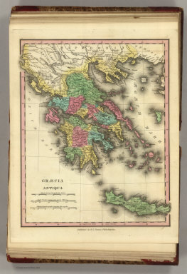
Author
Tanner, Henry S.
Full Title
Graecia Antiqua. Published by H.S. Tanner, Philadelphia. (1826)
Publisher
H.S. Tanner
Author
Tanner, Henry S.
Full Title
Graecia Pars Septentrionalis aliter Macedonia, Thessalia & Epirus cum Traci.. Published by H.S. Tanner, Philadelphia. (1826)
Publisher
H.S. Tanner
Author
Tanner, Henry S.
Full Title
Germania Antiqua. Published by H.S. Tanner, Philadelphia. (1826)
Publisher
H.S. Tanner
Author
Tanner, Henry S.
Full Title
Brittannicae Insule ex Aevi Romani Monumentis. Published by H.S. Tanner, Philadelphia. (1826)
Publisher
H.S. Tanner
Author
Tanner, Henry S.
Full Title
Palestina seu Terra Sancta. Published by H.S. Tanner, Philadelphia. (1826)
Publisher
H.S. Tanner
Author
Tanner, Henry S.
Full Title
Map Of South America. Carefully Compiled from the Latest Maps & Charts And Other Geographical Publications. Philadelphia: Published by Henry S. Tanner 1845. Engraved by J.H. Young & F. Dankworth Philada. (with 4 inset maps).
Publisher
Henry S. Tanner
Author
Tanner, Henry S.
Full Title
(Covers and Title Page to) United States of America: by H.S. Tanner, 1839. Philadelphia, Published by Henry S. Tanner. Entered ... 1838, by H.S. Tanner ... Pennsylvania. Engraved by H.S. Tanner, assisted by E.B. Dawson, W. Allen & J. Knight. (title by) J.W. Steel Sc. (with 17 inset maps and 1 profile). (with index) An alphabetical index to the four sheet map of the United States by H. S. Tanner. Philadelphia: Rackliff and Jones, Printers, South-West Corner of George and Swanwick streets.
Publisher
H.S. Tanner
Author
Tanner, Henry S.
Full Title
United States of America: by H.S. Tanner, 1839. Philadelphia, Published by Henry S. Tanner. Entered ... 1838, by H.S. Tanner ... Pennsylvania. Engraved by H.S. Tanner, assisted by E.B. Dawson, W. Allen & J. Knight. (title) J.W. Steel Sc. (with 17 inset maps and 1 profile). (with index) An Alphabetical Index To The Four Sheet Map Of The United States, By H. S. Tanner. Philadelphia: Rackliff And Jones, Printers, South-West corner of Geogre and Swanwick streets.
Publisher
H.S. Tanner
Author
Lucas, Fielding Jr.
Full Title
Western Hemisphere. H.S. Tanner fe.
Publisher
Fielding Lucas Jr.
Author
Boye, Herman
Full Title
A Map of the State of Virginia Reduced From the Nine Sheet Map of the State, In Conformity to Law: by Herman Boye. Engraved by H.S. Tanner and E.B. Dawson. Entered ... the 31st day of October 1827 by W.B. Giles ... Virginia.
Publisher
H.S. Tanner
Author
Mitchell, Samuel Augustus
Full Title
A new map of New York with its canals, roads & distances from place to place along the stage & steam-boat routes. (with) Profile of the Erie Canal. (Published by S. Augustus Mitchell, Philadelphia. 1846). Entered ... 1840 by H.S. Tanner ... Pennsylvania.
Publisher
S.A. Mitchell
Author
Mitchell, Samuel Augustus
Full Title
City of New-York. (Published by S. Augustus Mitchell, Philadelphia. 1846). Entered ... 1835 by H.S. Tanner ... Pennsylvania.
Publisher
S.A. Mitchell
Author
Mitchell, Samuel Augustus
Full Title
Connecticut. (with) Hartford &c. (with) New Haven &c. Published by S. Augustus Mitchell, N.E. corner of Market & 7th streets, Philada., 1846. Entered ... 1839 by H.S. Tanner ... Pennsylvania.
Publisher
S.A. Mitchell
Author
[Mitchell, Samuel Augustus, Tanner, Henry S.]
Full Title
Massachusetts and Rhode Island: by H.S. Tanner. (with) Boston. Published by S. Augustus Mitchell, N.E. corner of Market & 7th sts., Philada., 1846. Entered ... 1841 by H.S. Tanner ... Pennsylvania.
Publisher
S.A. Mitchell
Author
Mitchell, Samuel Augustus
Full Title
New Hampshire & Vermont: published by S. Augustus Mitchell. N.E. corner of Market & 7th streets, Philada., 1846. Entered ... 1840 by H.S. Tanner ... Pennsylvania.
Publisher
S.A. Mitchell
Author
Mitchell, Samuel Augustus
Full Title
A new map of Maine. Published by S. Augustus Mitchell, N.E. corner of Market & 7th streets, Philada. 1846. Entered ... 1840 by H.S. Tanner ... Pennsylvania.
Publisher
S.A. Mitchell
Author
Mitchell, Samuel Augustus
Full Title
(Covers to) Maps of Maine, New Hampshire and Vermont, Massachusetts & Rhode Island, Connecticut, New York, and New York City. Published by S. Augustus Mitchell, North East corner of Market and Seventh streets, Philadelphia. 1846. Evans, Printer. Fourth below Chestnut.
Publisher
S.A. Mitchell
Author
Melish, John
Full Title
Map of the United States with the contiguous British & Spanish Possessions Compiled from the latest & best Authorities By John Melish. Engraved by J. Vallance & H.S. Tanner. Entered ... 6th day of June 1816. Published by John Melish Philadelphia. (inset) West Indies.
Publisher
John Melish
Author
Melish, John
Full Title
(Composite of) Map of the United States with the contiguous British & Spanish Possessions Compiled from the latest & best Authorities By John Melish. Engraved by J. Vallance & H.S. Tanner. Entered ... 16th day of June 1820. Published by James Finlayson Agent Philada. Successor to John Melish, Improved to 1823. (inset) West Indies.
Publisher
James Finlayson
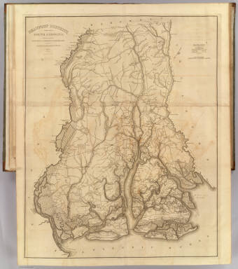
Author
Mills, Robert
Full Title
Charleston District, South Carolina. Surveyed By Charles Vignoles & Henry Ravenel. 1820. Improved for Mills' Atlas, 1825. Engd. by H.S. Tanner & Assistants.
Publisher
Tanner/Lucas
Author
Mills, Robert
Full Title
Abbeville District, South Carolina. Surveyed By Wm. Robertson, 1820. Improved for Mills' Atlas, 1825. Engd. by H.S. Tanner & Assistants.
Publisher
Tanner/Lucas
Author
Mills, Robert
Full Title
Beaufort District, South Carolina. Surveyed By C. Vignoles & H. Ravenel, 1820. Improved for Mills' Atlas, 1825. Engd. by H.S. Tanner & Associates.
Publisher
Tanner/Lucas
Author
Mills, Robert
Full Title
Chesterfield District, South Carolina. Surveyed By John Lowry, 1819. Improved for Mills' Atlas, 1825. Engd. by H.S. Tanner & Assistants.
Publisher
Tanner/Lucas
Author
Mills, Robert
Full Title
Colleton District, South Carolina. Surveyed By Saml. A. Ruddock, 1820. Improved for Mills' Atlas, 1825. Engd. by H.S. Tanner & Assistants.
Publisher
Tanner/Lucas
Author
Mills, Robert
Full Title
Darlington District, South Carolina. Improved for Mills' Atlas: 1820. Engd. by H.S. Tanner & Assistants.
Publisher
Tanner/Lucas
Author
Mills, Robert
Full Title
Edgefield District, South Carolina. Surveyed by Thos. Anderson, 1817. Improved for Mills' Atlas: 1825. Engd. by H.S. Tanner & Assistants.
Publisher
Tanner/Lucas
Author
Mills, Robert
Full Title
Fairfield District, South Carolina. Surveyed by John Allen Tharp, 1820. Improved for Mills' Atlas 1825. Engd. by H.S. Tanner & Assistants.
Publisher
Tanner/Lucas
Author
Mills, Robert
Full Title
Greenville District, South Carolina. Surveyed by George Salmon, 1820. Improved for Mills' Atlas 1825. Engd. by H.S. Tanner & Assistants.
Publisher
Tanner/Lucas
Author
Mills, Robert
Full Title
Georgetown District, South Carolina. Surveyed by Wm. Hemingway, 1820. Improved for Mills' Atlas 1825. Engd. by H.S. Tanner & Assistants.
Publisher
Tanner/Lucas
Author
Mills, Robert
Full Title
Horry District, South Carolina. Surveyed by Harlee, 1820. Improved for Mills' Atlas 1825. Engd. by H.S. Tanner & Assistants.
Publisher
Tanner/Lucas
Author
Mills, Robert
Full Title
Kershaw District, South Carolina. Surveyed by J. Boykin, 1820. Improved for Mills' Atlas 1825. Engd. by H.S. Tanner & Assistants.
Publisher
Tanner/Lucas
Author
Mills, Robert
Full Title
Lancaster District, South Carolina. Surveyed by J. Boykin, 1820. Improved for Mills' Atlas 1825. Engd. by H.S. Tanner & Assistants.
Publisher
Tanner/Lucas
Author
Mills, Robert
Full Title
Lexington District, South Carolina. Surveyed by M. Coate, 1820. Improved for Mills' Atlas 1825. Engd. by H.S. Tanner & Assistants.
Publisher
Tanner/Lucas
Author
Mills, Robert
Full Title
Laurens District, South Carolina. Surveyed by Henry Gray D.S., 1820. Improved for Mills' Atlas 1825. Engd. by H.S. Tanner & Assistants.
Publisher
Tanner/Lucas
Author
Mills, Robert
Full Title
Marion District, South Carolina. Surveyed by Thos. Harlee D.S., 1818. Improved for Mills' Atlas: 1825. Engd. by H.S. Tanner & Assistants.
Publisher
Tanner/Lucas
Author
Mills, Robert
Full Title
Marlborough District, South Carolina. Improved for Mills' Atlas, 1825. Engd. by H.S. Tanner & Assistants.
Publisher
Tanner/Lucas
Author
Mills, Robert
Full Title
Newberry District, South Carolina. Surveyed by M. Coate, 1820. Improved for Mills' Atlas: 1825. Engd. by H.S. Tanner & Assistants.
Publisher
Tanner/Lucas
Author
Mills, Robert
Full Title
Orangeburgh District, South Carolina. Surveyed by B. Busby, 1820. Improved for Mills' Atlas, 1825. Engd. by H.S. Tanner & Assistants.
Publisher
Tanner/Lucas
Author
Mills, Robert
Full Title
Pendleton District, South Carolina. Surveyed by Scribling, 1820. Improved for Mills' Atlas, 1825. Engd. by H.S. Tanner & Assistants.
Publisher
Tanner/Lucas
Author
Mills, Robert
Full Title
Richland District, South Carolina. Surveyed by Marmaduke Coate, 1820. Improved for Mills' Atlas, 1825. Engd. by H.S. Tanner & Assistants.
Publisher
Tanner/Lucas
Author
Mills, Robert
Full Title
Spartanburgh District, South Carolina. Surveyed by J. Whitten, 1820. Improved for Mills' Atlas, 1825. Engd. by H.S. Tanner & Assistants.
Publisher
Tanner/Lucas
Author
Mills, Robert
Full Title
Sumter District, South Carolina. Surveyed by S.H. Boykin, 1821. Improved for Mills' Atlas, 1825. Engd. by H.S. Tanner & Assistants.
Publisher
Tanner/Lucas
Author
Mills, Robert
Full Title
Union District, South Carolina. Surveyed by R. Thompson, 1820. Improved for Mills' Atlas, 1825. Engd. by H.S. Tanner & Assistants.
Publisher
Tanner/Lucas
Author
Mills, Robert
Full Title
Williamsburgh District, South Carolina. Surveyed by I. Harlee, 1820. Improved for Mills' Atlas, 1825. Engd. by H.S. Tanner & Assistants.
Publisher
Tanner/Lucas
Author
Mills, Robert
Full Title
York District, South Carolina. Surveyed by Gordon Moore, 1820. Improved for Mills' Atlas, 1825. Engd. by H.S. Tanner & Assistants.
Publisher
Tanner/Lucas
Author
Melish, John
Full Title
Map of the United States with the contiguous British & Spanish Possessions Compiled from the latest & best Authorities By John Melish. Engraved by J. Vallance & H.S. Tanner. Entered ... 6th day of June 1816. Published by John Melish Philadelphia. (inset) West Indies.
Publisher
John Melish
Author
Melish, John
Full Title
Map of the American Coast, from Lynhaven Bay to Narraganset Bay, by John Melish.
Publisher
John Melish
Author
Melish, John
Full Title
Map of the Seat of War in North America. J. Melish del. H.S. Tanner, Dirext. Entered as the Art Directs, and Published by John Melish, Philadelphia.
Publisher
John Melish
|