Who What Where WhenREMOVE |
Author
Stein, Christ. Gottfr. Dan.
Full Title
Schweden und Norwegen. (with Island). Umdruck vom Kupfer und Gebirge, ausgefuhrt i.d. lith. Anst. v. Leopold Kraatz in Berlin. Bearbeitet von J.M. Ziegler. 1863. Gestochen v. Wilh. Bruckner, Leipzig. J.C. Hinrichs'sche Buchhandlung, Leipzig. (1865)
Publisher
J.C. Hinrichs'sche Buch- und Landkartenhandlung
Author
Stein, Christ. Gottfr. Dan.
Full Title
Nord- und Mittel-Deutschland, nebst Daenemark. Entworfen u. bearbeitet von J.M. Ziegler. Gestochen v. W. Bruckner u. B. Braendlein. J.C. Hinrichs'sche Buchhandlung, Leipzig. (1865)
Publisher
J.C. Hinrichs'sche Buch- und Landkartenhandlung
Author
Stein, Christ. Gottfr. Dan.
Full Title
Alpen- und Donaulaender. Entworfen und bearbeitet von J.M. Ziegler. Gestochen v. W. Bruckner, Berge v. A. Muller. J.C. Hinrichs'sche Buchhandlung, Leipzig. (1865)
Publisher
J.C. Hinrichs'sche Buch- und Landkartenhandlung
Author
Stein, Christ. Gottfr. Dan.
Full Title
Die Schweiz. Entworfen u. gezeichnet von G. Heck. Gest. v. R. Schmidt, Schrift v. H. Eberhardt. J.C. Hinrichs'sche Buchhandlung, Leipzig. (1865)
Publisher
J.C. Hinrichs'sche Buch- und Landkartenhandlung
Author
Stein, Christ. Gottfr. Dan.
Full Title
Italien. Entworfen von G. Heck. Terrain von J.L. v. Baehr gest. Gestochen von H. Eberhardt und R. Schmidt. J.C. Hinrichs'sche Buchhandlung, Leipzig. (1865)
Publisher
J.C. Hinrichs'sche Buch- und Landkartenhandlung
Author
Stein, Christ. Gottfr. Dan.
Full Title
Polen. Entworfen u. gezeichnet von J.M. Ziegler. Gestochen von W. Bruckner u. B. Braendlein. J.C. Hinrichs'sche Buchhandlung, Leipzig. (1865)
Publisher
J.C. Hinrichs'sche Buch- und Landkartenhandlung
Author
Stein, Christ. Gottfr. Dan.
Full Title
Das Russische Reich in Europa. Nordlicher Theil. (with) Umgegend von St. Petersburg. (with) Umgegend von Moskau. Entworfen und gezeichnet von G. Heck. Gestochen von J.L. v. Baehr in Halle. J.C. Hinrichs'sche Buchhandlung, Leipzig. (1865)
Publisher
J.C. Hinrichs'sche Buch- und Landkartenhandlung
Author
Stein, Christ. Gottfr. Dan.
Full Title
Das Russische Reich in Europa. Sudlicher Theil. Entworfen und gezeichnet von G. Heck. Revidirt. Gestochen von J.L. v. Baehr in Halle. J.C. Hinrichs'sche Buchhandlung, Leipzig. (1865)
Publisher
J.C. Hinrichs'sche Buch- und Landkartenhandlung
Author
Stein, Christ. Gottfr. Dan.
Full Title
Turkei und Griechenland. Gezeichnet von J.M. Ziegler. Gestochen v. W. Bruckner u. B. Braendlein. J.C. Hinrichs'sche Buchhandlung, Leipzig. (1865)
Publisher
J.C. Hinrichs'sche Buch- und Landkartenhandlung
Author
Stein, Christ. Gottfr. Dan.
Full Title
West-Asien. Entworfen u. gez. von H. Lange. Gest. von R. Schmidt u. W. Bruckner ... J.C. Hinrichs'sche Buchhandlung, Leipzig. (1865)
Publisher
J.C. Hinrichs'sche Buch- und Landkartenhandlung
Author
Stein, Christ. Gottfr. Dan.
Full Title
Vereinigte Staaten von NordAmer(ika, nebst Mexico und Centralamerika. Westliche Theil). (with) San Francisco und Umgegend. (with) Die deutsche Colonie Wartburg, Staat Tennessee. (with) Die nordostlichen Staaten der Union. (with) Eisenbahnverbindung zwischen Chagres und Panama. (with) Isthmus von Panama. (with New York Bay). Entworfen von G. Heck, gestochen under s. Leitung. (Gestochen von R. Schmidt, H. Eberhardt u. J.L. v. Baehr). J.C. Hinrichs'sche Buchhandlung, Leipzig. (1865)
Publisher
J.C. Hinrichs'sche Buch- und Landkartenhandlung
Author
Stein, Christ. Gottfr. Dan.
Full Title
(Vereinigte Staaten von NordAmer)ika, nebst Mexico und Centralamerika. (Ostliche Theil). (with) Plan von Boston. (Entworfen von G. Heck, gestochen under s. Leitung). Gestochen von R. Schmidt, H. Eberhardt u. J.L. v. Baehr. (J.C. Hinrichs'sche Buchhandlung, Leipzig. 1865)
Publisher
J.C. Hinrichs'sche Buch- und Landkartenhandlung
Author
Stein, Christ. Gottfr. Dan.
Full Title
Konigr. Daenemark, Schleswig-Holstein und Lauenburg. (with) Die Far-Oer. (with) Ins. Bornholm. Gezeichnet v. Oberltnt. A.H. Kohler. Revidirt. Gestochen von H. Leuteman. J.C. Hinrichs'sche Buchhandlung, Leipzig. (1865)
Publisher
J.C. Hinrichs'sche Buch- und Landkartenhandlung
Author
Stein, Christ. Gottfr. Dan.
Full Title
Nordwest-Deutschland. (with) Oldenburg: Furstenth. Birkenfeld. Entworfen u. gezeichnet v. Oberltnt. A.H. Kohler. Revidirt. Gestochen von H. Leuteman, Berge von J.L. v. Baehr. J.C. Hinrichs'sche Buchhandlung, Leipzig. (1865)
Publisher
J.C. Hinrichs'sche Buch- und Landkartenhandlung
Author
[Stein, Christ. Gottfr. Dan., Streit, F. W.]
Full Title
Baiern, Wurtemberg, Baden und Hohenzollern; entworfen und gezeichnet von Dr. F.W. Streit, Konigl. Preuss. Major a. D. etc. Leipzig, Verlag der J.C. Hinrichs'sche Buch- und Landkartenhandlung, 1863. (1865)
Publisher
J.C. Hinrichs'sche Buch- und Landkartenhandlung
Author
[Gutbier, Ludwig von, Stein, Christ. Gottfr. Dan.]
Full Title
Thuringen und Sachsen. Entworfen u. gezeichnet vom Oberltnt. L. v. Gutbier. Gestochen von W. Bruckner und F. Reyher. J.C. Hinrichs'sche Buchhandlung, Leipzig. (1865)
Publisher
J.C. Hinrichs'sche Buch- und Landkartenhandlung
Author
Mitchell, Samuel Augustus Jr.
Full Title
Map of Asia Showing its Gt. Political Divisions, and, also, the Various routes of Travel Between London & India, China & Japan &c. Constructed & Engraved by W. Williams Phila. Entered ... 1860 by S. Augustus Mitchell, Jr. ... Pennsylvania.
Publisher
S.A. Mitchell Jr.
Author
Mitchell, Samuel Augustus Jr.
Full Title
Map of Persia, Turkey in Asia. Afghanistan, Beloochistan. (inset map) 79. Palestine or the Holy Land. Entered ... 1860 by S. Augustus Mitchell, Jr. ... Pennsylvania.
Publisher
S.A. Mitchell Jr.
Author
Mitchell, Samuel Augustus Jr.
Full Title
A New map of Palestine or the Holy Land. (inset map) Modern Jerusalem. Entered ... 1864 by S. Augustus Mitchell, Jr. ... Pennsylvania.
Publisher
S.A. Mitchell Jr.
Author
Mitchell, Samuel Augustus Jr.
Full Title
Map of Hindoostan, Farther India, China, and Tibet. Constructed & Engraved by W. Williams Phila. Entered ... 1860 by S. Augustus Mitchell, Jr. ... Pennsylvania.
Publisher
S.A. Mitchell Jr.
Author
Mitchell, Samuel Augustus Jr.
Full Title
Map of Oceanica, exhibiting its Various Divisions, Island Groups &c. (inset map) 82. Map of the Sandwich Islands. Entered ... 1860 by S. Augustus Mitchell, Jr. ... Pennsylvania.
Publisher
S.A. Mitchell Jr.
Author
Mitchell, Samuel Augustus Jr.
Full Title
Map Of Africa, Showing Its Most Recent Discoveries. (inset map) 84. Island of St. Helena. Constructed & Engraved by W. Williams. Philadelphia. . Entered ... 1860 by S. Augustus Mitchell, Jr. ... Pennsylvania.
Publisher
S.A. Mitchell Jr.
Author
Mitchell, Samuel Augustus Jr.
Full Title
The World in Hemispheres. With others Projections &c.&c. Constructed & Engraved by W. Williams Philadelphia. Entered ... 1860, by S. Augustus Mitchell, Jr. ... Pennsylvania. (insets) North Polar Region. The World on a Polar Projection. Land and Water Hemispheres.
Publisher
S.A. Mitchell Jr.
Author
Mitchell, Samuel Augustus Jr.
Full Title
Map of the World in Mercator projection. Exhibiting the American Continents as its center. Entered ... 1864 by S. Augustus Mitchell, Jr. ... Pennsylvania.
Publisher
S.A. Mitchell Jr.
Author
Mitchell, Samuel Augustus Jr.
Full Title
Map of North America. Showing its political divisions, and recent discoveries in the Polar Regions. Constructed & Engraved by W. Williams Philadelphia. Entered ... 1860 by S. Augustus Mitchell, Jr. ... Pennsylvania.
Publisher
S.A. Mitchell Jr.
Author
Mitchell, Samuel Augustus Jr.
Full Title
County map of Nova Scotia, New Brounswick, Cape Breton Id. and Pr. Edward's Id. Entered ... 1860 by S. Augustus Mitchell, Jr. ... Pennsylvania. (inset map) 5. City and Harbor of Halifax.
Publisher
S.A. Mitchell Jr.
Author
Mitchell, Samuel Augustus Jr.
Full Title
Map of Canada East in Counties. Entered ... 1860 by S. Augustus Mitchell, Jr. ... Pennsylvania. (inset map) 7. Environs of Montreal.
Publisher
S.A. Mitchell Jr.
Author
Mitchell, Samuel Augustus Jr.
Full Title
Map of Canada West in Counties. Entered ... 1860 by S. Augustus Mitchell, Jr. ... Pennsylvania.
Publisher
S.A. Mitchell Jr.
Author
Mitchell, Samuel Augustus Jr.
Full Title
Map of the United States, and Territories. together with Canada &c. Constructed & Engraved by W. Williams Philadelphia. Entered ... 1860 by S. Augustus Mitchell, Jr. ... Pennsylvania. (inset map) Island of Newfoundland.
Publisher
S.A. Mitchell Jr.
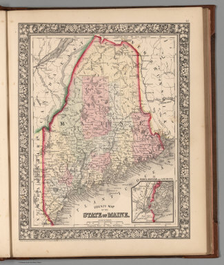
Author
Mitchell, Samuel Augustus Jr.
Full Title
County map of the State of Maine. Entered ... 1860 by S. Augustus Mitchell, Jr. ... Pennsylvania. (inset map) 13. Portland Har. and Vicinity.
Publisher
S.A. Mitchell Jr.
Author
Mitchell, Samuel Augustus Jr.
Full Title
New Hampshire and Vermont. Drawn and Eng. by W.H. Gamble. Entered ... 1862 by S. Augustus Mitchell, Jr. ... Pennsylvania.
Publisher
S.A. Mitchell Jr.
Author
Mitchell, Samuel Augustus Jr.
Full Title
County map of Massachusetts, Connecticut, and Rhode Island. Drawn & Engraved by W.H. Gamble Philad. Entered ... 1862 by S. Augustus Mitchell, Jr. ... Pennsylvania.
Publisher
S.A. Mitchell Jr.
Author
Mitchell, Samuel Augustus Jr.
Full Title
County map of the State of New York, New Hampshire, Vermont. Massachusetts, Rhode Id. and Connecticut. Drawn & Engraved by W. Williams Philadelphia. Entered ... 1860 by S. Augustus Mitchell, Jr. ... Pennsylvania. (inset maps)17. Harbor and Vicinity of New York, and 18. Harbor and Vicinity of Boston.
Publisher
S.A. Mitchell Jr.
Author
Mitchell, Samuel Augustus Jr.
Full Title
Plan of New York &c. Entered ... 1860 by S. Augustus Mitchell, Jr. ... Pennsylvania.
Publisher
S.A. Mitchell Jr.
Author
Mitchell, Samuel Augustus Jr.
Full Title
Plan of Boston. Entered ... 1860 by S. Augustus Mitchell, Jr. ... Pennsylvania. (inset map) Map of the Country arond Boston showing also its Harbor & Islands.
Publisher
S.A. Mitchell Jr.
Author
Mitchell, Samuel Augustus Jr.
Full Title
County map of the State of Pennsylvania. Drawn & Engraved by W.H. Gamble Philadelphia. Entered ... 1865 by S. Augustus Mitchell, Jr. ... Pennsylvania.
Publisher
S.A. Mitchell Jr.
Author
Mitchell, Samuel Augustus Jr.
Full Title
Plan of Philadelphia. Entered ... 1865 by S. Augustus Mitchell, Jr. ... Pennsylvania.
Publisher
S.A. Mitchell Jr.
Author
Mitchell, Samuel Augustus Jr.
Full Title
County map of New Jersey. (Scale: 1:1,100,000). County map of Maryland and Delaware. Drawn & Engraved by W.H. Gamble Philadelphia. (Scale: 1,550,000). Entered ... 1865 by S. Augustus Mitchell, Jr. ... Pennsylvania.
Publisher
S.A. Mitchell Jr.
Author
Mitchell, Samuel Augustus Jr.
Full Title
Plan of Baltimore. Entered ... 1860 by S. Augustus Mitchell, Jr. ... Pennsylvania.
Publisher
S.A. Mitchell Jr.
Author
Mitchell, Samuel Augustus Jr.
Full Title
Plan of the City of Washington. The Capital of the United States of America. Drawn & Engraved by W.H. Gamble. Entered ... 1861 by S. Augustus Mitchell, Jr. ... Pennsylvania.
Publisher
S.A. Mitchell Jr.
Author
Mitchell, Samuel Augustus Jr.
Full Title
County map of Virginia and West Virginia. Drawn & Engd. by W.H. Gamble Phila. Entered ... 1863 by S. Augustus Mitchell, Jr. ... Pennsylvania.
Publisher
S.A. Mitchell Jr.
Author
Mitchell, Samuel Augustus Jr.
Full Title
County map of Kentucky, and Tennessee. Entered ... 1860 by S. Augustus Mitchell, Jr. ... Pennsylvania.
Publisher
S.A. Mitchell Jr.
Author
Mitchell, Samuel Augustus Jr.
Full Title
County map of Georgia, and Alabama. Entered ... 1860 by S. Augustus Mitchell, Jr. ... Pennsylvania.
Publisher
S.A. Mitchell Jr.
Author
Mitchell, Samuel Augustus Jr.
Full Title
County map of North Carolina. (Scale: 1:2,800,000). Map of South Carolina. (Scale: 1:2,550,000). (inset) 31. Map of Charleston Harbor. County map of Florida. (Scale:1:3,700,000). Entered ... 1860 by S. Augustus Mitchell, Jr. ... Pennsylvania.
Publisher
S.A. Mitchell Jr.
Author
Mitchell, Samuel Augustus Jr.
Full Title
Map of Louisiana, Mississippi. And Arkansas. Entered ... 1860 by S. Augustus Mitchell, Jr. ... Pennsylvania.
Publisher
S.A. Mitchell Jr.
Author
Mitchell, Samuel Augustus Jr.
Full Title
Plan of New Orleans. Entered ... 1860 by S. Augustus Mitchell, Jr. ... Pennsylvania.
Publisher
S.A. Mitchell Jr.
Author
Mitchell, Samuel Augustus Jr.
Full Title
County map of Texas. (inset map) 35. Galveston Bay and Vicinity. Entered ... 1860 by S. Augustus Mitchell, Jr. ... Pennsylvania.
Publisher
S.A. Mitchell Jr.
Author
Mitchell, Samuel Augustus Jr.
Full Title
County map of Ohio and Indiana. Drawn & Engraved by W.H. Gamble Philad. Entered ... 1863 by S. Augustus Mitchell, Jr. ... Pennsylvania.
Publisher
S.A. Mitchell Jr.
Author
Mitchell, Samuel Augustus Jr.
Full Title
Plan of Cincinnati and Vicinity. Entered ... 1860 by S. Augustus Mitchell, Jr. ... Pennsylvania.
Publisher
S.A. Mitchell Jr.
Author
Mitchell, Samuel Augustus Jr.
Full Title
County map of the State of Illinois. (inset) 39. Plan of Chicago. Entered ... 1861 by S. Augustus Mitchell, Jr. ... Pennsylvania.
Publisher
S.A. Mitchell Jr.
|