|
Author
[Petermann, Augustus., Milner, Thomas]
Full Title
Geology. No. 3. Map of the World showing the distribution of Active Volcanoes and the Regions Visited by Earthquakes. Constructed by Augustus Petermann, F.R.G.S. London. Published by Orr and Compy., Amen Corner, Paternoster Row. (inset) Sketch of the extent and intensity of the Earthquake on the Rhine July 29, 1846....
Publisher
William S. Orr & Co.
Author
[Petermann, Augustus., Milner, Thomas]
Full Title
Hydrography. No. 4 & 5. Hydrographical Map of the World Chiefly with regard to the Division of the Ocean and the Boundaries of the River Systems. Constructed by Augustus Petermann, F.R.G.S. Engraved by John Dower, Pentonville, London. London: Published by Orr and Compy. Amen Corner, Paternoster Row.
Publisher
William S. Orr & Co.
Author
[Petermann, Augustus., Milner, Thomas]
Full Title
Hydrography. No. 6. Hydrographical Map of the World Showing the Currents, Temperature, etc. of the Ocean. Constructed by Augustus Petermann, F.R.G.S. Engraved by John Dower, Pentonville, London. London: Published by Orr and Compy. Amen Corner, Paternoster Row.
Publisher
William S. Orr & Co.
Author
[Petermann, Augustus., Milner, Thomas]
Full Title
Meteorology. No. 7. Meteorological Map of the World Showing the Distribution of the Temperature of the Air. Constructed by Augustus Petermann, F.R.G.S. Engraved by John Dower, Pentonville, London. London: Published by Orr and Compy. Amen Corner, Paternoster Row.
Publisher
William S. Orr & Co.
Author
[Petermann, Augustus., Milner, Thomas]
Full Title
Meteorology. No. 8. Map of the World showing the Distribution of the Winds and their Influence on Navigation. Constructed by Augustus Petermann, F.R.G.S. Engraved by John Dower, Pentonville, London. London: Published by Orr and Compy. Amen Corner, Paternoster Row.
Publisher
William S. Orr & Co.
Author
[Petermann, Augustus., Milner, Thomas]
Full Title
Meteorology. No.9. Hydrographic Map showing the distribution of the Rain over the Globe. Constructed by Augustus Petermann, F.R.G.S. Engraved by John Dower, Pentonville, London. London: Published by Orr and Compy. Amen Corner, Paternoster Row.
Publisher
William S. Orr & Co.
Author
[Petermann, Augustus., Milner, Thomas]
Full Title
Botanical Geography. No. 10. Botanical Map Showing the Distribution & Cultivation of some of the Most Important Plants over the Globe. Constructed by Augustus Petermann, F.R.G.S. Engraved by John Dower, Pentonville, London. London: Published by Orr and Compy. Amen Corner, Paternoster Row.
Publisher
William S. Orr & Co.
Author
[Petermann, Augustus., Milner, Thomas]
Full Title
Zoological Geography. No. 11. Zoological Map Showing the Distribution of the Principal Mammiferous Animals (Class Mammalia) Over the Globe. Constructed by Augustus Petermann, F.R.G.S. Engraved by John Dower, Pentonville, London. London: Published by Orr and Compy. Amen Corner, Paternoster Row.
Publisher
William S. Orr & Co.
Author
[Petermann, Augustus., Milner, Thomas]
Full Title
Zoological Geography. No. 12. Zoological Map Showing the Distribution of the Principal Birds and Reptiles (Aves et Reptilia) Over the Globe. Constructed by Augustus Petermann, F.R.G.S. Engraved by John Dower, Pentonville, London. London: Published by Orr and Compy. Amen Corner, Paternoster Row.
Publisher
William S. Orr & Co.
Author
[Petermann, Augustus., Milner, Thomas]
Full Title
Ethnography. No. 13. Ethnographical Map of the World showing the distribution of the Human Race in the Middle of the 19th Century. Constructed by Augustus Petermann, F.R.G.S. Engraved by John Dower, Pentonville, London. London: Published by Orr and Compy. Amen Corner, Paternoster Row.
Publisher
William S. Orr & Co.
Author
[Petermann, Augustus., Milner, Thomas]
Full Title
General Physical Geography. No.14. Physical Map of the British Isles. Showing their orography, climatology, and some Botantical and Zoological Features. Constructed by Augustus Petermann, F.R.G.S. Engraved by John Dower, Pentonville, London. London: Published by Orr and Compy. Amen Corner, Paternoster Row.
Publisher
William S. Orr & Co.
Author
[Petermann, Augustus., Milner, Thomas]
Full Title
Physical Map of Palestine and the Adjacent Countries. Constructed by Augustus Petermann, F.R.G.S. Engraved by John Dower, Pentonville, London. London: Published by Orr and Compy. Amen Corner, Paternoster Row.
Publisher
William S. Orr & Co.
Author
Johnson, A.J.
Full Title
Johnson's Map of The World Showing the Geographical Distribution & Range of The Principal Members of The Animal Kingdom (with) Bird Map. Johnson's Map of The World Illustrating the Productive Industry Of Various Countries, & exhibiting the principal features of Commerce And Navigation. Johnson's Map Showing the Principal Ocean Currents and Boundaries of the River Systems. Johnson's Map Illustrating the Principal Features of Meteorology (with) Rain Map. Johnson's Map Illustrating the Principal Features of the Land and the Co-tidal Lines. Johnson's Map Showing the Distribution and Limits of Cultivation of the Principal Plants Useful to Mankind.
Publisher
Johnson and Ward
Author
Johnson, A.J.
Full Title
Johnson's World on Mercators Projection Published by Johnson and Ward.
Publisher
Johnson and Ward
Author
Rand McNally and Company
Full Title
The population of the world, 1890. Rand, McNally & Co.'s miniature map of the world showing density of population, 1890. Area and population of foreign countries, compared with the United States, 1890. Indexed atlas of the world. (Engraved, printed and published by Rand, McNally & Company, Chicago and New York, U.S.A., 1897)
Publisher
Rand McNally
Author
Rand McNally and Company
Full Title
Rand, McNally & Co.'s. indexed atlas of the world map of the world on Mercator's projection. Showing the direction of the ocean currents. Copyright `895, by Rand, McNally & Co. ... Engravers, Chicago. (1897)
Publisher
Rand McNally
Author
Rand McNally and Company
Full Title
Rand, McNally & Company's indexed atlas of the world Western Hemisphere, Eastern Hemisphere. Rand McNally & Co.'s New map of the Western ... Eastern Hemisphere. Copyright 1892 by Rand, McNally & Co. ... Engravers, Chicago. (1897)
Publisher
Rand McNally
Author
Gray, Ormando Willis
Full Title
Mountains & Rivers.
Publisher
Stedman, Brown & Lyon
Author
Johnson, A.J.
Full Title
Johnson's Physical Map Showing the Principal Mountains, Plateaus, & Plains of The World by Prof. A. Guyot. Published by A. J. Johnson, New York. 7. 8. (Following maps at scale 1:85,000,000). Johnson's World Showing the Lines of Equal Magnetic Declination, Epoch 1856, By Prof. A. Guyot. Johnson's World Showing the Course of the Tidal Wave in the Three Great Oceans, and the Distribution of Volcanoes. By Prof. A. Guyot. Johnson's World, Showing the Distribution of the Principal Races of Man. By Prof. A. Guyot. Entered according to the Act of Congress, in the year 1870, by A.J. Johnson in the Clerk's Office of the District Court of the United States for the Southern District of New York.
Publisher
Alvin J. Johnson & Co.
Author
Johnson, A.J.
Full Title
Johnson's Ocean Currents and the Great River Basins of The World by Prof. A. Guyot. Published by A. J. Johnson, New York. Johnson's World, Showing the Distribution of the Temperature of the Air; By Prof. A. Guyot. Published by A. J. Johnson, New York. 9. 10. Entered according to the Act of Congress, in the year 1870, by A.J. Johnson in the Clerk's Office of the District Court of the United States for the Southern District of New York.
Publisher
Alvin J. Johnson & Co.
Author
Johnson, A.J.
Full Title
Johnson's World, Showing the Circulation of the Winds and the Course of Storms. By Prof. A. Guyot. Published by A. J. Johnson, New York. Johnson's World, Showing the Distribution of the Rain over the Globe By Prof. A. Guyot. Published by A. J. Johnson, New York. 11. 12. Entered according to the Act of Congress, in the year 1870, by A.J. Johnson in the Clerk's Office of the District Court of the United States for the Southern District of New York.
Publisher
Alvin J. Johnson & Co.
Author
Johnson, A.J.
Full Title
Johnson's World, Showing the Distribution of the Characteristic Forest Trees, Principal Useful Plants and Minerals. By Prof. A. Guyot. Published by A. J. Johnson, New York. 13. Entered according to the Act of Congress, in the year 1870, by A.J. Johnson in the Clerk's Office of the District Court of the United States for the Southern District of New York.
Publisher
Alvin J. Johnson & Co.
Author
Johnson, A.J.
Full Title
Johnson's Globular World, Published by Alvin J. Johnson & Co., New York. 16. 17. Western Hemisphere. Eastern Hemisphere. Entered according to the Act of Congress, in the year 1867, by A.J. Johnson in the Clerk's Office of the District Court of the United States for the Southern District of New York.
Publisher
Alvin J. Johnson & Co.
Author
Johnson, A.J.
Full Title
Johnson's World on Mercator's Projection, Published byAlvin J. Johnson & Co., New York. 18. 19. Entered according to the Act of Congress, in the year 1865, by A.J. Johnson in the Clerk's Office of the District Court of the United States for the Southern District of New York.
Publisher
Alvin J. Johnson & Co.
Author
Rand McNally and Company
Full Title
The World on Mercator's Projection.
Publisher
Rand McNally and Company
Author
Rand McNally and Company
Full Title
Commercial Atlas of America. Rand McNally, The Steamship Routes of The World.
Publisher
Rand McNally and Company
Author
Finley, Anthony
Full Title
The World On Mercator's Projection. Published by A. Finley Philada. Young & Delleker Sc.
Publisher
Anthony Finley
Author
Finley, Anthony
Full Title
Table of the Comparative Lengths of the Principal Rivers throughout the World ... Published by A. Finley Philada. Young & Delleker Sc.
Publisher
Anthony Finley
Author
Finley, Anthony
Full Title
Table of the Comparative Heights of the Principal Mountains &c. in the World ... Published by A. Finley Philada. Young & Delleker Sc.
Publisher
Anthony Finley
Author
Tanner, Henry S.
Full Title
A New Map Of The World on the Globular Projection By H.S. Tanner. Philadelphia. Published by H.S. Tanner 1833. Engd. by E.B. Dawson. Tanner's Universal Atlas.
Publisher
H.S. Tanner
Author
Tanner, Henry S.
Full Title
Heights Of The Principal Mountains In The World. F. Humphrys sculpt. Published by H.S. Tanner, Philadelphia. Entered ... 1836, by H.S. Tanner ... Pennsylvania. (above neat line) Tanner's Universal Atlas.
Publisher
H.S. Tanner
Author
Carey, Mathew
Full Title
A Map of the World from the best Authorities. Thackara & Vallance sc.
Publisher
Mathew Carey
Author
Carey, Mathew
Full Title
A Chart of the World According to Mercators Projection, Shewing the latest Discoveries of Capt. Cook.
Publisher
Mathew Carey
Author
Lucas, Fielding Jr.
Full Title
Comparative Lengths of the Principal Rivers throughout the World. B.T. Welch & Co. Sc. Drawn & Published by F. Lucas Jr. Baltimore
Publisher
Fielding Lucas Jr.
Author
[Rand McNally and Company, Schlitz Brewing Company]
Full Title
World. Rand-McNally's New 14 x 21 Map of the World. Copyright by Rand-McNally & Co. 1913.
Publisher
Rand McNally
Author
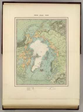
Johnston, Alexander Keith
Full Title
(Frontispiece) North Pole Chart by Keith Johnston F.R.G.S. Engraved, Printed and Published by W. & A.K. Johnston, Edinburgh & London. Frontispiece.
Publisher
W.& A.K. Johnston
Author
Johnston, Alexander Keith
Full Title
The World in Hemispheres. Western Hemisphere. Eastern Hemisphere. By Keith Johnston, F.R.S.E. Keith Johnston's General Atlas. Engraved, Printed, and Published by W. & A.K. Johnston, Edinburgh & London.
Publisher
W.& A.K. Johnston
Author
Johnston, Alexander Keith
Full Title
Chart of the World on Mercators Projection. Showing the direction of the ocean currents, with the routes and distances between principal ports. By Keith Johnston, F.R.S.E. Keith Johnston's General Atlas. Engraved, Printed, and Published by W. & A.K. Johnston, Edinburgh & London.
Publisher
W.& A.K. Johnston
Author
Moll, Herman, d. 1732
Full Title
A new map of the whole world with the trade winds according to ye latest and most exact observations. By H. Moll Geographer. Printed for Thos. Bowles Print and Map Seller next ye Chapter House in St. Pauls Churchyard, and John Bowles Print and Map Seller at the Black Horse in Cornhill, London (1736?)
Publisher
Thos. Bowles and John Bowles
Author
Mitchell, Samuel Augustus Jr.
Full Title
Map of the World on the Mercator projection, exhibiting the American Continent as its centre. Copyright by S. Augustus Mitchell 1884.
Publisher
Wm. M. Bradley & Bro.
Author
Mitchell, Samuel Augustus
Full Title
A New Map of the World on the Globular Projection. Philadelphia, Published By Charles Desilver, No. 714 Chestnut Street. Western Hemisphere. Eastern Hemisphere. 1. Entered according to Act of Congress in the year 1856 by Charles Desilver in the Clerk's office if the District Court of the Eastern District of Pennsylvania.
Publisher
Charles Desilver.
Author
[Schrader, Vivien St Martin, L.]
Full Title
Mappemonde. Carte 1. Chutes Annuelle des Pluies, Vents (Northern Hemisphere) Zones de Vegetation et Courants. Chute Annuelle des Pluies, Vents (Southern Hemisphere). Dresse et Desine par E. Giffault. Librarie Hachette. 9-31 Imp. Dufrenoy. Grave par Delaune, la lettre par Dumas-Vorxet.
Publisher
Librairie Hachette
Author
Tanner, Henry S.
Full Title
A New Map Of The World on the Globular Projection By H.S. Tanner. Philadelphia. Published by Carey & Hart 1843. Engd. by E.B. Dawson. Tanner's Universal Atlas.
Publisher
Carey and Hart
Author
Tanner, Henry S.
Full Title
Heights Of The Principal Mountains In The World. F. Humphrys sculpt. Published by Carey & Hart, Philadelphia. Entered ... 1836, by H.S. Tanner ... Pennsylvania. (above neat line) Tanner's Universal Atlas.
Publisher
Carey and Hart
Author
Rand McNally and Company
Full Title
(World)
Publisher
Rand McNally and Company
Author
Johnston, Alexander Keith
Full Title
(Frontispiece to) North Pole Chart by Keith Johnston F.R.G.S. Engraved, Printed and Published by W. & A.K. Johnston, Edinburgh & London. Frontispiece.
Publisher
W.& A.K. Johnston
Author
Johnston, Alexander Keith
Full Title
The World in Hemispheres. Western Hemisphere. Eastern Hemisphere. By Keith Johnston, F.R.S.E. Keith Johnston's General Atlas. Engraved, Printed, and Published by W. & A.K. Johnston, Edinburgh & London.
Publisher
W.& A.K. Johnston
Author
Johnston, Alexander Keith
Full Title
Chart of the World on Mercators Projection. Showing the direction of the ocean currents, with the routes and distances between principal ports. By Keith Johnston, F.R.S.E. Keith Johnston's General Atlas. Engraved, Printed, and Published by W. & A.K. Johnston, Edinburgh & London.
Publisher
W.& A.K. Johnston
Author
Vivien de St Martin, L.
Full Title
Mappe -Monde en deux Hemispheres. Par L. Vivien Geographe. Grave par Giraldon-Bovinet, Paris. Chez Menard et Desenne, Rue Git le Coeur, No. 8. 1825.
Publisher
Vivien de St Martin, L.
|