|
Author
[Great Britain. Ordnance Survey, Mudge, William (1762-1820), Colby, Thomas, Baker, Benjamin, Great Britain. Board of Ordnance]
Full Title
92. Skipton.
Publisher
[W. Mudge; Ordnance Survey, Thomas Colby (1784-1852)]
Author
[Great Britain. Ordnance Survey, Mudge, William (1762-1820), Colby, Thomas, Baker, Benjamin, Great Britain. Board of Ordnance]
Full Title
93. York.
Publisher
[W. Mudge; Ordnance Survey, Thomas Colby (1784-1852)]
Author
[Great Britain. Ordnance Survey, Mudge, William (1762-1820), Colby, Thomas, Baker, Benjamin, Great Britain. Board of Ordnance]
Full Title
94. Beverley.
Publisher
[W. Mudge; Ordnance Survey, Thomas Colby (1784-1852)]
Author
[Great Britain. Ordnance Survey, Mudge, William (1762-1820), Colby, Thomas, Baker, Benjamin, Great Britain. Board of Ordnance]
Full Title
95. Scarborough.
Publisher
[W. Mudge; Ordnance Survey, Thomas Colby (1784-1852)]
Author
[Great Britain. Ordnance Survey, Mudge, William (1762-1820), Colby, Thomas, Baker, Benjamin, Great Britain. Board of Ordnance]
Full Title
96. Helmsley.
Publisher
[W. Mudge; Ordnance Survey, Thomas Colby (1784-1852)]
Author
[Great Britain. Ordnance Survey, Mudge, William (1762-1820), Colby, Thomas, Baker, Benjamin, Great Britain. Board of Ordnance]
Full Title
97. Richmond.
Publisher
[W. Mudge; Ordnance Survey, Thomas Colby (1784-1852)]
Author
[Great Britain. Ordnance Survey, Mudge, William (1762-1820), Colby, Thomas, Baker, Benjamin, Great Britain. Board of Ordnance]
Full Title
98. Kendal.
Publisher
[W. Mudge; Ordnance Survey, Thomas Colby (1784-1852)]
Author
[Great Britain. Ordnance Survey, Mudge, William (1762-1820), Colby, Thomas, Baker, Benjamin, Great Britain. Board of Ordnance]
Full Title
99. Ravenglass.
Publisher
[W. Mudge; Ordnance Survey, Thomas Colby (1784-1852)]
Author
[Great Britain. Ordnance Survey, Mudge, William (1762-1820), Colby, Thomas, Baker, Benjamin, Great Britain. Board of Ordnance]
Full Title
100. Isle of Man.
Publisher
[W. Mudge; Ordnance Survey, Thomas Colby (1784-1852)]
Author
[Great Britain. Ordnance Survey, Mudge, William (1762-1820), Colby, Thomas, Baker, Benjamin, Great Britain. Board of Ordnance]
Full Title
101. Cockermouth.
Publisher
[W. Mudge; Ordnance Survey, Thomas Colby (1784-1852)]
Author
[Great Britain. Ordnance Survey, Mudge, William (1762-1820), Colby, Thomas, Baker, Benjamin, Great Britain. Board of Ordnance]
Full Title
102. Appleby.
Publisher
[W. Mudge; Ordnance Survey, Thomas Colby (1784-1852)]
Author
[Great Britain. Ordnance Survey, Mudge, William (1762-1820), Colby, Thomas, Baker, Benjamin, Great Britain. Board of Ordnance]
Full Title
103. Durham.
Publisher
[W. Mudge; Ordnance Survey, Thomas Colby (1784-1852)]
Author
[Great Britain. Ordnance Survey, Mudge, William (1762-1820), Colby, Thomas, Baker, Benjamin, Great Britain. Board of Ordnance]
Full Title
104. Whitby.
Publisher
[W. Mudge; Ordnance Survey, Thomas Colby (1784-1852)]
Author
[Great Britain. Ordnance Survey, Mudge, William (1762-1820), Colby, Thomas, Baker, Benjamin, Great Britain. Board of Ordnance]
Full Title
105. Newcastle.
Publisher
[W. Mudge; Ordnance Survey, Thomas Colby (1784-1852)]
Author
[Great Britain. Ordnance Survey, Mudge, William (1762-1820), Colby, Thomas, Baker, Benjamin, Great Britain. Board of Ordnance]
Full Title
106. Haltwhistle.
Publisher
[W. Mudge; Ordnance Survey, Thomas Colby (1784-1852)]
Author
[Great Britain. Ordnance Survey, Mudge, William (1762-1820), Colby, Thomas, Baker, Benjamin, Great Britain. Board of Ordnance]
Full Title
107. Carlisle.
Publisher
[W. Mudge; Ordnance Survey, Thomas Colby (1784-1852)]
Author
[Great Britain. Ordnance Survey, Mudge, William (1762-1820), Colby, Thomas, Baker, Benjamin, Great Britain. Board of Ordnance]
Full Title
108. Wooler.
Publisher
[W. Mudge; Ordnance Survey, Thomas Colby (1784-1852)]
Author
[Great Britain. Ordnance Survey, Mudge, William (1762-1820), Colby, Thomas, Baker, Benjamin, Great Britain. Board of Ordnance]
Full Title
109. Alnwick.
Publisher
[W. Mudge; Ordnance Survey, Thomas Colby (1784-1852)]
Author
[Great Britain. Ordnance Survey, Mudge, William (1762-1820), Colby, Thomas, Baker, Benjamin, Great Britain. Board of Ordnance]
Full Title
110. Berwick.
Publisher
[W. Mudge; Ordnance Survey, Thomas Colby (1784-1852)]
Author
Melish, John
Full Title
Map of the American Coast, from Lynhaven Bay to Narraganset Bay, by John Melish.
Publisher
John Melish
Author
Melish, John
Full Title
Map of the Seat of War in North America. J. Melish del. H.S. Tanner, Dirext. Entered as the Art Directs, and Published by John Melish, Philadelphia.
Publisher
John Melish
Author
Melish, John
Full Title
View of the Country round the Falls of Niagara.
Publisher
John Melish
Author
Melish, John
Full Title
East End of Lake Ontario.
Publisher
John Melish
Author
Melish, John
Full Title
Plan of Montreal, with a Map of the Islands & adjoining Country.
Publisher
John Melish
Author
Melish, John
Full Title
Southern Section of the United States including Florida &c. by John Melish. Entered ... by John Melish ... 1 March 1813.
Publisher
John Melish
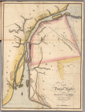
Author
Melish, John
Full Title
Map of Detroit River and Adjacent Country, From an Original Drawing, by a British Engineer.
Publisher
John Melish
Author
Melish, John
Full Title
Plan of Quebec and Adjacent Country Shewing The principal Encampments & Works of the British & French Armies during the Siege by General Wolfe in 1759. Reduced from the M.S.S. Map of Capt. J.B. Glegg, by John Melish.
Publisher
John Melish
Author
[Woerl, Joseph Edmund, Herder, Bartholomew]
Full Title
Freiburg. Entworfen und bearbeitet von Woerl, in Stein gestochen unter seiner Leitung -1831. Im Herder'schen Kunst- Institut in Freiburg im Breisgau. (to accompany) Karte der Schweiz, von Dr. I. Woerl. Lithographie von B. Herder in Freiburg im Breisgau.
Publisher
B. Herder
Author
[Woerl, Joseph Edmund, Herder, Bartholomew]
Full Title
Schaffhausen. Entworfen und bearbeitet von Woerl, gestochen unter seiner Leitung Lithographie von B. Herder in Freiburg im Breisgau. (to accompany) Karte der Schweiz, von Dr. I. Woerl. Lithographie von B. Herder in Freiburg im Breisgau.
Publisher
B. Herder
Author
[Woerl, Joseph Edmund, Herder, Bartholomew]
Full Title
Constanz - Lindau. Entworfen und bearbeitet von Woerl, gestochen unter seiner Leitung 1834. Lithographie von B. Herder in Freiburg im Breisgau. (to accompany) Karte der Schweiz, von Dr. I. Woerl. Lithographie von B. Herder in Freiburg im Breisgau.
Publisher
B. Herder
Author
[Woerl, Joseph Edmund, Herder, Bartholomew]
Full Title
Fussen. Entworfen und bearbeitet von Woerl, gestochen unter seiner Leitung 1835. Im Herder'schen Kunst- Institut in Freiburg im Breisgau. (to accompany) Karte der Schweiz, von Dr. I. Woerl. Lithographie von B. Herder in Freiburg im Breisgau.
Publisher
B. Herder
Author
[Woerl, Joseph Edmund, Herder, Bartholomew]
Full Title
Besancon. Entworfen und bearbeitet von Woerl, gestochen unter seiner Leitung 1835. Lithographie von B. Herder zu Freiburg im Breisgau. (to accompany) Karte der Schweiz, von Dr. I. Woerl. Lithographie von B. Herder in Freiburg im Breisgau.
Publisher
B. Herder
Author
[Woerl, Joseph Edmund, Herder, Bartholomew]
Full Title
Bern. Entworfen und bearbeitet von Woerl, gestochen unter seiner Leitung 1834. Lithographie von B. Herder in Freiburg im Breisgau. (to accompany) Karte der Schweiz, von Dr. I. Woerl. Lithographie von B. Herder in Freiburg im Breisgau.
Publisher
B. Herder
Author
[Woerl, Joseph Edmund, Herder, Bartholomew]
Full Title
Zurich. Entworfen und bearbeitet von Woerl, gestochen unter seiner Leitung 1834. Lithographie von B. Herder in Freiburg im Breisgau. (to accompany) Karte der Schweiz, von Dr. I. Woerl. Lithographie von B. Herder in Freiburg im Breisgau.
Publisher
B. Herder
Author
[Woerl, Joseph Edmund, Herder, Bartholomew]
Full Title
Waldenstadt. Entworfen und bearbeitet von Woerl, gestochen unter seiner Leitung 1835. Lithographie von B. Herder in Freiburg im Breisgau. (to accompany) Karte der Schweiz, von Dr. I. Woerl. Lithographie von B. Herder in Freiburg im Breisgau.
Publisher
B. Herder
Author
[Woerl, Joseph Edmund, Herder, Bartholomew]
Full Title
Meran. Entworfen und bearbeitet von Woerl, gestochen unter seiner Leitung. Lithographie von B. Herder in Freiburg im Breisgau. (to accompany) Karte der Schweiz, von Dr. I. Woerl. Lithographie von B. Herder in Freiburg im Breisgau.
Publisher
B. Herder
Author
[Woerl, Joseph Edmund, Herder, Bartholomew]
Full Title
Lausanne. Entworfen und bearbeitet von Woerl, gestochen unter seiner Leitung 1835. Lithographie von B. Herder zu Freiburg im Breisgau. (to accompany) Karte der Schweiz, von Dr. I. Woerl. Lithographie von B. Herder in Freiburg im Breisgau.
Publisher
B. Herder
Author
[Woerl, Joseph Edmund, Herder, Bartholomew]
Full Title
Freyburg in der Schweiz. Entworfen und bearbeitet von Woerl, gestochen unter seiner Leitung 1835. Lithographie von B. Herder zu Freiburg im Breisgau. (to accompany) Karte der Schweiz, von Dr. I. Woerl. Lithographie von B. Herder in Freiburg im Breisgau.
Publisher
B. Herder
Author
[Woerl, Joseph Edmund, Herder, Bartholomew]
Full Title
Locarno. Entworfen und bearbeitet von Woerl, gestochen unter seiner Leitung 1835. Lithographie von B. Herder zu Freiburg im Breisgau. (to accompany) Karte der Schweiz, von Dr. I. Woerl. Lithographie von B. Herder in Freiburg im Breisgau.
Publisher
B. Herder
Author
[Woerl, Joseph Edmund, Herder, Bartholomew]
Full Title
Chiavenna. Entworfen und bearbeitet von Woerl, gestochen unter seiner Leitung 1835. Lithographie von B. Herder zu Freiburg im Breisgau. (to accompany) Karte der Schweiz, von Dr. I. Woerl. Lithographie von B. Herder in Freiburg im Breisgau.
Publisher
B. Herder
Author
[Woerl, Joseph Edmund, Herder, Bartholomew]
Full Title
Trient. Entworfen und bearbeitet von Woerl, gestochen unter seiner Leitung. Lithographie von B. Herder in Freiburg im Breisgau. (to accompany) Karte der Schweiz, von Dr. I. Woerl. Lithographie von B. Herder in Freiburg im Breisgau.
Publisher
B. Herder
Author
[Woerl, Joseph Edmund, Herder, Bartholomew]
Full Title
Geneve. Entworfen und bearbeitet von Woerl, gestochen unter seiner Leitung 1835. Lithographie von B. Herder in Freiburg im Breisgau. (to accompany) Karte der Schweiz, von Dr. I. Woerl. Lithographie von B. Herder in Freiburg im Breisgau.
Publisher
B. Herder
Author
[Woerl, Joseph Edmund, Herder, Bartholomew]
Full Title
Aosta. Entworfen und bearbeitet von Woerl, gestochen unter seiner Leitung 1835. Lithographie von B. Herder zu Freiburg im Breisgau. (to accompany) Karte der Schweiz, von Dr. I. Woerl. Lithographie von B. Herder in Freiburg im Breisgau.
Publisher
B. Herder
Author
[Woerl, Joseph Edmund, Herder, Bartholomew]
Full Title
Biella. Entworfen und bearbeitet von Woerl, gestochen unter seiner Leitung 1835. Lithographie von B. Herder zu Freiburg im Breisgau. (to accompany) Karte der Schweiz, von Dr. I. Woerl. Lithographie von B. Herder in Freiburg im Breisgau.
Publisher
B. Herder
Author
[Woerl, Joseph Edmund, Herder, Bartholomew]
Full Title
Milano. Entworfen und bearbeitet von Woerl, gestochen unter seiner Leitung 1835. Lithographie von B. Herder zu Freiburg im Breisgau. (to accompany) Karte der Schweiz, von Dr. I. Woerl. Lithographie von B. Herder in Freiburg im Breisgau.
Publisher
B. Herder
Author
[Woerl, Joseph Edmund, Herder, Bartholomew]
Full Title
Verona. Entworfen und bearbeitet von Woerl, gestochen unter seiner Leitung 1835. Lithographie von B. Herder zu Freiburg im Breisgau. (to accompany) Karte der Schweiz, von Dr. I. Woerl. Lithographie von B. Herder in Freiburg im Breisgau.
Publisher
B. Herder
Author
[Codazzi, Agustín, 1793-1859, Paz, Manuel María, 1820-1902]
Full Title
Carta de Colombia, que representa la puta de los conquistadores y exploradores en el territorio que forma la Republica la posicion de la Tribus y las primeras findacionesy y divisiones politicas. Grabado por Erhard Hermanos, 8 Calle Nicole, Paris. (to accompany) Atlas geografico e historico de la Republica de Colombia (Antigua Nueva Granada).
Publisher
A. Lahure
Author
[Codazzi, Agustín, 1793-1859, Paz, Manuel María, 1820-1902]
Full Title
Carta de Colombia, que representa la primeras divisiones coloniales. Grabado por Erhard Hermanos, 8 Calle Nicole, Paris. (to accompany) Atlas geografico e historico de la Republica de Colombia (Antigua Nueva Granada).
Publisher
A. Lahure
Author
[Codazzi, Agustín, 1793-1859, Paz, Manuel María, 1820-1902]
Full Title
Carta de las presidencias de Santafe y Quito. Grabado por Erhard Hermanos, 8 Calle Nicole, Paris. (to accompany) Atlas geografico e historico de la Republica de Colombia (Antigua Nueva Granada).
Publisher
A. Lahure
Author
[Codazzi, Agustín, 1793-1859, Paz, Manuel María, 1820-1902]
Full Title
Carta del Vireinato de Santafe y de la Capitania General de Venezuela. Grabado por Erhard Hermanos, 8 Calle Nicole, Paris. (to accompany) Atlas geografico e historico de la Republica de Colombia (Antigua Nueva Granada).
Publisher
A. Lahure
|