|
Author
Popple, Henry
Full Title
A Map of the British Empire in America with the French and Spanish Settlements adjacent thereto. by Henry Popple. (Sheet 16).
Publisher
Willm. Henry Toms & R.W. Seale.
Author
Popple, Henry
Full Title
A Map of the British Empire in America with the French and Spanish Settlements adjacent thereto. by Henry Popple. (Sheet 17).
Publisher
Willm. Henry Toms & R.W. Seale.
Author
Popple, Henry
Full Title
A Map of the British Empire in America with the French and Spanish Settlements adjacent thereto. by Henry Popple. (Sheet 18).
Publisher
Willm. Henry Toms & R.W. Seale.
Author
Popple, Henry
Full Title
A Map of the British Empire in America with the French and Spanish Settlements adjacent thereto. by Henry Popple. (Sheet 19).
Publisher
Willm. Henry Toms & R.W. Seale.
Author
Popple, Henry
Full Title
A Map of the British Empire in America with the French and Spanish Settlements adjacent thereto. by Henry Popple. (Sheet 20).
Publisher
Willm. Henry Toms & R.W. Seale.
Author
Popple, Henry
Full Title
America Septentrionalis. A Map of the British Empire in America with the French and Spanish Settlements adjacent thereto. by Henry Popple. To the Queen's Most Excellent Majesty This Map is most humbly Inscribed by Your Majesty's most Dutiful, most Obedient, and most Humble Servant Henry Popple. W.H. Toms Sculp.
Publisher
Willm. Henry Toms & R.W. Seale
Author
Popple, Henry
Full Title
A Map of the British Empire in America with the French and Spanish Settlements adjacent thereto. by Henry Popple. (Sheet 1).
Publisher
Willm. Henry Toms & R.W. Seale
Author
Popple, Henry
Full Title
A Map of the British Empire in America with the French and Spanish Settlements adjacent thereto. by Henry Popple. (Sheet 2).
Publisher
Willm. Henry Toms & R.W. Seale
Author
Popple, Henry
Full Title
A Map of the British Empire in America with the French and Spanish Settlements adjacent thereto. by Henry Popple. (Sheet 3).
Publisher
Willm. Henry Toms & R.W. Seale
Author
Popple, Henry
Full Title
A Map of the British Empire in America with the French and Spanish Settlements adjacent thereto. by Henry Popple. (Sheet 4).
Publisher
Willm. Henry Toms & R.W. Seale
Author
Popple, Henry
Full Title
A Map of the British Empire in America with the French and Spanish Settlements adjacent thereto. by Henry Popple. (Sheet 5).
Publisher
Willm. Henry Toms & R.W. Seale
Author
Popple, Henry
Full Title
A Map of the British Empire in America with the French and Spanish Settlements adjacent thereto. by Henry Popple. (Sheet 6).
Publisher
Willm. Henry Toms & R.W. Seale
Author
Popple, Henry
Full Title
A Map of the British Empire in America with the French and Spanish Settlements adjacent thereto. by Henry Popple. (Sheet 7).
Publisher
Willm. Henry Toms & R.W. Seale
Author
Popple, Henry
Full Title
A Map of the British Empire in America with the French and Spanish Settlements adjacent thereto. by Henry Popple. (Sheet 8).
Publisher
Willm. Henry Toms & R.W. Seale
Author
Popple, Henry
Full Title
A Map of the British Empire in America with the French and Spanish Settlements adjacent thereto. by Henry Popple. (Sheet 9).
Publisher
Willm. Henry Toms & R.W. Seale
Author
Popple, Henry
Full Title
A Map of the British Empire in America with the French and Spanish Settlements adjacent thereto. by Henry Popple. (Sheet 10).
Publisher
Willm. Henry Toms & R.W. Seale
Author
Popple, Henry
Full Title
A Map of the British Empire in America with the French and Spanish Settlements adjacent thereto. by Henry Popple. (Sheet 11).
Publisher
Willm. Henry Toms & R.W. Seale
Author
Popple, Henry
Full Title
A Map of the British Empire in America with the French and Spanish Settlements adjacent thereto. by Henry Popple. (Sheet 12).
Publisher
Willm. Henry Toms & R.W. Seale
Author
Popple, Henry
Full Title
A Map of the British Empire in America with the French and Spanish Settlements adjacent thereto. by Henry Popple. (Sheet 13).
Publisher
Willm. Henry Toms & R.W. Seale
Author
Popple, Henry
Full Title
A Map of the British Empire in America with the French and Spanish Settlements adjacent thereto. by Henry Popple. (Sheet 14).
Publisher
Willm. Henry Toms & R.W. Seale
Author
Popple, Henry
Full Title
A Map of the British Empire in America with the French and Spanish Settlements adjacent thereto. by Henry Popple. (Sheet 15).
Publisher
Willm. Henry Toms & R.W. Seale
Author
Popple, Henry
Full Title
A Map of the British Empire in America with the French and Spanish Settlements adjacent thereto. by Henry Popple. (Sheet 16).
Publisher
Willm. Henry Toms & R.W. Seale
Author
Popple, Henry
Full Title
A Map of the British Empire in America with the French and Spanish Settlements adjacent thereto. by Henry Popple. (Sheet 17).
Publisher
Willm. Henry Toms & R.W. Seale
Author
Popple, Henry
Full Title
A Map of the British Empire in America with the French and Spanish Settlements adjacent thereto. by Henry Popple. (Sheet 18).
Publisher
Willm. Henry Toms & R.W. Seale
Author
Popple, Henry
Full Title
A Map of the British Empire in America with the French and Spanish Settlements adjacent thereto. by Henry Popple. (Sheet 20).
Publisher
Willm. Henry Toms & R.W. Seale
Author
Popple, Henry
Full Title
A Map of the British Empire in America with the French and Spanish Settlements adjacent thereto. by Henry Popple. (Sheet 19).
Publisher
Willm. Henry Toms & R.W. Seale
Author
Paz Soldan, Mariano Felipe, 1821-1886
Full Title
Cuadro general de alturas comparativas del Peru. Paz Soldan. Geografia del Peru. F. Delamare, 1865 Paris. Paris, Imp. Monrocq, Rue Suger 3. (Paris: Libreria de Augusto Durand, 1865)
Publisher
Libreria de Augusto Durand.
Author
Paz Soldan, Mariano Felipe, 1821-1886
Full Title
Linea que representa los temblores sentidos en Arequipa desde hasta 1845. Corte vertical del camino del Pacifico al Huallaga. Corte vertical del camino de Arica al Cuzco. Plano del Pongo de Manseriche. Vista segun el corte vertical. Paz Soldan. Geografia del Peru. Grabado por Delamare, Paris, Calle St. Andre des Arts 45. Paris, Imp. Janson, r. Antne. Dubois, 6. (Paris: Libreria de Augusto Durand, 1865)
Publisher
Libreria de Augusto Durand.
Author
[Maw, Henry Lister, Paz Soldan, Mariano Felipe, 1821-1886]
Full Title
Lecho del Rio Amazonas segun los sondeos de Lister Maw. Corte vertical del camino de Lima al Cerro de Pasco. Paz Soldan. Geografia del Peru. Grabado por Delamare, Calle St. Andre des Arts 45, Paris. Imp. Janson - Paris. (Paris: Libreria de Augusto Durand, 1865)
Publisher
Libreria de Augusto Durand.
Author
Paz Soldan, Mariano Felipe, 1821-1886
Full Title
Fondeaderos de algunos puertos del Peru. Payta. Ferrol. Huacho. Callao. Pisco. Quilca. Islay. Mollendo. Guata. Noratos. Ilo. Arica. Paz Soldan. Geografia del Peru. Grabado por Erhard, Paris, Calle Duguay-Trouin 12. Paris, Imp. Janson. (Paris: Libreria de Augusto Durand, 1865)
Publisher
Libreria de Augusto Durand.
Author
[Castelnau, Francis, comte de, 1812-1880, Paz Soldan, Mariano Felipe, 1821-1886]
Full Title
Corte geologico de la parte sud del Peru que comprende los Departamentos de Puno, Arequipa, Ica y Lima por El Conde Francisco de Castelnau. Paz Soldan. Geografia del Peru. Grabado por Delamare, calle St. Andre des Arts, 45, Paris. Paris, Imprenta Monrocq, calle Suger, 3. (Paris: Libreria de Augusto Durand, 1865)
Publisher
Libreria de Augusto Durand.
Author
Restrepo, Jose Manuel, 1781-1863
Full Title
Carta del Departamento del Ismo. Gravado en Paris por Darmet, 1827. Escrito por Hacq. (Por Jose Manuel Restrepo. Paris, Libreria Americana, 1827)
Publisher
Libreria Americana
Author
Restrepo, Jose Manuel, 1781-1863
Full Title
Carta del Departamento de la Magdalena. Gravado en Paris por Darmet, 1827. Escrito por Hacq. (Por Jose Manuel Restrepo. Paris, Libreria Americana, 1827)
Publisher
Libreria Americana
Author
Restrepo, Jose Manuel, 1781-1863
Full Title
Carta del Departamento del Zulia. Gravado en Paris por Darmet, 1827. Escrito por Hacq. (Por Jose Manuel Restrepo. Paris, Libreria Americana, 1827)
Publisher
Libreria Americana
Author
Restrepo, Jose Manuel, 1781-1863
Full Title
Carta del Departamento de Venezuela. Gravado en Paris por Darmet, 1827. Escrito por Hacq. (Por Jose Manuel Restrepo. Paris, Libreria Americana, 1827)
Publisher
Libreria Americana
Author
Restrepo, Jose Manuel, 1781-1863
Full Title
Carta del Departamento del Orinoco o de Maturin. Gravado en Paris por Darmet, 1827. Escrito por Hacq. (Por Jose Manuel Restrepo. Paris, Libreria Americana, 1827)
Publisher
Libreria Americana
Author
Restrepo, Jose Manuel, 1781-1863
Full Title
Carta del Departamento del Cauca. Gravado en Paris por Darmet, 1827. Escrito por Hacq. (Por Jose Manuel Restrepo. Paris, Libreria Americana, 1827)
Publisher
Libreria Americana
Author
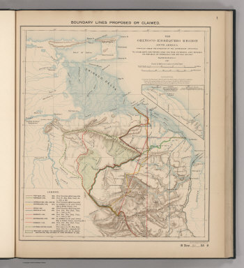
Venezuela-British Guiana Boundary Commission
Full Title
Boundary Lines Proposed or Claimed. 1. S Doc 91 55 2. The Orinoco - Essequibo Region, South America Compiled under the Direction of the Commission Appointed "To Investigate and Report upon the True Divisional Line between the Republic of Venezuela and British Guiana." 1897. Lith. by A. Hoen & Co., Baltimore, MD.
Publisher
United States of America
Author
Venezuela-British Guiana Boundary Commission
Full Title
Forests and Savannas. 2. S Doc 91 55 2. The Orinoco - Essequibo Region, South America, Compiled under the Direction of the Commission Appointed "To Investigate and Report upon the True Divisional Line between the Republic of Venezuela and British Guiana." Washington D.C. 1897. Lith. by A. Hoen & Co., Baltimore, MD.
Publisher
United States of America
Author
Wheeler, G.M.
Full Title
Parts Of Central & Western Arizona - Atlas Sheet No. 75. Issued Feb'y. 15 1877. Weyss, Herman & Lang Del. Expeditions of 1871, 1872 & 1873, Under the Command of 1st. Lieut. Geo. M. Wheeler, Corps of Engineers, U.S. Army. Geological Assistants: Prof. Jul. Marcou, G.K. Gilbert, A.R. Marvine. U.S. Geographical Surveys West Of The 100th Meridian.
Publisher
U.S.
Author
Wheeler, G.M.
Full Title
Parts Of Eastern Arizona And Western New Mexico Atlas Sheet No. 76. Issued Mar. 18th 1876. The Graphic Co. Photo-Lith. 39 & 41 Park Place, N.Y. Weyss, Herman & Lang Del. Expeditions of 1871 1873 & 1875 Under the Command of 1st. Lieut. Geo. M. Wheeler, Corps of Engineers, U.S. Army. U.S. Geographical Surveys West Of The 100th Meridian.
Publisher
U.S.
Author
Wheeler, G.M.
Full Title
Parts Of Eastern Arizona And Western New Mexico Atlas Sheet No. 76. Issued Feb'y. 15 1877. Weyss, Herman & Lang Del. Expeditions of 1871, 1872 & 1873, Under the Command of 1st. Lieut. Geo. M. Wheeler, Corps of Engineers, U.S. Army. Geological Assistants: G.K. Gilbert, A.R. Marvine, E.E. Howell. U.S. Geographical Surveys West Of The 100th Meridian.
Publisher
U.S.
Author
Rand McNally and Company
Full Title
Rand, McNally & Co.'s Map of the World.
Publisher
Rand McNally
Author
Wheeler, G.M.
Full Title
Part of Central New Mexico, Atlas Sheet No. 77. Issued June 30th 1882. Weyss, Spiller and Rock. Del. Expeditions of 1873, 74, 75, 76, 77 & '78 Under the Command of 1st. Lieut. Geo. M. Wheeler, Corps of Engineers, U.S. Army. Executive Officers and Field Astronomers, U.S. Army: 2nd Lieut. A.H. Russell, 3rd Cav.; 1st Lieuts. C.C. Morrison 6th Cav., P.M. Price Corps of Engr's. and Rogers Birnie, Jr. 13th Infy. Topographical Assistants: Max Schmidt, E.J. Sommer, Gilbert Thompson, Frank Carpenter, F.A. Clark, Anton Karl, F.O. Maxson and E. Gillette. U.S. Geographical Surveys West Of The 100th Meridian.
Publisher
U.S.
Author
Rand McNally and Company
Full Title
Rand, McNally & Co.'s Africa.
Publisher
Rand McNally
Author
Rand McNally and Company
Full Title
Rand, McNally & Co.'s South America.
Publisher
Rand McNally
Author
Rand McNally and Company
Full Title
Rand, McNally & Co.'s United States.
Publisher
Rand McNally
Author
Rand McNally and Company
Full Title
Rand, McNally & Co.'s Alaska.
Publisher
Rand McNally
Author
Rand McNally and Company
Full Title
Rand, McNally & Co.'s West Indies.
Publisher
Rand McNally
|