Search Results:

1850 Covers: Kentucky And Tennessee Pocket Map (Covers to) Kentucky And Tennessee. By H … |

1850 Kentucky And Tennessee Pocket Map Kentucky And Tennessee. By H.S. Tanner. … |

1850 Map of the United States. Separate Map Map Of The United States And Their Terri … |

1850 Map of the United States, 1850 Separate Map Map of the United States. Hartd., Publis … |

1850 Map Of Mexico, Including Yucatan & Upper … Separate Map Map Of Mexico, Including Yucatan & Upper … |

1850 The World, on Mercator's Projection Separate Map The World, on Mercator's Projection: By … |

1850 Chart Prepared By James B. Moore Separate Map Chart Prepared By James B. Moore, To Acc … |

1850 Map of North America. Manuscript Map Map of North America. Jessie E. Williams … |

1850 Map of South America Manuscript Map Map of South America. Jessie E. Williams … |

1850 Covers: Guide Through The United States Guide Book (Covers to) Mitchell's New Traveller's G … |

1850 Title Page: Guide Through The United Sta … Guide Book (Title Page to) Mitchell's New Traveller … |

1850 Guide Through The United States Guide Book Mitchell's New Traveller's Guide Through … |

1850 Covers: Kentucky Pocket Map (Covers to) The Tourist's Pocket Map Of … |

1850 Kentucky Pocket Map The Tourist's Pocket Map Of The State Of … |

1850 Covers: New England, New-York And Canada Pocket Map (Covers to) Sherman & Smith's Railroad, … |

1850 New England, New-York And Canada Pocket Map Sherman & Smith's Railroad, Steam Boat & … |
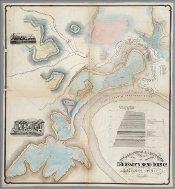
1850 Bradys Bend, Armstrong County Pennsylvan … Separate Map Topographical & Geological Map Of The Pr … |

1850 Pennsylvania's Great Highway And Its Tri … Separate Map Pennsylvania's Great Highway And Its Tri … |

1850 Covers: Arrowsmith's New Atlas 1850 World Atlas (Covers to) Outlines Of The World. By A. … |
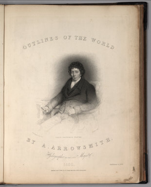
1850 Title Page: Outlines Of The World. By A. … World Atlas (Title Page to) Outlines Of The World. B … |

1850 England World Atlas England. Re- Published by G.F. Cruchley, … |

1850 Holland World Atlas Holland. Re- Published, Jany st. 1845, b … |

1850 Holland and Belgium World Atlas Holland and Belgium. Re- Published by G. … |

1850 France and Belgium World Atlas France and Belgium. Re- Published by G.F … |

1850 Germany World Atlas Germany. Re- Published by G.F. Cruchley, … |

1850 Northern Italy World Atlas N. Italy. Re- Published by G.F. Cruchley … |

1850 Covers: Mitchell's New Universal Atlas. World Atlas (Covers to) A New Universal Atlas Contai … |

1850 Text: (Anonymous Handwritten Notes about … World Atlas (Text Page) (Anonymous Handwritten Notes … |

1850 Frontispiece: Lengths of the Principal R … World Atlas (Frontispiece) Lengths of the Principal … |

1850 Title: Mitchell's New Universal Atlas. World Atlas (Title Page) A New Universal Atlas Conta … |

1850 Index: Table of Contents. World Atlas (Index Page) Table of Contents. |

1850 World on the Globular Projection. Wester … World Atlas A New Map of the World on the Globular P … |

1850 North America. World Atlas North America. |

1850 Canada East. (inset) Nova Scotia, New Br … World Atlas Canada East, Formerly Lower Canada. (ins … |

1850 Canada West. (inset) Lake Superior. World Atlas Canada West, Formerly Upper Canada. (ins … |

1850 United States. World Atlas A New Map of the United States of Americ … |

1850 United States. World Atlas Map of the United States of America by J … |

1850 Maine. World Atlas A New Map of Maine. |

1850 New Hampshire and Vermont. World Atlas New Hampshire and Vermont. |

1850 Massachusetts and Rhode Island. World Atlas Massachusetts and Rhode Island. |

1850 Connecticut. World Atlas Connecticut (insets) Hartford &c. New Ha … |

1850 New York. World Atlas A New Map of New York. |

1850 City of New York. World Atlas City of New York. |

1850 New Jersey. World Atlas New Jersey Reduced from T. Gordon's Map. |

1850 Pennsylvania. World Atlas A New Map of Pennsylvania with its Canal … |

1850 Philadelphia. World Atlas Philadelphia. (inset) Baltimore. |

1850 Maryland and Delaware. World Atlas New Map of Maryland and Delaware with th … |

1850 Country between Washington (DC) & Manass … World Atlas Country between Washington (DC) & Manass … |

1850 Washington D.C. World Atlas City of Washington. |

1850 Virginia and Maryland. World Atlas Smith's Topographical Map of Virginia an … |