Search Results:

1944 Asiatic Front. 16. "Co-prosperity sphere … World Atlas Asiatic Front. 16. "Co-prosperity sphere … |

1944 Asiatic Front. (Continues) 17. Japan Att … World Atlas Asiatic Front. 17. Japan Attacks the Mai … |

1944 Asiatic Front. (Contiues) 18. China Trad … World Atlas Asiatic Front. 18. China Trades Space fo … |

1944 Asiatic Front. (Continues) 19. Allied Co … World Atlas Asiatic Front. 19. Allied Counteroffensi … |

1856 Physical Europe & Asia. Physical Atlas The physical features of Europe & Asia, … |

1856 Asia, Europe river systems. Physical Atlas The river systems of Asia & Europe, show … |

1943 Asia World Atlas Asia. Copyright, J.W. Clement Co., Matth … |

1943 Southwestern Asia. As of June 23, 1939 World Atlas Southwestern Asia. As of June 23, 1939. … |

1939 Rand McNally Popular map Asia World Atlas Rand McNally Popular map of Asia. Copyri … |

1856 Asien. World Atlas Asien. Bearbeitet und gezeichnet von H. … |

1855 Russische Reich. World Atlas Das Russische Reich in Europa, Asien und … |

1821 Asia World Atlas Asiau : entw. u. gez. von C.G. Reichard. … |

1821 Hoch-Asien World Atlas Hoch-Asien: entw. u. gez. v. C.G. Reicha … |

1807 K: Untitled outline map of Asia School Atlas K: (Untitled outline map of Asia). |

1880 Asien, Europa & Nordost-Afrika (Asia, Eu … World Atlas Stieler's Hand-Atlas No. 58. Asien, Euro … |

1880 Nord- & Mittel-Asien (Northern and Centr … World Atlas Stieler's Hand-Atlas No. 59. Nord- & Mit … |

1870 Chart of the Indian and Part of the Paci … Chart Map A General Chart of the Indian and Part o … |

1968 Asia (excluding U.S.S.R.). [School Atlas, World Atlas] Asia (excluding U.S.S.R.). |

1968 Asia Thematic Maps. [School Atlas, World Atlas] Asia Thematic Maps. |
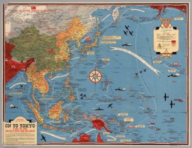
1944 Dated Events. On To Tokyo. Map of the Pa … Separate Map Dated Events. On To Tokyo. Map of the Pa … |

1811 Asia. World Atlas Asia, According to the best Authorities. … |

1851 Asia. World Atlas No. XLV. Stieler's Hand-Atlas (No. 39). … |

1785 Mediterranean E. World Atlas (A map of the Mediterranean Sea with the … |

1808 Asia. World Atlas Asia. London, published by W. Faden, Geo … |

1808 NW America, NE Asia. World Atlas Chart of the N.W. coast of America and t … |

1822 Asia School Atlas Asia. (to accompany) The Juvenile Atlas … |

1851 27. Asien in physikalischer Beziehung Physical Atlas 27. Asien in physikalischer Beziehung. E … |

1907 The Far East - Central Commercial Chart. … Statistical Atlas The Far East - Central Commercial Chart. … |

1852 Mountains, Table Lands, Plains & Valleys … Physical Atlas The Mountains, Table Lands, Plains & Val … |

1808 Asia. World Atlas Asia. |

1808 Central Asia. World Atlas Central Asia. |

1817 Asia. World Atlas Asia. |

1785 N.W. coast America, N.E. coast Asia. Exploration Book Chart of the N.W. coast of America and N … |

1800 Asia. World Atlas Asia. |

1800 Asia. World Atlas Asia. |

1814 Terra Veteribus Nota. World Atlas Terra Veteribus Nota. |

1834 Asia. World Atlas No. XLV. Stieler's Hand-Atlas (No. 39). … |

1875 Indien & Inner-Asien, Nordliches Blatt. World Atlas Indien & Inner-Asien, Nordliches Blatt. … |

1875 Composite: Indien, Inner-Asien in 2 Blat … World Atlas (Composite of) Indien & Inner-Asien in 2 … |

1875 China (Ostl. Theil), Korea Und Japan. World Atlas China (Ostl. Theil), Korea Und Japan Im … |

1875 Ost-Indien. World Atlas Ost-Indien. Gezeichnet von F. v. Stulpna … |

1811 Asia. World Atlas Asia. London, Published by S.A. Oddy, No … |

1817 Covers: Map of Asia Minor Armenia and Ko … Case Map (Covers to) Map of Asia Minor Armenia an … |

1817 Map of Asia Minor Armenia and Koordistan Case Map Map of Asia Minor Armenia and Koordistan … |

1818 Covers: Asia, SE section only Case Map (Covers to) Asia, SE section only |

1818 Asia, SE section only Case Map Asia, SE section only |

1883 Asia. World Atlas Asia. |

1825 Asia. World Atlas Asia. American Atlas. Published by H.S. … |

1943 Target Tokyo. Separate Map Target Tokyo. Newsmap. Monday, October 1 … |

1856 142. Carte Physique et Politique de L'As … World Atlas 142. Carte Physique et Politique de L'As … |