Who What Where WhenREMOVEWHEREShow More |
Author
[Smyth, Newton V.V., Drury, R.L.]
Full Title
Map of The City Of Santa Rosa And Vicinity, Sonoma Co., Cal. Compiled From Maps Of Record, Private Maps And Actual Surveys, By Newton V.V. Smyth, City Engineer. Drawn by R.L. Drury. Copyright 1896 by Newton V.V. Smyth (inset) Map showing The Relative Position Of Santa Rosa To The Bay Of San Francisco and its Railroad Facilities. (with 2 additional inset maps).
Publisher
No Publisher
Author
[Ricksecker, L.E., Walkup, W.B.]
Full Title
Official Map of Sonoma County, California Compiled From The Official Maps In The County Assessor's Office, With Additions And Corrections To June 1st 1900 by L.E. Ricksecker, City Engineer Of Santa Rosa, Ex-County Surveyor, and W.B. Walkup, Publisher. Approved and declared to be the official map of Sonoma County, by resolution of the Board of Supervisors, September 7th 1900 ... Copyrighted Sept. 1900 By W.B. Walkup. (one sheet of four only, upper right sheet with title showing the northwestern portions of the county).
Publisher
W.B. Walkup
Author
[Britton & Co., Gensoul, A.]
Full Title
Railroad Map Of The City Of San Francisco California. Printed For The San Francisco Directory By Britton & Co. 1864. Lith. Britton & Co. S.F.
Publisher
Britton & Co.
Author
Stillman, G.K.
Full Title
The Mammoth Trees Of California. (Calaveras County.) (Sequoia Gigantea.) Presented to the Subscribers of the Cincinnati Weekly Times. Times Steam Job Color Press Print. G.K. Stillman, Engraver, 4th & Walnut, Cin.
Publisher
Cincinnati Weekly Times
Author
California Pacific Railroad
Full Title
Map Showing California Pacific Rail Road Extension And California Pacific Rail Road With Their Connections. 1869. Steam Litho. Britton & Rey, S.F.
Publisher
Britton & Rey
Author
California Development Board
Full Title
Geographical, Topographical, State Highway And Railroad Map Of California. Published By California Development Board 1914 ... Copyrighted 1914 California Development Board. Britton & Rey, Lithographers, Inc., S.F. (inset) Land area of California ...
Publisher
California Development Board
Author
New Richmond Land Company
Full Title
Map of Richmond, California. New Richmond Land Company, 801-803 Monadnock Building, San Francisco. Wall's Harbor Center Tract, The Value Center. Bolte & Braden Company, San Francisco.
Publisher
Bolte & Braden Company
Author
Retail Lumber Dealers' Association
Full Title
Map Showing Cartage Rates Per 1,000 Feet Or Less, Adopted By The Retail Lumber Dealers' Association. Copyrighted, 1894, by W.B. Walkup, Map Publisher, Map Work Of All Kinds, 530 Commercial St. San Francisco, California.
Publisher
W.B. Walkup
Author
California Public Works Commission
Full Title
Sutter Basin. Compiled from surveys made and data collected by the late State Engineer Department; from Public Land, Rail Road and private surveys. 1895. Commissioner Of Public Works, California. A.H. Rose, Commissioner. Marsden Manson, C.E. Grunsky, Consulting Engineers. J.C. Henkenius, Chief Draughtsman. Photo. Lith. Britton & Rey, S.F.
Publisher
Britton & Rey
Author
Spring Valley Water Works
Full Title
Map Of San Francisco Showing The Water Service Of Spring Valley Water Works. Distributing Reservoirs, Districts Supplied By Each And Location Of Principal Distributing Mains, Contour Lines, Showing Elevation Above Water & Fire Department And Fire Patrol Buildings. 1894. Photo. Lith. Britton & Rey, S.F.
Publisher
Britton & Rey
Author
U.S. War Department, Chief of Engineers
Full Title
Map Of California And Nevada, With Parts Of Utah & Arizona. Prepared in the Office of the Chief Of Engineers U.S.A. 1879.
Publisher
War Department
Author
Mitchell, Samuel Augustus
Full Title
A new map of the State of California, the Territories of Oregon & Utah, and the Chief part of New Mexico. Entered ... 1853, by Thomas, Cowperthwait & Co. ... Pennsylvania.
Publisher
Thomas, Cowperthwait & Co.
Author
Mitchell, Samuel Augustus Jr.
Full Title
County Map of the State of California. (inset) San Francisco Bay and Vicinity. San Francisco. Entered ... 1874 by S. Augustus Mitchell ... Washington.
Publisher
Ziegler & McCurdy
Author
Tanner, Henry S.
Full Title
(Covers to) A Map Of The United States Of Mexico, As organized and defined by the several Acts of the Congress of that Republic. Constructed from a great variety of Printed and Manuscript Documents by H.S. Tanner. Third Edition, 1846. Published by H.S. Tanner. Entered ... 1846, by H.S. Tanner ... New York. (inset) Map Of The Roads &c. From Vera Cruz & Alvarado To Mexico.
Publisher
H.S. Tanner
Author
Gibbes, C.D.
Full Title
A New Map Of California. By Charles Drayton Gibbes From his own and other Recent Surveys and Explorations. MDCCCLII. Published by C.D. Gibbes, Stockton, Cal. Sherman & Smith, New York. Entered ... 1852 by Sherman & Smith ... New York. (inset) Map Of The United States Of America, Mexico, Central America, Cuba &c.
Publisher
C.D. Gibbes
Author
Gibbes, C.D.
Full Title
(Covers to) A New Map Of California. By Charles Drayton Gibbes From his own and other Recent Surveys and Explorations. MDCCCLII. Published by C.D. Gibbes, Stockton, Cal. Sherman & Smith, New York. Entered ... 1852 by Sherman & Smith ... New York. (inset) Map Of The United States Of America, Mexico, Central America, Cuba &c.
Publisher
C.D. Gibbes
Author
Johnson, A.J.
Full Title
Johnson's California, With Territories of Utah, Nevada, Colorado, New Mexico And Arizona,Published By Johnson and Ward. Entered ... 1864, by A.J. Johnson ... New York.
Publisher
Johnson and Ward
Author
Mitchell, Samuel Augustus
Full Title
A new map of the state of California, the territories of Oregon, Washington, Utah and New Mexico. Published by Thomas, Cowperthwait & Co., no. 253 Market Street, Philadelphia. Entered ... 1853 by Thomas, Cowperthwait & Co. ... Pennsylvania.
Publisher
Cowperthwait, Desilver & Butler
Author
[Johnstone, E. McD., Southern Pacific Company]
Full Title
Climatic map of California. Published by the Southern Pacific Company. 1888. Compiled by E. McD. Johnstone, S.P. Co. From map prepared under the direction of Brig. Gen. H.C. Wright, Chief of Eng'rs. U.S.A. Lith H.S. Crocker & Co. S.F. Cal. Entered ... 1887, by the Southern Pacific Company ... Washington....
Publisher
Southern Pacific Company
Author
[Reece, C. W., Tucker, E.]
Full Title
Map of the Pleasant Valley Tract at Oroville, Butte Co., Cal. ... Containing about 600 acres. For sale in subdivision by E. Tucker, Oroville. Surveyed by C.W. Reece, C.E. December, 1887. Lith. Dakin Pub. Co. S.F. Cal. (inset) Map showing relative location of Pleasant Valley Tract to City of Oroville, Cal.
Publisher
Dakin Pub. Co.
Author
[Reece, C. W., Tucker, E.]
Full Title
View of Pleasant Valley Tract and City of Oroville, Cal. Lith. Dakin Pub. Co., S.F., Cal. (folded title) The Pleasant Valley Tract in the Butte County citrus belt, one-half mile from Oroville, Cal. For sale by E. Tucker, Oroville, Cal. (1887)
Publisher
Dakin Pub. Co.
Author
U.S. Coast Survey
Full Title
U.S. Coast Survey A.D. Bache, Superintendent Reconnaissance Of The Western Coast Of The United States, Middle Sheet, From San Francisco To Umpquah River. By the Hydrographic Party under the command of Lieut. James Alden U.S.N. Assist. Geographical Positions by G. Davidson Assistant. 1854. Corrected to 1869. Drawn by W.B. McMurtrie; Reduction for engraving by A. Lindenkohl. Engd. by G. McCoy, J. Knight, J.L Hazzard & G.B. Metzeroth. No. 602. Electrotype Copy No. 6 by G. Mathiot U.S.C.S.
Publisher
U.S. Coast Survey
Author
McKay, Scott
Full Title
Official map of the county of Fresno, California. Compiled from official records and latest surveys by Scott McKay, C.E., County Surveyor, Fresno County. 1914. Britton & Rey, Lithographers Inc. Compliments of Scott McKay, Candidate for County Surveyor ... 3 Herald Job Print.
Publisher
Britton & Rey, Lithographers Inc.
Author
U.S. Coast Survey
Full Title
Tomales Bay California. From a Trigonometrical Survey under the direction of A.D. Bache Superintendent of the Survey Of The Coast Of The United States. Triangulation by G.A. Fairfield and G. Davidson Assts. Coast Survey. Topography by A.F. Rodgers Asst. and J.S. Lawson Sub-Asst. Hydrography by the Party under the command of J. Alden and B.F. Sands Comdrs. U.S.N. Asst. Coast Survey ... Issued in May 1878 C.P. Patterson Superintendent. Verified J.E. Hilgard ... (Tomales Bay) U.S.C. & G.S. No. 5618 Price 25 Cents. Plate No. 1152. Electrotype Copy No. 2 by G. Mathiot U.S.C.S.
Publisher
U.S. Coast Survey
Author
U.S. Coast Survey
Full Title
Bodega Bay, California. From a Trigonometrical Survey under the direction of A.D. Bache Superintendent of the Survey Of The Coast Of The United States. Triangulation by G.A. Fairfield and G. Davidson Assists. Topography by A.F. Rodgers Assist. Hydrography by the party under the command of Comdr. B.F. Sands U.S.N. Asst. (Polyconic Projection). (Date of first publication 1864). U.S. Coast Survey Office. Price 20 Cents. Verified J.E. Hilgard ... Redd. Drng. by F. Fairfax and W.B. McMurtrie. Edgd. by W.A. Thompson and E.H. Sipe. (Bodega Bay) U.S.C. & G.S. 5627.
Publisher
U.S. Coast Survey
Author
[Honey Lake Valley Land and Water Company, Taylor, L. H. (Leon Henry), b. 1863]
Full Title
Plate No.4 showing reservoir, canals and ditches : [Honey Lake Valley, Calif.] Honey Lake Valley Land and Water Company. Office: Room 6, Flood Building, San Francisco, Cal. L.H. Taylor, Engineer-in-Chief. (1891?)
Publisher
Honey Lake Valley Land & Water Company
Author
[Ferry, Hypolite, Marzolla, Benedetto]
Full Title
Nuova California, Stati Uniti dell'America Settentrionale. (with) Carta particolare delle Baie di Monterey e di Francisco disegnata secondo i lavori idrografici piu recenti. La presente Carta e stata eseguita su quella, pubblicata nel 1850 dal Signr. Ipolito Ferry ... Atlante Geografico di B. Marzolla. Napoli, 1851.
Publisher
B. Marzolla
Author
California: Office of State Engineer
Full Title
(State Engineer's Map of Northern California).
Publisher
California: Office of State Engineer
Author
California: Office of State Engineer
Full Title
(State Engineer's Map of Northern California).
Publisher
California: Office of State Engineer
Author
California: Office of State Engineer
Full Title
(State Engineer's Map of Northern California).
Publisher
California: Office of State Engineer
Author
California: Office of State Engineer
Full Title
(State Engineer's Map of Northern California).
Publisher
California: Office of State Engineer
Author
California: Office of State Engineer
Full Title
(State Engineer's Map of Northern California).
Publisher
California: Office of State Engineer
Author
California: Office of State Engineer
Full Title
(State Engineer's Map of Northern California).
Publisher
California: Office of State Engineer
Author
California: Office of State Engineer
Full Title
(State Engineer's Map of Northern California).
Publisher
California: Office of State Engineer
Author
California: Office of State Engineer
Full Title
(State Engineer's Map of Northern California).
Publisher
California: Office of State Engineer
Author
California: Office of State Engineer
Full Title
(State Engineer's Map of Northern California).
Publisher
California: Office of State Engineer
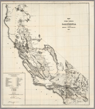
Author
U.S. General Land Office
Full Title
Map of the Public Surveys in California ; to Accompany Report of Surveyor Genl., 1854. P.S. Duval & Co's Steam Lith. Press. Phila. Surveyor General's Office, San Francisco, Calif., Sept. 28th, 1854, Approved John C. Hays, U.S. Sur. Genl. Cal.
Publisher
P.S. Duval
Author
U.S. General Land Office
Full Title
Map of the Public Surveys in California ; to Accompany Report of Surveyor Genl., 1855. Lith. by A. Hoen & Co. Balto. Surveyor General's Office, San Francisco, Calif., Sept. 30th, 1855, Approved John C. Hays, U.S. Sur. Genl. Cal.
Publisher
A. Hoen & Co.
Author
U.S. General Land Office
Full Title
Map of the Public Surveys in California ; to Accompany Report of Surveyor Genl., 1856. Surveyor General's Office, San Francisco, Calif., Sept. 30th, 1856, Approved, U.S. Sur. Genl. Cal.
Publisher
Surveyor General's Office
Author
U.S. General Land Office
Full Title
Map of the Public Surveys in California ; to Accompany Report of Surveyor Genl., 1857. Wagner & McGuigan Lith. Phila. Surveyor Generals' Office, San Francisco, California, September 30th, 1857, Approved J.W. Mandeville, U.S. Surr. Genl. Cala.
Publisher
Wagner & McGuigan
Author
U.S. General Land Office
Full Title
Map of the Public Surveys in California ; to Accompany Report of Surveyor Genl., 1858. Lith. by Siebert & Kogge, Washington Dist. Colba. Surveyor Generals' Office, San Francisco, California, September 18th, 1858. J.W. Mandeville, U.S. Surr. Genl. Cala.
Publisher
Siebert & Kogge
Author
U.S. General Land Office
Full Title
Map of the Public Surveys in California ; to Accompany Report of Surveyor Genl., 1859. Lith. of J. Bien, 180 Broadway, N.Y. Surveyor Generals' Office, San Francisco, California, September 19th, 1859. J.W. Mandeville, U.S. Surr. Genl. Cala.
Publisher
J. Bien
Author
U.S. General Land Office
Full Title
Map of the Public Surveys in California ; to Accompany Report of Surveyor Genl., 1860. Lith. of J. Bien, 180 Broadway, N.Y. Surveyor Generals' Office, San Francisco, California, September 15th, 1860. J.W. Mandeville, U.S. Surveyor General California.
Publisher
J. Bien
Author
U.S. General Land Office
Full Title
Map of the Public Surveys in California ; to Accompany Report of Surveyor Genl., 1861. Lith. of J. Bien, 180 Broadway, N.Y. Surveyor Generals' Office, San Francisco, California, September 15th, 1861. E.F. Beale, U.S. Survr. Genl. Cal.
Publisher
J. Bien
Author
U.S. General Land Office
Full Title
Map of the Public Surveys in California ; to Accompany Report of Surveyor Genl., 1862. Lith. of J. Bien, 180 Broadway, N.Y. Surveyor General's Office, San Francisco, California, September 15th, 1861. E.F. Beale, U.S. Survr. Genl. Cal.
Publisher
J. Bien
Author
U.S. General Land Office
Full Title
Map of public surveys in California & Nevada : to Accompany Report of Surveyor Genl., 1863. Lith. of J. Bien, N.Y. Surveyor General's Office, San Francisco, California, June 30th, 1863. E.F. Beale, U.S. Survr. Genl. Cal.
Publisher
J. Bien
Author
U.S. General Land Office
Full Title
Map of public surveys in California & Nevada : to Accompany Report of Surveyor Genl., 1863 (1864). Lith. of J. Bien, N.Y. Surveyor General's Office, San Francisco, California, June 30th, 1863. E.F. Beale, U.S. Survr. Genl. Cal.
Publisher
J. Bien
Author
Haven, John
Full Title
Map Of The United States And Mexico, Including Oregon, Texas And The Californias.
Publisher
No. publisher
Author
Ensigns & Thayer
Full Title
Ornamental Map Of The United States & Mexico. Map Of The United States And Mexico Including Oregon, Texas and the Californias. Entered ... 1848, by Ensigns & Thayer ... New York. Published by Ensign & Thayer, 50 Ann Street New York. And 12 Exchange St., Buffalo. Sowle & Ward, 43 Cornhill, Boston. Rufus Blanchard: Cincinatti.
Publisher
[Ensigns & Thayer ; Rufus Blanchard, Sowle & Ward]
|