Who What Where WhenREMOVEWHATShow More |
Author
Arrowsmith, Aaron
Full Title
United Kingdoms of Great Britain and Ireland. From Arrowsmith's map of the British Isles. Hooker sc. (Boston: Published by Thomas & Andrews. 1812)
Publisher
Thomas & Andrews
Author
Touring club italiano
Full Title
(Legend to) Belgio e Olanda, Belgique, Belgie, Nederland. Gran Bretagna, Great Britain. Propr. Artistico-letteraria del T.C.I. Ufficio cartografico del T.C.I. (1929)
Publisher
Touring club italiano
Author
Touring club italiano
Full Title
Gran Bretagna, Great Britain. Propr. Artistico-letteraria del T.C.I. Ufficio cartografico del T.C.I. (1929)
Publisher
Touring club italiano
Author
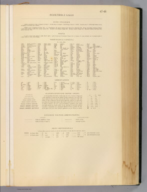
Touring club italiano
Full Title
(Legend to) Inghilterra e Galles, England and Wales. Propr. Artistico-letteraria del T.C.I. Ufficio cartografico del T.C.I. (1929)
Publisher
Touring club italiano
Author
Touring club italiano
Full Title
Inghilterra e Galles, England and Wales. Propr. Artistico-letteraria del T.C.I. Ufficio cartografico del T.C.I. (1929)
Publisher
Touring club italiano
Author
Patteson, Edward
Full Title
Insulae Britannicae. The British Isles. E.P. delint. S.I. Neele sculp, 352 Strand. Published June 15th 1804 by the Revd. E. Patteson, M.A., Richmond, Surrey.
Publisher
Patteson
Author
Patteson, Edward
Full Title
Insulae Britannicae. The British Isles. E.P. delin. Neele sc., 352 Strand. Published June 15th 1804 by the Revd. E. Patteson, M.A., Richmond, Surrey.
Publisher
Patteson
Author
Patteson, Edward
Full Title
England and Wales. E.P. delint. Mutlow, Sc., Russell Cot. (1804)
Publisher
Patteson
Author
Patteson, Edward
Full Title
England and Wales Roman and modern. E.P. compost. et delint. Mutlow, Sc., Russell Court. Published 15 June 1804, by the Revd. E. Patteson, Richmond, Surrey.
Publisher
Patteson
Author
Poussin, Guillaume Tell, 1794-1876
Full Title
Plan hydrographique de la partie de la Baie de la Delaware qui avoisine le breakwater ou port artificiel que l'on y a construit. (with) Plan general de la Baie de la Delaware et de la position occupee par le port artificiel construir a son embouchure. (with) Plan general de la Baie et du breakwater de Plymouth. (with) Plan general de la rade et de la Baie de Cherbourg. (with) Section transversale du breakwater ou jetee de Plymouth. (with) Section transversale de la Digue de Cherbourg et profil de l'enrochment de 1784. (with) Section transversale du breakwater ou jetee de la Delaware. Dessine par le Major Poussin. Grave par (V.?) Adam. (1834)
Publisher
[Libraire Anselin, Libraire Carilian-Goeury]
Author
[Morse, H., Worcester, J. E.]
Full Title
Britain of the United Kingdom of England, Scotland and Ireland. H. Morse Sc. Published by Cummings & Hilliard, No. 1 Cornhill, Boston. (ca. 1821)
Publisher
Cummings & Hilliard
Author
Goodrich, S.G.
Full Title
Pacific Ocean. British Islands. G. Boynton Sc. Entered ... by S.G. Goodrich of Massachusetts. (Boston: Gray & Bowen ... 1831)
Publisher
Gray & Bowen
Author
Cummings, J. A. (Jacob Abbot)
Full Title
Britain or the United Kingdom of England, Scotland and Ireland. Published by Cummings & Hilliard, No. 1, Cornhill, Boston. H. Morse Sc. (1821?)
Publisher
Cummings and Hilliard
Full Title
England & Wales. Philad. Published by M. Carey and Son, 1820.
Publisher
M. Carey & Son
Author
Horsley, John, 1675-1732
Full Title
Britannia Antiqua. Auctore Horsley. W. Sim, Sc. (1814?)
Publisher
R. M'Dermut
Author
Mitchell, Samuel Augustus
Full Title
Map of Great Britain and Ireland. Engraved to illustrate Mitchell's school and family geography. J.H. Young Sc. Entered ... 1840 by S. Augustus Mitchell ... Eastern District of Pennsylvania.
Publisher
Thomas, Cowperthwait & Co.
Author
Mitchell, Samuel Augustus
Full Title
County map of England, and Wales. Entered ... 1879 by S. Augustus Mitchell ... Washington. (1880)
Publisher
S.A. Mitchell
Full Title
County map of England, and Wales. Copyright 1887 by Wm. M. Bradley & Bro. (1890)
Publisher
John Y. Huber & Co.
Full Title
British Isles. (with) The Channel Islands. (with) The Shetland Islands. (Published at the office of "The Times," London, 1895)
Publisher
The Times
Full Title
England and Wales, north. (Published at the office of "The Times," London, 1895)
Publisher
The Times
Full Title
England and Wales, south. (Published at the office of "The Times," London, 1895)
Publisher
The Times
Author
[Bartholomew, J. G. (John George), 1860-1920, John Bartholomew & Co.]
Full Title
British Isles -- bathy-orographical. The Edinburgh Geographical Institute, John Bartholomew & Co. "The Times" atlas. (London: The Times, 1922)
Publisher
The Times
Author
[Bartholomew, J. G. (John George), 1860-1920, John Bartholomew & Co.]
Full Title
British Isles - vegetation & climate. The Edinburgh Geographical Institute, John Bartholomew & Co. "The Times" atlas. (London: The Times, 1922)
Publisher
The Times
Full Title
Grossbritannien und Irland. (with) Die Canal Inseln. (with) Die Shetland Inseln. (Richard Andree. Herausgegeben von der Geographischen Anstalt von Velhagen & Klasing in Leipzig. 1881)
Publisher
Velhagen & Klasing
Author
Moll, Herman, d. 1732
Full Title
A general map of Great Britain and Ireland, with part of Germany, Holland, Flanders, France &c. Agreeable to modern history. By H. Moll Geographer. (with Farro, Schetland and Orkney islands). (Printed for Tho: Bowles next ye Chapter House in St. Pauls Church Yard, & John Bowles at the Black Horse in Cornhill, London 1736?)
Publisher
Thos. Bowles and John Bowles
Full Title
British Islands. N. & S.S. Jocelyn Sc. (Boston: Published by Richardson & Lord. 1820)
Publisher
Richardson & Lord
Author
Greenleaf, Jeremiah
Full Title
British Islands.
Publisher
G.R. French
Author
Seaman, James V.
Full Title
England and Wales. Published by J.V. Seaman, 296 Pearl St., N. York. (1821)
Publisher
James V. Seaman
Author
Clouet, J. B. L. (Jean-Baptiste Louis), b. 1730
Full Title
Des Isles Britanniques. (1787)
Publisher
Mondhare et Jean
Full Title
England and Wales. (By Frances Bowen. 1810)
Publisher
Manuscript
Full Title
British Isles. (with) Shetland Isles. (Boston: Hilliard, Gray, Little and Wilkins, 1826)
Publisher
Hilliard, Gray, Little and Wilkins
Author
Mitchell, Samuel Augustus
Full Title
County map of England and Wales. Entered ... 1870 by S. Augustus Mitchell, Jr. ... Pennsylvania.
Publisher
[R.A. Campbell, S.A. Mitchell, Jr.]
Full Title
Die Brittischen Inseln. England, Schottland, Ireland. (Efter Stielers Hand-Atlas. Stockholm, J.L. Brudin, 1852)
Publisher
J.L. Brudin
Full Title
(La Grande-Bretagne. A Lyon, Chez Jean-Marie Bruyset, Pere & Fils. M.DCC.LXXXIV)
Publisher
Jean-Marie Bruyset
Author
Fenner, Rest.
Full Title
Britannicae Insulae. Fenner Sc., Paternoster Row. (London, Joseph Thomas, 1835)
Publisher
Joseph Thomas
Author
Fenner, Rest.
Full Title
British Isles. Fenner Sc., Paternoster Row. (London, Joseph Thomas, 1835)
Publisher
Joseph Thomas
Author
[Stieler, Adolf, Stulpnagel, F.v.]
Full Title
(Composite of) No. XVII, XIX, XX. Stieler's Hand-Atlas (No. 15b, 15c, 15d.) England und Wales, Schotland, Ireland.
Publisher
Justus Perthes
Author
[Stieler, Adolf, Stulpnagel, F.v.]
Full Title
No. XVII. Stieler's Hand-Atlas (No. 15a.) Die Brittischen Inseln und Die Nord-See.
Publisher
Justus Perthes
Author
[Stieler, Adolf, Stulpnagel, F.v.]
Full Title
No. XVIII. Stieler's Hand-Atlas (No. 15b.) England und Wales.
Publisher
Justus Perthes
Author
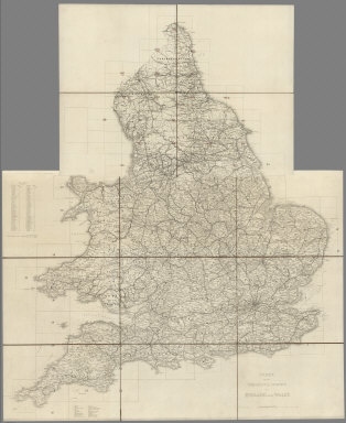
[Great Britain. Ordnance Survey, Mudge, William (1762-1820), Colby, Thomas, Baker, Benjamin, Great Britain. Board of Ordnance]
Full Title
(Index Map) Index to the Ordnance Survey of England and Wales.
Publisher
[W. Mudge; Ordnance Survey, Thomas Colby (1784-1852)]
Author
[Great Britain. Ordnance Survey, Mudge, William (1762-1820), Colby, Thomas, Baker, Benjamin, Great Britain. Board of Ordnance]
Full Title
(Index Map) Index to the Ordnance Survey of England and Wales, Published in Sheets on a Scale of one inch to a Mile.
Publisher
[W. Mudge; Ordnance Survey, Thomas Colby (1784-1852)]
Author
[Great Britain. Ordnance Survey, Mudge, William (1762-1820), Colby, Thomas, Baker, Benjamin, Great Britain. Board of Ordnance]
Full Title
1. Brentwood.
Publisher
[W. Mudge; Ordnance Survey, Thomas Colby (1784-1852)]
Author
[Great Britain. Ordnance Survey, Mudge, William (1762-1820), Colby, Thomas, Baker, Benjamin, Great Britain. Board of Ordnance]
Full Title
2. Sheerness.
Publisher
[W. Mudge; Ordnance Survey, Thomas Colby (1784-1852)]
Author
[Great Britain. Ordnance Survey, Mudge, William (1762-1820), Colby, Thomas, Baker, Benjamin, Great Britain. Board of Ordnance]
Full Title
3. Canterbury.
Publisher
[W. Mudge; Ordnance Survey, Thomas Colby (1784-1852)]
Author
[Great Britain. Ordnance Survey, Mudge, William (1762-1820), Colby, Thomas, Baker, Benjamin, Great Britain. Board of Ordnance]
Full Title
4. Denge Ness.
Publisher
[W. Mudge; Ordnance Survey, Thomas Colby (1784-1852)]
Author
[Great Britain. Ordnance Survey, Mudge, William (1762-1820), Colby, Thomas, Baker, Benjamin, Great Britain. Board of Ordnance]
Full Title
5. Hastings.
Publisher
[W. Mudge; Ordnance Survey, Thomas Colby (1784-1852)]
Author
[Great Britain. Ordnance Survey, Mudge, William (1762-1820), Colby, Thomas, Baker, Benjamin, Great Britain. Board of Ordnance]
Full Title
6. Maidstone.
Publisher
[W. Mudge; Ordnance Survey, Thomas Colby (1784-1852)]
Author
[Great Britain. Ordnance Survey, Mudge, William (1762-1820), Colby, Thomas, Baker, Benjamin, Great Britain. Board of Ordnance]
Full Title
7. London.
Publisher
[W. Mudge; Ordnance Survey, Thomas Colby (1784-1852)]
Author
[Great Britain. Ordnance Survey, Mudge, William (1762-1820), Colby, Thomas, Baker, Benjamin, Great Britain. Board of Ordnance]
Full Title
8. Dorking.
Publisher
[W. Mudge; Ordnance Survey, Thomas Colby (1784-1852)]
|