Who What Where WhenREMOVEWHATShow More |
Author
Lizars, Daniel
Full Title
Southern part of England. Published by D. Lizars, Edinburgh. (1831?)
Publisher
[John Hamilton, W. Curry, Jun. & Co., Whittaker, Treacher & Co.]
Author
Lizars, Daniel
Full Title
(Composite of) England. Published by D. Lizars, Edinburgh. (1831?)
Publisher
[John Hamilton, W. Curry, Jun. & Co., Whittaker, Treacher & Co.]
Author
Letts, Son & Co.
Full Title
Railway & statistical map of England & Wales. Letts's popular atlas. (with) Enlarged map of the district of Liverpool & Manchester. Letts, Son & Co. Limited, London. (1883)
Publisher
Letts, Son & Co.
Author
[Bristow, Henry W., Letts, Son & Co.]
Full Title
Geological map of England & Wales, with leading railways by Henry W. Bristow, F.R.S., F.G.S., Director of the Geological Survey of England and Wales. Letts's popular atlas. Letts, Son & Co. Limited, London. (1883)
Publisher
Letts, Son & Co.
Author
Letts, Son & Co.
Full Title
Watershed map of England & Wales. No. 1. Letts's popular atlas. Letts, Son & Co. Limited, London. (1883)
Publisher
Letts, Son & Co.
Author
Letts, Son & Co.
Full Title
Watershed map of England & Wales. No. 2. Letts's popular atlas. Letts, Son & Co. Limited, London. (1883)
Publisher
Letts, Son & Co.
Author
Letts, Son & Co.
Full Title
Watershed map of England & Wales. No. 3. Letts's popular atlas. Letts, Son & Co. Limited, London. (1883)
Publisher
Letts, Son & Co.
Author
Letts, Son & Co.
Full Title
Watershed map of England & Wales. No. 4. Letts's popular atlas. Letts, Son & Co. Limited, London. (1883)
Publisher
Letts, Son & Co.
Author
Letts, Son & Co.
Full Title
Watershed map of England & Wales. No. 5. Letts's popular atlas. Letts, Son & Co. Limited, London. (1883)
Publisher
Letts, Son & Co.
Author
Letts, Son & Co.
Full Title
Watershed map of England & Wales. No. 6. Letts's popular atlas. Letts, Son & Co. Limited, London. (1883)
Publisher
Letts, Son & Co.
Author
[Kitchin, Thomas, Phillips, J., Robert Laurie & James Whittle]
Full Title
A new map of England & Wales. (North half). Drawn from several surveys &c. on the new projection : corrected from astronomical observations & the places marked where the observatns. were made. By Thos. Kitchin, Geogr. The canals inserted to 1792 by J. Phillips, Surveyor. London, Published by Laurie & Whittle, No. 53, Fleet Street, as the act directs, 12th May, 1794.
Publisher
Laurie & Whittle
Full Title
(A new map of England & Wales. (South half). Drawn from several surveys &c. on the new projection : corrected from astronomical observations & the places marked where the observatns. were made. By Thos. Kitchin, Geogr. The canals inserted to 1792 by J. Phillips, Surveyor. London, Published by Laurie & Whittle, No. 53, Fleet Street, as the act directs, 12th May, 1794)
Publisher
Laurie & Whittle
Author
[Kitchin, Thomas, Phillips, J., Robert Laurie & James Whittle]
Full Title
(Composite of) A new map of England & Wales. Drawn from several surveys &c. on the new projection : corrected from astronomical observations & the places marked where the observatns. were made. By Thos. Kitchin, Geogr. The canals inserted to 1792 by J. Phillips, Surveyor. London, Published by Laurie & Whittle, No. 53, Fleet Street, as the act directs, 12th May, 1794.
Publisher
Laurie & Whittle
Full Title
England and Wales. From the various surveys of England. (Benjamin?) Jones sc. (Published by John Conrad & Co., Philadelphia. 1804)
Publisher
J. Conrad
Author
Touring club italiano
Full Title
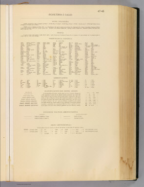
(Legend to) Inghilterra e Galles, England and Wales. Propr. Artistico-letteraria del T.C.I. Ufficio cartografico del T.C.I. (1929)
Publisher
Touring club italiano
Author
Touring club italiano
Full Title
Inghilterra e Galles, England and Wales. Propr. Artistico-letteraria del T.C.I. Ufficio cartografico del T.C.I. (1929)
Publisher
Touring club italiano
Author
Patteson, Edward
Full Title
England and Wales. E.P. delint. Mutlow, Sc., Russell Cot. (1804)
Publisher
Patteson
Author
Patteson, Edward
Full Title
England and Wales Roman and modern. E.P. compost. et delint. Mutlow, Sc., Russell Court. Published 15 June 1804, by the Revd. E. Patteson, Richmond, Surrey.
Publisher
Patteson
Full Title
England & Wales. Philad. Published by M. Carey and Son, 1820.
Publisher
M. Carey & Son
Author
Mitchell, Samuel Augustus
Full Title
County map of England, and Wales. Entered ... 1879 by S. Augustus Mitchell ... Washington. (1880)
Publisher
S.A. Mitchell
Full Title
County map of England, and Wales. Copyright 1887 by Wm. M. Bradley & Bro. (1890)
Publisher
John Y. Huber & Co.
Full Title
England and Wales, north. (Published at the office of "The Times," London, 1895)
Publisher
The Times
Full Title
England and Wales, south. (Published at the office of "The Times," London, 1895)
Publisher
The Times
Author
Seaman, James V.
Full Title
England and Wales. Published by J.V. Seaman, 296 Pearl St., N. York. (1821)
Publisher
James V. Seaman
Full Title
England and Wales. (By Frances Bowen. 1810)
Publisher
Manuscript
Author
Mitchell, Samuel Augustus
Full Title
County map of England and Wales. Entered ... 1870 by S. Augustus Mitchell, Jr. ... Pennsylvania.
Publisher
[R.A. Campbell, S.A. Mitchell, Jr.]
Author
[Stieler, Adolf, Stulpnagel, F.v.]
Full Title
(Composite of) No. XVII, XIX, XX. Stieler's Hand-Atlas (No. 15b, 15c, 15d.) England und Wales, Schotland, Ireland.
Publisher
Justus Perthes
Author
[Stieler, Adolf, Stulpnagel, F.v.]
Full Title
No. XVII. Stieler's Hand-Atlas (No. 15a.) Die Brittischen Inseln und Die Nord-See.
Publisher
Justus Perthes
Author
[Stieler, Adolf, Stulpnagel, F.v.]
Full Title
No. XVIII. Stieler's Hand-Atlas (No. 15b.) England und Wales.
Publisher
Justus Perthes
Author
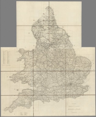
[Great Britain. Ordnance Survey, Mudge, William (1762-1820), Colby, Thomas, Baker, Benjamin, Great Britain. Board of Ordnance]
Full Title
(Index Map) Index to the Ordnance Survey of England and Wales.
Publisher
[W. Mudge; Ordnance Survey, Thomas Colby (1784-1852)]
Author
[Great Britain. Ordnance Survey, Mudge, William (1762-1820), Colby, Thomas, Baker, Benjamin, Great Britain. Board of Ordnance]
Full Title
(Index Map) Index to the Ordnance Survey of England and Wales, Published in Sheets on a Scale of one inch to a Mile.
Publisher
[W. Mudge; Ordnance Survey, Thomas Colby (1784-1852)]
Author
[Great Britain. Ordnance Survey, Mudge, William (1762-1820), Colby, Thomas, Baker, Benjamin, Great Britain. Board of Ordnance]
Full Title
1. Brentwood.
Publisher
[W. Mudge; Ordnance Survey, Thomas Colby (1784-1852)]
Author
[Great Britain. Ordnance Survey, Mudge, William (1762-1820), Colby, Thomas, Baker, Benjamin, Great Britain. Board of Ordnance]
Full Title
2. Sheerness.
Publisher
[W. Mudge; Ordnance Survey, Thomas Colby (1784-1852)]
Author
[Great Britain. Ordnance Survey, Mudge, William (1762-1820), Colby, Thomas, Baker, Benjamin, Great Britain. Board of Ordnance]
Full Title
3. Canterbury.
Publisher
[W. Mudge; Ordnance Survey, Thomas Colby (1784-1852)]
Author
[Great Britain. Ordnance Survey, Mudge, William (1762-1820), Colby, Thomas, Baker, Benjamin, Great Britain. Board of Ordnance]
Full Title
4. Denge Ness.
Publisher
[W. Mudge; Ordnance Survey, Thomas Colby (1784-1852)]
Author
[Great Britain. Ordnance Survey, Mudge, William (1762-1820), Colby, Thomas, Baker, Benjamin, Great Britain. Board of Ordnance]
Full Title
5. Hastings.
Publisher
[W. Mudge; Ordnance Survey, Thomas Colby (1784-1852)]
Author
[Great Britain. Ordnance Survey, Mudge, William (1762-1820), Colby, Thomas, Baker, Benjamin, Great Britain. Board of Ordnance]
Full Title
6. Maidstone.
Publisher
[W. Mudge; Ordnance Survey, Thomas Colby (1784-1852)]
Author
[Great Britain. Ordnance Survey, Mudge, William (1762-1820), Colby, Thomas, Baker, Benjamin, Great Britain. Board of Ordnance]
Full Title
7. London.
Publisher
[W. Mudge; Ordnance Survey, Thomas Colby (1784-1852)]
Author
[Great Britain. Ordnance Survey, Mudge, William (1762-1820), Colby, Thomas, Baker, Benjamin, Great Britain. Board of Ordnance]
Full Title
8. Dorking.
Publisher
[W. Mudge; Ordnance Survey, Thomas Colby (1784-1852)]
Author
[Great Britain. Ordnance Survey, Mudge, William (1762-1820), Colby, Thomas, Baker, Benjamin, Great Britain. Board of Ordnance]
Full Title
9. Brighton.
Publisher
[W. Mudge; Ordnance Survey, Thomas Colby (1784-1852)]
Author
[Great Britain. Ordnance Survey, Mudge, William (1762-1820), Colby, Thomas, Baker, Benjamin, Great Britain. Board of Ordnance]
Full Title
10. Isle of Wight.
Publisher
[W. Mudge; Ordnance Survey, Thomas Colby (1784-1852)]
Author
[Great Britain. Ordnance Survey, Mudge, William (1762-1820), Colby, Thomas, Baker, Benjamin, Great Britain. Board of Ordnance]
Full Title
11. Winchester.
Publisher
[W. Mudge; Ordnance Survey, Thomas Colby (1784-1852)]
Author
[Great Britain. Ordnance Survey, Mudge, William (1762-1820), Colby, Thomas, Baker, Benjamin, Great Britain. Board of Ordnance]
Full Title
12. Basingstoke.
Publisher
[W. Mudge; Ordnance Survey, Thomas Colby (1784-1852)]
Author
[Great Britain. Ordnance Survey, Mudge, William (1762-1820), Colby, Thomas, Baker, Benjamin, Great Britain. Board of Ordnance]
Full Title
13. Oxford.
Publisher
[W. Mudge; Ordnance Survey, Thomas Colby (1784-1852)]
Author
[Great Britain. Ordnance Survey, Mudge, William (1762-1820), Colby, Thomas, Baker, Benjamin, Great Britain. Board of Ordnance]
Full Title
14. Devizes.
Publisher
[W. Mudge; Ordnance Survey, Thomas Colby (1784-1852)]
Author
[Great Britain. Ordnance Survey, Mudge, William (1762-1820), Colby, Thomas, Baker, Benjamin, Great Britain. Board of Ordnance]
Full Title
15. Salisbury.
Publisher
[W. Mudge; Ordnance Survey, Thomas Colby (1784-1852)]
Author
[Great Britain. Ordnance Survey, Mudge, William (1762-1820), Colby, Thomas, Baker, Benjamin, Great Britain. Board of Ordnance]
Full Title
16. Poole.
Publisher
[W. Mudge; Ordnance Survey, Thomas Colby (1784-1852)]
Author
[Great Britain. Ordnance Survey, Mudge, William (1762-1820), Colby, Thomas, Baker, Benjamin, Great Britain. Board of Ordnance]
Full Title
17. Dorchester.
Publisher
[W. Mudge; Ordnance Survey, Thomas Colby (1784-1852)]
Author
[Great Britain. Ordnance Survey, Mudge, William (1762-1820), Colby, Thomas, Baker, Benjamin, Great Britain. Board of Ordnance]
Full Title
18. Sherborne.
Publisher
[W. Mudge; Ordnance Survey, Thomas Colby (1784-1852)]
|