Who What Where WhenREMOVE |
Author
[Dower, John Nicaragua, Teesdale, Henry]
Full Title
A New Chart of the World On Mercator's Projection With The Tracks Of The Most Celebrated & Recent Navigators. Engraved by John Dower, Pentonville. Published By Henry Teesdale & Co. 2, Brunswick Row, Queens Square, London 1844.
Publisher
Henry Teesdale & Co.
Author
[Dower, John Nicaragua, Teesdale, Henry]
Full Title
(Covers to) A New Chart of the World On Mercator's Projection With The Tracks Of The Most Celebrated & Recent Navigators. Engraved by John Dower, Pentonville. Published By Henry Teesdale & Co. 2, Brunswick Row, Queens Square, London 1844.
Publisher
Henry Teesdale & Co.
Author
Rutley, F.
Full Title
Andrews' Schoolroom Chart Of Geographical Illustrations. Thomas Murby, 32, Bouverie Street, Fleet Street, London. Designed by F. Rutley Esq, H.M. Geol. Survey. Drawn by Waldo Sargeant, Printed by W. Griggs. (inset) Map Of Europe Explanatory Of Geographical Terms. (untitled birds eye view illustrating land and water formations). (with 6 additional inset maps and 1 profile).
Publisher
Thomas Murby
Author
Townsend, Dennis
Full Title
(Covers to) Townsend's Patent Folding Globe ... Publishers: George M. Smith & Co., 129 Washington Street, Boston, Mass. Dennis Townsend, Felchville, Windsor County Vt. Edward E. Rice & Co., Steam Job Printers, 5 Hawley Street, Boston, Mass. (On the cover of the folder holding the collapsed globe; on the globe itself: "Patented by Dennis Townsend Feb. 16, 1869").
Publisher
[Dennis Townsend, George M. Smith]
Author
Melish, John
Full Title
(Covers to) Melish's Universal School Atlas. Philadelphia, Published 1816. Improved to 1820. S. Harrison, Sc.
Publisher
John Melish
Author
Melish, John
Full Title
(Title Page to) Melish's Universal School Atlas. Philadelphia, Published 1816. Improved to 1820. S. Harrison, Sc.
Publisher
John Melish
Author
Melish, John
Full Title
Map of the World from the latest discoveries. No. II. Saml. Harrison sct. Published 1st Sepr. 1816 by J. Melish, Philadelphia. Improved to 1820.
Publisher
John Melish
Author
Melish, John
Full Title
The World on Mercator's Projection; with all the latest Discoveries. H.S. Tanner sc. Published 1st June 1816 by J. Melish, Philadelphia. Improved to 1820.
Publisher
John Melish
Author
Mitchell, Samuel Augustus
Full Title
(Covers to) Mitchell's School Atlas. Philadelphia: Thomas, Cowperthwait & Company. MDCCCXXXIX. Entered ... 1839, by S. Augustus Mitchell ... Connecticut.
Publisher
Thomas, Cowperthwait & Co.
Author
Mitchell, Samuel Augustus
Full Title
The World on an Equatorial Projection. No. 1. Map of the Eastern & Western Hemispheres. (with) The World on a Polar Projection. No 2. Map of the Northern & Southern Hemispheres. Engraved by J.H. Young. Entered ... 1839, by S. Augustus Mitchell ... Connecticut.
Publisher
Thomas, Cowperthwait & Co.
Author
Smiley, Thomas T.
Full Title
(Covers to) Smiley's Atlas, For The Use Of Schools And Families. A New Atlas, Intended To Illustrate The Encyclopedia Of Geography. (On The Plan Of Murray's Encyclopedia Of Geography.) ... Exhibiting The Natural And Political Divisions Of The Different Countries On The Globe. By Thos. T. Smiley, A.M., M.D. Philadelphia. Hogan & Thompson. (1842?), 1839 ... Entered ... 1838, by Thos. T. Smiley ... Pennsylvania.
Publisher
Hogan & Thompson
Author
Smiley, Thomas T.
Full Title
Atlantic Ocean.
Publisher
Hogan & Thompson
Author
Smiley, Thomas T.
Full Title
World Globular Projection.
Publisher
Hogan & Thompson
Author
Mitchell, Samuel Augustus
Full Title
(Covers to) Mitchell's Atlas Of Outline Maps, Intended To Be Filled Up By Pupils Studying Mitchell's School Geography And Atlas ... Philadelphia: Thomas, Cowperthwait, And Company. MDCCCXXXIX. Entered ... 1839, by S. Augustus Mitchell ... Pennsylvania.
Publisher
Thomas, Cowperthwait & Co.
Author
Anonymous
Full Title
(Covers to) Drawing Teacher. Geography.
Publisher
No Publisher
Author
Anonymous
Full Title
The United States; North America; South America; Europe; Africa; Asia.
Publisher
No Publisher
Author
[Fremin, A.R., Gaultier, J., Logerot]
Full Title
(Covers to) Atlas Geographique.
Publisher
Mon. Logerot
Author
[Fremin, A.R., Gaultier, J., Logerot]
Full Title
Amerique du Nord; Amerique du Sud; Oceanie; Afrique; Asie; Europe et ses Chemins de fer; France et ses Chemins de fer.
Publisher
Mon. Logerot
Author
Global Map Company
Full Title
(Covers to) The Global Map. Pat. No. D136173, Other Patents Pending. The Global Map Co. Minneapolis, Minn. Copyright By The H.M. Gousha Company, Chicago, Ill. Lithographed In U.S.A.
Publisher
The Global Map Company
Author
Global Map Company
Full Title
The Global Map. Pat. No. D136173, Other Patents Pending. The Global Map Co. Minneapolis, Minn.
Publisher
The Global Map Company
Author
Global Map Company
Full Title
(Verso of) The Global Map. Pat. No. D136173, Other Patents Pending. The Global Map Co. Minneapolis, Minn.
Publisher
The Global Map Company
Author
Tanner, Henry S.
Full Title
(Covers to) A New American Atlas Containing Maps Of The Several States of the North American Union, Projected and drawn on a Uniform Scale from Documents found in the public Offices of the United States and State Governments, and other Original and Authentic Information, By Henry S. Tanner ... Philadelphia: Published By H.S. Tanner. 1823. (title page only) Writing Drawn and Engraved by Joseph Perkins. Barralet del. Humphrys sc.
Publisher
Henry Tanner
Author
Tanner, Henry S.
Full Title
(Half Title Page to) A New American Atlas Containing Maps Of The Several States of the North American Union, Projected and drawn on a Uniform Scale from Documents found in the public Offices of the United States and State Governments, and other Original and Authentic Information, By Henry S. Tanner ... Philadelphia: Published By H.S. Tanner. 1823. (title page only) Writing Drawn and Engraved by Joseph Perkins. Barralet del. Humphrys sc.
Publisher
Henry Tanner
Author
Tanner, Henry S.
Full Title
(Title Page to) A New American Atlas Containing Maps Of The Several States of the North American Union, Projected and drawn on a Uniform Scale from Documents found in the public Offices of the United States and State Governments, and other Original and Authentic Information, By Henry S. Tanner ... Philadelphia: Published By H.S. Tanner. 1823. (title page only) Writing Drawn and Engraved by Joseph Perkins. Barralet del. Humphrys sc.
Publisher
Henry Tanner
Author
Tanner, Henry S.
Full Title
(Index Page to) A New American Atlas Containing Maps Of The Several States of the North American Union, Projected and drawn on a Uniform Scale from Documents found in the public Offices of the United States and State Governments, and other Original and Authentic Information, By Henry S. Tanner ... Philadelphia: Published By H.S. Tanner. 1823. (title page only) Writing Drawn and Engraved by Joseph Perkins. Barralet del. Humphrys sc.
Publisher
Henry Tanner
Author
Tanner, Henry S.
Full Title
(Geographical Memoir, pg. 1 in) A New American Atlas Containing Maps Of The Several States of the North American Union, Projected and drawn on a Uniform Scale from Documents found in the public Offices of the United States and State Governments, and other Original and Authentic Information, By Henry S. Tanner ... Philadelphia: Published By H.S. Tanner. 1823. (title page only) Writing Drawn and Engraved by Joseph Perkins. Barralet del. Humphrys sc.
Publisher
Henry Tanner
Author
Tanner, Henry S.
Full Title
(Geographical Memoir, pgs. 2-3 in) A New American Atlas Containing Maps Of The Several States of the North American Union, Projected and drawn on a Uniform Scale from Documents found in the public Offices of the United States and State Governments, and other Original and Authentic Information, By Henry S. Tanner ... Philadelphia: Published By H.S. Tanner. 1823. (title page only) Writing Drawn and Engraved by Joseph Perkins. Barralet del. Humphrys sc.
Publisher
Henry Tanner
Author
Tanner, Henry S.
Full Title
(Geographical Memoir, pgs. 4-5 in) A New American Atlas Containing Maps Of The Several States of the North American Union, Projected and drawn on a Uniform Scale from Documents found in the public Offices of the United States and State Governments, and other Original and Authentic Information, By Henry S. Tanner ... Philadelphia: Published By H.S. Tanner. 1823. (title page only) Writing Drawn and Engraved by Joseph Perkins. Barralet del. Humphrys sc.
Publisher
Henry Tanner
Author
Tanner, Henry S.
Full Title
(Geographical Memoir, pgs. 6-7 in) A New American Atlas Containing Maps Of The Several States of the North American Union, Projected and drawn on a Uniform Scale from Documents found in the public Offices of the United States and State Governments, and other Original and Authentic Information, By Henry S. Tanner ... Philadelphia: Published By H.S. Tanner. 1823. (title page only) Writing Drawn and Engraved by Joseph Perkins. Barralet del. Humphrys sc.
Publisher
Henry Tanner
Author
Tanner, Henry S.
Full Title
(Geographical Memoir, pgs. 8-9 in) A New American Atlas Containing Maps Of The Several States of the North American Union, Projected and drawn on a Uniform Scale from Documents found in the public Offices of the United States and State Governments, and other Original and Authentic Information, By Henry S. Tanner ... Philadelphia: Published By H.S. Tanner. 1823. (title page only) Writing Drawn and Engraved by Joseph Perkins. Barralet del. Humphrys sc.
Publisher
Henry Tanner
Author
Tanner, Henry S.
Full Title
(Geographical Memoir, pgs. 10-11 in) A New American Atlas Containing Maps Of The Several States of the North American Union, Projected and drawn on a Uniform Scale from Documents found in the public Offices of the United States and State Governments, and other Original and Authentic Information, By Henry S. Tanner ... Philadelphia: Published By H.S. Tanner. 1823. (title page only) Writing Drawn and Engraved by Joseph Perkins. Barralet del. Humphrys sc.
Publisher
Henry Tanner
Author
Tanner, Henry S.
Full Title
(Geographical Memoir, pgs. 12-13 in) A New American Atlas Containing Maps Of The Several States of the North American Union, Projected and drawn on a Uniform Scale from Documents found in the public Offices of the United States and State Governments, and other Original and Authentic Information, By Henry S. Tanner ... Philadelphia: Published By H.S. Tanner. 1823. (title page only) Writing Drawn and Engraved by Joseph Perkins. Barralet del. Humphrys sc.
Publisher
Henry Tanner
Author
Tanner, Henry S.
Full Title
(Geographical Memoir, pgs. 14-15 in) A New American Atlas Containing Maps Of The Several States of the North American Union, Projected and drawn on a Uniform Scale from Documents found in the public Offices of the United States and State Governments, and other Original and Authentic Information, By Henry S. Tanner ... Philadelphia: Published By H.S. Tanner. 1823. (title page only) Writing Drawn and Engraved by Joseph Perkins. Barralet del. Humphrys sc.
Publisher
Henry Tanner
Author
Tanner, Henry S.
Full Title
(Geographical Memoir, pgs. 16-17 in) A New American Atlas Containing Maps Of The Several States of the North American Union, Projected and drawn on a Uniform Scale from Documents found in the public Offices of the United States and State Governments, and other Original and Authentic Information, By Henry S. Tanner ... Philadelphia: Published By H.S. Tanner. 1823. (title page only) Writing Drawn and Engraved by Joseph Perkins. Barralet del. Humphrys sc.
Publisher
Henry Tanner
Author
Tanner, Henry S.
Full Title
(Geographical Memoir, pg. 18 in) A New American Atlas Containing Maps Of The Several States of the North American Union, Projected and drawn on a Uniform Scale from Documents found in the public Offices of the United States and State Governments, and other Original and Authentic Information, By Henry S. Tanner ... Philadelphia: Published By H.S. Tanner. 1823. (title page only) Writing Drawn and Engraved by Joseph Perkins. Barralet del. Humphrys sc.
Publisher
Henry Tanner
Author
Tanner, Henry S.
Full Title
(Text page in) A New American Atlas Containing Maps Of The Several States of the North American Union, Projected and drawn on a Uniform Scale from Documents found in the public Offices of the United States and State Governments, and other Original and Authentic Information, By Henry S. Tanner ... Philadelphia: Published By H.S. Tanner. 1823. (title page only) Writing Drawn and Engraved by Joseph Perkins. Barralet del. Humphrys sc.
Publisher
Henry Tanner
Author
Tanner, Henry S.
Full Title
The World on Mercators Projection. Engraved & Published by Tanner, Vallance, Kearney & Co. Philadelphia. American Atlas.
Publisher
Henry Tanner
Author
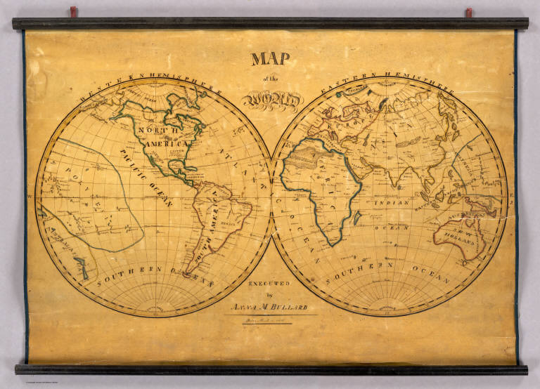
Bullard, Anna M.
Full Title
Map of the World. Executed by Anna M. Bullard. Boston March 15, 1836. Western Hemisphere. Eastern Hemisphere.
Publisher
Manuscript
Author
Berghaus, Heinrich
Full Title
(Covers to Vol. 1) Dr. Heinrich Berghaus' Physikalischer Atlas oder Sammlung von Karten, auf denen die hauptsachlichsten Erscheinungen der anorganischen und organischen Natur nach ihrer geographischen Verbreitung und Vertheilung bildlich dargestellt sind ... 1845. Verlag von Justus Perthes in Gotha ... 1848 ...
Publisher
Justus Perthes
Author
Berghaus, Heinrich
Full Title
(Title Page to Vol. 1) Dr. Heinrich Berghaus' Physikalischer Atlas oder Sammlung von Karten, auf denen die hauptsachlichsten Erscheinungen der anorganischen und organischen Natur nach ihrer geographischen Verbreitung und Vertheilung bildlich dargestellt sind ... 1845. Verlag von Justus Perthes in Gotha ... 1848 ...
Publisher
Justus Perthes
Author
Berghaus, Heinrich
Full Title
(Index Page to Vol. 1) Dr. Heinrich Berghaus' Physikalischer Atlas oder Sammlung von Karten, auf denen die hauptsachlichsten Erscheinungen der anorganischen und organischen Natur nach ihrer geographischen Verbreitung und Vertheilung bildlich dargestellt sind ... 1845. Verlag von Justus Perthes in Gotha ... 1848 ...
Publisher
Justus Perthes
Author
[Berghaus, Heinrich, Humboldt, Alexander von, 1769-1859]
Full Title
Alexander von Humboldt's System Der Isotherm-Kurven, in Merkator's Projection. 1ste. Abtheilung: Meteorologie No. 1. Gezeichnet v. Bar u. F. Schelle, nach Berghaus' Entwurf. Gestochen bei Madel II. Gotha, J. Perthes. 1838. Zweite Auflage. 1849.
Publisher
Justus Perthes
Author
Berghaus, Heinrich
Full Title
Die Isothermkurven Der Nordlichen Halbkugel. 1ste. Abtheilung: Meteorologie No. 2. Gezeichnet v. Bar, Berghaus, u. Schelle. In Potsdam Gestochen von K. Kolbe. Gotha, J. Perthes. 1838.
Publisher
Justus Perthes
Author
Berghaus, Heinrich
Full Title
Die Hauptmomente Der Temperatur Auf Dem Ganzen Erboden, gegrundet auf die Beobachtungen an 307 Orten. Thermometer-Centigrade. 1ste Abtheilung: Meteorologie No. 4.
Publisher
Justus Perthes
Author
Berghaus, Heinrich
Full Title
Graphische Darstellung des Ganges der Temperatur Innerhalb Der Tagl. Und Jahrl. Periode in Allen Zonen. 1ste. Abtheilung: Meteorologie No. 5. Potsdam, in der Geographischen Kunstschule. Gotha, bei Justus Perthes. 1839. Zweite Auflage. 1849.
Publisher
Justus Perthes
Author
Berghaus, Heinrich
Full Title
Ubersicht Der Mittleren Barometerstande Am Meere Und Der Oscillationen Des Luftdrucks. 1ste. Abtheilung: Meteorologie No. 6. Gest. v. W. Barns. Gotha, Justus Perthes. 1839.
Publisher
Justus Perthes
Author
Berghaus, Heinrich
Full Title
Windkarte der Erde. 1ste. Abtheilung: Meteorologie No. 7. Gezeichnet in der geographischen Kunstschule zu Potsdam. Gestochen von Edler. Gotha, Justus Perthes. 1840.
Publisher
Justus Perthes
Author
Berghaus, Heinrich
Full Title
Hyetographische Karte der Erde. 1ste. Abtheilung Meteorologie No. 9. Gez. u. gest. in der geogr. Kunstschule zu Potsdam. Gotha, bei J. Perthes. 1841.
Publisher
Justus Perthes
Author
Mitchell, Samuel Augustus
Full Title
(Index Page to) Mitchell's New General Atlas, Containing Maps Of The Various Countries Of The World, Plans Of Cities, Etc. Embraced In Forty-Seven Quarto Maps, Forming A Series Of Seventy-Six Maps And Plans, Together With Valuable Statistical Tables. Philadelphia: Published By S. Augustus Mitchell, Jr. No. 31 South Sixth Street. 1860. Entered ... 1860, by S. Augustus Mitchell, Jr. ... Pennsylvania.
Publisher
S.A. Mitchell, Jr.
Author
[La Martiniere, La Perouse, Jean-Francois de Galaup, comte de, 1741-1788]
Full Title
Insectes. Dessine par La Martiniere. Grave par PP. Choffard. L. Aubert scripsit. Atlas du Voyage de la Perouse, no. 20. (Paris: L'Imprimerie de la Republique, An V, 1797)
Publisher
L'Imprimerie de la Republique
|