Who What Where WhenREMOVEWHATShow MoreWHEREShow More |
Author
[Whitney, J.D., Watkins, C.E.]
Full Title
(View) The Half Dome.
Publisher
Julius Bien
Author
[Whitney, J.D., Watkins, C.E.]
Full Title
(View) View Up the Canyon of the Illilouette.
Publisher
Julius Bien
Author
[Whitney, J.D., Watkins, C.E.]
Full Title
(View) The Vernal Fall.
Publisher
Julius Bien
Author
[Whitney, J.D., Watkins, C.E.]
Full Title
(View) The Nevada Fall and the Cap of Liberty.
Publisher
Julius Bien
Author
[Whitney, J.D., Watkins, C.E.]
Full Title
(View) The Nevada Fall, near View.
Publisher
Julius Bien
Author
[Whitney, J.D., Watkins, C.E.]
Full Title
(View) Views from Sentinel Dome No. 1.
Publisher
Julius Bien
Author
[Whitney, J.D., Watkins, C.E.]
Full Title
(View) Views from Sentinel Dome No. 2.
Publisher
Julius Bien
Author
[Whitney, J.D., Watkins, C.E.]
Full Title
(View) Views from Sentinel Dome No. 3.
Publisher
Julius Bien
Author
[Whitney, J.D., Watkins, C.E.]
Full Title
(Composite) [Views from Sentinel Dome Nos. 1, 2, 3.; Photographs Nos. 19, 20, and 21.]
Publisher
Julius Bien
Author
[Whitney, J.D., Watkins, C.E.]
Full Title
(View) View Looking towards the Nevada and Merced Falls, from Glacier Point.
Publisher
Julius Bien
Author
[Whitney, J.D., Watkins, C.E.]
Full Title
(View) The Grizzly Giant, Mariposa Grove.
Publisher
Julius Bien
Author
[Whitney, J.D., Watkins, C.E.]
Full Title
(View) Base of the Grizzly Giant.
Publisher
Julius Bien
Author
[Whitney, J.D., Harris, W.]
Full Title
(View) Summit of Mt. Hoffmann.
Publisher
Julius Bien
Author
[Whitney, J.D., Harris, W.]
Full Title
(View) Lake Tenaya.
Publisher
Julius Bien
Author
[Whitney, J.D., Harris, W.]
Full Title
(View) Cathedral Peak, from Soda Springs.
Publisher
Julius Bien
Author
[Whitney, J.D., Harris, W.]
Full Title
(View) Valley of Mr. Lyell, Fork of the Upper Tuolumne.
Publisher
Julius Bien
Author
[Whitney, J.D., King, C., Gardner, J.T.]
Full Title
Map of the Yosemite Valley, from Surveys made by the order of the Commissioners to manage the Yosemite Valley and Mariposa Big Tree Grove, by C. King and J.T. Gardner 1865. Drawn by J.T.G. N.Y. Lithg. Engrg. & Prtg. Co. 16 & 18 Park Place.
Publisher
Julius Bien
Author
[Whitney, J.D., Gardner, J.T., Hoffmann, Chs. F.]
Full Title
Map of a Portion of the Sierra Nevada adjacent to Yosemite Valley, from surveys made by Chs. F. Hoffmann and J.T. Gardner, 1863, 1867. Geological Survey of Califoria, J.D. Whitney, State Geologist.
Publisher
Julius Bien
Author
[California Geological Survey, Whitney, J.D., Gardner, J.T., Hoffmann, Chs. F.]
Full Title
Map of a Portion of the Sierra Nevada adjacent to Yosemite Valley, from surveys made by Chs. F. Hoffmann and J.T. Gardner, 1863 -1867. Geological Survey of California, J.D. Whitney, State Geologist. J. Bien, Lith. N.Y.
Publisher
University Press
Author
[California Geological Survey, Whitney, J.D.]
Full Title
Map of the Routes from San Francisco to the Yosemite Valley. Prepared to accompany the pocket edition of the Yosemite Guide Book. (State Geol. Survey). 1871. J. Bien Photo Lith.
Publisher
University Press
Author
[California Geological Survey, Whitney, J.D.]
Full Title
Map of the Yosemite Valley, prepared to accompany the pocket edition of the Yosemite Guide Book. (State Geoogl. Survey). 1871. J. Bien Photo Lith.
Publisher
University Press
Author
[Bishop, F. M., De Motte, B. C., Geological and Geographical Survey of the Territories (U.S.), Powell, John Wesley, 1834-1902, Thompson, A. H. (Almon Harris), 1839-1906]
Full Title
Green River from the Union Pacific Rail Road to the mouth of White River, 1873 (land cover). Department of the Interior. U.S. Geological and Geographical Survey of the Territories. Second Division. J.W. Powell, geologist in charge, A.H. Thompson, geographer, B.C. De Motte & F.M. Bishop, topographers. W.H. Graves del. Outlines engraved by S.J. Kubel. U.S. G. and G. Survey, 2d. Div. ... Geology of the Unita Mountains. (Julius Bien Lith.)
Publisher
Julius Bien
Author
[Bishop, F. M., De Motte, B. C., Geological and Geographical Survey of the Territories (U.S.), Powell, John Wesley, 1834-1902, Thompson, A. H. (Almon Harris), 1839-1906]
Full Title
Green River from the Union Pacific Rail Road to the mouth of White River, 1873 (geology). Department of the Interior. U.S. Geological and Geographical Survey of the Territories. Second Division. J.W. Powell, geologist in charge, A.H. Thompson, geographer, B.C. De Motte & F.M. Bishop, topographers. W.H. Graves del. Outlines engraved by S.J. Kubel. U.S. G. and G. Survey, 2d. Div. ... Geology of the Unita Mountains. (Julius Bien Lith.)
Publisher
Julius Bien
Author
[Geological and Geographical Survey of the Territories (U.S.), Powell, John Wesley, 1834-1902]
Full Title
Structure sections through the Uinta Mountains. U.S. G. and G. Survey, 2d. Div., J.W. Powell, geologist in charge. Geology of the Unita Mountains. (Julius Bien Lith.)
Publisher
Julius Bien
Author
[Geological and Geographical Survey of the Territories (U.S.), Powell, John Wesley, 1834-1902]
Full Title
Displacement diagrams derived from the Structure sections through the Uinta Mountains, pl. I. U.S. G. and G. Survey, 2d. Div., J.W. Powell, geologist in charge. Geology of the Unita Mountains. (Julius Bien Lith.)
Publisher
Julius Bien
Author
[Geological and Geographical Survey of the Territories (U.S.), Powell, John Wesley, 1834-1902]
Full Title
Stereogram of the displacements of the eastern portion of the Uinta Mountains. U.S. G. and G. Survey, 2d. Div., J.W. Powell, geologist in charge. Geology of the Unita Mountains. (Julius Bien Lith.)
Publisher
Julius Bien
Author
[Geological and Geographical Survey of the Territories (U.S.), Gilbert, Grove Karl, 1843-1918, Powell, John Wesley, 1834-1902]
Full Title
Bird's-eye view of a part of the Uinta Uplift. Designed by G.K. Gilbert. U.S. G. and G. Survey, 2d. Div., J.W. Powell, geologist in charge. Geology of the Unita Mountains. (Julius Bien Lith.)
Publisher
Julius Bien
Author
[Geological and Geographical Survey of the Territories (U.S.), Powell, John Wesley, 1834-1902]
Full Title
Stereogram of the displacements of the Yampa Plateau. U.S. G. and G. Survey, 2d. Div., J.W. Powell, geologist in charge. Geology of the Unita Mountains. (Julius Bien Lith.)
Publisher
Julius Bien
Author
[Geological and Geographical Survey of the Territories (U.S.), Marvine, Archibald Robertson, 1848-1876, Powell, John Wesley, 1834-1902]
Full Title
No. 1. Structure section through the Aspen Mountain Uplift. No. 2. Displacement diagram derived from the above section. (with) Generalized structure section through the Park Mountains. By Archibald R. Marvine. U.S. G. and G. Survey, 2d. Div., J.W. Powell, geologist in charge. Geology of the Unita Mountains. (Julius Bien Lith.)
Publisher
Julius Bien
Author
[Geological and Geographical Survey of the Territories (U.S.), Powell, John Wesley, 1834-1902]
Full Title
(Covers to) Atlas accompanying the report on the geology of a portion of the Uinta Mountains and a region of country adjacent thereto by J.W. Powell, Geologist in charge 1876. Julius Bien Lith. Department of the Interior, U.S. Geographical and Geological Survey of the Territories, Second Division.
Publisher
Julius Bien
Author
[Geological and Geographical Survey of the Territories (U.S.), Powell, John Wesley, 1834-1902]
Full Title
(Title Page to) Atlas accompanying the report on the geology of a portion of the Uinta Mountains and a region of country adjacent thereto by J.W. Powell, Geologist in charge 1876. Julius Bien Lith. Department of the Interior, U.S. Geographical and Geological Survey of the Territories, Second Division.
Publisher
Julius Bien
Author
[Geographical and Geological Survey of the Rocky Mountain Region (U.S.), Jenney, Walter Proctor, 1849-1921, Newton, Henry, 1845-1877]
Full Title
Bird's eye view of the Black Hills to illustrate the geological structure. Dept. of the Interior, U.S.G. and G. Survey, J.W. Powell, in charge. Geology of the Black Hills by Henry Newton, E.M. (Julius Bien, Lith. New York, 1879)
Publisher
Julius Bien
Author
[Geographical and Geological Survey of the Rocky Mountain Region (U.S.), Jenney, Walter Proctor, 1849-1921, M'Gillycuddy, V. T., Mahlo, Emil, 1851-1904, Newton, Henry, 1845-1877, Tuttle, H. P.]
Full Title
Map of the Black Hills of Dakota, from explorations made in 1873. W.P. Jenney, Engineer of Mines, in charge. H. Newton, Engineer of Mines, geologist. V.T. M'Gillycuddy, M.D., topographer. H.P. Tuttle, A.M., astronomer. Drawn by Emil Mahlo. Dept. of the Interior, U.S.G. and G. Survey, J.W. Powell, in charge. Geology of the Black Hills by Henry Newton, E.M. (Julius Bien, Lith. New York, 1879)
Publisher
Julius Bien
Author
[Geographical and Geological Survey of the Rocky Mountain Region (U.S.), Newton, Henry, 1845-1877]
Full Title
Geological map of the Black Hills of Dakota by Henry Newton, E.M. Dept. of the Interior, U.S.G. and G. Survey, J.W. Powell, in charge. Geology of the Black Hills by Henry Newton, E.M. (Julius Bien, Lith. New York, 1879)
Publisher
Julius Bien
Author
[Geographical and Geological Survey of the Rocky Mountain Region (U.S.), Jenney, Walter Proctor, 1849-1921, Newton, Henry, 1845-1877]
Full Title
(covers to) Topographical and Geological Atlas of the Black Hills of Dakota to accompany the report of Henry Newton, E.M., assistant geologist. Department of the Interior, United States Geographical and Geological Survey of the Rocky Mountain Region, J.W. Powell, in charge. Julius Bien, Lith. New York, 1879.
Publisher
Julius Bien
Author
[Geographical and Geological Survey of the Rocky Mountain Region (U.S.), Jenney, Walter Proctor, 1849-1921, Newton, Henry, 1845-1877]
Full Title
(Title Page to) Topographical and Geological Atlas of the Black Hills of Dakota to accompany the report of Henry Newton, E.M., assistant geologist. Department of the Interior, United States Geographical and Geological Survey of the Rocky Mountain Region, J.W. Powell, in charge. Julius Bien, Lith. New York, 1879.
Publisher
Julius Bien
Author
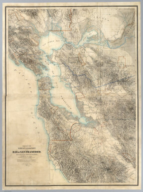
[Hoffmann, Charles F., Whitney, J.D., Geological Survey of California]
Full Title
Map Of The Region Adjacent To The Bay Of San Francisco. State Geological Survey Of California, J.D. Whitney, State Geologist. W. H. Brewer, W. M. Gabb, and A. Rémond, Assistants. C.F. Hoffman, Topographer. The Coast, Rancho, Township and Section Lines from Materials furnished by the U.S. Coast Survey and the U.S. Surveyor General's Office, the Topography chiefly from Original Surveys by C.F. Hoffman ... 1867. Engraved by Julius Bien, N.Y.
Publisher
Julius Bien
Author
Warren, Gouverneur Kemble, 1830-1882
Full Title
Map Of The Territory Of The United States From The Mississippi River To The Pacific Ocean; Originally prepared to accompany the Reports of the Explorations For A Pacific Railroad Route ... Compiled from authorized explorations and other reliable data by Lieut. G.K. Warren, Top'l. Eng'rs. In the Office of Pacific R.R. Surveys, War Dept. under the direction of Bvt. Maj. W.H. Emory, Top'l. Eng'rs. in 1854. Capt. A.A. Humphreys, Top'l. Eng'rs. in 1854-58. And partly recompiled and redrawn under the direction of the Engineer Bureau in 1865-66-67. Engineer Bureau, War Department. Engraved on stone by Julius Bien, New York.
Publisher
Julius Bien
Author
U.S. General Land Office
Full Title
(Covers to) Centennial Map Of The United States and Territories Showing the Extent of Public Surveys, Indian and Military Reservations...& Other Details.
Publisher
Julius Bien
Author
U.S. General Land Office
Full Title
Index to the Centennial Map Of The United States and Territories.
Publisher
Julius Bien
Author
U.S. General Land Office
Full Title
(Map 1 - Florida) (portion of title block shown reads:) of the United States and Territories showing the extent of Public Surveys, Indian and Military Reservations, Land Grants R.R., Rail Roads, Canals, Cities, Towns & other Details. Compiled from the Official Surveys of the General Land Office, and other authentic Sources, under the Direction of the Committee of Public Lands, House of Representatives, by W.L. Woods, Clerk of the Committee ... C. Roeser, Chief Draughtsman. Revised and Corrected to 1878. Copyright 1878 by W.L. Woods.
Publisher
Julius Bien
Author
U.S. General Land Office
Full Title
(Map 2 - North Carolina, South Carolina, Georgia) (portion of title block shown reads:) 1876 Centennial Map.
Publisher
Julius Bien
Author
U.S. General Land Office
Full Title
(Map 3 - Virginia, West Virginia, Ohio, Pennsylvania, Maryland, Delaware, New Jersey, New York, Rhode Island, Massachusetts, Connecticut).
Publisher
Julius Bien
Author
U.S. General Land Office
Full Title
(Map 4 - Maine, New Hampshire, Vermont, New York).
Publisher
Julius Bien
Author
U.S. General Land Office
Full Title
(Map 5 - Texas, Lousiana).
Publisher
Julius Bien
Author
U.S. General Land Office
Full Title
(Map 6 - Indian Territory, Arkansas, Mississippi, Alabama, Tennessee, Missouri, Kentucky, Louisiana).
Publisher
Julius Bien
Author
U.S. General Land Office
Full Title
(Map 7 - Iowa, Indiana, Illinois, Michigan, Wisconsin, Minnesota, Missouri).
Publisher
Julius Bien
Author
U.S. General Land Office
Full Title
(Map 8 - Minnesota, Wisconsin, Michigan).
Publisher
Julius Bien
|