|
Author
Arbuckle Bros.
Full Title
(Cover to) Arbuckles' Illustrated Atlas of Fifty Principal Nations of The World. Copyright, 1889, by Arbuckle Bros. N.Y.
Publisher
Arbuckle Bros.
Author
Arbuckle Bros.
Full Title
England. The United States. Bolivia. Egypt.
Publisher
Arbuckle Bros.
Author
Arbuckle Bros.
Full Title
France. Central America. Greenland. Switzerland.
Publisher
Arbuckle Bros.
Author
Arbuckle Bros.
Full Title
Ecuador. Greece. Portugal. Morocco.
Publisher
Arbuckle Bros.
Author
Arbuckle Bros.
Full Title
Mexico. Newfoundland. Spain. Sandwich Islands (Hawaii).
Publisher
Arbuckle Bros.
Author
Arbuckle Bros.
Full Title
Belgium. Venezuela. Persia. Italy.
Publisher
Arbuckle Bros.
Author
Arbuckle Bros.
Full Title
German Empire. Paraguay. Cuba. Dominion of Canada.
Publisher
Arbuckle Bros.
Author
Arbuckle Bros.
Full Title
Chili. Denmark. Peru. Turkey.
Publisher
Arbuckle Bros.
Author
Arbuckle Bros.
Full Title
Scotland. United States of Colombia. Austria. Sweden and Norway.
Publisher
Arbuckle Bros.
Author
Arbuckle Bros.
Full Title
Ireland. Japan. Central Africa. India.
Publisher
Arbuckle Bros.
Author
Arbuckle Bros.
Full Title
The Netherlands. Arabia. China. Afghanistan.
Publisher
Arbuckle Bros.
Author
Arbuckle Bros.
Full Title
Russia. Siberia. Uruguay. Australia.
Publisher
Arbuckle Bros.
Author
Arbuckle Bros.
Full Title
Cape Colony (South Africa). Guiana. Argentine Republic. Siam (Thaniland).
Publisher
Arbuckle Bros.
Author
Arbuckle Bros.
Full Title
(World Map labeled Arbuckles' Ariosa Coffee).
Publisher
Arbuckle Bros.
Author
Arbuckle Bros.
Full Title
(Cover to) Arbuckles' Illustrated Atlas of Fifty Principal Nations of The World. Copyright, 1889, by Arbuckle Bros. N.Y.
Publisher
Arbuckle Bros.
Author
[Geological Survey (U.S.), Massachusetts. Topographical Survey Commission]
Full Title
Mass.-R.I. Providence sheet. Preliminary edition subject to corrections. U.S. Geological Survey, J.W. Powell, Director. State of Rhode Island ... State of Massachusetts ... commissioners. Henry Gannett, Chief Geographer. Marcus Baker, geographer in charge. Triangulation, coast line and part of coast topography by U.S. Coast and Geodetic Survey. Topography by S.H. Bodfish and E.W.F. Natter. Surveyed in 1885 and 1887. Forbes Co., Boston & N.Y. (1890)
Publisher
Topographical Survey Commission
Author
[Geological Survey (U.S.), Massachusetts. Topographical Survey Commission]
Full Title
Massachusetts-New Hampshire. Haverhill sheet. Preliminary edition subject to corrections. U.S. Geological Survey, J.W. Powell, Director. State of Massachusetts ... commissioners. Henry Gannett, Chief Geographer. Marcus Baker, geographer in charge. Triangulation by the U.S. Coast and Geodetic Survey. Topography by John D. Hoffmann, E.W.F. Natter and W.H. Lovell. Surveyed in 1884-6-8. Forbes Co., Boston & N.Y. (1890)
Publisher
Topographical Survey Commission
Author
[Geological Survey (U.S.), Massachusetts. Topographical Survey Commission]
Full Title
Massachusetts. Lawrence sheet. Preliminary edition subject to corrections. U.S. Geological Survey, J.W. Powell, Director. State of Massachusetts ... commissioners. Henry Gannett, Chief Geographer. Marcus Baker, geographer in charge. Triangulation by the U.S. Coast and Geodetic and Borden surveys. Topography by E.W.F. Natter. Surveyed in 1886. Forbes Co., Boston & N.Y. (1890)
Publisher
Topographical Survey Commission
Author
[Geological Survey (U.S.), Massachusetts. Topographical Survey Commission]
Full Title
Massachusetts. Boston sheet. Preliminary edition subject to corrections. U.S. Geological Survey, J.W. Powell, Director. State of Massachusetts ... commissioners. Henry Gannett, Chief Geographer. Marcus Baker, geographer in charge. Triangulation by the U.S. Coast and Geodetic and Borden surveys. Topography by E.W.F. Natter. J.H. Jennings, assistant. Surveyed in 1885-6. Forbes Co., Boston & N.Y. (1890)
Publisher
Topographical Survey Commission
Author
[Geological Survey (U.S.), Massachusetts. Topographical Survey Commission]
Full Title
Massachusetts. Dedham sheet. Preliminary edition subject to corrections. U.S. Geological Survey, J.W. Powell, Director. State of Massachusetts ... commissioners. Henry Gannett, Chief Geographer. Marcus Baker, geographer in charge. Triangulation by the U.S. Coast and Geodetic and Borden surveys. Topography by S.H. Bodfish and E.W.F. Natter. Surveyed in 1884-86. Forbes Co., Boston & N.Y. (1890)
Publisher
Topographical Survey Commission
Author
[Geological Survey (U.S.), Massachusetts. Topographical Survey Commission]
Full Title
Massachusetts. Taunton sheet. Preliminary edition subject to corrections. U.S. Geological Survey, J.W. Powell, Director. State of Massachusetts ... commissioners. Henry Gannett, Chief Geographer. Triangulation by the U.S. Coast and Geodetic and Borden surveys. Topography by Sumner H. Bodfish, topographer. Surveyed in 1885. Forbes Co., Boston & N.Y. (1890)
Publisher
Topographical Survey Commission
Author
[Geological Survey (U.S.), Massachusetts. Topographical Survey Commission]
Full Title
Mass.-R.I. Fall River sheet. Preliminary edition subject to corrections. U.S. Geological Survey, J.W. Powell, Director. State of Rhode Island ... State of Massachusetts ... commissioners. Henry Gannett, Chief Geographer. Triangulation by the U.S. Coast and Geodetic and Borden surveys. Coast line by U.S. Coast and Geodetic Survey. Topography bordering Mt. Hope Bay and Sakonnet River by the U.S. Coast and Geodetic Survey. Topography by Sumner H. Bodfish, topographer. Surveyed in 1885. Forbes Co., Boston & N.Y. (1890)
Publisher
Topographical Survey Commission
Author
[Geological Survey (U.S.), Massachusetts. Topographical Survey Commission]
Full Title
Rhode Island. Sakonnet sheet. Preliminary edition subject to corrections. U.S. Geological Survey, J.W. Powell, Director. State of Rhode Island ... commissioners. Triangulation and topography by the U.S. Coast and Geodetic Survey. Surveyed in 1885. Forbes Co., Boston & N.Y. (1890)
Publisher
Topographical Survey Commission
Author
[Geological Survey (U.S.), Massachusetts. Topographical Survey Commission]
Full Title
Massachusetts-New Hampshire. Newburyport sheet. Preliminary edition subject to corrections. U.S. Geological Survey, J.W. Powell, Director. State of Massachusetts ... commissioners. Henry Gannett, Chief Geographer. Marcus Baker, geographer in charge. Triangulation by the U.S. Coast and Geodetic and Borden surveys. Coast line by U.S. Coast and Geodetic Survey. Topography by J.D. Hoffman (i.e. Hoffmann) and W.H. Lovell. Surveyed in 1884-8. Forbes Co., Boston & N.Y. (1890)
Publisher
Topographical Survey Commission
Author
[Geological Survey (U.S.), Massachusetts. Topographical Survey Commission]
Full Title
Massachusetts. Salem sheet. Preliminary edition subject to corrections. U.S. Geological Survey, J.W. Powell, Director. State of Massachusetts ... commissioners. Henry Gannett, Chief Geographer. Marcus Baker, geographer in charge. Triangulation by the U.S. Coast and Geodetic and Borden surveys. Coast line by the U.S. Coast and Geodetic Survey. Topography by E.W.F. Natter. Surveyed in 1886. Forbes Co., Boston & N.Y. (1890)
Publisher
Topographical Survey Commission
Author
[Geological Survey (U.S.), Massachusetts. Topographical Survey Commission]
Full Title
Massachusetts. Boston Bay sheet. Preliminary edition subject to corrections. U.S. Geological Survey, J.W. Powell, Director. State of Massachusetts ... commissioners. Henry Gannett, Chief Geographer. Marcus Baker, geographer in charge. Triangulation by the U.S. Coast and Geodetic and Borden surveys. Coast line by the U.S. Coast and Geodetic Survey. E.W.F. Natter, topographer in charge. Wm. Kramer, J.H. Jennings, assistants. Surveyed in 1886-7. Forbes Co., Boston & N.Y. (1890)
Publisher
Topographical Survey Commission
Author
[Geological Survey (U.S.), Massachusetts. Topographical Survey Commission]
Full Title
Massachusetts. Abington sheet. Preliminary edition subject to corrections. U.S. Geological Survey, J.W. Powell, Director. State of Massachusetts ... commissioners. Henry Gannett, Chief Geographer. Triangulation by the U.S. Coast and Geodetic and Borden surveys. Topography by Sumner H. Bodfish. Surveyed in 1885. Forbes Co., Boston & N.Y. (1890)
Publisher
Topographical Survey Commission
Author
[Geological Survey (U.S.), Massachusetts. Topographical Survey Commission]
Full Title
Massachusetts. Middleborough sheet. Preliminary edition subject to corrections. U.S. Geological Survey, J.W. Powell, Director. State of Massachusetts ... commissioners. Henry Gannett, Chief Geographer. Triangulation by the U.S. Coast and Geodetic and Borden surveys. Topography by Sumner H. Bodfish, topographer in charge, assisted by Laurence Thompson, Henry Lloyd Smyth, W.J. Grambs & R.H. Philips, assistants. Surveyed in 1885. Forbes Co., Boston & N.Y. (1890)
Publisher
Topographical Survey Commission
Author
[Geological Survey (U.S.), Massachusetts. Topographical Survey Commission]
Full Title
Massachusetts. New Bedford sheet. Preliminary edition subject to corrections. U.S. Geological Survey, J.W. Powell, Director. State of Massachusetts ... commissioners. Henry Gannett, Chief Geographer. Triangulation by the U.S. Coast and Geodetic and Borden surveys. Coast line by the U.S. Coast and Geodetic Survey. Sumner H. Bodfish, topographer in charge. Henry Lloyd Smith and W.J. Grambs, assistants. Surveyed in 1885. Forbes Co., Boston & N.Y. (1890)
Publisher
Topographical Survey Commission
Author
[Geological Survey (U.S.), Massachusetts. Topographical Survey Commission]
Full Title
Massachusetts. Gay Head sheet. Preliminary edition subject to corrections. U.S. Geological Survey, J.W. Powell, Director. State of Massachusetts ... commissioners. Henry Gannett, Chief Geographer. Marcus Baker, geographer in charge. Triangulation and coast line by the U.S. Coast and Geodetic Survey. Topography by E.B. Clark. Surveyed in 1887. Forbes Co., Boston & N.Y. (1890)
Publisher
Topographical Survey Commission
Author
[Geological Survey (U.S.), Massachusetts. Topographical Survey Commission]
Full Title
Massachusetts. Gloucester sheet. Preliminary edition subject to corrections. U.S. Geological Survey, J.W. Powell, Director. State of Massachusetts ... commissioners. Henry Gannett, Chief Geographer. Marcus Baker, geographer in charge. Triangulation and coast line by the U.S. Coast and Geodetic and Borden surveys. Topography by E.W.F. Natter. Surveyed in 1886. Forbes Co., Boston & N.Y. (1890)
Publisher
Topographical Survey Commission
Author
[Geological Survey (U.S.), Massachusetts. Topographical Survey Commission]
Full Title
Massachusetts. Duxbury sheet. Preliminary edition subject to corrections. U.S. Geological Survey, J.W. Powell, Director. State of Massachusetts ... commissioners. Henry Gannett, Chief Geographer. Triangulation by the U.S. Coast and Geodetic Survey and Borden Survey. Topography of the coast by the U.S. Coast and Geodetic Survey. Topography by W.J. Grambs. Sumner H. Bodfish, topographer in charge. Surveyed in 1885. Forbes Co., Boston & N.Y. (1890)
Publisher
Topographical Survey Commission
Author
[Geological Survey (U.S.), Massachusetts. Topographical Survey Commission]
Full Title
Massachusetts. Plymouth sheet. Preliminary edition subject to corrections. U.S. Geological Survey, J.W. Powell, Director. State of Massachusetts ... commissioners. Henry Gannett, Chief Geographer. Marcus Baker, geographer in charge. Triangulation and topography of the coast by the U.S. Coast and Geodetic Survey. Topography by W.J. Grambs, H.L. Smyth, and L. Thompson, under the direction of Sumner H. Bodfish. Surveyed in 1885-6. Forbes Co., Boston & N.Y. (1890)
Publisher
Topographical Survey Commission
Author
[Geological Survey (U.S.), Massachusetts. Topographical Survey Commission]
Full Title
Massachusetts. Falmouth sheet. Preliminary edition subject to corrections. U.S. Geological Survey, J.W. Powell, Director. State of Massachusetts ... commissioners. Henry Gannett, Chief Geographer. Marcus Baker, geographer in charge. Triangulation by the U.S. Coast and Geodetic and Borden surveys. Coast line by the U.S. Coast and Geodetic Survey. Topography by W.J. Crambs (i.e. Grambs), assistant, under the direction of Sumner H. Bodfish, topographer. Surveyed in 1886. Forbes Co., Boston & N.Y. (1890)
Publisher
Topographical Survey Commission
Author
[Geological Survey (U.S.), Massachusetts. Topographical Survey Commission]
Full Title
Massachusetts. Martha's Vineyard sheet. Preliminary edition subject to corrections. U.S. Geological Survey, J.W. Powell, Director. State of Massachusetts ... commissioners. Henry Gannett, Chief Geographer. Marcus Baker, geographer in charge. Triangulation and coast line by the U.S. Coast and Geodetic Survey. Topography by E.B. Clark. Surveyed in 1887. Forbes Co., Boston & N.Y. (1890)
Publisher
Topographical Survey Commission
Author
[Geological Survey (U.S.), Massachusetts. Topographical Survey Commission]
Full Title
Massachusetts. Barnstable sheet. Preliminary edition subject to corrections. U.S. Geological Survey, J.W. Powell, Director. State of Massachusetts ... commissioners. Henry Gannett, Chief Geographer. Marcus Baker, geographer in charge. Triangulation, coast line and topography of north coast by the U.S. Coast and Geodetic Survey, the remainder by E.B. Clark, assistant topographer. Forbes Co., Boston & N.Y. (1890)
Publisher
Topographical Survey Commission
Author
[Geological Survey (U.S.), Massachusetts. Topographical Survey Commission]
Full Title
Massachusetts. Muskeget sheet. Preliminary edition subject to corrections. U.S. Geological Survey, J.W. Powell, Director. State of Massachusetts ... commissioners. Henry Gannett, Chief Geographer. Marcus Baker, geographer in charge. Triangulation and coast line by the U.S. Coast and Geodetic Survey. Topography by E.B. Clark. Surveyed in 1887. Forbes Co., Boston & N.Y. (1890)
Publisher
Topographical Survey Commission
Author
[Geological Survey (U.S.), Massachusetts. Topographical Survey Commission]
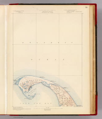
Full Title
Massachusetts. Provincetown sheet. Preliminary edition subject to corrections. U.S. Geological Survey, J.W. Powell, Director. State of Massachusetts ... commissioners. Henry Gannett, Chief Geographer. Marcus Baker, geographer in charge. Triangulation by the U.S. Coast and Geodetic and Borden surveys. Coast line by the U.S. Coast Survey. Topography by the U.S. Geological Survey and U.S. Coast Survey. Surveyed in 1887. Forbes Co., Boston & N.Y. (1890)
Publisher
Topographical Survey Commission
Author
[Geological Survey (U.S.), Massachusetts. Topographical Survey Commission]
Full Title
Massachusetts. Wellfleet sheet. Preliminary edition subject to corrections. U.S. Geological Survey, J.W. Powell, Director. State of Massachusetts ... commissioners. Henry Gannett, Chief Geographer. Marcus Baker, geographer in charge. Triangulation by the U.S. Coast and Geodetic Survey. Topography by the U.S. Coast and Geodetic Survey and by E.B. Clark. Surveyed in 1887. Forbes Co., Boston & N.Y. (1890)
Publisher
Topographical Survey Commission
Author
[Geological Survey (U.S.), Massachusetts. Topographical Survey Commission]
Full Title
Massachusetts. Yarmouth sheet. Preliminary edition subject to corrections. U.S. Geological Survey, J.W. Powell, Director. State of Massachusetts ... commissioners. Henry Gannett, Chief Geographer. Marcus Baker, geographer in charge. Triangulation and coast line by the U.S. Coast and Geodetic Survey. Topography by E.B. Clark. Surveyed in 1886-7. Forbes Co., Boston & N.Y. (1890)
Publisher
Topographical Survey Commission
Author
[Geological Survey (U.S.), Massachusetts. Topographical Survey Commission]
Full Title
Massachusetts. Nantucket sheet. Preliminary edition subject to corrections. U.S. Geological Survey, J.W. Powell, Director. State of Massachusetts ... commissioners. Henry Gannett, Chief Geographer. Marcus Baker, geographer in charge. Triangulation and coast line by the U.S. Coast and Geodetic Survey. Topography by E.B. Clark, assistant topographer. Surveyed in 1887. Forbes Co., Boston & N.Y. (1890)
Publisher
Topographical Survey Commission
Author
[Geological Survey (U.S.), Massachusetts. Topographical Survey Commission]
Full Title
Massachusetts. Chatham sheet. Preliminary edition subject to corrections. U.S. Geological Survey, J.W. Powell, Director. State of Massachusetts ... commissioners. Henry Gannett, Chief Geographer. Marcus Baker, geographer in charge. Compiled chiefly from U.S. Coast and Geodetic Survey. Forbes Co., Boston & N.Y. (1890)
Publisher
Topographical Survey Commission
Author
[Foote, C.M., Henion, J.W.]
Full Title
Outline Map of Columbia Co., Wisconsin.
Publisher
C.M. Foote & Co.
Author
[Foote, C.M., Henion, J.W.]
Full Title
Wisconsin.
Publisher
C.M. Foote & Co.
Author
[Foote, C.M., Henion, J.W.]
Full Title
Plat of Randolph, Township 13 North, Range 12 East of the Fourth Principal Meridian, Columbia Co., Wisconsin.
Publisher
C.M. Foote & Co.
Author
[Foote, C.M., Henion, J.W.]
Full Title
Randolph, Westford Twp. Dekorra. Rio, Otsego Tp. Okee, Lodi Twp.
Publisher
C.M. Foote & Co.
Author
[Foote, C.M., Henion, J.W.]
Full Title
Plat of Scott Township 13 North, Range 11 East of the Fourth Principal Meridian, Columbia Co., Wis.
Publisher
C.M. Foote & Co.
Author
[Foote, C.M., Henion, J.W.]
Full Title
Plat of Marcellon, Township 13 North, Range 10 East of the Fourth Principal Meridian, Columbia Co., Wis.
Publisher
C.M. Foote & Co.
Author
[Foote, C.M., Henion, J.W.]
Full Title
Plat of Fort Winnebago, Township 13 North, Range 9 East of the Fourth Principal Meridian, Columbia Co., Wis.
Publisher
C.M. Foote & Co.
|