Who What Where When |
Author
[Peseux, M., United States. War Department]
Full Title
Battle-fields in front of Nashville, Tenn., where the United States forces commanded by Major-General Geo. H. Thomas, defeated and routed the rebel army under General Hood, December 15th and 16th 1864. Surveyed and drawn under the direction of Gen. Tower by M. Peseux, C.S. Mergell, auth. (with) Battle-field in front of Franklin, Tenn., where the United States forces ... under the command of Maj. Gen. J.M. Schofield, severely repulsed the rebel army commanded by Lieutenant-General Hood, November 30th 1864. (with) Map of the battle-field of Waynesborough, Va., fought March 2d. 1865. Union cavalry commanded by Maj. Gen. P.H. Sheridan ... Confederate forces commanded by Lieut. Gen. J.A. Early. Surveyed and drawn under the direction of ... G.L. Gillespie ... by H.C. Koch. (with) Sketch of West Point, Ga. and line of defenses. Under supervision of Lieut. Heywood ... (with) Sketch of Saunders' Ford, Ala., on Mulberry Fork of the Black Warrior River. Surveyed and drawn by H.S. Heywood ... (with) Sketch of the camp of the Cav. Corps, M.D.M., extending from Eastport, Miss. to Gravelly Springs, Ala. from field notes of H.S. Heywood ... (with) Battle-field of Waynesborough, Va., 2d March 1865. Prepared by ... G.L. Gillespie ... 1873. Surveyed by John B. McMaster ... drawn by George B. Strauch. Julius Bien & Co., Lith., N.Y. (1891-1895)
Publisher
U.S. Government Printing Office
Author
[Gillespie, George L., United States. War Department]
Full Title
Engineer' Office, Military Division of the Gulf, map no. 6. Central Virginia, showing Maj. Gen. P.H. Sheridan's campaigns and marches of the Cavalry under his command in 1864-1865. Drawn and lithographed under the direction of ... Geo. L. Gillespie ... October 1865. Engineer Office, Military Division of the Gulf, map no. 3. Battle-field of Dinwiddie C.H., fought Friday March 31st 1865 ... Surveyed, drawn and lithographed under direction of ... G.L. Gillespie ... July 1865. Surveyed and drawn by Henry C. Koch. Drawn for stone by C.W. Drury. (with) Map of Montgomery, Ala. and its defenses. Drawn by Lieut H.S. Heywood ... from original projection by Brig. Gen. Leadbetter, C.S.A. (with) Sketch of Columbus, Ga. and its defenses. From survey made by Lieut. H.S. Heywood ... (with) Sketch of the battle-field of Ebenezer Church, Ala. Battle fought on the 1st day of April 1865 between the U.S. forces under Bvt. Maj. Gen. Wilson and the C.S. forces under Lieut. Gen. Forrest. Julius Bien & Co., Lith., N.Y. (1891-1895)
Publisher
U.S. Government Printing Office
Author
[Duane, James C., United States. War Department]
Full Title
Map showing the operations of the Army of the Potomac under command of Maj. Gen. George G. Meade, from March 29th to April 9th, 1865. J.C. Duane, Major of Engineers ... (with) Map of portions of Mississippi, Alabama and Georgia showing march of Cavalry Corps, Military Division of the Mississippi, from March 22d to April 20th 1865. (with) No. 3. Map showing routes of marches of the army of Gen. W.T. Sherman from Atlanta, Ga. to Goldsborough, N.C. ... (with) Plat showing the battle-ground at Rivers' Bridge, Big Salkehatchie River, S.C. (with) Chart accompanying project for effectually closing Cape Fear River and the port of Wilmington, N.C. to blockade runners. (with) Plans, sections and elevation of pile bridge, James River near Varina, Va., January 1865. W.R. King, 1st Lieut. U.S. Engrs. ... Julius Bien & Co., Lith., N.Y. (1891-1895)
Publisher
U.S. Government Printing Office
Author
[Michie, Peter S., Michler, Nathaniel, United States. War Department]
Full Title
Richmond, Va. From surveys under the direction of Bvt. Brig. Gen. N. Michler ... and P.S. Miche (i.e. Michie) ... by command of ... A.A. Humphreys. Surveyed by L. Dessez, G. Brown, E. Collett, Maj. J.E. Weyss, E. Theilkuhl, L.C. Oswell, G. Thompson, E. Schumann. Drawn by Maj. J.E. Weyss, G. Thompson, E. Schumann and J. Strasser, 1867. Petersburg and Five Forks, Va. From surveys under direction of ... N. Michler ... by command of ... A.A. Humphreys. 1867. Surveyed and drawn by Maj. J.E. Weyss, assisted by F. Theilkuhl, J. Strasser and G. Thompson. Bermuda Hundred, Va. ... 1867. Surveyed and drawn by Maj. J.E. Weyss, assisted by F. Theilkuhl, J. Strasser and G. Thompson. Jetersville and Sailor's Creek, Va. ... 1867. Surveyed and drawn by Maj. J.E. Weyss, assisted by F. Theilkuhl, J. Strasser and G. Thompson. Julius Bien & Co., Lith., N.Y. (1891-1895)
Publisher
U.S. Government Printing Office
Author
[Michler, Nathaniel, United States. War Department, Weyss, John E.]
Full Title
Sketch of routes from Petersburg, Chester Station and Manchester to Amelia Court-House, Va. By order of Col. T.M.R. Talcott, Com'dg. Engr., Troops, A.N. Va. Appomattox Court-House, Va. From surveys under the direction of ... N. Michler ... by command of ... A.A. Humphreys ... 1867. Surveyed and drawn by Maj. J.E. Weyss, assisted by F. Theilkuhl, J. Strasser and G. Thompson. High Bridge and Farmville, Va. From surveys under the direction of ... N. Michler ... 1867. Surveyed and drawn by Maj. J.E. Weyss, assisted by F. Theilkuhl, J. Strasser and G. Thompson. (with) Sketch of roads to Corinth, Miss. (with) Petersburg mine explosion, June 30, 1864. (with) Pittsburg, Tenn., March 24, 1862. Julius Bien & Co., Lith., N.Y. (1891-1895)
Publisher
U.S. Government Printing Office
Author
United States. War Department
Full Title
Map of the environs of Petersburg, Va. from the Appomattox River to Ft. Howard, showing the positions of the intrenched lines occupied by the 9th Army Corps, A.P., during the siege. Plat showing the positions of the Army of the Tennessee under command of Maj. Gen. O.O. Howard during the battle of Bentonville, N.C., March 20th and 21st 1865. Map showing the march routes of the Army of the Tennessee under the command of Maj. Gen. O.O. Howard during the winter campaign in the Carolinas. Surveyed and compiled under the direction of Col. C.B. Reese ... Drawn and compiled by L. Helmle ... Surveys by W. Griswold and J. Weld ... Topographical map showing the positions of the 14th and 20th Corps commanded by Maj. Gen. H.W. Slocum, and Kilpatrick's Cavalry in an engagement near Bentonville, N.C., March 19th, 1865. R.M. McDowell, Capt. and Top. Engr, Army of Ga. Map of battle of Averysborough, N.C., fought March 16th, 1865. Map of the battle-field of Pea Ridge, Ark. showing the positions of the United States and Confederate forces on the 8th of March, 1862. ... Published ... 1876. Plan no. 8, siege operations at Spanish Fort, Mobile Bay, by the U.S. forces under Maj. Gen. E.R. Canby. Captured by the Army of West Mississippi, on the night of April 8 and 9, 1865, Major M.D. McAlester, Senior Engr., Major J.C. Palfrey, Asst. Engr., Capt. C.J. Allen, Asst. Engr., Capt. Patten ... Asst. Engr. Julius Bien & Co., Lith., N.Y. (1891-1895)
Publisher
U.S. Government Printing Office
Author
[Campbell, Albert H., Confederate States of America. Army of Northern Virginia, Confederate States of America. Army, Hotchkiss, Jed.]
Full Title
No. 1. Map from Maj. A.H. Campbell's surveys showing the positions of the camps and pickets of the 2d Corps, A.N. Va., May 3d 1864 and the routes of march from May 4th to May 21st 1864, battles of the Wilderness and Spotsylvania C.H., Va. To accompany report of Jed. Hotchkiss, Top. Eng., V.D. No. 5. Map from Maj. A.H. Campbell's surveys showing the routes and positions of the 2d Corps, A.N. Va., to accompany report of Jed. Hotchkiss ... No. 7. Map from Maj. A.H. Campbell's surveys showing the routes, camps and positions of the 2d Corps, A.N. Va. from May 27th to June 13th 1864 to accompany report of Jed. Hotchkiss ... No. 11. Map showing routes and camps of the Army of the Valley Dist. from Staunton, Va. to Washington, D.C. and back to Strasburg, Va. from June 27th to July 22d 1864, to accompany report of Jed. Hotchkiss ... (with) No. 99. Wickham's attack on Fed. Cav., Nov. 22d 1864. (with) No. 8. Map showing the routes and camps of the 2d Corps, A.N.V. from Gaines' Mill to Lynchburg, Va., June 13th to 18th 1864 and of the Army of the Valley District from Lynchburg to Salem and Staunton, Va., June 19th to 27th, 1864. (with) No. 6. Map from Maj. A.H. Campbell's surveys showing position of 2d Corps, A.N. Va., at Hanover Junction, Va., May 22d to May 27th 1864 ... Julius Bien & Co., Lith., N.Y. (1891-1895)
Publisher
U.S. Government Printing Office
Author
[Confederate States of America. Army of Northern Virginia, Confederate States of America. Army, Hotchkiss, Jed.]
Full Title
No. 29. Sketch of the battle of Belle Grove on Cedar Creek, Wednesday October 19th 1864. Prepared to accompany report of Lieut. Gen. J.A. Early, commanding A.V.D., by Jed. Hotchkiss, Top. Eng. A.V.D. (with) No. 12. Map of engagement at Harper's Ferry, Va., July 4th, 1864. (with) No. 17. Map of cavalry action at Martinsburg, Va., July 25th, 1864. (with) No. 18. Map showing routes, camps and engagements of McCausland's and Johnson's brigades of Cavalry from July 29th to August 8th 1864, burning of Chambersburg. (with) No. 19. Sketch of action at Guard Hill, Aug. 16th 1864. (with) No. 21. Sketch of actions near Kearneysville and Shepherdstown, Va., Thursday August 25th 1864. (with) No. 20. Sketch of engagement at Charlestown, Va., Sunday Aug. 21st 1864. (with) No. 22. Sketch of engagement at Opequon Bridge and Smithfield, Va., Monday Aug. 29th 1864. (with) No. 24. Sketch of the cavalry action of Fitz Lee's division at Gooney Run, Warren Co., Va., Tuesday Sept. 20th 1864. (with) No. 23. Sketch of the battle of Berryville, Va. by Kershaw's division, Saturday Sept. 3d 1864 and position of the Army of the Valley, Sunday Sept. 4th 1864. (with) No. 26. Map of the line of intrenchments (sic) at Fisher's Hill, Va., Aug. 13th to 17th 1864, Battle of Fisher's Hill, Sept. 22d 1864. (with) No. 27. Map of cavalry engagement near Bridgewater, Va., Oct. 4th and 5th 1864 by Jed. Hotchkiss ... Julius Bien & Co., Lith., N.Y. (1891-1895)
Publisher
U.S. Government Printing Office
Author
[Confederate States of America. Army of Northern Virginia, Confederate States of America. Army, Hotchkiss, Jed.]
Full Title
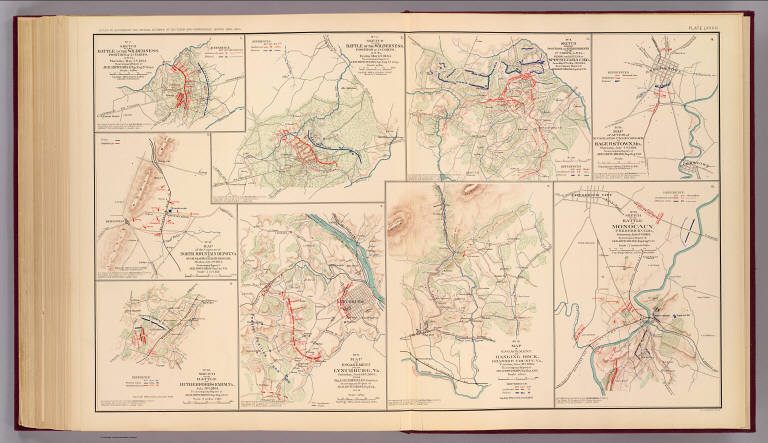
No. 10. Map of engagement at Hanging Rock, Roanoke County, Va., Tuesday, June 21st, 1864. No. 15. Sketch of the battle Monocacy, Frederick Co., Md., Saturday July 9th 1864. (with) No. 2. Sketch of the battle of the Wilderness. Position of 2d Corps. A.N. Va., Thursday May 5th 1864. (with) No. 3. Sketch of the battle of the Wilderness. Position of 2d Corps, A.N. Va., Friday May 6th 1864. (with) No. 4. Sketch showing positions and entrenchments of the 2d Corps, A.N. Va., during the battles of Spotsylvania C.H., Va. from May 9th to May 21st 1864. (with) No. 14. Map of action of McCausland's cavalry brigade at Hagerstown, Md., Thursday July 7th 1864. (with) No. 13. Map of the capture of North Mountain Depot, Va. by McCausland's cavalry brigade, Monday July 4th 1864. (with) No. 16. Sketch of the battle of Rutherford's Farm, Va., July 20th 1864. (with) No. 9. Map of engagement near Lynchburg, Va., Saturday June 18th 1864, from Maj. A.H. Campbell's surveys. (all) To accompany report of Jed. Hotchkiss, Top. Eng. ... Julius Bien & Co., Lith., N.Y. (1891-1895)
Publisher
U.S. Government Printing Office
Author
[Confederate States of America. Army of Northern Virginia, Confederate States of America. Army, Hotchkiss, Jed.]
Full Title
No. 25. Sketch of the cavalry engagement at Milford, Va., of Fitz Lee's division, Wednesday Sept. 21st, 1864, to accompany report of Jed. Hotchkiss ... No. 28. Cavalry action of Gen. Rosser near Brock's Gap, Va., Oct. 6th 1864. No. 30. Sketch of action of Gen. Rosser's cavalry near Moorefield, Va., Sunday Nov. 27th 1864. No. 31. Map of New Creek and vicinity showing position of Fort Kelley and the Federal camp captured by ... Rosser's Cav. Div., A.N.V., Monday Nov. 28th 1864. No. 36. Capture of Beverly, Randolph Co., Va. by Gen. Rosser, Jan. 11th 1865. No. 32. Map of Gen. Rosser's night attack on Custer's division at Lacey Spring, Va., Wednesday Dec. 21st 1864. No. 33. Sketch of cavalry action at Liberty Mills, Va., Friday Dec. 23d 1864. No. 34. Sketch of cavalry engagement of Gen. Lomax near Gordonsville, Va., Dec. 24th 1864. No. 37. Map showing positions of the camps and pickets of the Army of the Valley District, January 31st 1865. No. 35. Map showing routes of Rosser's division to Beverly, Va. and back, Jan. 7th to Jan. 18th 1865. No. 38. Sketch of Gen. Rosser's attack on Federal cavalry guarding prisoners at Rude's Hill, Va., Tuesday March 7th 1865. (with) Sketches accompanying journal of Capt. Jed. Hotchkiss, C.S. Army. (most) by Jed. Hotchkiss, Top. Eng. ... Julius Bien & Co., Lith., N.Y. (1891-1895)
Publisher
U.S. Government Printing Office
Author
[Confederate States of America. Army of Northern Virginia, Confederate States of America. Army, Hotchkiss, Jed.]
Full Title
Map of route of the Army of the Valley from Franklin, Pendleton Co., Va. May 15th 1862 to the battle of Winchester, May 25th 1862 and the pursuit of the enemy ... 1863. Sketch of the battle of Winchester, Va., Sunday May 25th 1862 ... Route of Gen. Jackson's army to the battle of Cedar Run, Va. ... 1863. Sketch of the battle of Cedar Run, Va., Saturday August 9th 1862 ... Sketch of the battles of Port Republic, Va., June 8th and 9th 1862 ... (all) by Jed. Hotchkiss ... (with) Sketches accompanying journal of Capt. Jed. Hotchkiss, C.S. Army, Chief Engr. 2d Corps, A. of N.V., Valley District. Julius Bien & Co., Lith., N.Y. (1891-1895)
Publisher
U.S. Government Printing Office
Author
United States. War Department
Full Title
Sketch showing the positions of the union and rebel forces as situated on the 30th of November, 1863 in the vicinity of Mine Run, in Orange County, Va. (with) Map showing the picket line of the First and Third Cavalry divisions, Cavalry Corps, Army of the Potomac, by Capt. V.E. von Koerber, Topographical Engineers, U.S. Army. (with) Camp of the Army of the Potomac near Brandy Station, Va. (with) Map showing the position of the Army of Northern Virginia, from records of the Bureau of Information, U.S. Army. April 13, 1864. (with) Tracing of the picket-line, 4th Div., 2d Army Corps. (with) Maj. Gen. French's position in front of Atlanta, Ga. Julius Bien & Co., Lith., N.Y. (1891-1895)
Publisher
U.S. Government Printing Office
Author
United States. War Dept. Engineer Bureau
Full Title
Defenses of Washington. Extract of military map of N.E. Virginia, showing forts and roads. Engineer Bureau, War Department, 1865. Map of the city of Richmond, Va. From a survey by I.H. Adams, Assist. U.S. Coast Survey, 1858. With additions from Smith's map of Henrico County, 1853. Prepared at the U.S. Coast Survey office, A.D. Bache, Supt., 1864. Julius Bien & Co., Lith., N.Y. (1891-1895)
Publisher
U.S. Government Printing Office
Author
[Abbot, Henry L., United States. War Department]
Full Title
Department of the Gulf. Map no. 5. Approaches to New Orleans, prepared by order of Maj. Gen. N.P. Banks (by) Henry L. Abbot, Capt. and Chief Top. Engrs., Feb. 14th, 1863. (with Fairburn, Ga., Aug. 15-16, 1864). (with) Position of Army of Tennessee near Atlanta, Ga., July 22, 1864. (with) Map of Spanish Fort, Ala., made during the siege by Lieut. J.A. Chalaron ... (with) Diagrams illustrating the different positions occupied by the 4th Division, 17th Army Corps, during the battle of Atlanta, Ga., July 22, 1864. (with) Part of Paulding County, showing the position of the Left Wing, 16th A.C., June 4, 1864. (with) Section of a map showing the lines new New Hope Church, Ga., 1864. From Chief Engineer's Office, Army of Mississippi, by Capt. W.J. Morris, Chief Engineer. (with) Topographical sketch of the position of the Second Division, 14th Army Corps, in front of Savannah, Ga., December 11th, 1864. Brig. Gen. Jas. D. Morgan, commanding Division. Surveyed and drawn by Chas. Petri ... (with) Map of the vicinity of Mechanicsville, Va. (with Spanish Fort, Ala., March 29-April 8, 1865. Chas. G. Johnson). (with) Spanish Fort, 1865. Drawn during siege by assistant surgeon Bull, C.S. Army. Julius Bien & Co., Lith., N.Y. (1891-1895)
Publisher
U.S. Government Printing Office
Author
[Campbell, Albert H., Confederates States of America. Army of Northern Virginia, Henderson, D. E.]
Full Title
Chief Engineer's Office, D.N.V. Maj. Gen. J.F. Gilmer, Chief Engineer. Map of Spotsylvania County. Made under direction of A.H. Campbell, Capt. Engrs. in chg. Topl. Dept. General map. The vicinity of Hanover Junction, Va. and its defenses. Made under the direction of Capt. A.H. Campbell ... by Lieut. D.E. Henderson, Provl. Engrs., C.S. Army. (with) D. Sketch showing route pursued in the advance to Goldsborough, N.C. in December 1862. (with) Sketch showing position of Boyd's Neck, Honey Hill and Devaux's Neck, S.C. in December 1864. (with) Sketch of Spanish Fort defenses made during the siege by Lieut. J.A. Chalaron. Julius Bien & Co., Lith., N.Y. (1891-1895)
Publisher
U.S. Government Printing Office
Author
[Campbell, Albert H., Confederates States of America. Army of Northern Virginia]
Full Title
Chief Engineer's Office, D.N.Va. Maj. Gen. J.F. Gilmer, Chief Engineer. Map of the vicinity of Richmond, Va., and part of the Peninsula. From surveys made under the direction of Capt. A.H. Campbell, P.E.C.S.A., in charge, Topographical Department, D.N.Va. 1864. (with) Part of Hanover County. Map. 1, Section 2. (with) Part of New Kent County. Map 1, Section 3. (with) Map 1, Section 3. Julius Bien & Co., Lith., N.Y. (1891-1895)
Publisher
U.S. Government Printing Office
Author
[Campbell, Albert H., Confederates States of America. Army of Northern Virginia]
Full Title
Chief Engineer's Office, D.N.V., Maj. Gen. J.F. Gilmer, Chief Eng'r. Preliminary map of a part of the south side of James River, Va. From surveys and reconnaissances made under the direction of Capt. A.H. Campbell, P.E., in ch'ge Top. Dept., D.N.V. 1864. J.H. Patton, Asst. Engr. (with) The battle-field of Chancellorsville, Va. Prepared by Bvt. Brig. Gen. N. Michler, Major of Engineers, from surveys under his direction. By order of ... A.A. Humphreys ... 1867. Surveyed and drawn by Maj. J.E. Weyss, assisted by F. Theilkuhl, J. Strasser and C. (i.e. G.) Thompson. Julius Bien & Co., Lith., N.Y. (1891-1895)
Publisher
U.S. Government Printing Office
Author
[Confederates States of America. Army of Northern Virginia, Koerner, P. W. O.]
Full Title
A map of a line of defenses in the Alleghanies compiled from Whitcomb's railroad map and original surveys by Lieut. Koerner's topographical party under direction of Capt. C.R. Howard, C.S.E. H.J. Miller, asst. and drftsmn. Chief Engr. Office, D.N.V. Maj. Gen. J.F. Gilmer, Chf. Engr. Map of the Valley of Virginia from Staunton to Winchester from surveys and reconnaissances by P.W.O. Koerner, Lt. Engr. Made under direction of Major A.H. Campbell, Chf. Topl. Bureau, D.N.V. (with) Map of the battle-field about Frederick City and the Monocacy River, Md., July 9, 1864. Sketched and drawn by Ch's. F. Von Lindenberg. (with) Skirmish at Salineville, Ohio and surrender of Brig. Gen. John H. Morgan, C.S. Army (with) Position of the Union hospitals at Cold Harbor, Va., May 31, June 12, 1864. (with) Position of the Union hospitals at the battle of the Wilderness, Va., May 5-7, 1864. (with) Position of the Union hospitals at Spotsylvania Court-House, Va., May 9-21, 1864. (with) Copy of map furnished to Maj. Gen. G.K. Warren, commanding the Fifth Army Corps, by means of which to conduct operations beginning on March 29, 1865. (with) Map of field operations of March 29, 30 and 31, 1865 of the Fifth Army Corps commanded by Maj. Gen. G.K. Warren. Julius Bien & Co., Lith., N.Y. (1891-1895)
Publisher
U.S. Government Printing Office
Author
[United States. War Department, Weyss, John E.]
Full Title
Map of the battle-field of The Wilderness, Va., prepared by command of Brig. Gen. A.A. Humphreys, Chief of Corps of Engineers, U.S. Army. From surveys made under direction of Bvt. Brig. Gen. N. Michler, Major of Engineers. 1867. Surveyed and drawn by Maj. J.E. Weyss, assisted by E. Theilkuhl, J. Strasser and G. Thompson. Map of the battle-field of North Anna, Va. ... 1867. Map of the battle-field of Spotsylvania Court-House, Va. Compiled from surveys made under the direction of N. Michler ... and Bvt. Maj. C.W. Howell ... 1867. The battle-field of Totopotomoy, Va. From surveys under the direction of ... N. Michler ... and ... C.W. Howell ... by command of ... A.A. Humphreys ... 1867. ... (with) Chickamauga, Ga. Accompanying report of ... Patrick. R. Cleburne, C.S. Army. (with) Engineer's Office, Army of Miss., W.J. Morris, Capt. & Chief Engr. F.G. Gutherz, Asst. Engr., June 17th 1864 for Maj. Gen. French (Marietta Region, Ga.) Julius Bien & Co., Lith., N.Y. (1891-1895)
Publisher
U.S. Government Printing Office
Author
[Boyd, C. H., United States. War Department]
Full Title
Battle-field of Chickamauga, Ga. Surveyed by command of Maj. Gen. G.H. Thomas, commanding Dept. of the Cumberland, by Capt. C.H. Boyd, Sub-Asst., U.S.C.S., April and May, 1864. Assisted in levelling by Lieut. Kuntze and Sergeant Wilson, Top. Engineers, 2d Division, 14th Army Corps. (with) Map showing the army movements around Chattanooga, Tenn. made to accompany the report of Maj. Gen. U.S. Grant by direction of Brig. Gen. Wm. F. Smith ... Jan. 4th 1864, compiled and drawn by H. Riemann ... (with) Map of the battle-field of Cold Harbor, Va. From surveys under the direction of ... N. Michler ... and ... P.S. Michie ..., by command of ... A.A. Humphreys ... 1867. Surveyed and drawn by Maj. J.E. Weyss, assisted by F. Theilkuhl, J. Strasser and G. Thompson. Julius Bien & Co., Lith., N.Y. (1891-1895)
Publisher
U.S. Government Printing Office
Author
[Gillespie, George L., United States. War Department]
Full Title
Battle-field of Winchester, Va. September 19, 1864. Prepared by Bvt. Lt. Col. G.L. Gillespie, Major of Engineers, U.S.A. from surveys under his directions, by order of Lt. Gen. P.H. Sheridan ... 1873. George B. Strauch and E. Siegesmund, assistants. Battle-fields of Fisher's Hill and Cedar Creek, Virginia. 22 Sept. 1864, 19 Oct. 1864. Prepared by ... G.L. Gillespie ... by order of Lt. Gen. P.H. Sheridan ... 1873. George B. Strauch and E. Siegesmund, assistants. Julius Bien & Co., Lith., N.Y. (1891-1895)
Publisher
U.S. Government Printing Office
Author
United States. War Department
Full Title
Central Virginia showing Lieut. Gen. U.S. Grant's campaign and marches of the armies under his command in 1864-1865. Engineer Bureau, War Dept. (with) No. 12. Region embraced in the operations of the armies against Richmond and Petersburg, Va. Engraved at the Engineer Bureau, War Dept. Julius Bien & Co., Lith., N.Y. (1891-1895)
Publisher
U.S. Government Printing Office
Author
[Michler, Nathaniel, United States. War Department]
Full Title
Plan and section of batteries (or battery) ... on the main line of enemy's works in front of Petersburg, Va. Official: N. Michler, Major of Engineers, U.S.A. Siege of Petersburg, Va. from July 9th to July 31st, 1864 ... Official: N. Michler. Julius Bien & Co., Lith., N.Y. (1891-1895)
Publisher
U.S. Government Printing Office
Author
[McAlester, Miles D., McGregory, Samuel E., United States. War Department]
Full Title
Rebel defenses, Mobile, Ala., occupied by Union forces under Maj. Gen. E.R.S. Canby April 12, 1865. Drawn by order of Maj. McAlester, Chief Engineer, Army and Division West Miss. under direction of Lieut. S.E. McGregory ... (with) Headquarters, Army of the Potomac, Engineer Dept., June 18th, 1864. This map exhibits the lines of the enemy in our possession up to date. N. Michler. (with) Sketch of affair at Rappahannock Station, Va., March 28th 1862. (with) Position of the 3d Division, 23d Army Corps at Columbia, Tenn., Nov. 24th-29th 1864. (with) Operations from New Berne, N.C. to Kinston, of Provisional Corps under command of Maj. Gen. J.D. Cox, U.S. Army, March 1-20, 1865. (with) Sketch of the battle-field of West Harpeth River, Tenn., December 17th 1864. Bvt. Maj. Gen. James H. Wilson, comdg. (with) E. no. 1. Sketch of the main line of the enemy's works in front of Petersburg, Va., upon the advance of the United States forces, June 1864. Official: N. Michler. (with) Map accompanying the report of Maj. Gen. J.D. Cox ... of operations of the 3d Division, 23d Army Corps and other forces under his command during the operations in front of Wilmington, N.C. in February 1865. (with) Sketch showing the disposition of the Cavalry Corps, Military Division of the Miss. ... James H. Wilson, commanding, at the battle of Franklin, Tenn., November 30, 1864. By F. Tunica, Engineer ... Julius Bien & Co., Lith., N.Y. (1891-1895)
Publisher
U.S. Government Printing Office
Author
[McGregory, Samuel E., United States. War Department]
Full Title
Rebel lines. Mobile defenses. Fort Sidney Johnson, N, on Lieut. Col. V. Sheliha's line of works. Drawn by order of Maj. McAlester, Chief Engineer ... under direction of Lieut. S.E. McGregory ... H. Holtz, del. (with) D. No. 7. Siege of Petersburg, Va., from July 9th to July 31st 1864. Siege battery and mortar battery. Constructed under the direction of Major J.C. Duane ... by ... G.L. Gillespie. (with) D. No. 4. Siege of Petersburg, Va. ... 1864. Fort Prescott ... (with) D. No. 3. Siege of Petersburg, Va. ... 1864. Field battery ... (with) D. No. 8. Siege of Petersburg, Va. ... 1864. Field battery ... (with) Drawings of rifle projectiles used by the U.S. forces in the Virginia Campaign of 1864. (with) Rebel lines. Mobile defenses. Redan nos. 7 and 8 ... C.A. Czartoryski ... (with) Rebel lines. Mobile defenses. Battery McIntosh, water battery. C.A. Czartoryski. Julius Bien & Co., Lith., N.Y. (1891-1895)
Publisher
U.S. Government Printing Office
Author
[Hotchkiss, Jed., United States. War Department]
Full Title
Defenses of Chattanooga, Tenn. (with) Battle of Cross Keys, Va., June 8, 1862 by Jed. Hotchkiss ... Sketch showing positions of Second Corps, A.N.Va., August 26th to September 2, 1862 embracing engagements at Bristoe Station, Manassas Junction, Groveton or Second Bull Run and Ox Hill or Chantilly, Va. Prepared to accompany report of Lieut. Gen. Thos. J. Jackson by Jed. Hotchkiss ... Jan. 1863. Map of the battle-field of Chickamauga, Ga. and vicinity, fought September 18th, 19th and 20th 1863. Charles Foster, draughtsman. (with) Sketch showing position of Confederate and Federal armies at Franklin, Va., May 9th to 11th 1862 by Jed. Hotchkiss ... (with) Defenses of Cleveland, Tenn. (with) Defenses of Knoxville, Tenn. (with) Defenses of Loudon, Tenn. (with) Defenses of Charleston, Tenn. (with) Defenses of Chattanooga, Tenn. Plan of Fort Phelps. Reduced from a plan furnished by Col. W.E. Merrill ... April 18th 1865. (with) Defenses of Chattanooga, Tenn. Fort Creighton. (with) Defenses of Chattanooga, Tenn. Battery Bushnell. (with) Defenses of Chattanooga, Tenn. Lunette O'Meara. (with) Defenses of Chattanooga, Tenn. Redoubt Putnam. (with) Defenses of Chattanooga, Tenn. Fort Jones. Julius Bien & Co., Lith., N.Y. (1891-1895)
Publisher
U.S. Government Printing Office
Author
[Confederate States of America. Army of Northern Virginia, Confederate States of America. Army, Hotchkiss, Jed.]
Full Title
Route map of Gettysburg campaign. Prepared by order of Lieutenant-General T.J. Jackson, January to April 1863 by Jed. Hotchkiss, Top. Eng., 2d Corps, A.N.Va., and used during that campaign by General R.E. Lee and Lieutenant-General R.S. Ewell, C.S. Army. (with) Sketch of the battle of McDowell, Va. on Thursday May 8th 1862 (Jackson) by Jed. Hotchkiss ... (with) Sketch accompanying the report of Capt. Joseph Badger, 8th Ohio Vol. Cav. of scout through Pocahontas and Highland counties, W. Va., April 15-22, 1865. (with) Operations in N. Va., W. Va. and Md. Map of route to McDowell. Julius Bien & Co., Lith., N.Y. (1891-1895)
Publisher
U.S. Government Printing Office
Author
Johnson, A.J.
Full Title
Johnson's Virginia, Delaware, Maryland, and West Virginia. Published by A. J. Johnson, New York. Johnson's Delaware and Maryland. Published by A. J. Johnson, New York. 46. 47. Entered according to the Act of Congress, in the year 1864, by A.J. Johnson in the Clerk's Office of the District Court of the United States for the Southern District of New York.
Publisher
A.J. Johnson.
Author
Tanner, Henry S.
Full Title
Virginia, Maryland, Delware. By H.S. Tanner. American Atlas. Engraved and Published by H.S. Tanner, Philadelphia. Entered according to Act of Congress, 20th Day of Decr. 1820, by H.S. Tanner, of the State of Pennsylvania.
Publisher
Henry Tanner
Author
[Bourquin, Frederick, Mitchell, Samuel Augustus, Tanner, Henry S.]
Full Title
A New Map of Virginia with its Canals, Roads & Distances from place to place along Stage and Steam Boat Routes. Entered according to Act of Congress. 17.
Publisher
S. Augustus Mitchell.
Author
Asher & Adams
Full Title
Asher & Adams' Delaware, Maryland, Virginia, West Virginia & District of Columbia. Entered according to Act of Congress 1874 by Asher & Adams in the Office of the Librarian of Congress at Washington.
Publisher
Asher & Adams.
Author
Lucas, Fielding Jr.
Full Title
Virginia. 21. H.S. Tanner, sc. (1816)
Publisher
[Fielding Lucas, Philip H. Nicklin.]
Full Title
Carte geographique, statistique et historique de la Virginie. Virginie. R. Thuillier fils, Place de l'Estrapade, No. 34. Fonderie et Imprimerie de J. Carez. (1825)
Publisher
J. Carez
Full Title
Virginia. (Published by George F. Cram, Chicago, Ill. 1909)
Publisher
E.A. Davis
Author
Bache, A. D.
Full Title
Sea Coast of Delaware, Maryland and part of Virginia. From a trigonometrical survey under the direction of A.D. Bache, Superintendent of the Survey of the Coast of the United States. Triangulation by J. Farley, E. Blunt & J.E. Johnstone, Capt. Top. Engrs., assistants. Topography by J.J.S. Hassler & G.D. Wise, assts. & W.M. Johnson, sub. asst. Hydrography by the parties under the command of T.R. Gedney, Lieuts. G.M. Bache, S.P. Lee, R. Bache & J.J. Almy, U.S. Navy, assistants U.S. Coast Survey. Published in 1852.
Publisher
U.S.
Author
Cram, George Franklin
Full Title
Cram's Rail Road & Township Map of Virginia & W.V. Published by Geo. F. Cram. Proprietor of the Western Map Depot. 66, Lake St. Chicago Ills. 1875.
Publisher
Cram Atlas Company
Full Title
Virginia. (Written and engraved by Jos. Perkins. 1845)
Publisher
Tanner's Geographical Establishment
Full Title
Virginia. (Philadelphia: Published by Robert Desilver, 1822)
Publisher
Robert DeSilver
Author
Rand McNally and Company
Full Title
Virginia and West Virginia. Rand, McNally & Co., Engr's., Chicago. Copyright, 1884, by Rand, McNally & Co., Map Publishers, Chicago. (1885)
Publisher
Waterman, Watkins & Co.
Author
Hotchkiss, Jed.
Full Title
Map of Augusta County, Virginia. By Jed. Hotchkiss, Top. Eng. Staunton, Va. 1885.
Publisher
Waterman, Watkins & Co.
Author
Hotchkiss, Jed.
Full Title
Map of Middle River Magisterial District, Augusta County, Virginia. By Jed. Hotchkiss, T.E. (with) Plan of Mount Sidney Town ... (with) Plan of New Hope Village ... (both) Middle River District. 1884 (1885)
Publisher
Waterman, Watkins & Co.
Author
Hotchkiss, Jed.
Full Title
Map of North River Magisterial Dist., Augusta County, Virginia. By Jed. Hotchkiss, T.E. 1884 (1885)
Publisher
Waterman, Watkins & Co.
Author
[Dudley, G.W., Hotchkiss, Jed., Ker, Sev. P.]
Full Title
Maps of the town of Waynesboro, the village of North Waynesboro, and the village of Waynesboro Junction, South River District, Augusta Co., Va. By Jed. Hotchkiss., T.E., 1884. The map of Waynesboro is from map of G.W. Dudley, C. & M.E., revised by Sev. P. Ker, who added portions beyond corporation lines. (1885).
Publisher
Waterman, Watkins & Co.
Author
Hotchkiss, Jed.
Full Title
Map of The Pastures Magisterial Dist., Augusta County, Virginia. By Jed. Hotchkiss, T.E. 1884 (1885)
Publisher
Waterman, Watkins & Co.
Author
[Hotchkiss, Jed., Ker, Sev. P.]
Full Title
Plan of Fishersville Village, South River District, by Jed. Hotchkiss, T.E. 1884. Plan of Churchville Village, The Pastures District, by Jee (sic) Hotchkiss, T.E. Surveyed by Ser. P. Ker. (with) Plan of Spring Hill Village (Long Glade P.O.) ... (with) Plan of Centerville Village (Milnesville P.O.) ... (with) Plan of Sangersville Village ... (with) Plan of Mount Solen Village ... (with) Plan of Craigsville Village ... (with) Plan of Middlebrook Village ... (all) by Jed. Hotchkiss, T.E. (1885)
Publisher
Waterman, Watkins & Co.
Author
Hotchkiss, Jed.
Full Title
Map of the city of Staunton, Augusta Co., Va. By Jed. Hotchkiss, Top. Eng. 1884 (1885)
Publisher
Waterman, Watkins & Co.
Author
Rand McNally and Company
Full Title
Rand McNally junior auto road map Delaware, Maryland, Virginia, West Virginia. Copyright by Rand McNally & Co., Chicago, Ill. (1927)
Publisher
Rand McNally
Author
Rand McNally and Company
Full Title
Philadelphia and vicinity. Pittsburgh and vicinity. Richmond and vicinity. Baltimore-Washington and vicinity. Copyright by Rand McNally & Co., Chicago, Ill. (1927)
Publisher
Rand McNally
Author
Greenleaf, Jeremiah
Full Title
Virginia. (with) The Western Part of Virginia.
Publisher
J. Greenleaf.
|