Who What Where WhenREMOVE |
Author
Duflot de Mofras, Eugene
Full Title
(Covers to) Exploration Du Territoire De L'Oregon, Des Californies Et De La Mer Vermeille, Executee Pendant Les Annees 1840, 1841 Et 1842, Par M. Duflot De Mofras, Attache A La Legation De France A Mexico. Ouvrage Publie Par Ordre Du Roi, Sous Les Auspices De M. Le Marechal Soult, Duc De Dalmatie, President du Conseil, Et De M. Le Ministre Des Affaires Etrangeres. Tome Premier. Paris, Arthus Bertrand, Editeur, Libraire De La Societe De Geographie, Rue Hautefeuille, No. 23. 1844. Paris. - Typographie de Firmin Didot Freres, rue Jacob, 56 ... Tome Second ... Atlas (with map) Carte De La Cote De L'Amerique Sur L'Ocean Pacifique Septentrional comprenant Le Territoire De L'Oregon, Les Californies, La Mer Vermeille ...
Publisher
Arthus Bertrand
Author
Duflot de Mofras, Eugene
Full Title
(Half Title Page to) Exploration Du Territoire De L'Oregon, Des Californies Et De La Mer Vermeille, Executee Pendant Les Annees 1840, 1841 Et 1842, Par M. Duflot De Mofras, Attache A La Legation De France A Mexico. Ouvrage Publie Par Ordre Du Roi, Sous Les Auspices De M. Le Marechal Soult, Duc De Dalmatie, President du Conseil, Et De M. Le Ministre Des Affaires Etrangeres. Tome Premier. Paris, Arthus Bertrand, Editeur, Libraire De La Societe De Geographie, Rue Hautefeuille, No. 23. 1844. Paris. - Typographie de Firmin Didot Freres, rue Jacob, 56 ... Tome Second ... Atlas (with map) Carte De La Cote De L'Amerique Sur L'Ocean Pacifique Septentrional comprenant Le Territoire De L'Oregon, Les Californies, La Mer Vermeille ...
Publisher
Arthus Bertrand
Author
Duflot de Mofras, Eugene
Full Title
(Title Page to) Exploration Du Territoire De L'Oregon, Des Californies Et De La Mer Vermeille, Executee Pendant Les Annees 1840, 1841 Et 1842, Par M. Duflot De Mofras, Attache A La Legation De France A Mexico. Ouvrage Publie Par Ordre Du Roi, Sous Les Auspices De M. Le Marechal Soult, Duc De Dalmatie, President du Conseil, Et De M. Le Ministre Des Affaires Etrangeres. Tome Premier. Paris, Arthus Bertrand, Editeur, Libraire De La Societe De Geographie, Rue Hautefeuille, No. 23. 1844. Paris. - Typographie de Firmin Didot Freres, rue Jacob, 56 ... Tome Second ... Atlas (with map) Carte De La Cote De L'Amerique Sur L'Ocean Pacifique Septentrional comprenant Le Territoire De L'Oregon, Les Californies, La Mer Vermeille ...
Publisher
Arthus Bertrand
Author
Duflot de Mofras, Eugene
Full Title
(Index to) Exploration Du Territoire De L'Oregon, Des Californies Et De La Mer Vermeille, Executee Pendant Les Annees 1840, 1841 Et 1842, Par M. Duflot De Mofras, Attache A La Legation De France A Mexico. Ouvrage Publie Par Ordre Du Roi, Sous Les Auspices De M. Le Marechal Soult, Duc De Dalmatie, President du Conseil, Et De M. Le Ministre Des Affaires Etrangeres. Tome Premier. Paris, Arthus Bertrand, Editeur, Libraire De La Societe De Geographie, Rue Hautefeuille, No. 23. 1844. Paris. - Typographie de Firmin Didot Freres, rue Jacob, 56 ... Tome Second ... Atlas (with map) Carte De La Cote De L'Amerique Sur L'Ocean Pacifique Septentrional comprenant Le Territoire De L'Oregon, Les Californies, La Mer Vermeille ...
Publisher
Arthus Bertrand
Author
Duflot de Mofras, Eugene
Full Title
Carte De La Cote De L'Amerique Sur L'Ocean Pacifique Septentrional Le Territoire De L'Oregon, Les Californies, La Mer Vermeille, Partie des Territoires de la Compagnie de la Baie d'Hudson, Et De L'Amerique Russe. Dressee par Mr. Duflot de Mofras, Attache a la Legation de France a Mexico; Pour servir a l'intelligence de son Voyage d'exploration Publie Par Ordre Du Roi, sous les Auspices De Mr. Le Marechal Duc De Dalmatie, Mr. Le Ministre Des Affaires Etrangeres. Paris, 1844. Le plan grave par Jacobs. L'ecriture gravee par Hacq. Publie par Arthus Bertrand.
Publisher
Arthus Bertrand
Author
Duflot de Mofras, Eugene
Full Title
Carte De L'Ocean Pacifique Au Nord De L'Equateur. No. 2. Publie Par Arthus Bertrand. Grave par S. Jacobs. Voyage de Mr. Duflot de Mofras.
Publisher
Arthus Bertrand
Author
Duflot de Mofras, Eugene
Full Title
Isthme de Tehuantepec. No. 3. Publie Par Arthus Bertrand. Voyage de Mr. Duflot de Mofras.
Publisher
Arthus Bertrand
Author
Duflot de Mofras, Eugene
Full Title
Plan Du Port Del Manzanillo Dans Le Territoire De Colma. No. 5. (with) Plan Du Port D'Acapulco sur la cote occidentale Du Mexique. No. 4. Publie Par Arthus Bertrand. Voyage de Mr. Duflot de Mofras.
Publisher
Arthus Bertrand
Author
Duflot de Mofras, Eugene
Full Title
Plan De Mazatlan. No. 7. (with) Plan De San Blas. No. 6. Publie Par Arthus Bertrand. Voyage de Mr. Duflot de Mofras.
Publisher
Arthus Bertrand
Author
Duflot de Mofras, Eugene
Full Title
Plan Du Port De Guaymas sur la Mer Vermeille. No. 9. (with) Plan De La Baie De La Paz Et Du Port De Pichilingue. No. 8. Publie Par Arthus Bertrand. Voyage de Mr. Duflot de Mofras.
Publisher
Arthus Bertrand
Author
Duflot de Mofras, Eugene
Full Title
Plan De L'Embouchure Du Rio Colorado dans la Mer Vermeille. No. 10. (with) Plan Du Port De S. Diego situe sur la cote septentrionale De La Californie. No. 11. Publie Par Arthus Bertrand. Voyage de Mr. Duflot de Mofras.
Publisher
Arthus Bertrand
Author
Duflot de Mofras, Eugene
Full Title
Mouillage De San Pedro. No. 12. (with) Mouillage De La Mission De Sta. Barbara. No. 13. Publie Par Arthus Bertrand. Voyage de Mr. Duflot de Mofras.
Publisher
Arthus Bertrand
Author
Duflot de Mofras, Eugene
Full Title
Plan du Port Et De La Baie De Monte-Rey situes sur la Cote Septle. de la Californie. No. 14. (with) Baie De La Trinidad. No. 15. Publie Par Arthus Bertrand. Voyage de Mr. Duflot de Mofras.
Publisher
Arthus Bertrand
Author
Duflot de Mofras, Eugene
Full Title
Port De San Francisco Dans La Haute Californie. No. 16. (with) Entree Du Port De San Francisco et des mouillages del Sausalito et de la Yerba Buena. Publie Par Arthus Bertrand. Grave par S. Jacobs. Voyage de Mr. Duflot de Mofras.
Publisher
Arthus Bertrand
Author
Duflot de Mofras, Eugene
Full Title
Carte Detaillee Du Mouillage Du Fort Ross et du Port De La Bodega ou Romanzoff dans la Nouvelle Californie, occupes par les Russes. No. 17. Publie Par Arthus Bertrand. Voyage de Mr. Duflot de Mofras.
Publisher
Arthus Bertrand
Author
Duflot de Mofras, Eugene
Full Title
Carte Du Rio Colombia Depuis Son Embouchure Jusqu' Au Fort Vancouver, a 17 Myriametres de la Mer. No. 18. Publie Par Arthus Bertrand. Voyage de Mr. Duflot de Mofras.
Publisher
Arthus Bertrand
Author
Duflot de Mofras, Eugene
Full Title
Port De Quadra ou De La Decouverte. No. 19. Plan Du Port De Nutka Cala de los Amigos. No. 20. Publie Par Arthus Bertrand. Voyage de Mr. Duflot de Mofras.
Publisher
Arthus Bertrand
Author
Duflot de Mofras, Eugene
Full Title
Port Du Port Mulgrave. No. 22. Plan Du Port De La Nouvelle Archangel Dans L'ile De Sitka Capitale des Etablissements de l'Amerique Russe. No. 21. Publie Par Arthus Bertrand. Voyage de Mr. Duflot de Mofras.
Publisher
Arthus Bertrand
Author
Duflot de Mofras, Eugene
Full Title
Vue De La Mission De Saint Louis Roi De France dans la Nouvelle Californie. No. 23 de l'Atlas. Publie Par Arthus Bertrand. Imp. par Lemercier. Lith par Muller. Voyage de Mr. Duflot de Mofras.
Publisher
Arthus Bertrand
Author
Duflot de Mofras, Eugene
Full Title
Plan Geometrique De La Mission De St. Louis Roi De France. Dans la Nouvelle Californie. No. 24 de l'Atlas. Paris Arthus Bertrand, Editeur. Grave sur pierre par Ch. Avril. Lith. de Bineteau. Voyage de Mr. Duflot de Mofras.
Publisher
Arthus Bertrand
Author
Duflot de Mofras, Eugene
Full Title
Tete De Chef Indien De La Cote Nord Ouest De L'Amerique. Armes et ustensiles des Indiens de la Nouvelle Californie. No. 25 de l'Atlas. Publie par Arthus Bertrand. Imp. par Lemercier. Lith. par Muller. Voyage de Mr. Duflot de Mofras.
Publisher
Arthus Bertrand
Author
Duflot de Mofras, Eugene
Full Title
Cranes Des Indiens Tetes Plates De La Cote Nord-Ouest De L'Amerique. Pl. 26 . Paris, Arthus Bertrand, Editeur. Lithographie par Werner. Imprime par Becquet. Atlas du Voyage de Mr. Duflot de Mofras.
Publisher
Arthus Bertrand
Author
Emory, William H.
Full Title
(Title Page to) Notes of a Military Reconnoissance, From Fort Leavenworth, In Missouri, To San Diego, In California, Including Part of the Arkansas, Del Norte, and Gila Rivers. By W.H. Emory, Brevet Major, Corps Topographical Engineers. Made in 1846-7, with the Advanced Guard of the "Army of the West." Washington: Wendell and van Benthuysen, Printers. 1848. [Senate] 30th Congress, 1st Session. Executive, No. 7.
Publisher
Wendell and Van Benthuysen
Author
Emory, William H.
Full Title
Military Reconnaissance Of The Arkansas Rio Del Norte And Rio Gila By W.H. Emory, Lieut. Top. Engrs. Assisted ... by J.W. Abert and W.G. Peck, and ... by W.H. Warner and Mr. Norman Bestor, Made in 1846-7, with the advance guard of the "Army of the West". Under Command Of Brig. Gen. Stephn. W. Kearny. Constructed under the orders of Col. J.J. Abert ... 1847. Drawn by Joseph Welch. Engraved on stone by E. Weber & Co. Baltimore.
Publisher
Wendell and Van Benthuysen
Author
Emory, William H.
Full Title
Map Of The United States And Their Territories Between The Mississippi And The Pacific Ocean And Part Of Mexico Compiled From The Surveys Made Under The Order Of W.H. Emory. ... And from the Maps of the Pacific Rail Road, General Land Office, and the Coast Survey. Projected and drawn under the supervision of Lt. N. Michler, Topl. Engrs. By Thomas Jekyll, C.E. 1857-8. Engraved by Selmar Siebert. Selmar Siebert's Engraving and Printing Establishment. Washington, D.C. Lettering by F. Courtenay. (above map) United States & Mexican Boundary Survey. General Map.
Publisher
Cornelius Wendell
Author
Emory, William H.
Full Title
(Title Page to) Report on the United States and Mexican Boundary Survey, Made Under The Direction of the Secretary of the Interior, By William H. Emory, Major First Cavalry And United States Commissioner ... Washington: Cornelius Wendell, Printer. 1857. House of Representatives, 34th Congress, 1st Session. Ex. Doc. No. 135. (Two volumes.)
Publisher
Cornelius Wendell
Author
Fremont, J.C.
Full Title
(Title Page to) Report of The Exploring Expedition to The Rocky Mountains in the Year 1842, and to Oregon and North California in the Years 1843-'44.
Publisher
Blair and Rives
Author
Fremont, J.C.
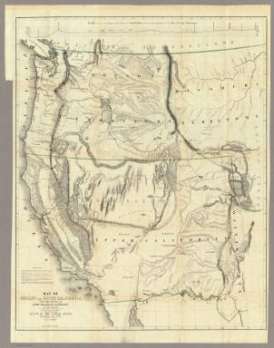
Full Title
Map Of An Exploring Expedition To The Rocky Mountains in the Year 1842, Oregon & North California In The Years 1843-44. By Brevet Capt. J. C. Fremont Of The Corps Of Topographical Engineers Under the orders of Col. J.J. Abert, Chief Of The Topographical Bureau. Lith. by E. Weber & Co. Baltimore, Md.
Publisher
Blair and Rives
Author
Fremont, J.C.
Full Title
(Title Page to) Geographical Memoir upon Upper California In Illustration of His Map of Oregon and California, by John Charles Fremont: Addressed to the Senate of the United States. Washington: Wendell and Van Benthuysen, Printers. 1848. [Senate.] 30th Congress, 1st Session. Miscellaneous. No. 148.
Publisher
Wendell and Van Benthuysen
Author
Fremont, J.C.
Full Title
Map Of Oregon And Upper California From the Surveys of John Charles Fremont And other Authorities. Drawn By Charles Preuss Under the Order of the Senate Of The United States, Washington City 1848. Lithy. by E. Weber & Co. Balto. (inset) Profile of the travelling route from the South Pass of the Rocky Mountains to the Bay of San Francisco.
Publisher
Wendell and Van Benthuysen
Author
Hayden, F.V.
Full Title
(Title Page to) Geological Report of the Exploration of the Yellowstone and Missouri Rivers by Dr. F.V. Hayden, Assistant, under the direction of Captain (now Lieut. Col. and Brevet Brig. Gen.) W.F. Raynolds, Corps of Engineers, 1859-'60. Washington: Government Printing Office. 1869.
Publisher
U.S.
Author
Hayden, F.V.
Full Title
U.S. War Department Map Of The Yellowstone And Missouri Rivers And Their Tributaries explored by Capt. W.F. Raynolds Topl. Engrs. and 1st Lieut. H.E. Maynadier 10th Infy. Assistant. 1859-60. To accompany a report to the Bureau of Topographical Engineers. Lt. Col. Harman Bache in charge. Engraved in the Engineer Bureau War Dept. Prepared to accompany the Geological Report of F.V. Hayden M.D. ... Printed by Julius Bien, N.Y.
Publisher
Government Printing Office
Author
Macomb, J.N.
Full Title
(Title Page to) Report of the Exploring Expedition From Santa Fe, New Mexico, To The Junction of the Grand and Green Rivers of the Great Colorado of the West, In 1859, Under the Command of Capt. J.N. Macomb, Corps of Topographical Engineers (Now Colonel of Engineers); With A Geological Report by Prof. J.S. Newberry, Geologist of the Expedition. Washington: Government Printing Office. 1876.
Publisher
Washington: U.S.
Author
[Macomb, J.N., Egloffstein, F.W.]
Full Title
Map of Exploration and Surveys in New Mexico and Utah made under the direction of the Secretary of War by Capt. J.N. Macomb Topl. Engrs. assisted by C.H. Dimmock, C. Engr. 1860. Lettering by John L. Hazzard. Ruling by Samuel Sartain. Constructed and Engraved by Baron F.W. Von Egloffstein.
Publisher
Washington: U.S.
Author
Mullan, John
Full Title
(Title Page to) Miners and Travelers' Guide to Oregon, Washington, Idaho, Montana, Wyoming, and Colorado. Via the Missouri and Columbia Rivers. Accompanied by a General Map of the Mineral Region of the Northern Sections of the Rocky Mountains. Prepared by Captain John Mullan ... New York: Published by Wm. M. Franklin, (for the author), 24 Vesey Street, 1865. (on verso) Entered ... 1865, by H. Stern ... New York.
Publisher
Wm. M. Franklin
Author
[Dutton, Clarence E. (Clarence Edward), 1841-1912, Geographical and Geological Survey of the Rocky Mountain Region (U.S.)]
Full Title
(covers to) Topographical and geological atlas of the district of the high plateaus of Utah to accompany the report of Capt. C.E. Dutton, U.S. Ordnance Corps, assistant geologist. Julius Bien, Lith., New York, 1879.
Publisher
U.S. Geographical and Geological Survey of the Rocky Mountain Region
Author
[Dutton, Clarence E. (Clarence Edward), 1841-1912, Geographical and Geological Survey of the Rocky Mountain Region (U.S.)]
Full Title
(Title Page to) Topographical and geological atlas of the district of the high plateaus of Utah to accompany the report of Capt. C.E. Dutton, U.S. Ordnance Corps, assistant geologist. Julius Bien, Lith., New York, 1879.
Publisher
U.S. Geographical and Geological Survey of the Rocky Mountain Region
Author
[Geographical and Geological Survey of the Rocky Mountain Region (U.S.), Graves, W. H., Renshawe, J. H. (John Henry), 1852-, Thompson, A. H. (Almon Harris), 1839-1906]
Full Title
Map of the district of the High Plateaus of Utah. Triangulation by A.H. Thompson, topographers J.H. Renshawe, W.H. Graves. Dept. of the Interior, U.S. G. and G. Survey, J.W. Powell in charge. Atlas sheet no. 1, Geology of the high plateaus of Utah by Capt. C.E. Dutton, U.S.A. (Julius Bien, Lith., New York, 1879)
Publisher
U.S. Geographical and Geological Survey of the Rocky Mountain Region
Author
[Dutton, Clarence E. (Clarence Edward), 1841-1912, Geographical and Geological Survey of the Rocky Mountain Region (U.S.), Graves, W. H., Renshawe, J. H. (John Henry), 1852-, Thompson, A. H. (Almon Harris), 1839-1906]
Full Title
Geological map of the district of the high plateaus of Utah. Triangulation by A.H. Thompson, topographers J.H. Renshawe, W.H. Graves. Geology by Capt. C.E. Dutton, U.S.A. Dept. of the Interior, U.S. G. and G. Survey, J.W. Powell in charge. Atlas sheet no. 2, Geology of the high plateaus of Utah by Capt. C.E. Dutton, U.S.A. (Julius Bien, Lith., New York, 1879)
Publisher
U.S. Geographical and Geological Survey of the Rocky Mountain Region
Author
[Dutton, Clarence E. (Clarence Edward), 1841-1912, Geographical and Geological Survey of the Rocky Mountain Region (U.S.)]
Full Title
Relief map of the district of the high plateaus of Utah. Dept. of the Interior, U.S. G. and G. Survey, J.W. Powell in charge. Atlas sheet no. 3, Geology of the high plateaus of Utah by Capt. C.E. Dutton, U.S.A. (Julius Bien, Lith., New York, 1879)
Publisher
U.S. Geographical and Geological Survey of the Rocky Mountain Region
Author
[Dutton, Clarence E. (Clarence Edward), 1841-1912, Geographical and Geological Survey of the Rocky Mountain Region (U.S.)]
Full Title
Map of portions of Utah and Arizona showing the arrangement of faults and flexures in the Kaibabs and high plateaus. Dept. of the Interior, U.S. G. and G. Survey, J.W. Powell in charge. Atlas sheet no. 4, Geology of the high plateaus of Utah by Capt. C.E. Dutton, U.S.A. (Julius Bien, Lith., New York, 1879)
Publisher
U.S. Geographical and Geological Survey of the Rocky Mountain Region
Author
[Dutton, Clarence E. (Clarence Edward), 1841-1912, Geographical and Geological Survey of the Rocky Mountain Region (U.S.)]
Full Title
Stereogram of displacements in the district of the high plateaus of Utah. Showing the vertical displacements of a given horizon since the close of the Green River epoch, with the supposition that there had been no erosion. By C.E. Dutton, Capt. of Ordnance, U.S.A. Dept. of the Interior, U.S. G. and G. Survey, J.W. Powell in charge. Atlas sheet no. 5, Geology of the high plateaus of Utah by Capt. C.E. Dutton, U.S.A. (Julius Bien, Lith., New York, 1879)
Publisher
U.S. Geographical and Geological Survey of the Rocky Mountain Region
Author
[Dutton, Clarence E. (Clarence Edward), 1841-1912, Geographical and Geological Survey of the Rocky Mountain Region (U.S.)]
Full Title
Structure sections through the high plateaus. Dept. of the Interior, U.S. G. and G. Survey, J.W. Powell in charge. Atlas sheet no. 6, Geology of the high plateaus of Utah by Capt. C.E. Dutton, U.S.A. (Julius Bien, Lith., New York, 1879)
Publisher
U.S. Geographical and Geological Survey of the Rocky Mountain Region
Author
[Dutton, Clarence E. (Clarence Edward), 1841-1912, Geographical and Geological Survey of the Rocky Mountain Region (U.S.)]
Full Title
Structure sections through the high plateaus. Dept. of the Interior, U.S. G. and G. Survey, J.W. Powell in charge. Atlas sheet no. 7, Geology of the high plateaus of Utah by Capt. C.E. Dutton, U.S.A. (Julius Bien, Lith., New York, 1879)
Publisher
U.S. Geographical and Geological Survey of the Rocky Mountain Region
Author
[Dutton, Clarence E. (Clarence Edward), 1841-1912, Geographical and Geological Survey of the Rocky Mountain Region (U.S.), Graves, W. H., Lindenkohl, H. (Henry), Mahon, Charles]
Full Title
Map of Utah Territory compiled and drawn by Charles Mahon, J.H. Renshawe, W.H. Graves and H. Lindenkohl. Dept. of the Interior, U.S. G. and G. Survey, J.W. Powell in charge. Atlas sheet no. 8, Geology of the high plateaus of Utah by Capt. C.E. Dutton, U.S.A. (Julius Bien, Lith., New York, 1879)
Publisher
U.S. Geographical and Geological Survey of the Rocky Mountain Region
Author
Mullan, John
Full Title
General Map of the North Pacific States and Territories Belonging to the United States and of British Columbia, Extending from Lake Superior to the Pacific Ocean and Between Latitude 39 degrees and 53 degrees North. Exhibiting Mail Routes, Gold Mines, and Including the Most Recent Surveys of the Topographical Bureau. Prepared by Captain John Mullan. ... Drawn by Edward Freyhold, T.E. Lithographed by J. Bien, 24 Vesey, St. N.Y.
Publisher
Wm. M. Franklin
Author
Nicollet, J. N. (Joseph Nicolas), 1786-1843
Full Title
(Title Page to) Report Intended To Illustrate A Map Of The Hydrographical Basin of the Upper Mississippi River, Made by I.N. Nicollet ... February 16, 1841. Washington: Blair and Rives, Printers. 1843. [Senate.] 26th Congress, 2d Session. [237].
Publisher
Blair and Rives
Author
Nicollet, J. N. (Joseph Nicolas), 1786-1843
Full Title
Hydrographical Basin of the Upper Mississippi River From Astronomical and Barometrical Observations Surveys and Information by J.N. Nicollet ... assisted ... by Lieut. J.C. Fremont ... Reduced and compiled under the direction of Col. J.J. Abert in the Bureau of the Corps of Topl. Engrs. by Lieut. W.H. Emory ... 1843 ... W.J. Stone Sc.
Publisher
Blair and Rives
Author
[Colton, J. H., Warren, Gouverneur Kemble, 1830-1882, Redpath, James, Hinton, Richard J]
Full Title
(Covers to) Hand Book To Kansas Territory And The Rocky Mountains' Gold Region; Accompanied By Reliable Maps and a Preliminary Treatise on the Pre-emption Laws of the United States. By James Redpath and Richard J. Hinton, of Kansas. New York: J.H. Colton, Publisher, 172 William Street. 1859. (on verso) Entered ... in the year 1859, (Published) by J.H. Colton ... New York.
Publisher
J. H. Colton.
Author
[Colton, J. H., Warren, Gouverneur Kemble, 1830-1882, Redpath, James, Hinton, Richard J]
Full Title
Catalog) Hand Book To Kansas Territory And The Rocky Mountains' Gold Region; Accompanied By Reliable Maps and a Preliminary Treatise on the Pre-emption Laws of the United States. By James Redpath and Richard J. Hinton, of Kansas. New York: J.H. Colton, Publisher, 172 William Street. 1859. (on verso) Entered ... in the year 1859, (Published) by J.H. Colton ... New York.
Publisher
J. H. Colton.
|