Who What Where WhenREMOVE |
Author
Imlay, Gilbert
Full Title
A Map of The Western Part of the Territories belonging to the United States of America. Drawn from the best Authorities. Engraved for Imlay's Topographical Description of that Country. T. Conder Sculpt. Published June 1st 1795, by J. Debrett, Picadilly, London.
Publisher
J. Debrett
Author
Imlay, Gilbert
Full Title
A Plan of the Rapids of the Ohio. T. Conder, Sculpt. Engraved for Imlay's American Topography. Published Feby. 1st, 1793, by J. Debrett, Piccadilly, London.
Publisher
J. Debrett
Author
Imlay, Gilbert
Full Title
A Map of the State of Kentucky, from Actual Survey by Elihu Barker of Philadelphia. T. Conder Sculpt. London, Published June 1st, 1795 by J. Debrett, PIccadilly.
Publisher
J. Debrett
Author
Imlay, Gilbert
Full Title
A Map of the Tennassee Government, formerly part of North Carolina, taken chiefly from Surveys by Genel. D. Smith & others. T. Conder Sculpt. Engraved for Imlay's American Topography. London, Published June 1st, 1795, by J. Debrett, Piccadilly.
Publisher
J. Debrett
Author
Gallatin, Albert
Full Title
(Title Page to) A Synopsis of the Indian Tribes Within the United States East of the Rocky Mountains, and in the British and Russian Possessions in North America. By the Hon. Albert Gallatin. (In: Archaeologia Americana. Transactions and Collections of the American Antiquarian Society. Vol II. Cambridge: Printed For The Society, At The University Press. 1836).
Publisher
The University Press
Author
Gallatin, Albert
Full Title
Map of the Indian Tribes of North America about 1600 A.D. along the Atlantic; & about 1800 A.D. westwardly. Published by the Amer: Antiq: Soc: From a drawing by Hon: A. Gallatin.
Publisher
The University Press
Author
[Allen, Paul, Biddle, Nicholas, Clark, William, Lewis, Meriwether]
Full Title
(Title Page to) History Of The Expedition Under The Command Of Captains Lewis And Clark, To The Sources Of The Missouri, Thence Across The Rocky Mountains And Down The River Columbia To The Pacific Ocean. Performed During The Years 1804-5-6. By order of the Government Of The United States. Prepared For The Press By Paul Allen, Esquire. In Two Volumes. Vol. I. Philadelphia: Published By Bradford And Inskeep, New York. J. Maxwell, Printer. 1814 ... Vol. II.
Publisher
Bradford and Inskeep
Author
[Allen, Paul, Biddle, Nicholas, Clark, William, Lewis, Meriwether]
Full Title
A Map of Lewis and Clark's Track, Across the Western Portion of North America From the Mississippi to the Pacific Ocean; By Order of the Executive of the United States, in 1804, 5 & 6. Copied by Samuel Lewis from the Original Drawing of Wm. Clark. Smal. Harrison fct.
Publisher
Bradford and Inskeep
Author
[Allen, Paul, Biddle, Nicholas, Clark, William, Lewis, Meriwether]
Full Title
Fortification.
Publisher
Bradford and Inskeep
Author
[Allen, Paul, Biddle, Nicholas, Clark, William, Lewis, Meriwether]
Full Title
The Falls and Portage.
Publisher
Bradford and Inskeep
Author
[Allen, Paul, Biddle, Nicholas, Clark, William, Lewis, Meriwether]
Full Title
Great Falls of Columbia River.
Publisher
Bradford and Inskeep
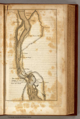
Author
[Allen, Paul, Biddle, Nicholas, Clark, William, Lewis, Meriwether]
Full Title
The Great Shoot or Rapid.
Publisher
Bradford and Inskeep
|