Who What Where WhenREMOVEWHEREShow More |
Author
Caldwell, Joseph A.
Full Title
Economy. (to accompany) Caldwell's Illustrated, Historical, Centennial Atlas Of Beaver County, Pennsylvania. From actual Surveys by & under the directions of J.A. Caldwell. Assisted by C.T. Arms, Sr. C.E. J.A. Underwood, C.E. J.A. Howden. P.L. Mason. W.J. Kerstetter, C.E. W.F. Arms, C.E. J.J. Power, C.E. Published By J.A. Caldwell, Condit, Ohio. 1876. Engraved, Lithographed & Printed By Otto Krebs, Pittsburgh, Pa.
Publisher
J.A. Caldwell
Author
Caldwell, Joseph A.
Full Title
New Gallilee In Big Beaver Twp. (inset) Hanover, Hanover Twp. (to accompany) Caldwell's Illustrated, Historical, Centennial Atlas Of Beaver County, Pennsylvania. From actual Surveys by & under the directions of J.A. Caldwell. Assisted by C.T. Arms, Sr. C.E. J.A. Underwood, C.E. J.A. Howden. P.L. Mason. W.J. Kerstetter, C.E. W.F. Arms, C.E. J.J. Power, C.E. Published By J.A. Caldwell, Condit, Ohio. 1876. Engraved, Lithographed & Printed By Otto Krebs, Pittsburgh, Pa.
Publisher
J.A. Caldwell
Author
Caldwell, Joseph A.
Full Title
Industry. (with) Pulaski (to accompany) Caldwell's Illustrated, Historical, Centennial Atlas Of Beaver County, Pennsylvania. From actual Surveys by & under the directions of J.A. Caldwell. Assisted by C.T. Arms, Sr. C.E. J.A. Underwood, C.E. J.A. Howden. P.L. Mason. W.J. Kerstetter, C.E. W.F. Arms, C.E. J.J. Power, C.E. Published By J.A. Caldwell, Condit, Ohio. 1876. Engraved, Lithographed & Printed By Otto Krebs, Pittsburgh, Pa.
Publisher
J.A. Caldwell
Author
Caldwell, Joseph A.
Full Title
Rochester. (inset) Ohioville. Ohio Twp. Scale 300 feet to the inch. (to accompany) Caldwell's Illustrated, Historical, Centennial Atlas Of Beaver County, Pennsylvania. From actual Surveys by & under the directions of J.A. Caldwell. Assisted by C.T. Arms, Sr. C.E. J.A. Underwood, C.E. J.A. Howden. P.L. Mason. W.J. Kerstetter, C.E. W.F. Arms, C.E. J.J. Power, C.E. Published By J.A. Caldwell, Condit, Ohio. 1876. Engraved, Lithographed & Printed By Otto Krebs, Pittsburgh, Pa.
Publisher
J.A. Caldwell
Author
Caldwell, Joseph A.
Full Title
Green(e). (to accompany) Caldwell's Illustrated, Historical, Centennial Atlas Of Beaver County, Pennsylvania. From actual Surveys by & under the directions of J.A. Caldwell. Assisted by C.T. Arms, Sr. C.E. J.A. Underwood, C.E. J.A. Howden. P.L. Mason. W.J. Kerstetter, C.E. W.F. Arms, C.E. J.J. Power, C.E. Published By J.A. Caldwell, Condit, Ohio. 1876. Engraved, Lithographed & Printed By Otto Krebs, Pittsburgh, Pa.
Publisher
J.A. Caldwell
Author
Caldwell, Joseph A.
Full Title
Franklin. (inset) Clinton. (to accompany) Caldwell's Illustrated, Historical, Centennial Atlas Of Beaver County, Pennsylvania. From actual Surveys by & under the directions of J.A. Caldwell. Assisted by C.T. Arms, Sr. C.E. J.A. Underwood, C.E. J.A. Howden. P.L. Mason. W.J. Kerstetter, C.E. W.F. Arms, C.E. J.J. Power, C.E. Published By J.A. Caldwell, Condit, Ohio. 1876. Engraved, Lithographed & Printed By Otto Krebs, Pittsburgh, Pa.
Publisher
J.A. Caldwell
Author
[Götz, Antonín, Československá akademie věd., Czechoslovakia. Ústřední správa geodézie a kartografie.]
Full Title
Housing Conditions.
Publisher
Czechoslovakia. Ústřední správa geodézie a kartografie.
Author
Straus Brothers Company
Full Title
(Covers to) (Central States farm locations.) The Straus Bros. Co. The World's Largest Dealers in Improved Farms. ... (title on cover) Central States Map Showing location of the sections in which more than Four Hundred of the choicest and most productive farms in America are offered for sale by The Straus Brothers Company, Farm Merchants, Capital $1,000,000...Write For Catalogue.
Publisher
The Straus Brothers Company
Author
Straus Brothers Company
Full Title
(Central States farm locations.) The Straus Bros. Co. The World's Largest Dealers in Improved Farms. ... (title on cover) Central States Map Showing location of the sections in which more than Four Hundred of the choicest and most productive farms in America are offered for sale by The Straus Brothers Company, Farm Merchants, Capital $1,000,000...Write For Catalogue.
Publisher
The Straus Brothers Company
Author
Amerine, C.H.
Full Title
C.H. Amerine's : Sectional map of Washington, Oregon, Idaho, and western Montana. Compiled from latest official data exploration and other sources. Compiled and published by C.H. Amerine, 1891. Copyrighted by C.H. Amerine, Tacoma, Wash. Photo - Litho by Schmidt Lable & Lith Co. S.F.
Publisher
[C.H.Amerine, Schmidt Lable & Lith Co.]
Author
Powell, John Wesley, 1834-1902.
Full Title
Map of the United States exhibiting the grants of lands made by the general government to aid in the construction of railroads and wagon roads. For explanation see chapter on "L̀and grants in aid of internal improvements". Julius Bien, Lithographer. (at head of title) Department of the Interior, U.S. Geographical and Geological Survey of the Rocky Mountain region, J.W. Powell in charge. (on upper margin) To accompany report on the Lands of the Arid Region of the U.S.
Publisher
Government Printing Office
Author
Powell, John Wesley, 1834-1902.
Full Title
Rain chart of the United States : showing by isohyetal lines the distribution of the mean annual precipitation in rain and melted snow. This is a copy of the chart constructed for the Smithsonian Institution in 1868 by Charles A Schott ... Julius Bien, Lithographer. (at head of title) Department of the Interior, U.S. Geographical and Geological Survey of the Rocky Mountain region, J.W. Powell in charge. (on upper margin) To accompany report on the Lands of the Arid Region of the U.S.
Publisher
Government Printing Office
Author
[Bennett, Edward H., Burnham, Daniel Hudson]
Full Title
(Covers to) Report on a plan for San Francisco by Daniel H. Burnham. Assisted by Edward H. Bennett. Presented to the Mayor and Board of Supervisors by the Association for the Improvement and Adornment of San Francisco. Edited by Edward F. O'Day. September, MCMV. Published by the City.
Publisher
City of San Francisco
Author
[Bennett, Edward H., Burnham, Daniel Hudson]
Full Title
(Title Page to) Report on a plan for San Francisco by Daniel H. Burnham. Assisted by Edward H. Bennett. Presented to the Mayor and Board of Supervisors by the Association for the Improvement and Adornment of San Francisco. Edited by Edward F. O'Day. September, MCMV. Published by the City. (verso: engraved and printed by Sunset Press, San Francisco)
Publisher
City of San Francisco
Author
[Bennett, Edward H., Burnham, Daniel Hudson]
Full Title
(Contents to) Report on a plan for San Francisco by Daniel H. Burnham. Assisted by Edward H. Bennett. Presented to the Mayor and Board of Supervisors by the Association for the Improvement and Adornment of San Francisco. Edited by Edward F. O'Day. September, MCMV. Published by the City.
Publisher
City of San Francisco
Author
[Bennett, Edward H., Burnham, Daniel Hudson, Meryon, Charles]
Full Title
(Preface to) Report on a plan for San Francisco by Daniel H. Burnham. Assisted by Edward H. Bennett. Presented to the Mayor and Board of Supervisors by the Association for the Improvement and Adornment of San Francisco. Edited by Edward F. O'Day. September, MCMV. Published by the City.
Publisher
City of San Francisco
Author
[Bennett, Edward H., Burnham, Daniel Hudson]
Full Title
(Preface to) Report on a plan for San Francisco by Daniel H. Burnham. Assisted by Edward H. Bennett. Presented to the Mayor and Board of Supervisors by the Association for the Improvement and Adornment of San Francisco. Edited by Edward F. O'Day. September, MCMV. Published by the City.
Publisher
City of San Francisco
Full Title
Bird's-eye perspective of the City from Twin Peaks, showing the proposed changes. (By Daniel H. Burnham. Assisted by Edward H. Bennett. 1905)
Publisher
City of San Francisco
Full Title
Bird's-eye perspective of the City from the east, showing the proposed changes. (By Daniel H. Burnham. Assisted by Edward H. Bennett. 1905)
Publisher
City of San Francisco
Full Title
Plan of Civic Center. (By Daniel H. Burnham. Assisted by Edward H. Bennett. 1905)
Publisher
City of San Francisco
Full Title
View of Civic Center, looking from the south side of Market Street. (By Daniel H. Burnham. Assisted by Edward H. Bennett. 1905)
Publisher
City of San Francisco
Full Title
Typical plan of playground north of Washington Square. (By Daniel H. Burnham. Assisted by Edward H. Bennett. 1905)
Publisher
City of San Francisco
Full Title
Telegraph Hill, looking east, showing suggested architectural treatment. (By Daniel H. Burnham. Assisted by Edward H. Bennett. 1905)
Publisher
City of San Francisco
Full Title
View of the proposed drill ground from the heights, looking northeast (San Francisco Presidio. By Daniel H. Burnham. Assisted by Edward H. Bennett. 1905)
Publisher
City of San Francisco
Full Title
Approach to Twin Peaks as seen from Market Street. (By Daniel H. Burnham. Assisted by Edward H. Bennett. 1905)
Publisher
City of San Francisco
Author
Burnham, Daniel Hudson
Full Title
Map of the city and county of San Francisco showing areas recommended as necessary for public places, parks, park connections and highways. Report of D.H. Burnham, Sept. 1905.
Publisher
City of San Francisco
Author
Burnham, Daniel Hudson
Full Title
San Francisco plan, showing system of highways, public places, parks, park connections, etc. to serve as a guide for the future development of the city recommended in his Report to the Association for the Improvement and Adornment of San Francisco by D.H. Burnham. September MCMV.
Publisher
City of San Francisco
Author
Burnham, Daniel Hudson
Full Title
Map showing San Francisco wate-front in early days.
Publisher
City of San Francisco
Author
Burnham, Daniel Hudson
Full Title
Mission Plank Road, Southwest fron Ninth, 1856
Publisher
City of San Francisco
Author
Allardt, G. F.
Full Title
Map no. 3. Salt marsh and tide lands situate in the city and county of San Francisco. To be sold at public auction by order of the Board of Tide Land Commissioners by Talbert & Leet, auctioneers, at their sales rooms no. 526 California Street, San Francisco. Sale to commence Friday Nov. 26th, 1869. B.F. Washington, H.P. Coon, L.L Bullock, Wm. S. Byrne, Secretary, Tide Land Commissioners. G.F. Allardt, Surveyor & Chief Engineer. C.H. Baker Lith., S.F.
Publisher
G.H. Baker, Lith.
Author
Allardt, G. F.
Full Title
Sale map no. 12. Salt marsh and tide lands situate in the city and county of San Francisco, state of California. To be sold at public auction by order of the Board of Tide Land Commissioners ... at the sales rooms of Greenebaum & Co., auctioneers, nos. 115 & 117 Bush Street, San Francisco. Sale to commence Tuesday, March 4th, 1873. R.P. Johnson, Edgar Briggs, C.M. Stratton, Board of Tide Land Commissioners. J.M. Currier, Secretary. G.F. Allardt, Chief Engineer.
Publisher
No Publisher
Author
Allardt, G. F.
Full Title
Sale map no. 8 of salt marsh and tide lands situate in the county of Marin, state of California. To be sold at public auction by order of the Board of Tide Land Commissioners ... John Middleton, auctioneer. Sale to commence Tuesday, July 18th 1871 at Platt's Hall, San Francisco. B.F. Washington, Rodmond Gibbons, L.L. Bullock, Board of Tide Land Commissioners. Wm. S. Byrne, Secretary. G.F. Allardt, Chief Engineer. F.C. Hafenrichter, draughtsman. G.T. Brown & Co. Lith. 540 Clay St. S.F.
Publisher
G.T. Brown & Co. Lith.
Author
[Britton & Co., Hoadley, Milo]
Full Title
Map of the Beideman Tract lots & blocks according to official map of the Western Addition. Drawn from actual survey by M. Hoadley. ... Lith. Britton & Co. To be sold at public auction, on Saturday, Oct. 6th, 1860 at 12 o'clock M. at Platts Music Hall. By H.A. Cobb and R.H. Sinton, real estate auctrs. (with) Map of the city of San Francisco. Published by Britton & Co., Lithographers, Montgomery St. cor. of Comml. sts., San Francisco.
Publisher
Britton & Co.
Full Title
377. True value of real and personal property per capita: 1890. 381. True valuation of real estate and improvements thereon per acre: 1890. Julius Bien & Co. Lith., N.Y. (1898)
Publisher
U.S. Census Office
Full Title
382. True valuation of real estate and improvements thereon per capita: 1890. 383. Assessed valuation of real and personal property per capita: 1890. Julius Bien & Co. Lith., N.Y. (1898)
Publisher
U.S. Census Office
Author
[Los Angeles & Santa Monica Land & Water Co., Theo. G. Kocher & Co.]
Full Title
Map of the subdivision of Rancho San Jose de Buenos Ayres and the town of Sunset owned by Los Angeles & Santa Monica Land & Water Co., situated in Los Angeles Co., Cal. Surveyed by Theo. G. Kocher & Co. 1887. Los Angeles Litho. Co., 48 to 52 Banning St.
Publisher
Los Angeles & Santa Monica Land & Water Co
Author
[McClure, W. F. (Wilbur F.), Patterson, Smith & Co.]
Full Title
Map of Berkeley, California. W.F. McClure, City Engineer. Patterson, Smith & Co., Inc., successors to R.R. Patterson, Real Estate and Insurance, 2107 University Avenue ... General agents for Claremont Heights Tract. (1910?)
Publisher
Patterson, Smith & Co.
Author
[McClure, W. F. (Wilbur F.), Patterson, Smith & Co.]
Full Title
Claremont Heights Subdivision No. 1. Choice Berkeley villa sites. W.F. McClure, City Engineer of Berkeley. Patterson, Smith & Co., Inc., 2107 University Avenue, Berkeley, Cal. (1910?)
Publisher
Patterson, Smith & Co.
Author
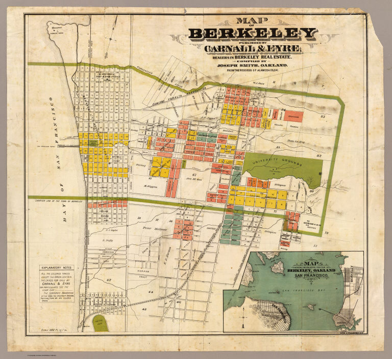
Smith, Joseph, draftsman
Full Title
Map of Berkeley. Published by Carnall & Eyre, dealers in Berkeley Real Estate. Compiled by Joseph Smith, Oakland. From the records of Alameda Co., Cal. Lith. A. Waldstein, S.F. (1880)
Publisher
Carnall & Eyre
Author
[King, M. G. (Malcolm G.), William J. Dingee]
Full Title
W.F. Melvin, E.F. Vandercook, R.D. Jackson. Jackson, Vandercook & Melvin, successors to C.W. McLaughlin & Co. Real estate and insurance agents, 458 Ninth Street. Telephone No. 285. Oakland, Cal. (1884?)
Publisher
William J. Dingee.
Author
[King, M. G. (Malcolm G.), William J. Dingee]
Full Title
Map of Oakland, Berkeley and Alameda. William J. Dingee, agent. For the purchase, sale, appraisal and care of real estate. 460 & 462 Eighth Street near Broadway, Oakland. M.G. King, C.E., surveyor. Entered ... in the year 1878, by Woodward & Taggart in the office of the Librarian of Congress at Washington, D.C. Galloway Litho Co., 418-422 Commercial St., S.F. (1884?)
Publisher
William J. Dingee.
Author
Great Northern Railway Company (U.S.)
Full Title
Great Northern Railway line and connections. (with:) Karte des Red River Thales in vergrossertem Masstabe. Knight, Leonard & Co., engr's., Chi(cago)
Publisher
Great Northern Eisenbahn
Author
Great Northern Railway Company (U.S.)
Full Title
(Covers to) Das Red River Thal in Minnesota und Nord-Dakota. Das beste und fruchtbarste Land in America. Die Getreidekammer der Welt. Ein gutes Heim und Reichthum fur Deutsche Landwirthe.
Publisher
Great Northern Eisenbahn
Author
Great Northern Railway Company (U.S.)
Full Title
(Text Page to) Das Red River Thal in Minnesota und Nord-Dakota. Das beste und fruchtbarste Land in America. Die Getreidekammer der Welt. Ein gutes Heim und Reichthum fur Deutsche Landwirthe.
Publisher
Great Northern Eisenbahn
Author
St. Louis-San Francisco Railway Company
Full Title
(Text Page to) St. Louis and San Francisco Railway befordert Fracht und Passagiere zu den billigsten Preisen! nach allen Punkten in Sud-West Missouri, dem Sudlichen Kansas und Texas ... Woodward, Tiernan & Hale, Printers, St. Louis.
Publisher
Woodward, Tiernan & Hale
Author
St. Paul, Minneapolis & Manitoba Railway Company.
Full Title
St. Paul. Minneapolis & Manitoba Railway. Commences at St. Paul, Minneapolis and Duluth, and runs northwest through the timbered districts of Minnesota to the Red River Valley ... Engraved by American Bank Note Co., N.Y. This map corrected according to government surveys, January 1, 1885. (inset) Map of the St. Paul, Minneapolis & Manitoba Railway, and connections.
Publisher
Matthews, Northrup & Co.
Author
Northern Pacific Railroad Company
Full Title
Map showing surveyed portion of land grant of Northern Pacific Railroad Company from Jamestown, North Dakota, to Montana boundary line ... (1895)
Publisher
The Evening Wisconsin Co.
Author
Northern Pacific Railroad Company
Full Title
(Covers to) Map showing surveyed portion of land grant of Northern Pacific Railroad Company from Jamestown, North Dakota, to Montana boundary line ... (1895)
Publisher
The Evening Wisconsin Co.
Author
Northern Pacific Railroad Company
Full Title
(Text Page to) Map showing surveyed portion of land grant of Northern Pacific Railroad Company from Jamestown, North Dakota, to Montana boundary line ... (1895)
Publisher
The Evening Wisconsin Co.
|