Browse All

1882 Map of Dakota. Separate Map Map of Dakota. Drawn From Official Plats … |

1868 Map Of The Outside Lands Of The City And … Separate Map Map Of The Outside Lands Of The City And … |

1868 Map Of The Outside Lands Of The City And … Separate Map Map Of The Outside Lands Of The City And … |

1855 Map Of The Town Of Clinton Separate Map Map Of The Town Of Clinton, Clinton Coun … |

1864 Railroad Map Of Illinois Pocket Map Railroad Map Of Illinois. One Million Ac … |

1919 Map of Pacific Grove Properties Separate Map Map of Pacific Grove Properties Showing … |

1919 Text Page: Map of Pacific Grove Properti … Separate Map (Text Page to) Map of Pacific Grove Prop … |

1919 Text Page: Map of Pacific Grove Properti … Separate Map (Text Page to) Map of Pacific Grove Prop … |

1888 Covers:Park Place, Formerly Known As Lau … Real Estate (Covers to) Second grand excursion to, a … |

1888 Park Place, Formerly Known As Laundry Fa … Real Estate Relative Position of Park Place, Laundry … |

1888 Park Place, Formerly Known As Laundry Fa … Real Estate Map showing A Portion Of Park Place, For … |

1887 Covers: Roberts and Wolfskill Tract Real Estate (Covers to) Free carriage to and from th … |

1887 Advertisement: Roberts and Wolfskill Tra … Real Estate (Advertisement to) ) Roberts & Wolfskill … |

1887 Roberts and Wolfskill Tract Real Estate Roberts & Wolfskill Tract. The Roberts A … |

1887 Roberts and Wolfskill Tract Real Estate (Untitled map of) Roberts & Wolfskill Tr … |

1832 Map Of The Town Of Ipswich, County Of Es … Separate Map Map Of The Town Of Ipswich, County Of Es … |

1830 Map Of North-Brookfield Separate Map Map Of North-Brookfield. From Actual Sur … |

1901 Map Of North Dakota Separate Map Map of North Dakota. Great Opportunities … |

1896 Map of the Peninsula of Florida and Adja … Separate Map Map of the Peninsula of Florida and Adja … |

1856 Central Bluffs, Burt County, Nebraska Separate Map Central Bluffs, Burt County, Nebraska. A … |
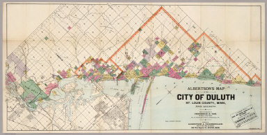
1891 Map Of The City Of Duluth, St. Louis Cou … Separate Map Albertson's Map Of The City Of Duluth, S … |

1873 Plan Of Lagoon Heights, Martha's Vineyar … Separate Map Plan Of Lagoon Heights, Martha's Vineyar … |

1910 Map of Richmond, California Separate Map Map of Richmond, California. New Richmon … |

1900 The Cadillac Tract Separate Map The Cadillac Tract: Is shown by the desc … |

1875 Settlement of Vineland Cumberland County … Separate Map Settlement of Vineland Cumberland Co. N. … |

1964 Rapid Growth State Atlas 21. Rapid Growth. (to accompany) Atlas o … |

1964 Text Page: Land Use State Atlas (Text Page to) 22. Land Use. Sources: U. … |

1878 Cover: Texas & Pacific Railway. Timetable Map (Covers to:) The Texas and Pacific Railw … |

1878 Texas & Pacific Railway. Timetable Map The Texas and Pacific Railway. The short … |

1878 State Of Texas. Timetable Map A geographically correct map of the stat … |

1887 Pleasant Valley Tract, Oroville. Separate Map Map of the Pleasant Valley Tract at Orov … |

1887 View, Pleasant Valley Tract. Separate Map View of Pleasant Valley Tract and City o … |

1891 North Galveston. Separate Map Map of North Galveston, Texas. North Gal … |

1891 Honey Lake Valley. Separate Map Plate No.4 showing reservoir, canals and … |

1876 Cover: State of Texas. Pocket Map (Covers to:) Map of the state of Texas. … |

1876 Verso: State of Texas. Pocket Map (Verso of:) Map of the state of Texas. W … |

1890 South San Francisco. Separate Map South San Francisco Issued By The South … |

1876 State Of Texas. Pocket Map Map of the state of Texas. Woodward, Tie … |

1878 Cover: The Lone Star guide. Pamphlet (Covers to:) The Lone Star guide descrip … |

1878 Intl. & Gt. N. Railroad. Pamphlet Map of the International and Great North … |

1891 Bird's eye view, Honey Lake Valley. Separate Map Bird's eye view of Honey Lake Valley. La … |

1912 Murray Tract Subdivision One, Marin Coun … Separate Map Map Of The Murray Tract Subdivision One, … |

1898 Rancho Cotati. County Atlas El Rancho Cotati, Sonoma Co., Cal. (Publ … |

1876 Map of the Borough of Philipsburg. Moon … County Atlas Map of the Borough of Phillipsburg. Moon … |

1876 Big Beaver Township, Beaver County, PA. County Atlas Big Beaver. (to accompany) Caldwell's Il … |

1876 Map of New Brighton. Beaver Co. PA. County Atlas Map of New Brighton. Beaver Co. PA. (to … |

1876 Hopewell Township, Beaver County, PA. County Atlas Hopewell. (insets) New Scottsville. Hope … |

1876 Marion Township ; Industry Township, Bea … County Atlas Marion ; Industry, Industry Twp. (to acc … |

1876 Moon Township, Beaver Co. PA. County Atlas Moon. (to accompany) Caldwell's Illustra … |

1876 Raccoon Township, Beaver Co. PA. County Atlas Raccoon. (to accompany) Caldwell's Illus … |