Who What Where WhenREMOVE |
Author
[Manning, F.E., Army Orientation Course, Special Service Division Army Service Forces]
Full Title
Newsmap. Monday, October 18, 1943. ... Vol. II No. 26. Roads to Rome. Southwest Pacific. Wake island. (World).
Publisher
Special Service Division Army Service Forces, War Department
Author
[Manning, F.E., Army Orientation Course, Special Service Division Army Service Forces]
Full Title
Target Berlin. Newsmap. Monday, October 25, 1943. ... Vol. II No. 27. Prepared and Distributed by the Army Orientation Course. Special Service Division Army Service Forces, War Dept.,2E581 Pentagon Bldg., Washington D.C. U.S. Government Printing Office: 1943 - 538110.
Publisher
Special Service Division Army Service Forces, War Department
Author
[Manning, F.E., Army Orientation Course, Special Service Division Army Service Forces]
Full Title
Newsmap. Monday, October 25, 1943. ... Vol. II No. 27. Bridgeheads across the Dnepr River. Operations in Burma. New Guinea. (Italy-Greece-Turkey).
Publisher
Special Service Division Army Service Forces, War Department
Author
Petersen, C.C.
Full Title
Your Dated War Map. Dated Events War Map.
Publisher
Shaw-Barton
Author
Alcoa Map Department, Aluminum Company of America
Full Title
Global Map for Global War and Global Peace.
Publisher
Aluminum Company of America (Alcoa)
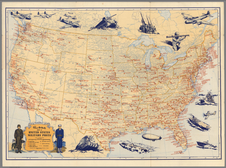
Author
Rand McNally & Co.
Full Title
Rand McNally Map of United States Military Posts.
Publisher
Rand McNally & Co.
Author
Toronto Star
Full Title
Star Weekly Map of the Axis Encirclement. January 9, 1943.
Publisher
Toronto Star
Author
Burke, Howard
Full Title
Two ways to reach Japan - One may take a decade. Los Angels Examiner ... Monday January 11, 1943. 22 Section 1. Howard Burke. (inset) Kusaie.
Publisher
Los Angeles Examiner
Author
Burke, Howard
Full Title
The Pacific - Vital area for United States and Japan. Los Angels Examiner ... November 1942. Howard Burke. (inset) Palau Islands.
Publisher
Los Angeles Examiner
Author
Los Angeles Times
Full Title
Saipan conquest sets pattern for vast aerial operations. Los Angeles Times. Monday July 10, 1944.
Publisher
Los Angeles Times
Author
Pacific Stars and Stripes
Full Title
Pacific Stars and Stripes Map of the (Korean) War. (inset) 38th Parallel.
Publisher
Pacific Stars and Stripes
Author
[Margedant, William, Powell, W. Angelo, Raynolds, William F., United States. War Department]
Full Title
Military reconnaissance, vicinity of Gauley Bridge, Department of Western Virginia, Brig. Gen. W.S. Rosecrans, Commanding, by W.F. Raynolds, Capt. Top. Engrs., W. Margedant, Capt. O.V. and W. Angelo Powell, C. Engr. (with) Map of the battle-field of Carnifix Ferry, Gauley River, West Va. September 10th, 1861. United States forces commanded by Brig. Genl. W.S. Rosecrans. (with) Sketch of the country about Somerset, Ky. Julius Bien & Co., Lith., N.Y. (1891-1895)
Publisher
U.S. Government Printing Office
Author
United States. War Department
Full Title
Map showing the system of rebel fortifications on the Mississippi River at Island No. 10 and New Madrid, also the operations of the U.S. forces under General John Pope against these positions. (with) Route from Keetsville to Fayetteville, Ark. (with) Plan of the battle-field of Pea Ridge, Ark. Surveyed by H.A. Ulffers ... and A. Hoeppner ... (with) Route followed by the command of Maj. Joseph Conrad ... from near Bentonville, Ark. to Cassville, Mo., March 4-7, 1862. (with) Sketch A. Battle-field of Pea Ridge, Ark, March 7th, 1862 accompanying Report of Capt. Louis Hoffmann ... (with) Sketch B. Battle-field of Pea Ridge, Ark, March 8th, 1862 ... (with) Rebel position at Centreville, reconnaissance of March 14th, 1862 by M.D. McAlester ... (with) Battle at Leetown, March 7th, 1862. (with) Manassas Junction and vicinity surveyed by party of U.S. Coast Survey ... to act under orders of Lt. Col. J.N. Macomb ... Field work under direction of H.L. Whiting ... April 1862. (with) Sketch of battle-field at Shiloh near Pittsburg Landing, Tenn., April 6 and 7, 1862. Julius Bien & Co., Lith., N.Y. (1891-1895)
Publisher
U.S. Government Printing Office
Author
United States. War Department
Full Title
Plan of Fort Henry and its outworks. Drawn under the direction of Lieut. Col. J.B. McPherson ... Sketch showing the relative positions of Fort Henry and Fort Donelson, also the roads connecting the two places. Drawn under the direction of Lieut. Col. J.B. McPherson ... by Charles Lambecker. Military map of the country between the Tennessee and Cumberland showing the operations of the 1st Div. from Feb. 4 to March 10, 1862. Sketch A. Plan of Fort Donelson and its outworks ... by Lieuts. Jenney and Kossak. Fort Donelson and the positions of the 1st Division during the siege of Feb. 12-16, 1862. Brig Genl. John A. McClernand commanding. (Fort Donelson) ... Julius Bien & Co., Lith., N.Y. (1891-1895)
Publisher
U.S. Government Printing Office
Author
[Pattison, H. A., United States. War Department]
Full Title
Map of the defenses of Vicksburg, Miss. Saml. H. Lockett, Maj. & Chf. Engr. ... Surveyed & drawn by H.A. Pattison, C.E., Feb. 1863. (with) Map of Jackson and vicinity. Compiled from surveys made May 14th to 16th and July 10th to 21st, 1863 by Capt. W.L.B. Jenney ... (with) Map of Jackson, Miss. and vicinity showing the position of the United States and rebel works ... July 20th, 1863. Prepared under direction of 1st Lieut P.C. Hains ... from surveys by Lieuts. Hains and McComas by Lieut W.R. McComas and Mr. Hazeltine. (with) Military map of Vicksburg and vicinity. Compiled and surveyed by order of Major General W.T. Sherman by Capt. Juls. Pitzman. (with) Map of the siege of Jackson, Miss. by U.S. forces under command of Maj. Gen. W.T. Sherman, 9th to 17th July, 1863. (with) Map of Big Black River railroad bridge and vicinity showing intrenchments ... May 17th, 1863. Surveyed, intrenchments constructed, and drawn by F. Tunica, engineer. (with) Map of battle-field of Big Black River bridge, Miss. showing the positions of the U.S. troops at the moment Gen. Lawler charged the ... enemy's line, May 17th, 1863. Prepared under the direction of Lieut. P.C. Hains ... by F. Mason, Act. Asst. Engineer. Julius Bien & Co., Lith., N.Y. (1891-1895)
Publisher
U.S. Government Printing Office
Author
[Gillmore, Quincy A., United States. War Department]
Full Title
Galveston, Tex. and its fortifications. Map of siege operations against the defenses of Charleston Harbor, 1863 showing batteries covering the descent upon Morris Island, July 10 and the subsequent operations resulting in the demolition of Ft. Sumter, and the capture of Ft. Wagner and Batty. Gregg, September 7 ... 1863. Q. Gillmore, Major-General commanding and Chief Engineer .... Map of Port Hudson, La. and vicinity. Prepared by order of Major D.C. Houston, Chief Engineer, Department of the Gulf and Captain Peter C. Hains, Corps of Engr's., 1864. Julius Bien & Co., Lith., N.Y. (1891-1895)
Publisher
U.S. Government Printing Office
Author
United States. War Department
Full Title
Map of the Rappahannock River from Port Royal to Richards Ferry. Drawn from surveys made by officers of the Engineer Brigade and charts of the Coast Survey of the river below Fredericksburg, under direction of Brig. Gen. D.P. Woodbury. Map of the field-operations of the Army of the Potomac under Major General Joseph Hooker in the battles with the army of General Lee near Chancellorsville and Fredericksburg between April 27th and May 7th, 1863 ... by Brig. Gen. G.K. Warren, Capt. Engineers ... (with) Engineer Office, Hd. Qrs. Expeditionary Corps, July 15th, 1863. Map illustrating the operations of the U.S. forces against Jackson, Miss. Compiled from the survey of Capt. Pitzman, May 14th-16th and from the surveys ... since July 10th. (with) Portions of the Middle Department, 2nd Division, 8th Army Corps. Prepared by Capt. W. Angelo Powell ... Winchester, June, 1863. Julius Bien & Co., Lith., N.Y. (1891-1895)
Publisher
U.S. Government Printing Office
Author
Cummins Map Co.
Full Title
Western Battle Front (World War I).
Publisher
Cummins Map Co.
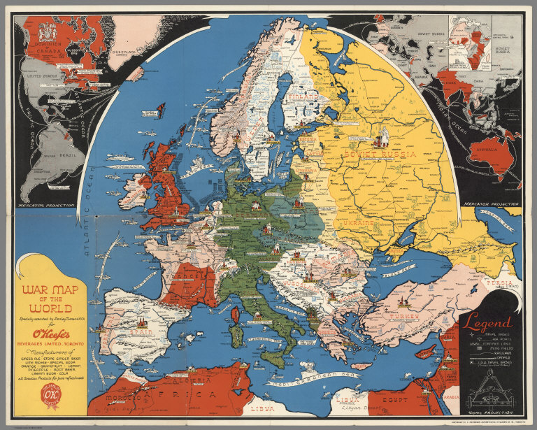
Author
Turner, Stanley
Full Title
War map of the world : specially executed by Stanley Turner A.R.C.A. for O'Keef's Beverages Limited, Toronto. Conic Projection. Copyright C.C. Petersen Advertising, 57 Queen St. W., Toronto. (Western hemisphere. Part of the Eastern hemisphere). British & French empires in Africa.
Publisher
C.C. Petersen Publishing and Advertising
Author
Dussieux, L.
Full Title
55. Carte pour Servir a l'histoire de France depuis 1610 jusqu'en 1789 presentant la division en 38 Governements militaires.
Publisher
Jacques Lecoffre et Comp.
Author
Magnus, Charles
Full Title
Panorama Of The Mississippi Valley And Its Fortifications. Published by C. Magnus, 12 Frankfort Street, New York. Eng. by F.W. Boell.
Publisher
Charles Magnus
Author
Magnus, Charles
Full Title
One Hundred & Fifty Miles Around Richmond. Charles Magnus' New York Printing Establishment - Offices: 12 Frankfort St., New York, and 520 7th St. Washington, D.C. Eleventh Edition 3000 of Magnus' all around Map ... Battle Ground of the Wilderness and Spottsylvania Court House. May, 5-23, 1864. Price 50 Cents. (with 9 small maps) Memphis And Nashville, Tenn. 225 Miles Around Vicksburg, Miss. 250 Miles Around Galveston, Texas. 200 Miles Around Montgomery, Ala. 100 Miles Around Milledgeville, Ga. Fortifications Around Richmond, Va. 250 Miles Around Charleston, S.C. 100 Miles Around Chattanooga, Tenn. Knoxville, Tenn., Danville, Ky. And Parkersburg, Va.
Publisher
Charles Magnus
Author
[Kayser, G., Worret, Charles]
Full Title
Military Map of a part of Eastn. Virginia Department of Maj: Genl: J.A. Dix Comdg 7th Army Corps completed from several Military Reconnaissances & Surveys under the Direction of Capt: Wm. Heine Topt. Engr. U.S. drawn & compiled by Lieut. Ch. Worret & G. Kayser Traced by Lieut. Ch. Worret.
Publisher
No Publisher
Author
Codazzi, Agustin, 1793-1859
Full Title
Mapa de Venezuela para servir a la historia de las campanas de la guerra de independencia en los anos 1812 ... (a) parte de 1819. Lith. de Thierry freres a Paris. (Caracas 1840)
Publisher
[Agostino Codazzi, Thierry Freres.]
Author
Codazzi, Agustin, 1793-1859
Full Title
Mapa de Venezuela, Nueva Granada y Quito, para servir a la historia de las campanas de la guerra de independencia en los anos 1819 y 1820. Lith. de Thierry Frs. a Paris. (Caracas 1840)
Publisher
[Agostino Codazzi, Thierry Freres.]
Author
Codazzi, Agustin, 1793-1859
Full Title
Mapa de los tres Departamentos Venezuela, Cundinamarca y Ecuador que formaron la Republica de Colombia, para servir a la historia de las campanas de la guerra de independencia en los anos de 1821, 1822 y 1823. Lith. de Thierry Frs. a Paris. (Caracas 1840)
Publisher
[Agostino Codazzi, Thierry Freres.]
Author
Codazzi, Agustin, 1793-1859
Full Title
Mapa que contiene una parte de la Republicas del Ecuador, Peru y Bolivia para servir a la Historia de las Campanas del ejerito Colombiano en el alto y bajo Peru, sacado de otro pulicado en 1826 y corregido segun las observaciones e itinerarios de los oficiales facultativos que acompanaron los ejercitos en sus diferentes operaciones. Lith. de Thierry Freres a Paris. (Caracas 1840)
Publisher
[Agostino Codazzi, Thierry Freres.]
Author
Mallory, C.A.
Full Title
(Cover to) Part of the North Bank of the Rappahannock River showing the approaches to Fredericksburg, prepared under the direction of Capt. R.S. Williamson & 1st Lt. Nicholas Bowen ... for the use of the Army of the Potomac compiled by Fred. Churchill Vol. A.D.C. U.S. Coast Survey Chart of the Rappahannock River Surveys and Reconnoissances by C.A. Mallory, Chas. Shoemacker, L.C. Oswell, H.H. Marvin, Geo. F. Lathrop, Assistants. Drawn by C.A. Mallory. Reduced and photographed by L.E. Walker, Treasy. Dept.
Publisher
U.S. Treasury Dept.
Author
Mallory, C.A.
Full Title
Part of the North Bank of the Rappahannock River showing the approaches to Fredericksburg, prepared under the direction of Capt. R.S. Williamson & 1st Lt. Nicholas Bowen ... for the use of the Army of the Potomac compiled by Fred. Churchill Vol. A.D.C. U.S. Coast Survey Chart of the Rappahannock River Surveys and Reconnoissances by C.A. Mallory, Chas. Shoemacker, L.C. Oswell, H.H. Marvin, Geo. F. Lathrop, Assistants. Drawn by C.A. Mallory. Reduced and photographed by L.E. Walker, Treasy. Dept.
Publisher
U.S. Treasury Dept.
Author
Matz, Otto H.
Full Title
(Cover to) Map Of The Country Between Monterey, Tenn. & Corinth, Miss. showing The Lines Of Entrenchments Made & The Routes Followed by The U.S. Forces under the Command of Maj. Genl. Halleck, U.S. Army, In Their Advance Upon Corinth, In May 1862: Surveyed under the direction of Col Geo. Thom, A.D.C. & Chief Of Topl Engrs. Department Of The Mississippi, by Lieuts. Fred. Schraag and C.L. Spangenberg Asst. Topl. Engrs. and drawn by Lieut. Otto H. Matz Asst. Topl. Engr. Lith of J. Bien, 180 Broadway N.Y.
Publisher
J. Bien
Author
Matz, Otto H.
Full Title
Map Of The Country Between Monterey, Tenn. & Corinth, Miss. showing The Lines Of Entrenchments Made & The Routes Followed by The U.S. Forces under the Command of Maj. Genl. Halleck, U.S. Army, In Their Advance Upon Corinth, In May 1862: Surveyed under the direction of Col Geo. Thom, A.D.C. & Chief Of Topl Engrs. Department Of The Mississippi, by Lieuts. Fred. Schraag and C.L. Spangenberg Asst. Topl. Engrs. and drawn by Lieut. Otto H. Matz Asst. Topl. Engr. Lith of J. Bien, 180 Broadway N.Y.
Publisher
J. Bien
Author
[Hall, E.S., Lloyd, H.H., Waters & Son]
Full Title
Military Portraits. Glossary Of War Terms, Maps, Arms, Etc. (Map of) Maryland, Virginia, Chesapeake Bay, Etc., Etc. Published by H.H. Lloyd & Co., 25 Howard Street, New York. Agents wanted to sell this and many other Charts for the times. Entered ... 1861, by H.H. Lloyd & Co.
Publisher
H.H. Lloyd & Co.
Author
[Haskins, Charles, Lloyd, H.H., Viele, Egbert L.]
Full Title
H.H. Lloyd & Co's Campaign Military Charts Showing The Principal Strategic Places Of Interest. Engraved Expressly To Meet A Public Want During The Present War. Compiled From Official Data By Egbert L. Viele, Military and Civil Engineer; and Charles Haskins. Published Under The Auspices Of The American Geographical And Statistical Society. Entered ... 1861 by H.H. Lloyd & Co. H.H. Lloyd & Co's Military Charts. Sixteen Maps On One Sheet.
Publisher
H.H. Lloyd & Co.
Author
Lloyd, H.H.
Full Title
The National Political Chart. Lloyd's New Political Chart, 1861. With a Map of the United States, showing the Free States, Border Slave States, Cotton States, and Territories, in Different Colors. Published at H.H. Lloyd & Co.'s Agents' General Depot for Books, Maps, and Stationery Packages, 25 Howard Street, New York. Entered ... 1861, by H.H. Lloyd & Co. ... New York.
Publisher
H.H. Lloyd & Co.
Author
Spangenberg, Charles
Full Title
Map Of The Siege Of Vicksburg, Miss. By the U.S. Forces Under The Command Of Maj. Genl. U.S. Grant, U.S. Vls. ... Surveyed and constructed under the direction of Capt. C.B. Comstock ... by Major Otto H. Matz ... Chs. Spangenberg ... Drawn by Chs. Spangenberg ... Engr. on stone by J. Schedler No. 120 Pearl St. N.Y. Head Qrs. Of The Dept. Of The Tenn. Vicksburg Miss. Aug. 20th 1863. C.B. Comstock ...
Publisher
J. Schedler
Author
Weyss, John E.
Full Title
Military Map showing the topographical features of the country adjacent to Harper's Ferry Va. including Maryland, Loudoun, and Bolivar Heights, and portions of South and Short Mountains, with the positions of the Defensive Works, also the Junction of the Potomac & Shenandoah Rivers, and their passage through the Blue Ridge. Surveyed from August 3d to Sept. 30th 1863 Under The Direction Of Capt. N. Michler, Corps of Engrs U.S. Army By Major John E. Weyss, Principal Assistant, Engineer Department, Army Of The Potomac ...
Publisher
Engr. Dept U.S. Army
Author
Matz, Otto H.
Full Title
Map Of The Field Of Shiloh, Near Pittsburgh Landing, Tenn. Shewing The Position of the U.S. Forces under the Command Of Maj. Genl. U.S. Grant U.S. Vol. And Maj. Genl. D.C. Buell U.S. Vol. On The 6th And 7th of April 1862. Surveyed Under The Direction Of Col. Geo Thom. Chief of Topl. Engrs. Drawn by Otto H. Matz, Asst. Topl. Engr. Lith. by Chas. Robyn & Co. cor. Chestnut and 3d St, St. Louis Mo.
Publisher
Chas. Robyn & Co.
Author
Poe, Orlando M.
Full Title
Map illustrating the Siege of Atlanta, Ga. by the U.S. Forces, under Command of Maj. Gen. W.T. Sherman from the passage of Peach Tree Creek, July 19th 1864 to the commencement of the movement upon the Enemy's Lines of communication south of Atlanta, August 26, 1864 ... Reduced and engraved in the Engineers Bureau, War Dept. from an original prepared under the directions of Cap. O.M. Poe, Corps of Engs. and Senr. Engr. on Genl Sherman's Staff. Edw. Molitor, Lith.
Publisher
Edward Molitor, Lith.
Author
Hughes, W.C. Major
Full Title
Hughes Military Map Of Richmond & Petersburgh, Va. Showing the Rebel Fortifications drawn on the ground for the War Department by Major W.C. Hughes of Michigan. Published by Philip & Solomons, Washn. D.C. Print by J.F. Gedney, Washn. Willenbucher, Lith. Respectfully dedicated to the Army of the Potomac.
Publisher
Philip & Solomons
Author
Prang, L. & Co.
Full Title
Map of the Atlantic States, Showing Distances From Washington (In BeeLine) By 50 Mile Circles. (The Traveling Distance is about 1/6 to 1/3 more than the BeeLine.) (with) Map of the Battle Ground (with) Map of Norfolk Harbor, Fort Monroe, and Vicinity. (with two insets) Position of Forces at Bull Run and Fortress Monroe. Published By L. Prang & Co. - No. 84 Merchants Row, Boston, Mass. Entered ... 1861 by L. Prang & Co. ... Massachusetts.
Publisher
L. Prang & Co.
Author
Prang, L. & Co.
Full Title
War Telegram Marking Map. L. Prang & Co. Print Publishers, 159, Washington St. Boston ... Entered ... 1862 by L. Prang & Co. ... Massachusetts.
Publisher
L. Prang
Author
[Hall, E.S., New York Herald]
Full Title
War Maps And Diagrams. Our Naval And Military Operations At A Glance. The Coast and Land Line of the Rebellious States ... The Union Blockade of the Atlantic and Gulf Coast ... The Rebel Batteries on the Mississippi ... The Forts on the Southern Sea Line. The New York Herald. New York. Saturday, November 16, 1861. (with) 17 additional maps.
Publisher
New York Herald
Author
[Hall, E.S., New York Herald]
Full Title
Important Operations in Kentucky and Tennessee. The Battle Ground of Gen. Nelson at Piketon--The Brilliant Victory Over the Rebels--Situation of the Bridges Destroyed by the Unionists of Tennessee--The Cumberland Gap--Positions of the Contending Armies, &c., &c., &c. New York Herald War Maps and Diagrams. (Pages) 4 and 5.
Publisher
New York Herald
Author
[Hall, E.S., New York Herald]
Full Title
Seven maps from the New York Herald War Maps and Diagrams. (Pages) 3 and 6. (see note field for titles).
Publisher
New York Herald
Author
[Hall, E.S., New York Herald]
Full Title
The Seat of War in the West. New York Herald War Maps and Diagrams. (Page) 2.
Publisher
New York Herald
Author
[Hall, E.S., New York Herald]
Full Title
Our Brilliant Naval Victory. New York Herald War Maps and Diagrams. (Page) 7.
Publisher
New York Herald
Author
[Hall, E.S., New York Herald]
Full Title
Map of New Orleans and Surrounding Country. (with) The Lower Potomac. New York Herald War Maps and Diagrams. (Page) 8.
Publisher
New York Herald
Author
[Collot, George Henri Victor, Tardieu, P.F.]
Full Title
Plan of Fort Erie. PL. 3.
Publisher
Arthus Bertrand
Author
[Collot, George Henri Victor, Tardieu, P.F.]
Full Title
Plan of Fort Niagara. PL. 4.
Publisher
Arthus Bertrand
|