Who What Where WhenREMOVE |
Author
[Scott, M.M., Vierge, Daniel]
Full Title
Le Tour de Monde en un Clin d'Oeil. Supplement du numero du Monde du la 1er. Janvier 1876 - Dessin de M.M. Scott et Vierge, gravure de M. Meaulle. (on lower center) Monde illustre. Paris. Imprimerie typographique de A. Bourdilliat, 13 Quat Voltaire. - 3189. (on left and right lower corner of map) H. Scott. (and) Vierge(and) F. Mealle, Sc. (on upper margins) Se vend 1 france, y compris le numero du 1er Janvier. Bureaux: 13, quai Voltaire, 13, a Paris.
Publisher
A. Bourdilliat
Author
General Drafting Company
Full Title
Trip Planning Map Of The United States. Happy Motoring! Humble Oil & Refining Company; America's leading Energy Company." Lithographed in U.S.A. W 162. (copyright) MCMLXII, general Drafting Co., Inc., Convent Station, N.J. (inset) Alaska. (inset) Hawaii. (on verso) The United States Trip Planner. (prepared for) Humble Oil & Refining Company. (copyright) MCMLXII, general Drafting Co., Inc., Convent Station, N.J.
Publisher
General Drafting Co.
Author
Foster and Kleiser
Full Title
The Pacific Coast where the nation will converge in 1932 - An Outdoor Advertising Opportunity. Foster and Kleiser Company.
Publisher
Foster and Kleiser
Author
Greyhound Lines
Full Title
Map of the Greyhound Lines and Principal Connecting Carriers in the United States, Canada and Mexico. The Greyhound Lines. (copyright) Greyhound Lines, July, 1935. Litho. In U.S.A. - Commercial, Akron, O.
Publisher
Commercial Litho.
Author
Adams, Sebastian C.
Full Title
(Composite of) Adams' Synchronological Chart of Universal History. Through the Eye to the Mind. A Chronological chart of Ancient, Modern and Biblical History, Synchronized by Sebastian C. Adams. Third Edition and Twelfth-Thousand carefully and critically revised and brought down to 1878. Colby & Co. Publishers, 39 Union Square, New York. The Strowbridge Lithographing Company, Cincinnati, O. Entered According to Act of Congress in the Year A.D. 1871, by S.C. Admas, in the Office of the Librarian of Congress at Washington, D.C. (On the title page) Adams' Synchronological Chart of Universal History...Through the Eye to the Mind.
Publisher
Colby & Co.
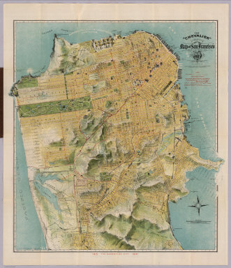
Author
Chevalier, August
Full Title
(Covers to) The "Chevalier" Commercial, Pictorial and Tourist Map of San Francisco From Latest U.S. Gov. and Official Surveys. Designed-Engraved And Copyrighted By Aug. Chevalier, Lithographer Publisher, 507 Mission St. San Francisco ... The Exposition City 1915. Copyrighted 1912 By Aug. Chevalier ... (on verso) An index to the street and text.
Publisher
August Chevalier
Author
Chevalier, August
Full Title
The "Chevalier" Commercial, Pictorial and Tourist Map of San Francisco From Latest U.S. Gov. and Official Surveys. Designed-Engraved And Copyrighted By Aug. Chevalier, Lithographer Publisher, 507 Mission St. San Francisco ... The Exposition City 1915. Copyrighted 1912 By Aug. Chevalier ... (on verso) Untitled index to the street, parks, Public Schools ... of San Francisco.
Publisher
August Chevalier
Author
Chevalier, August
Full Title
(Index Page to) Untitled index to the Street, parks, Public Schools ... of San Francisco. (on verso) The "Chevalier" Commercial, Pictorial and Tourist Map of San Francisco From Latest U.S. Gov. and Official Surveys. Designed-Engraved And Copyrighted By Aug. Chevalier, Lithographer Publisher, 507 Mission St. San Francisco ... The Exposition City 1915. Copyrighted 1912 By Aug. Chevalier ...
Publisher
August Chevalier
Author
Transcontinental Air Transport, Inc.
Full Title
(Map of the United States showing the air route from Los Angeles, California to Columbus, Ohio). Copyright, Rand McNally & Company.
Publisher
Transcontinental Air Transport, Inc.
Author
Transcontinental Air Transport, Inc.
Full Title
Illustrated Map of the Route of Transcontinental Air Transport, Inc. TAT. Copyright, Rand McNally & Company. 7134 - New York 6-29.
Publisher
Transcontinental Air Transport, Inc.
Author
[Phelps, Humphrey, Ensign & Thayer]
Full Title
World At One View. Entered ... 1847, by H. Phelps ... New York. Published by Ensign & Thayer, 36 Ann Street, New York. (inset views) Panoramic View of the Route to China, by the Oregon Railroad and the Pacific Ocean. This Road once Built, Would Become the Great Highway of Nations ; (Mountains of the) Eastern Hemisphere ; Female costumes of the Different Parts of the World ; (Mountains of the) Western Hemisphere ; Waterspout. (inset illustrations of) Caucasian ; Mongul ; African ; Malay.
Publisher
Ensign & Thayer
Author
Clark, Estra
Full Title
Historic York. Printed and Published by Ben Johnson & Co. Ltd; York, Englalnd. Estra Clark. 1947.
Publisher
Ben Johnson & Co. Ltd.
Author
Clark, Estra
Full Title
Historic York. Printed and Published by Ben Johnson & Co. Ltd; York, Englalnd. Estra Clark. 1947.
Publisher
Ben Johnson & Co. Ltd.
Author
[Nelson, Bruce N., The Islander Company]
Full Title
Pictorial Map ... Guam Island. The Marianas Islands.
Publisher
The Islander Company
Author
[Nelson, Bruce N., The Islander Company]
Full Title
The Historical Island of Guam of the Marianas Islands.
Publisher
The Islander Company
Author
Maduro Jr., I.L.
Full Title
(Covers to) Bird's Eye View of the Panama Canal and Map of Panama. I.L. Maduro Jr, Panama.
Publisher
I.L. Maduro Jr.,
Author
Maduro Jr., I.L.
Full Title
(Text Page) (Panama Canal Photographs and Descriptions).
Publisher
I.L. Maduro Jr.,
Author
Maduro Jr., I.L.
Full Title
Profile of Panama Canal. Bird's Eye View of the Panama Canal. Map of Panama. I.L. Maduro Jr, Panama.
Publisher
I.L. Maduro Jr.,
Author
Bloodgood, Don
Full Title
The California Pacific International Exposition - San Diego.
Publisher
Shell Oil Company
Author
Bloodgood, Don
Full Title
California Pacific International Exposition. May 29 to November 11, 1935.
Publisher
Shell Oil Company
Author
Jones, Amy
Full Title
The Booklover's Map of the United States. (insets) The Boston Area. The Chicago Area. The New York Area.
Publisher
R.R. Bowker Co.
Author
Chevalier, August
Full Title
The "Chevalier" Commercial, Pictorial and Tourist Map of San Francisco From Latest U.S. Gov. and Official Surveys. Designed-Engraved And Copyrighted By Aug. Chevalier, Lithographer Publisher, San Francisco ... copyrighted 1911 ...
Publisher
Aug. Chevalier
Author
[Raisz, Erwin, Canet, Gerardo]
Full Title
Mapa de los Paisajes de Cuba por Gerardo Canet com la colaboracion de Erwin Raisz. (inset) La Habana y sus alrededores.
Author
Mora, Jo (1876-1947)
Full Title
California.
Publisher
Jo Mora Publications
Author
Thompson, Kenneth W.
Full Title
The Americas Served by American Republic Lines ; Grace Line ; Pan American Airways System Pan American-Grace Airways ; United Fruit Company. (by) Kenneth W. Thompson. Printed in U.S.A.
Publisher
No publisher
Author
New Mexico State Tourist Bureau
Full Title
(Covers to) Recreational map of New Mexico land of enchantment. (on verso) Recreational map of New Mexico : the land of enchantment. Printed ... distributed by the New Mexico State Tourist Bureau a division of the State Highway Department, State Capitol, Santa Fe. Copyright 1946, New Mexico State Tourist Bureau, Santa Fe, New Mexico. Litho. in U.S.
Publisher
New Mexico State Tourist Bureau a division of the State Highway Department
Author
New Mexico State Tourist Bureau
Full Title
Recreational map of New Mexico : the land of enchantment. Printed ... distributed by the New Mexico State Tourist Bureau a division of the State Highway Department, State Capitol, Santa Fe. Copyright 1946, New Mexico State Tourist Bureau, Santa Fe, New Mexico. Litho. in U.S. (on verso) panel title, portfolio, text, descriptive tourist notes.
Publisher
New Mexico State Tourist Bureau a division of the State Highway Department
Author
New Mexico State Tourist Bureau
Full Title
(Text Page to) Recreational map of New Mexico land of enchantment (with tourist information) Parks and monuments, Highways, Climate, Sports, Indians, Mountains, The old West. (on verso) Recreational map of New Mexico : the land of enchantment. Printed ... distributed by the New Mexico State Tourist Bureau a division of the State Highway Department, State Capitol, Santa Fe. Copyright 1946, New Mexico State Tourist Bureau, Santa Fe, New Mexico. Litho. in U.S.
Publisher
New Mexico State Tourist Bureau a division of the State Highway Department
Author
Brown, Harold Haven
Full Title
The picture map of the Holy Land. Designed and drawn by Harold Haven Brow. Published by R.R. Bowker Company, 62 West 45th St., New York, Copyright 1928. (insets) Jerusalem and its environs. Jerusalem. Profile view of Palestine showing relative height and position of important localities. Map of Palestine showing heights of land thus: Yellow , 0-500 ft; Purple, 500-1500 ft; 1500-300 ft; Pink, over 3000 ft. Black, below sea level.
Publisher
R.R. Bowker Company
Author
Brown, Harold Haven
Full Title
Picture map of Massachusetts. Designed and drawn by Harold Haven Brown. Published by R.R. Bowker Company, 62 West 45th St., New York, Copyright 1930. (insets) Boston during three centuries ; Battle of Bunker Hill ; Boston & country adjacent ; bunker Hill Monument.
Publisher
R.R. Bowker Company
Author
New Mexico. State Tourist Bureau
Full Title
(Covers to) Historical trails through New Mexico : the land of enchantment (on verso pictorial map of) Historical trails through New Mexico : the land of enchantment ; prepared for free distribution by the New Mexico State Tourist Bureau, a Division of the State Highway Department, Santa Fe, New Mexico. Litho. by Johnson Printing Inc., Eau. Claire Wis. Copyright 1951, New Mexico State Tourist Bureau, Santa Fe, New Mexico.
Publisher
[New Mexico State Tourist Bureau, Johnson Printing Inc.]
Author
New Mexico. State Tourist Bureau
Full Title
Historical trails through New Mexico : the land of enchantment ; prepared for free distribution by the New Mexico State Tourist Bureau, a Division of the State Highway Department, Santa Fe, New Mexico. Litho. by Johnson Printing Inc., Eau. Claire Wis. Copyright 1951, New Mexico State Tourist Bureau, Santa Fe, New Mexico. (on verso: cover title and text).
Publisher
[New Mexico State Tourist Bureau, Johnson Printing Inc.]
Author
New Mexico. State Tourist Bureau
Full Title
(Text Page to) Historical trails through New Mexico : the land of enchantment (on verso pictorial map of) Historical trails through New Mexico : the land of enchantment ; prepared for free distribution by the New Mexico State Tourist Bureau, a Division of the State Highway Department, Santa Fe, New Mexico. Litho. by Johnson Printing Inc., Eau. Claire Wis. Copyright 1951, New Mexico State Tourist Bureau, Santa Fe, New Mexico.
Publisher
[New Mexico State Tourist Bureau, Johnson Printing Inc.]
Author
Williams, Robert
Full Title
The Mystery Map of Assinine Atoll. (c)opyright Robert Williams, 77.
Publisher
No Publisher
Author
McCandlish, Edward
Full Title
Bootlegger's Map of the United States "Honi soit qui mal y pints". Copyright by Edward McCandlish. The Griswold Press- Printed in U.S.A.
Publisher
Griswold Press
Author
Upper Peninsula Development Bureau
Full Title
Copper Country - Keweenaw Land. Gateway to Isle Royale.
Publisher
Upper Peninsula Development Bureau
Author
Upper Peninsula Development Bureau
Full Title
Keweenaw County.
Publisher
Upper Peninsula Development Bureau
Author
Upper Peninsula Development Bureau
Full Title
Ontonagon County.
Publisher
Upper Peninsula Development Bureau
Author
Upper Peninsula Development Bureau
Full Title
Gogebic County.
Publisher
Upper Peninsula Development Bureau
Author
Upper Peninsula Development Bureau
Full Title
Dickinson County.
Publisher
Upper Peninsula Development Bureau
Author
Upper Peninsula Development Bureau
Full Title
Iron County.
Publisher
Upper Peninsula Development Bureau
Author
Upper Peninsula Development Bureau
Full Title
Schoolcraft County.
Publisher
Upper Peninsula Development Bureau
Author
Upper Peninsula Development Bureau
Full Title
Luce County.
Publisher
Upper Peninsula Development Bureau
Author
Upper Peninsula Development Bureau
Full Title
Chippewa County.
Publisher
Upper Peninsula Development Bureau
Author
Upper Peninsula Development Bureau
Full Title
Mackinac County.
Publisher
Upper Peninsula Development Bureau
Author
Upper Peninsula Development Bureau
Full Title
Macinac Island.
Publisher
Upper Peninsula Development Bureau
Author
[Aaron Blake Publishers, Zeleznik, John, Lewis, Susan]
Full Title
The Ian Fleming Thriller Map.
Publisher
Aaron Blake Publishers
Author
[Aaron Blake Publishers, Zeleznik, John, Lewis, Susan]
Full Title
The Ian Fleming Thriller Map.
Publisher
Aaron Blake Publishers
Author
Upper Peninsula Development Bureau
Full Title
Menominee County.
Publisher
Upper Peninsula Development Bureau
|