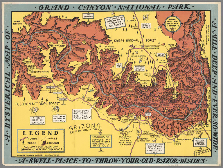
Who What Where WhenREMOVE |
Author
Lindgren Brothers
Full Title
A Hysterical Map of the Grand Canyon National Park.
Publisher
Lindgren Brothers
Author
Bloodgood, Don
Full Title
A Pic-Tour Map. Honolulu, Waikiki and 'Round the Isle of Oahu. Waikiki Beach. (inset) Hawaiian Islands.
Publisher
Ray Helbig's Hawaiian Service
Author
Bloodgood, Don
Full Title
A Pic-Tour Map. Honolulu, Waikiki and 'Round the Isle of Oahu. Waikiki Beach. (inset) Hawaiian Islands.
Publisher
Ray Helbig's Hawaiian Service
Author
Pacific Stars and Stripes
Full Title
Pacific Stars and Stripes Map of the (Korean) War. (inset) 38th Parallel.
Publisher
Pacific Stars and Stripes
Author
Atwood, Mary Hall
Full Title
Long Beach, Southern California, Los Angeles County.
Publisher
(Long Beach) Chamber of Commerce
Author
Atwood, Mary Hall
Full Title
Make Long Beach Your Vacation Headquarters.
Publisher
(Long Beach) Chamber of Commerce
Author
Atwood, Mary Hall
Full Title
Los Angeles County. Long Beach.
Publisher
(Long Beach) Chamber of Commerce
Author
[Lites, Arthur, (Palo Alto) Chamber of Commerce]
Full Title
Palo Alto, California. A Pictorial Map.
Publisher
City of Palo Alto
Author
[Lites, Arthur, (Palo Alto) Chamber of Commerce]
Full Title
Palo Alto, Ideal Home and Recreational Center.
Publisher
City of Palo Alto
Author
[Lites, Arthur, (Palo Alto) Chamber of Commerce]
Full Title
A Pictorial Map of Palo Alto and the San Francisco Peninsula. Palo Alto, A Pictorial Map Drawn from the View Point (Birdseye) of One Aboard a Coastwise Air Liner.
Publisher
City of Palo Alto
Author
Cressy, Mike
Full Title
(Covers to) The Literary Map of Latin America.
Publisher
Aaron Blake Publishers
Author
Cressy, Mike
Full Title
The Literary Map of Latin America.
Publisher
Aaron Blake Publishers
Author
[Bank of America, California State Fair]
Full Title
(Covers to) '49ers guide to the Mother Lode, Mariposa to Downieville : with map ; profusely illustrated. A souvenir of the California State Fair, with complements of Bank of America National Trust and Savings Association. copyright 1949, bank of America Nt & SA. Photographs from Otheto Weston's Mother Lode Album, Stanford University Press. (on verso map of) The Mother Lode of California.
Publisher
Bank of America National Trust and Savings Association
Author
[Bank of America, California State Fair]
Full Title
(Text Page to) '49ers guide to the Mother Lode, Mariposa to Downieville : with map ; profusely illustrated. A souvenir of the California State Fair, with complements of Bank of America National Trust and Savings Association. copyright 1949, bank of America Nt & SA. Photographs from Otheto Weston's Mother Lode Album, Stanford University Press. (on verso map of) The Mother Lode of California.
Publisher
Bank of America National Trust and Savings Association
Author
[Bank of America, California State Fair]
Full Title
The Mother Lode of California. (on verso) '49ers guide to the Mother Lode, Mariposa to Downieville : with map ; profusely illustrated. A souvenir of the California State Fair, with complements of Bank of America National Trust and Savings Association. copyright 1949, bank of America Nt & SA. Photographs from Otheto Weston's Mother Lode Album, Stanford University Press.
Publisher
Bank of America National Trust and Savings Association
Author
[Lindgren Brothers, Lindgren, Jolly]
Full Title
A Hysterical Map of the Grand Coulee Dam.
Publisher
Lindgren Brothers
Author
C. Barnes Cartography
Full Title
Mt. Rainier National Park. --Willy Nilly Map + C. Barnes. Cart. '46 -- Wonderland Trail --
Publisher
Willy Nilly Map
Author
C. Barnes Cartography
Full Title
Mt. Rainier Nat. Park Boasting Chart.
Publisher
Willy Nilly Map
Author
[Shurtleff, Elizabeth, McMillin, Helen F.]
Full Title
(Text Page) Map of the Bermuda Islands.
Publisher
The Graphic History Association
Author
[Shurtleff, Elizabeth, McMillin, Helen F.]
Full Title
A Map of the Bermuda Islands. Sa des Demonias Isles of the Devils.
Publisher
[Elizabeth Shurtleff, Helen F. McMillin]
Author
Bollmann, Hermann (1911-1971)
Full Title
New York (City) Picture Map.
Publisher
Pictorial Maps, Inc.
Author
Colortext Publications Inc.
Full Title
Story Map of Ireland.
Publisher
Colortext Publications Inc.
Author
Chase, Ernest Dudley, 1878-1966
Full Title
(Covers to) Total War, Battle Map. Designed and Drawn by Ernest Dudley Chase of Winchester, Massachusetts, U.S.A. Certain Victory Will be Ours.
Publisher
Ernest Dudley Chase
Author
Chase, Ernest Dudley, 1878-1966
Full Title
(Text Page) In an All-Out Victory.
Publisher
Ernest Dudley Chase
Author
Chase, Ernest Dudley, 1878-1966
Full Title
Total War, Battle Map. Designed and Drawn by Ernest Dudley Chase of Winchester, Massachusetts, U.S.A. Certain Victory Will be Ours.
Publisher
Ernest Dudley Chase
Author
Chase, Ernest Dudley, 1878-1966
Full Title
World Wonders, A Pictorial Map. Designed and Drawn by Ernest Dudley Chase of Winchester, Mass.
Publisher
Ernest Dudley Chase
Author
[Witta, Jr. Fred, Golden Chain Council of the Mother Lode.]
Full Title
(Covers to) California's Golden Chain : the Mother Load Highway (State Highway 49). Ledger Press, Jackson. (on verso map) California's Golden Chain : the Mother Lode. Designed by Fred Witta, Jr. Amador County. Art work by Pope Studio, Sacramento. (printed by) Sacramento Lithograph Co. Copyright.
Publisher
[Ledger Press, Sacramento Lithograph Co.]
Author
[Witta, Jr. Fred, Golden Chain Council of the Mother Lode.]
Full Title
(Text page to) California's Golden Chain : the Mother Load Highway (State Highway 49). Ledger Press, Jackson. (on verso map) California's Golden Chain : the Mother Lode. Designed by Fred Witta, Jr. Amador County. Art work by Pope Studio, Sacramento. (printed by) Sacramento Lithograph Co. Copyright.
Publisher
[Ledger Press, Sacramento Lithograph Co.]
Author
[Witta, Jr. Fred, Golden Chain Council of the Mother Lode.]
Full Title
California's Golden Chain : the Mother Lode. Designed by Fred Witta, Jr. Amador County. Art work by Pope Studio, Sacramento. (printed by) Sacramento Lithograph Co. Copyright. (on verso cover title) California's Golden Chain : the Mother Load Highway (State Highway 49). Ledger Press, Jackson.
Publisher
[Ledger Press, Sacramento Lithograph Co.]
Author
Chase, Ernest Dudley, 1878-1966
Full Title
The pictorial map : United States Stamps. Designed, drawn and published by Ernest Dudley Chase. Winchester, Mass.; Research directors Charles Peck Kerr and Rupert Frank Jones. The post : Artists: Famous American Commemorative Series -- 1940.
Publisher
Ernest Dudley Chase.
Author
Sarg, Anthony
Full Title
Residential Main St. Nantucket Mass. Designed by Tony Sarg. 1937.
Publisher
No Publisher
Author
Sheets, Millard
Full Title
The Panorama Today in Northern California its resources activities and opportunities. Published on its 100th. Anniversary by American Trust Company, San Francisco. Millard Sheets. Lithogravure in U.S.A.
Publisher
American Trust Company
Author
Sheets, Millard
Full Title
The Pageant of History in Northern California its colorful and adventurous beginnings. Published on its 100th. Anniversary by American Trust Company, San Francisco. Millard Sheets. Lithogravure in U.S.A.
Publisher
American Trust Company
Author
[Carrigen, Tom, Wyoming Motor Court Association]
Full Title
Paint-Brush Map of Wyoming. (By) Tom Carrigen. Copyright 1938, Prairie Pub. Co., Revised 1953. (and Panel title) Welcome to wonderful Wyoming. Wyoming directory of Motels ... Published by Wyoming Motor Court Association, Inc. in cooperation with Wyoming Commerce & Industry commission, Cheyenne, Wyoming.
Publisher
[Prairie Pub. Co., Wyoming Motor Court Association, Inc.]
Author
Paine, Paul M.
Full Title
Map of America's making : a chart of places and events for those who would sail with the discoverers, seek freedom with the colonists, follow the westward trails, subdue the wilderness, and behold the building of the Republic. F. Haase. Copyright by Paul M. Paine, 1925 - 1926 - 1929 - 1939. R.R. Bowker Company. 62 West 45th Street, New York, N.Y. (inset) Where American History began [Northeast.].
Publisher
R.R. Bowker Co.
Author
Rude, Klengston
Full Title
Pano-view map : California, Nevada. Progressive. Historical. Spectacular. Recreational. Kleng Rude. C(opyright) 1962 Kleng Rude Studios, Long Beach.
Publisher
Kleng Rude Studios
Author
Lundy, Fred
Full Title
San Francisco Bay. (with) part of San Francisco and Oakland. (Drawn by) Fred Lundy - 1934. Copyright, 1934, by The Tribune Publishing Co.
Publisher
Tribune Pub. Co.
Author
Lee, Kerry
Full Title
London, The Bastion of Liberty.
Publisher
Pictorial Maps Ltd.
Author
[Shope, Irvin, Fletcher, Bob]
Full Title
Frontier - Montana - Pioneer. A One Page History Dedicated to the Pioneers.
Publisher
Montana State Highway Department
Author
Sarg, Tony (1880-1942)
Full Title
The New York 1939 Official World's Fair Pictorial Map Created by Tony Sarg.
Publisher
Tony Sarg Publications
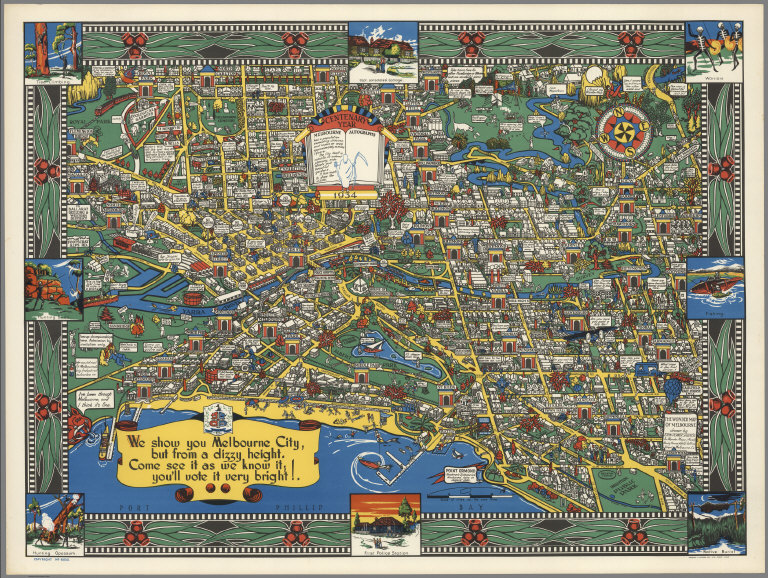
Author
John Power Studios
Full Title
The Wonder Map of Melbourne drawn by John Power Studios.
Publisher
Wonder Maps (Aust.).
Author
[Butler, Lowell, Newbro, William H., Robinson, William W.]
Full Title
(Covers to) A map of the missions, presidios, pueblos, and some of the more interesting ranchos of Spanish California : together with the routes of the principal land explorations therein. Published by Westways. (copyright) 1956 by the Automobile Club of Southern California. (on opposite page) A note of Explanation (by) Phil Townsend Hanna
Publisher
[Westways, Automobile Club of Southern California]
Author
[Butler, Lowell, Newbro, William H., Robinson, William W.]
Full Title
A map of the missions, presidios, pueblos, and some of the more interesting ranchos of Spanish California : together with the routes of the principal land explorations therein. Compiled by W. W. Robinson and William H. Newbro, Jr. ; edited by Phil Townsend Hanna ; cartography by Lowell Butler ; Drawings by Ken Sawyer ; color by Harry O. Diamond ; (on lower margin) December 1956, Westways, Vol. 48, No. 12. (insets) San Francisco -Monterey Area ; Los Angeles and vicinity Area.
Publisher
[Westways, Automobile Club of Southern California]
Author
[Butler, Lowell, Webb, William, Hanna, Phil Townsend, 1896-1957]
Full Title
(Covers to) Outdoor play places of California : a cartographic map of some of the outstanding recreational areas of the Golden State : Published by Westways ; Copyright 1954 by the Automobile Club of Southern California. (on opposite page) A note of Explanation (by) Phil Townsend Hanna.
Publisher
[Westways, Automobile Club of Southern California]
Author
[Butler, Lowell, Webb, William, Hanna, Phil Townsend, 1896-1957]
Full Title
Outdoor play places of California : a cartographic map of some of the outstanding recreational areas of the Golden State : designed by Lowell Butler with descriptive notes by William Webb and Phil Townsed Hanna. Copyright 1954 by the Automobile Club of Southern California. Drawings by Ken Sawyer. Color by Harry O. Diamond. (on lower margin) December 1954, Westways, Vol. 46, No. 12.
Publisher
[Westways, Automobile Club of Southern California]
Author
[Butler, Lowell, Webb, William, Hanna, Phil Townsend, 1896-1957]
Full Title
(Covers to) A Map of the Marked Historical Sites of California : Compiled from the official registrations of the California State Department of Natural Resources: Published by Westways ; Copyright 1952 by the Automobile Club of Southern California. (on opposite page) A note of Explanation (by) Phil Townsend Hanna.
Publisher
[Westways, Automobile Club of Southern California]
Author
[Butler, Lowell, Webb, William, Hanna, Phil Townsend, 1896-1957]
Full Title
(Text Page to) A Map of the Marked Historical Sites of California : Compiled from the official registrations of the California State Department of Natural Resources : By Phil Townsend Hanna and William Webb : Cartography By Lowell Butler. Copyright 1952 by the Automobile Club of Southern California. Drawing by Gordon Brusstar. Color by Harry Diamond. (on lower margin) December 1952, Westways, Vol. 44, No. 12.
Publisher
[Westways, Automobile Club of Southern California]
Author
[Butler, Lowell, Webb, William, Hanna, Phil Townsend, 1896-1957]
Full Title
A Map of the Marked Historical Sites of California : Compiled from the official registrations of the California State Department of Natural Resources : By Phil Townsend Hanna and William Webb : Cartography By Lowell Butler. Copyright 1952 by the Automobile Club of Southern California. Drawing by Gordon Brusstar. Color by Harry Diamond. (on lower margin) December 1952, Westways, Vol. 44, No. 12.
Publisher
[Westways, Automobile Club of Southern California]
Author
[International Tea Market Expansion Board Limited, Gill, Leslie MacDonald, 1884-1947]
Full Title
Tea. Revives. The. World. MacDonald Gill 1940. Issued by the International Tea Market Expansion Board Limited. Printed in England. S.H.B. Ltd. Regd. No. 4950.
Publisher
International Tea Market Expansion Board Limited
|