Who What Where WhenREMOVE |
Author
Nell, Louis
Full Title
Nell's Topographical & Township Map of the State of Colorado. Compiled from U.S. Government Surveys & other authentic Sources. Washington D.C. 1884. Chain & Hardy, Agents. 414 Larimer Str. Denver. Entered ... 1881, by Louis Nell ... Washington D.C. Am. Photo-Litho. Co. N.Y.
Publisher
Chain & Hardy
Author
Nell, Louis
Full Title
Nell's Topographical Map Of The State Of Colorado. E.Besly & Co. Publishers, Denver. 1889. Copyright by Louis Nell, Washington D.C. 1887. Photo-Lith., Century Lith. Co. Phila. Pa.
Publisher
E. Besly
Author
Thayer, H. L.
Full Title
Thayer's Map Of Colorado. Published By H.L. Thayer, Denver, Col. 1880. Note. From Surveys of the General Land Office, used by permission, revised & corrected to date by the Publisher. Photo lith & print by Julius Bien 16 & 18 Park Place N.Y.
Publisher
H.L. Thayer
Author
Nell, Louis
Full Title
Nell's Topographical Map Of The State Of Colorado. The Kendrick Book & Stationery Co. Denver, 1906. C.A. Kendrick, Pres. H.E. Bellamy, Vice Pres. Copyright by Louis Nell, Denver, Colo. 1903. The Friedenwald Co. Photo-Lith. Balto.
Publisher
Kendrick Book & Stationery Co.
Author
Rand McNally and Company
Full Title
Rand, McNally & Co.'s Colorado. Rand McNally & Co., Map Publishers and Engravers, Chicago, 1907. Rand, McNally & Co.'s New Business Atlas Map of Colorado. Copyright, 1906, ... 1904 ... (with 33 page index) Rand, McNally & Co.'s Indexed County And Township Pocket Map And Shippers' Guide Of Colorado ... Chicago And New York: Rand, McNally & Co. ... (on verso) Copyright, 1907, by Rand, McNally & Co., Chicago.
Publisher
Rand McNally & Co.
Author
Rand McNally and Company
Full Title
Rand, McNally & Co.'s Colorado. Rand McNally & Co., Map Publishers and Engravers, Chicago, 1912. The Rand-McNally & Co.'s New Commercial Atlas Map of Colorado. Copyright by Rand-McNally & Co. (with 62 page index) Rand McNally & Co.'s Indexed County And Township Pocket Map And Shippers' Guide Of Colorado ... Chicago And New York: Rand McNally & Co. ... (on verso) Copyright, 1912, by Rand, McNally & Co., Chicago.
Publisher
Rand McNally & Co.
Author
Thayer, H. L.
Full Title
Thayer's Map Of Colorado. Published by Richards & Co. Denver, Colorado. 1873. Third Edition. Rufus Blanchard Engraver.
Publisher
Richards & Co.
Author
Thayer, H. L.
Full Title
Thayer's Map of Denver Colorado. Located to Tp. Nos 3&4 South Range No. 68 West Arapahoe County. Published by H.L Thayer. Real Estate Mining And Loan Agent Denver. 1879. Thayer's Map Publishing House ... No. 354-1/2 Lawrence Street. Entered ... 1878, by H.L. Thayer ... Washington.
Publisher
H.L. Thayer
Author
[Rollandet, Edward, Thayer, H. L.]
Full Title
Thayer's New Map Of The State of Colorado Compiled From Official Surveys And Explorations. Published by H.L. Thayer, Denver Col. 1880. Established in 1871. Drawn By Edward Rollandet. Entered ... 1878 by H.L Thayer ... Washington.
Publisher
H.L. Thayer
Author
[Thayer, H. L., U.S. General Land Office]
Full Title
Thayer's map of Colorado. Published by H.L. Thayer, Denver, Col. 1882. Note. From surveys of the General Land Office, used by permission, revised & corrected to date by the publisher. Photo lith. & print. by Julius Bien & Co., 16 & 18 Park Place, N.Y.
Publisher
H.L. Thayer
Author
Nell, Louis
Full Title
Nell's topographical map of the state of Colorado. Hamilton & Kendrick, Denver. 1895. Copyright by Louis Nell, Denver, Colo. 1895. Maps of every description prepared by Louis Nell, Denver.
Publisher
Hamilton & Kendrick
Author
Clason Map Company
Full Title
Approved Mineral Surveys Of The Principal Mining Districts In Boulder County Colorado. 1916. Published By The Clason Map Co. 1515 Tremont Place, Denver, Colo. Copyrighted 1916 by The Clason Map Co. Denver, Colo.
Publisher
Clason Map Company
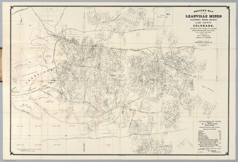
Author
Thayer, H.L.
Full Title
Thayer's Map Of The Leadville Mines California Mining District Lake County Colorado. ... Compiled From The United States Surveys And County Records. Published by H.L. Thayer, Leadville, Colorado. Julius Bien, Photo-Lith. N.Y.
Publisher
H.L. Thayer
Author
[Page, H.R. & Co., Blake, J.A]
Full Title
Blake's New Map Of Colorado. 1881. J.A. Blake, Publisher, 294 Fifteenth Street, Denver. Copyrighted 1880 by H.R. Page. A. Loehnes.
Publisher
J.A. Blake
Author
Nell, Louis
Full Title
Nell's Topographical Map Of The State Of Colorado. The Kendrick Book & Stationery Co. Denver, 1905. C.A. Kendrick, Pres. H.E. Bellamy, Vice Pres. Copyright by Louis Nell, Denver, Colo. 1903. The Friedenwald Co. Photo-Lith. Balto.
Publisher
Kendrick Book & Stationery Co.
Author
Thayer, H.L.
Full Title
Thayer's Map of Colorado. Published by H.L. Thayer & Co. Denver, Colorado. 1875. Sixth Edition. Entered ... 1875 by H.L. Thayer & Co. ... Washington. Rufus Blanchard Engraver. H.L. Thayer Draftsman.
Publisher
H.L. Thayer
Author
Colton. G.W. & C.B.
Full Title
Colton's Sectional & Topographical Map of Colorado. Published by G.W. & C.B. Colton & Co. 172 William St. New York. 1871. Entered ... 1871 by G.W. & C.B. Colton & Co. ... Washington.
Publisher
G.W. & C.B. Colton
Author
[Ebert, Frederick J., Gilpin, William, 1822-1894, Monk, Jacob]
Full Title
Map Of Colorado Territory, Shewing The System Of Parks. Drawn by Frederick J. Ebert under direction of the Governor Wm. Gilpin. Published by Jacob Monk, Philadelphia, Pa. 1865. Thos. Sinclair's lith. Philada.
Publisher
Jacob Monk
Author
Adams, George H. & Son
Full Title
Geo. H. Adams & Son Colorado. Copyright 1884, By Geo. H. Adams & Son, New York.
Publisher
George H. Adams & Son.
Author
Rand McNally and Company
Full Title
Rand, McNally & Co.'s new geological map of Colorado. Copyright, 1879, by Rand, McNally & Co.
Publisher
Rand McNally & Co.
Author
Nell, Louis
Full Title
(Covers to) Nell's Topographical & Township Map of the State of Colorado. Compiled from U.S. Government Surveys & other authentic Sources. Washington D.C. 1884. Chain & Hardy, Agents. 414 Larimer Str. Denver. Entered ... 1881, by Louis Nell ... Washington D.C. Am. Photo-Litho. Co. N.Y.
Publisher
Chain & Hardy
Author
Nell, Louis
Full Title
(Covers to) Nell's Topographical Map Of The State Of Colorado. E.Besly & Co. Publishers, Denver. 1889. Copyright by Louis Nell, Washington D.C. 1887. Photo-Lith., Century Lith. Co. Phila. Pa.
Publisher
E. Besly
Author
Thayer, H. L.
Full Title
(Covers to) Thayer's Map Of Colorado. Published By H.L. Thayer, Denver, Col. 1880. Note. From Surveys of the General Land Office, used by permission, revised & corrected to date by the Publisher. Photo lith & print by Julius Bien 16 & 18 Park Place N.Y.
Publisher
H.L. Thayer
Author
[Colton, J. H., Warren, Gouverneur Kemble, 1830-1882, Redpath, James, Hinton, Richard J]
Full Title
Kansas and Nebraska. 1859. (inset map) Nebraska and Kansas, Showing Pikes Peak And The Gold Region. 1859. (Published) by J.H. Colton & Co., 172 William St., New York.
Publisher
J. H. Colton.
Author
[Colton, J. H., Warren, Gouverneur Kemble, 1830-1882, Redpath, James, Hinton, Richard J]
Full Title
Military Map of Parts of Kansas, Nebraska and Dakota. By Lieut. G.K. Warren Top. Engrs. from the Explorations made by him in 1855, 56 & 57. (Published) by J.H. Colton & Co., 172 William St., New York.
Publisher
J. H. Colton.
Author
Nell, Louis
Full Title
(Covers to) Nell's Topographical Map Of The State Of Colorado. The Kendrick Book & Stationery Co. Denver, 1906. C.A. Kendrick, Pres. H.E. Bellamy, Vice Pres. Copyright by Louis Nell, Denver, Colo. 1903. The Friedenwald Co. Photo-Lith. Balto.
Publisher
Kendrick Book & Stationery Co.
Author
Nell, Louis
Full Title
(Index Page to) Nell's Topographical Map Of The State Of Colorado. The Kendrick Book & Stationery Co. Denver, 1906. C.A. Kendrick, Pres. H.E. Bellamy, Vice Pres. Copyright by Louis Nell, Denver, Colo. 1903. The Friedenwald Co. Photo-Lith. Balto.
Publisher
Kendrick Book & Stationery Co.
Author
Rand McNally and Company
Full Title
(Covers to) Rand, McNally & Co.'s Colorado. Rand McNally & Co., Map Publishers and Engravers, Chicago, 1907. Rand, McNally & Co.'s New Business Atlas Map of Colorado. Copyright, 1906, ... 1904 ... (with 33 page index) Rand, McNally & Co.'s Indexed County And Township Pocket Map And Shippers' Guide Of Colorado ... Chicago And New York: Rand, McNally & Co. ... (on verso) Copyright, 1907, by Rand, McNally & Co., Chicago.
Publisher
Rand McNally & Co.
Author
Rand McNally and Company
Full Title
(Title Page to) Rand, McNally & Co.'s Colorado. Rand McNally & Co., Map Publishers and Engravers, Chicago, 1907. Rand, McNally & Co.'s New Business Atlas Map of Colorado. Copyright, 1906, ... 1904 ... (with 33 page index) Rand, McNally & Co.'s Indexed County And Township Pocket Map And Shippers' Guide Of Colorado ... Chicago And New York: Rand, McNally & Co. ... (on verso) Copyright, 1907, by Rand, McNally & Co., Chicago.
Publisher
Rand McNally & Co.
Author
Rand McNally and Company
Full Title
(Covers to) Rand, McNally & Co.'s Colorado. Rand McNally & Co., Map Publishers and Engravers, Chicago, 1912. The Rand-McNally & Co.'s New Commercial Atlas Map of Colorado. Copyright by Rand-McNally & Co. (with 62 page index) Rand McNally & Co.'s Indexed County And Township Pocket Map And Shippers' Guide Of Colorado ... Chicago And New York: Rand McNally & Co. ... (on verso) Copyright, 1912, by Rand, McNally & Co., Chicago.
Publisher
Rand McNally & Co.
Author
Rand McNally and Company
Full Title
(Title Page to) Rand, McNally & Co.'s Colorado. Rand McNally & Co., Map Publishers and Engravers, Chicago, 1912. The Rand-McNally & Co.'s New Commercial Atlas Map of Colorado. Copyright by Rand-McNally & Co. (with 62 page index) Rand McNally & Co.'s Indexed County And Township Pocket Map And Shippers' Guide Of Colorado ... Chicago And New York: Rand McNally & Co. ... (on verso) Copyright, 1912, by Rand, McNally & Co., Chicago.
Publisher
Rand McNally & Co.
Author
Thayer, H. L.
Full Title
(Covers to) Thayer's Map Of Colorado. Published by Richards & Co. Denver, Colorado. 1873. Third Edition. Rufus Blanchard Engraver.
Publisher
Richards & Co.
Author
Thayer, H. L.
Full Title
(Covers to) Thayer's Map of Denver Colorado. Located to Tp. Nos 3&4 South Range No. 68 West Arapahoe County. Published by H.L Thayer. Real Estate Mining And Loan Agent Denver. 1879. Thayer's Map Publishing House ... No. 354-1/2 Lawrence Street. Entered ... 1878, by H.L. Thayer ... Washington.
Publisher
H.L. Thayer
Author
[Rollandet, Edward, Thayer, H. L.]
Full Title
(Covers to) Thayer's New Map Of The State of Colorado Compiled From Official Surveys And Explorations. Published by H.L. Thayer, Denver Col. 1880. Established in 1871. Drawn By Edward Rollandet. Entered ... 1878 by H.L Thayer ... Washington.
Publisher
H.L. Thayer
Author
[Thayer, H. L., U.S. General Land Office]
Full Title
(Covers to) Thayer's map of Colorado. Published by H.L. Thayer, Denver, Col. 1882. Note. From surveys of the General Land Office, used by permission, revised & corrected to date by the publisher. Photo lith. & print. by Julius Bien & Co., 16 & 18 Park Place, N.Y.
Publisher
H.L. Thayer
Author
[Thayer, H. L., U.S. General Land Office]
Full Title
(Inside covers to) Thayer's map of Colorado. Published by H.L. Thayer, Denver, Col. 1882. Note. From surveys of the General Land Office, used by permission, revised & corrected to date by the publisher. Photo lith. & print. by Julius Bien & Co., 16 & 18 Park Place, N.Y.
Publisher
H.L. Thayer
Author
Nell, Louis
Full Title
(Covers to) Nell's topographical map of the state of Colorado. Hamilton & Kendrick, Denver. 1895. Copyright by Louis Nell, Denver, Colo. 1895. Maps of every description prepared by Louis Nell, Denver.
Publisher
Hamilton & Kendrick
Author
Clason Map Company
Full Title
(Covers to) Approved Mineral Surveys Of The Principal Mining Districts In Boulder County Colorado. 1916. Published By The Clason Map Co. 1515 Tremont Place, Denver, Colo. Copyrighted 1916 by The Clason Map Co. Denver, Colo.
Publisher
Clason Map Company
Author
Thayer, H.L.
Full Title
(Covers to) Thayer's Map Of The Leadville Mines California Mining District Lake County Colorado. ... Compiled From The United States Surveys And County Records. Published by H.L. Thayer, Leadville, Colorado. Julius Bien, Photo-Lith. N.Y.
Publisher
H.L. Thayer
Author
Nell, Louis
Full Title
(Covers to) Nell's Topographical Map Of The State Of Colorado. The Kendrick Book & Stationery Co. Denver, 1905. C.A. Kendrick, Pres. H.E. Bellamy, Vice Pres. Copyright by Louis Nell, Denver, Colo. 1903. The Friedenwald Co. Photo-Lith. Balto.
Publisher
Kendrick Book & Stationery Co.
Author
Nell, Louis
Full Title
(Index to) Nell's Topographical Map Of The State Of Colorado. The Kendrick Book & Stationery Co. Denver, 1905. C.A. Kendrick, Pres. H.E. Bellamy, Vice Pres. Copyright by Louis Nell, Denver, Colo. 1903. The Friedenwald Co. Photo-Lith. Balto.
Publisher
Kendrick Book & Stationery Co.
Author
Thayer, H.L.
Full Title
(Covers to) Thayer's Map of Colorado. Published by H.L. Thayer & Co. Denver, Colorado. 1875. Sixth Edition. Entered ... 1875 by H.L. Thayer & Co. ... Washington. Rufus Blanchard Engraver. H.L. Thayer Draftsman.
Publisher
H.L. Thayer
Author
Bolitho, Edwin
Full Title
Colorado. Russell & Struthers, Engr's N. Y. (to accompany) Pocket Mining Atlas. Compiled From The Latest Official Surveys, And The Most Authentic Sources. Edwin Bolitho, Engineering and Mining Journal, New York, 1880. Price, $1.00 per copy. (on following page) Entered ... 1880 ... Washington, D.C., by Trask & Francis, Bankers ... 70 Broadway, New York ...
Publisher
Edwin Bolitho, Engineering and Mining Journal
Author
Bolitho, Edwin
Full Title
Map of San Juan, Colorado. (to accompany) Pocket Mining Atlas. Compiled From The Latest Official Surveys, And The Most Authentic Sources. Edwin Bolitho, Engineering and Mining Journal, New York, 1880. Price, $1.00 per copy. (on following page) Entered ... 1880 ... Washington, D.C., by Trask & Francis, Bankers ... 70 Broadway, New York ...
Publisher
Edwin Bolitho, Engineering and Mining Journal
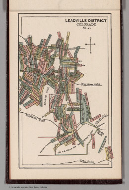
Author
Bolitho, Edwin
Full Title
Leadville District, Colorado. No. 1. (to accompany) Pocket Mining Atlas. Compiled From The Latest Official Surveys, And The Most Authentic Sources. Edwin Bolitho, Engineering and Mining Journal, New York, 1880. Price, $1.00 per copy. (on following page) Entered ... 1880 ... Washington, D.C., by Trask & Francis, Bankers ... 70 Broadway, New York ...
Publisher
Edwin Bolitho, Engineering and Mining Journal
Author
Bolitho, Edwin
Full Title
Leadville District, Colorado. No. 2. (to accompany) Pocket Mining Atlas. Compiled From The Latest Official Surveys, And The Most Authentic Sources. Edwin Bolitho, Engineering and Mining Journal, New York, 1880. Price, $1.00 per copy. (on following page) Entered ... 1880 ... Washington, D.C., by Trask & Francis, Bankers ... 70 Broadway, New York ...
Publisher
Edwin Bolitho, Engineering and Mining Journal
Author
Bolitho, Edwin
Full Title
Central City District, Col. (to accompany) Pocket Mining Atlas. Compiled From The Latest Official Surveys, And The Most Authentic Sources. Edwin Bolitho, Engineering and Mining Journal, New York, 1880. Price, $1.00 per copy. (on following page) Entered ... 1880 ... Washington, D.C., by Trask & Francis, Bankers ... 70 Broadway, New York ...
Publisher
Edwin Bolitho, Engineering and Mining Journal
Author
Bolitho, Edwin
Full Title
Silver Cliff District, Colorado. (to accompany) Pocket Mining Atlas. Compiled From The Latest Official Surveys, And The Most Authentic Sources. Edwin Bolitho, Engineering and Mining Journal, New York, 1880. Price, $1.00 per copy. (on following page) Entered ... 1880 ... Washington, D.C., by Trask & Francis, Bankers ... 70 Broadway, New York ...
Publisher
Edwin Bolitho, Engineering and Mining Journal
Author
Bolitho, Edwin
Full Title
Map of Caribou Hill, Grand Island Mining District, Boulder County, Colorado. (to accompany) Pocket Mining Atlas. Compiled From The Latest Official Surveys, And The Most Authentic Sources. Edwin Bolitho, Engineering and Mining Journal, New York, 1880. Price, $1.00 per copy. (on following page) Entered ... 1880 ... Washington, D.C., by Trask & Francis, Bankers ... 70 Broadway, New York ...
Publisher
Edwin Bolitho, Engineering and Mining Journal
Author
Colton. G.W. & C.B.
Full Title
(Covers to) Colton's Sectional & Topographical Map of Colorado. Published by G.W. & C.B. Colton & Co. 172 William St. New York. 1871. Entered ... 1871 by G.W. & C.B. Colton & Co. ... Washington.
Publisher
G.W. & C.B. Colton
|