Who What Where WhenREMOVEWHO
WHEN
|
Author
Warren, Gouverneur Kemble, 1830-1882
Full Title
Map Of The Territory Of The United States From The Mississippi To The Pacific Ocean Ordered by the Hon. Jeff'n Davis, Secretary Of War To accompany the Reports of the Explorations For A Railroad Route ... Compiled from authorized explorations and other reliable data by Lieut. G.K. Warren, Topl. Engrs. In the Office of Pacific R.R. Surveys, War Dep. under the direction of Bvt. Maj. W.H. Emory and Capt. A.A. Humphreys, Topl. Engrs. 1855. Engr. by Selmar Siebert.
Publisher
U.S.
Author
Colton, J.H.
Full Title
(Covers to) Colton's Railroad & Township Map of the State of Ohio. Published By Johnson & Browning, No. 172 William St. New York. 1859. Entered ... 1851 by J.H. Colton ... New York. Drawn by George W. Colton. Engraved by J.M. Atwood, New York.
Publisher
Johnson & Browning
Author
Colton, J.H.
Full Title
Colton's Railroad & Township Map of the State of Ohio. Published By Johnson & Browning, No. 172 William St. New York. 1859. Entered ... 1851 by J.H. Colton ... New York. Drawn by George W. Colton. Engraved by J.M. Atwood, New York.
Publisher
Johnson & Browning
Author
Colton, G.W. & C.B.
Full Title
(Covers to) Map Of The Pacific Rail Road Route From The Mississippi River To The Pacific Ocean. Published By G.W. & C.B. Colton & Co. 172 William St. New York.
Publisher
G.W. & C.B. Colton & Co.
Author
Colton, G.W. & C.B.
Full Title
Map Of The Pacific Rail Road Route From The Mississippi River To The Pacific Ocean. Published By G.W. & C.B. Colton & Co. 172 William St. New York.
Publisher
G.W. & C.B. Colton & Co.
Author
[Page, H.R. & Co., Barker, J.T.]
Full Title
J.T. Barker's Railroad and Township Map of Indiana. Compiled and Engraved by H.R. Page & Co., Chicago, 1886.
Publisher
H.R. Page & Co.
Author
[Freyhold, Edward, Warren, Gouverneur Kemble, 1830-1882]
Full Title
Map Of The Territory Of The United States From The Mississippi To The Pacific Ocean; Ordered by the Hon. Jeff'n Davis, Secretary Of War To accompany the Reports of the Explorations For A Railroad Route ... Compiled from authorized explorations and other reliable data by Lieut. G.K. Warren, Topl. Engrs. In the Office of Pacific R.R. Surveys, War Dep. under the direction of Bvt. Maj. W.H. Emory, Topl. Engrs. in 1854 and of Capt. A.A. Humphreys, Topl. Engrs. 1854-5-6-7-8. Drawn by E. Freyhold. Engr. on Stone by J. Bien, 60 Fulton St. N.Y.
Publisher
U.S.
Author
Warren, Gouverneur Kemble, 1830-1882
Full Title
Map Of The Territory Of The United States From The Mississippi River To The Pacific Ocean; Originally prepared to accompany the Reports of the Explorations For A Pacific Railroad Route ... Compiled from authorized explorations and other reliable data by Lieut. G.K. Warren, Top'l. Eng'rs. In the Office of Pacific R.R. Surveys, War Dept. under the direction of Bvt. Maj. W.H. Emory, Top'l. Eng'rs. in 1854. Capt. A.A. Humphreys, Top'l. Eng'rs. in 1854-58. And partly recompiled and redrawn under the direction of the Engineer Bureau in 1865-66-67. Engineer Bureau, War Department. Engraved on stone by Julius Bien, New York.
Publisher
Julius Bien
Author
[Freyhold, Edward, Warren, Gouverneur Kemble, 1830-1882]
Full Title
Territory Of The United States From The Mississippi River To The Pacific Ocean; Originally prepared to accompany the Reports of the Explorations For A Pacific Railroad Route ... Compiled from authorized explorations and other reliable data by Lieut. G.K. Warren, Top'l. Eng'rs. In the Office of Pacific R.R. Surveys, War Dept. under the direction of Bvt. Maj. W.H. Emory, Top'l. Eng'rs. in 1854. Capt. A.A. Humphreys, Top'l. Eng'rs. in 1854-58. Recompiled and redrawn under the direction of the Chief of Corps of Engineers By Edward Freyhold 1865-66-67-68. Head Quarters Corp Of Engineers, War Department. Engraved & printed by Julius Bien, N.Y. (inset) Territory Of Alaska Ceded By Russia To The United States 1868.
Publisher
Julius Bien
Author
[Pacific Railroad Survey, Warren, Gouverneur Kemble, 1830-1882]
Full Title
(Title Page to) Reports of Explorations and Surveys, to Ascertain the Most Practicable and Economical Route for a Railroad From the Mississippi River to the Pacific Ocean. Made Under the Direction of the Secretary of War, In 1853-56, According to Acts of Congress of March 3, 1853, May 31, 1854, and August 5, 1854. Volume XI. Washington: George W. Bowman, Printer. 1861. 36th Congress, 2d Session, Senate, Ex. Doc.
Publisher
[A.O.P. Nicholson I-XI, T. Ford XII.]
Author
[Andreas, A. T. (Alfred Theodore), 1839-1900, Baskin, Forster and Company]
Full Title
New railroad map of the United States and Dominion of Canada. (Published by Baskin, Forster & Co. Lakeside Building Chicago, Ills. 1876. Engraved & Printed by Chas. Shober & Co. Props. of Chicago Lithographing Co.)
Publisher
Baskin, Forster & Co.
Author
[Pacific Railroad Survey, Warren, Gouverneur Kemble, 1830-1882]
Full Title
(Title Page to) Topographical maps, profiles, and sketches to illustrate the various Reports of Surveys for railroad routes from the Mississippi River to the Pacific Ocean. Washington, D.C., 1861.
Publisher
[A.O.P. Nicholson I-XI, T. Ford XII.]
Author
Everts, L.H.
Full Title
Rail Road Map of the United States. Prepared Expecially for Evert's Illustrated Historical Atlas by H.H. Lloyd & Co..21 John St., N.Y.
Publisher
L.H. Everts
Author
Colton, G.W. & C.B.
Full Title
(Covers to) Colton's Railroad & Township Map Of The State Of New York, With Parts of the Adjoining States & Canada. Published by G.W. And C.B. Colton & Co. No. 172 William St. New York 1868. Entered ... 1852, by J.H. Colton ... N. York. Drawn by Geo. W. Colton.
Publisher
G.W. & C.B. Colton & Co.
Author
Colton, G.W. & C.B.
Full Title
Colton's Railroad & Township Map Of The State Of New York, With Parts of the Adjoining States & Canada. Published by G.W. And C.B. Colton & Co. No. 172 William St. New York 1868. Entered ... 1852, by J.H. Colton ... N. York. Drawn by Geo. W. Colton.
Publisher
G.W. & C.B. Colton & Co.
Author
Cram, George
Full Title
Cram's Superior Map Of California Showing Distances between Railroad Stations, and Populations by Decimals of all Cities and Villages with 100 Inhabitants and over. A Concise and Ready Reference Index ... George F. Cram, Engraver and Publisher Established 1867. 130 Fulton Street, New York. 55 to 61 Market Street, Chicago. Price $3.00. Copyright, 1908, by George F. Cram, Chicago ... Geo. F. Cram, Engraver, Chicago. (inset) Vicinity Of San Francisco, Oakland, Sacramento, San Jose, Stockton. George F. Cram, Engr. & Pub. Chicago, Ill. (with 3 additional inset maps).
Publisher
George F. Cram
Author
Railroad Commission of the State of California
Full Title
1926 Edition Of The Official Railroad Map Of California. Issued by Railroad Commission Of The State Of California. State Building, San Francisco ... Compiled by the Railroad Commission of the State of California, Engineering Department, Lester S. Ready, Chief Engineer. J.W. Clement Co., Buffalo, N.Y. (with 4 inset maps).
Publisher
J.W. Clement
Author
Barnes, R.L.
Full Title
County, Township & Railroad Map Of The State Of Pennsylvania. Philadelphia, Published By R.L. Barnes No. 7 Hart's Building 6th above Chestnut St. 1857. Entered ... 1856 by R.L. Barnes ... Pennsylvania.
Publisher
R.L. Barnes
Author
Rand McNally and Company
Full Title
New County And Railway Map Of The United States And The Dominion Of Canada Compiled From Information Obtained From Official Sources Showing The Lines Of The Chicago And Alton R.R. And Its Connections ... Rand, McNally & Co., Map Publishers and Engravers, Chicago. Copyright, 1883, by Rand, McNally & Co. ...
Publisher
Rand McNally and Company
Author
Knight, Edward H.
Full Title
Map Of The Country Tributary To The Northern Pacific Railroad. Compiled from English, Canadian, and American official sources and original Surveys by Edward H. Knight. Jan. 1st. 1871. The compilation of English and Canadian charts and Surveys embracing the Northerly region of this Map, was platted in connection with the official U.S. War Department Map (the lower portion) at the Bureau of U.S. Topographical Engineers by the kind permission of Maj. Gen. A.A. Humphreys. (with profile).
Publisher
No Publisher
Author
[Everts & Co., L.H. Everts & Co.]
Full Title
Building of Neosho Investment Company ... (with) Public school building, 1st Ward ... (with) Missouri Pacific stock yards ... (with) Union Depot, Missouri Pacific round house, yards, &c. (all) Chetopa, Kansas. (L.H. Everts & Co., publishers, Philadelphia, 1887)
Publisher
L.H. Everts & Co.
Author
[Union Pacific Railroad, Dodge, G.M.]
Full Title
Map of the Union Pacific Rail Road Surveys of 1864, 65, 66, 67, 1868 from Missouri River to Humboldt Wells Scale 20 miles to 1 inch. G.M. Dodge, Chief Engineer. H. Lambach, del. January 1869. (with profile) Profile Of Grades.
Publisher
Union Pacific Railroad Company
Author
Murray, J. Morrison
Full Title
Murray's Matchless Historical County, Railroad, Distance And Index Map Of The United States And Illustrated Reference Map Of The World. J. Morrison Murray, Publisher. Elizabeth, New Jersey. 1883. Copyrighted 1882. Price $4.00 ... (on verso) The Illustrated Reference Map Of The World, For Students, Business Men and Families ... Published By J.M. Murray ... (with 3 large inset maps).
Publisher
J. Morrison Murray
Author
[Desilver, Charles, Young, James H.]
Full Title
(Covers to) A New Map Of The State Of Virginia Exhibiting Its Internal Improvements Roads Distances &c. by J.H. Young. Philadelphia: Published By Charles DeSilver 714 Chestnut St. 1859. Entered ... 1856 by Charles Desilver ... Pennsylvania. (inset) District Of Columbia.
Publisher
Charles Desilver.
Author
[Desilver, Charles, Young, James H.]
Full Title
A New Map Of The State Of Virginia Exhibiting Its Internal Improvements Roads Distances &c. by J.H. Young. Philadelphia: Published By Charles DeSilver 714 Chestnut St. 1859. Entered ... 1856 by Charles Desilver ... Pennsylvania. (inset) District Of Columbia.
Publisher
Charles Desilver.
Author
[Kollner, Augustus, Sunbury and Erie Railroad]
Full Title
Pennsylvania's Great Highway And Its Tributary Lines. Engraved & printed at A. Kollner's Litho Establisht. cor. of Secd. & Dock Sts. Phila.
Publisher
A. Kollner's Litho Establishment
Author
[Götz, Antonín, Československá akademie věd., Czechoslovakia. Ústřední správa geodézie a kartografie.]
Full Title
Railway and Water Transport.
Publisher
Czechoslovakia. Ústřední správa geodézie a kartografie.
Author
[Götz, Antonín, Československá akademie věd., Czechoslovakia. Ústřední správa geodézie a kartografie.]
Full Title
Railway Goods Traffic and Communications.
Publisher
Czechoslovakia. Ústřední správa geodézie a kartografie.
Author
Goldthwait, J.H.
Full Title
(Covers to) Goldthwait's Map Of The United States, British Provinces, Mexico, Central America, W. India Is. &c. Exhibiting The Railroads ... by J.H. Goldthwait. Published by D. Chester, 119 & 121 Nassau St. New York. Entered ... 1861 by J.H. Goldthwait ... New York. (inset) Great Rail Road Routes from the Middle Atlantic Ports To The Mississippi River by J.H. Goldthwait. (inset) Of The Railroads Of New England And Eastern N . York by J.H. Goldthwait.
Publisher
D. Chester
Author
Goldthwait, J.H.
Full Title
Goldthwait's Map Of The United States, British Provinces, Mexico, Central America, W. India Is. &c. Exhibiting The Railroads ... by J.H. Goldthwait. Published by D. Chester, 119 & 121 Nassau St. New York. Entered ... 1861 by J.H. Goldthwait ... New York. (inset) Great Rail Road Routes from the Middle Atlantic Ports To The Mississippi River by J.H. Goldthwait. (inset) Of The Railroads Of New England And Eastern N . York by J.H. Goldthwait.
Publisher
D. Chester
Author
Perris, William
Full Title
(Covers to) A New And Complete Rail Road Map Of The United States, Compiled from Reliable Sources by William Perris, C.E. & Surveyor, New York. Presented by the Home Insurance Company of New York ... Office Nos. 112 & 114 Broadway ... Korff Brothers Practical Lithographers 54 William St. New York.
Publisher
Korff Brothers
Author
Perris, William
Full Title
A New And Complete Rail Road Map Of The United States, Compiled from Reliable Sources by William Perris, C.E. & Surveyor, New York. Presented by the Home Insurance Company of New York ... Office Nos. 112 & 114 Broadway ... Korff Brothers Practical Lithographers 54 William St. New York.
Publisher
Korff Brothers
Author
[Colton, J.H., Parker, Nathan H.]
Full Title
(Covers to) Parker's Sectional & Geological Map Of Iowa. Exhibiting her Iron Lead Copper Coal and other Geological Resources And All Rail Roads Completed, in progress, and projected. Compiled from the U.S. Surveys and personal reconnoisance. By Nathan H. Parker. Author of "Iowa As It Is" Clinton Io. 1856. J.H. Colton & Co. 172 William St. New York. D.B. Cooke & Co. Chicago Ill. Entered ... 1856, by N.H. Parker... Iowa. Engraved, Printed And Mounted By J.H. Colton & Co. 172 William Street, New York. (inset) Map Showing the Connections between the Iowa And Eastern Rail Roads.
Publisher
[D.B. Cooke, J.H. Colton]
Author
[Colton, J.H., Parker, Nathan H.]
Full Title
Parker's Sectional & Geological Map Of Iowa. Exhibiting her Iron Lead Copper Coal and other Geological Resources And All Rail Roads Completed, in progress, and projected. Compiled from the U.S. Surveys and personal reconnoisance. By Nathan H. Parker. Author of "Iowa As It Is" Clinton Io. 1856. J.H. Colton & Co. 172 William St. New York. D.B. Cooke & Co. Chicago Ill. Entered ... 1856, by N.H. Parker... Iowa. Engraved, Printed And Mounted By J.H. Colton & Co. 172 William Street, New York. (inset) Map Showing the Connections between the Iowa And Eastern Rail Roads.
Publisher
[J.H. Colton, D.B. Cooke]
Author
Colton, J.H.
Full Title
(Covers to) Colton's Railroad & Township Map Of The State Of New York, With Parts of the Adjoining States & Canada. Published by J.H. Colton & Co. No. 172 William St. New York 1855. Entered ... 1852, by J.H. Colton ... N. York. Drawn by Geo. W. Colton. J.M. Atwood Sculpt.
Publisher
J.H. Colton & Co.
Author
Colton, J.H.
Full Title
Colton's Railroad & Township Map Of The State Of New York, With Parts of the Adjoining States & Canada. Published by J.H. Colton & Co. No. 172 William St. New York 1855. Entered ... 1852, by J.H. Colton ... N. York. Drawn by Geo. W. Colton. J.M. Atwood Sculpt.
Publisher
J.H. Colton & Co.
Author
Poole Brothers
Full Title
(Covers to) Map Of The Mexican Central Railway And Connections. May, 1898.
Publisher
Poole Bros.
Author
Poole Brothers
Full Title
(Frontispiece to) Map Of The Mexican Central Railway And Connections. May, 1898.
Publisher
Poole Bros.
Author
Poole Brothers
Full Title
Map Of The Mexican Central Railway And Connections. May, 1898.
Publisher
Poole Bros.
Author
Colton, G.W. & C.B.
Full Title
(Covers to) Colton's Railroad & Commercial Atlas Of The United States, Canada Etc. Map No. 5. Michigan, Wisconsin & Minnesota. Published by G.W. & C.B. Colton. & Co. New York, 1869.
Publisher
G.W. & C.B. Colton
Author
Colton, G.W. & C.B.
Full Title
Colton's Railroad & Commercial Atlas Of The United States, Canada Etc. Map No. 5. Michigan, Wisconsin & Minnesota. Published by G.W. & C.B. Colton. & Co. New York, 1869.
Publisher
G.W. & C.B. Colton
Author
Hardee, T.S.
Full Title
(Covers to) Hardee's Geographical, Historical and Statistical Official Map Of Mississippi Embracing Portions Of Alabama, Arkansas, Louisiana And Tennessee, From Recent Surveys And Investigations And Officially Compiled Under Authority From The State Legislature By T.S. Hardee State Engineer A.D. 1872. Hugh Lewis, Lithographer And Publisher - New Orleans, LA. Entered ... 1872 By T.S. Hardee ... At Washington. G. Koeckert. Engraver. (inset) Rail Road And Geological Map Of Mississippi. (inset) Profile of Grades New Orleans, Jackson And Great Northern Rail Road... (insets) Statistical tables and Historical information.
Publisher
Hugh Lewis
Author
Hardee, T.S.
Full Title
Hardee's Geographical, Historical and Statistical Official Map Of Mississippi Embracing Portions Of Alabama, Arkansas, Louisiana And Tennessee, From Recent Surveys And Investigations And Officially Compiled Under Authority From The State Legislature By T.S. Hardee State Engineer A.D. 1872. Hugh Lewis, Lithographer And Publisher - New Orleans, LA. Entered ... 1872 By T.S. Hardee ... At Washington. G. Koeckert. Engraver. (inset) Rail Road And Geological Map Of Mississippi. (inset) Profile of Grades New Orleans, Jackson And Great Northern Rail Road... (insets) Statistical tables and Historical information.
Publisher
Hugh Lewis
Author
Lloyd, J.T.
Full Title
(Covers to) Lloyd's New Map of the United States The Canadas And New Brunswick From the latest Surveys Showing Every Railroad & Station Finished to June 1863 And The Atlantic And Gulf Coasts ... 1863 ... Address J.T. Lloyd, No. 164 Broadway, New York, and 1 Strand, London, England. Entered ... 1863, by J.T. Lloyd ... New York.
Publisher
J.T. Lloyd
Author
Lloyd, J.T.
Full Title
Lloyd's New Map of the United States The Canadas And New Brunswick From the latest Surveys Showing Every Railroad & Station Finished to June 1863 And The Atlantic And Gulf Coasts ... 1863 ... Address J.T. Lloyd, No. 164 Broadway, New York, and 1 Strand, London, England. Entered ... 1863, by J.T. Lloyd ... New York.
Publisher
J.T. Lloyd
Author
[Cram, George, Farrington, E.C.]
Full Title
(Covers to) Map Of The State Of Maine Showing Railroads, Towns, Plantations and Wild Lands. 1900. 61-63 Plymouth Place, Chicago, Ill. 130 Fulton Street, New York. Revised By Frank E. Oak, State Land Office, Augusta, Me. Copyright 1900 By E.C. Farrington, Augusta, Maine. (with 36 page index) Farrington's Map Of Maine, Together with the Index and Appendix Of Information ... E.C. Farrington, Augusta, Maine.
Publisher
E.C. Farrington
Author
[Cram, George, Farrington, E.C.]
Full Title
(Title Page to) Farrington's Map Of Maine, Together with the Index and Appendix Of Information ... E.C. Farrington, Augusta, Maine. (on verso) Index to State Map Of Maine. (with) Map Of The State Of Maine Showing Railroads, Towns, Plantations and Wild Lands. 1900. 61-63 Plymouth Place, Chicago, Ill. 130 Fulton Street, New York. Revised By Frank E. Oak, State Land Office, Augusta, Me. Copyright 1900 By E.C. Farrington, Augusta, Maine.
Publisher
E.C. Farrington
Author
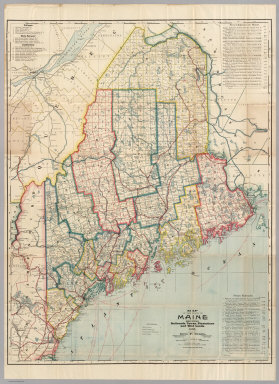
[Cram, George, Farrington, E.C.]
Full Title
Farrington's Map Of Maine, Together with the Index and Appendix Of Information ... E.C. Farrington, Augusta, Maine. (on verso) Index to State Map Of Maine. (with) Map Of The State Of Maine Showing Railroads, Towns, Plantations and Wild Lands. 1900. 61-63 Plymouth Place, Chicago, Ill. 130 Fulton Street, New York. Revised By Frank E. Oak, State Land Office, Augusta, Me. Copyright 1900 By E.C. Farrington, Augusta, Maine.
Publisher
E.C. Farrington
Author
Colton, G.W. & C.B.
Full Title
(Covers to) Colton's Map Of The Middle States Showing The Counties, Towns, Railroads, and Stations. Published By G.W. And C.B. Colton & Co. 172 William St. New York. 1874. Entered ... 1872 by G.W. & C.B. Colton & Co. ... Washington.
Publisher
G.W. & C.B. Colton
Author
Colton, G.W. & C.B.
Full Title
Colton's Map Of The Middle States Showing The Counties, Towns, Railroads, and Stations. Published By G.W. And C.B. Colton & Co. 172 William St. New York. 1874. Entered ... 1872 by G.W. & C.B. Colton & Co. ... Washington.
Publisher
G.W. & C.B. Colton
|