|
|
Author
[Official Airline Guide, Texaco Inc.]
Full Title
Airline Map of the United States, 1960.
Publisher
Texaco Inc.
Author
Warren, Gouverneur Kemble, 1830-1882
Full Title
Map Of The Territory Of The United States From The Mississippi To The Pacific Ocean Ordered by the Hon. Jeff'n Davis, Secretary Of War To accompany the Reports of the Explorations For A Railroad Route ... Compiled from authorized explorations and other reliable data by Lieut. G.K. Warren, Topl. Engrs. In the Office of Pacific R.R. Surveys, War Dep. under the direction of Bvt. Maj. W.H. Emory and Capt. A.A. Humphreys, Topl. Engrs. 1855. Engr. by Selmar Siebert.
Publisher
U.S.
Author
[Freyhold, Edward, Warren, Gouverneur Kemble, 1830-1882]
Full Title
Map Of The Territory Of The United States From The Mississippi To The Pacific Ocean; Ordered by the Hon. Jeff'n Davis, Secretary Of War To accompany the Reports of the Explorations For A Railroad Route ... Compiled from authorized explorations and other reliable data by Lieut. G.K. Warren, Topl. Engrs. In the Office of Pacific R.R. Surveys, War Dep. under the direction of Bvt. Maj. W.H. Emory, Topl. Engrs. in 1854 and of Capt. A.A. Humphreys, Topl. Engrs. 1854-5-6-7-8. Drawn by E. Freyhold. Engr. on Stone by J. Bien, 60 Fulton St. N.Y.
Publisher
U.S.
Author
[U.S. North West Boundary Survey, Campbell, Archibald]
Full Title
Sheet No. 1. Photo-Lithographic Copy Of The Detailed Maps Of The North West Boundary ...Between The United States And The British Possessions Under the Treaty of June 15th 1846. (A-kwote-katl-nam Lake to Kootenay River, Washington Territory and British Columbia).
Publisher
Julius Bien
Author
[U.S. North West Boundary Survey, Campbell, Archibald]
Full Title
Sheet No. 2. Photo-Lithographic Copy Of The Detailed Maps Of The North West Boundary ...Between The United States And The British Possessions Under the Treaty of June 15th 1846. (Kootenay River to Camp Kootenay W., Washington Territory and British Columbia).
Publisher
Julius Bien
Author
[U.S. North West Boundary Survey, Campbell, Archibald]
Full Title
Sheet No. 3. Photo-Lithographic Copy Of The Detailed Maps Of The North West Boundary ...Between The United States And The British Possessions Under the Treaty of June 15th 1846. (Camp Kootenay W. to Camp Columbia and Yome-tsin Creek, Washington Territory and British Columbia).
Publisher
Julius Bien
Author
[U.S. North West Boundary Survey, Campbell, Archibald]
Full Title
Sheet No. 4. Photo-Lithographic Copy Of The Detailed Maps Of The North West Boundary ...Between The United States And The British Possessions Under the Treaty of June 15th 1846. (Little Dalles and Yome-tsin Creek to Rock Creek, Washington Territory and British Columbia).
Publisher
Julius Bien
Author
[U.S. North West Boundary Survey, Campbell, Archibald]
Full Title
Sheet No. 5. Photo-Lithographic Copy Of The Detailed Maps Of The North West Boundary ...Between The United States And The British Possessions Under the Treaty of June 15th 1846. (Camp O-so-yoos and O-so-yoos Lake to Camp Pa-say-ten, Washington Territory and British Columbia).
Publisher
Julius Bien
Author
[U.S. North West Boundary Survey, Campbell, Archibald]
Full Title
Sheet No. 6. Photo-Lithographic Copy Of The Detailed Maps Of The North West Boundary ...Between The United States And The British Possessions Under the Treaty of June 15th 1846. (Camp Pa-say-ten to Chiloweyuck River, Washington Territory and British Columbia).
Publisher
Julius Bien
Author
[U.S. North West Boundary Survey, Campbell, Archibald]
Full Title
Sheet No. 7. (Sheet with Title). Photo-Lithographic Copy Of The Detailed Maps Of The North West Boundary ...Between The United States And The British Possessions Under the Treaty of June 15th 1846. (Chiloweyuck River to Point Roberts, Washington Territory and British Columbia).
Publisher
Julius Bien
Author
Burr, David H.
Full Title
Map of the United States, Exhibiting the Several Collection Districts. Senate Ex. Doc. No. 77. Drawn by David H. Burr. Draftsman U.S. Senate. Ackerman Lith. 379 Broadway, N.Y.
Publisher
Ackerman Litho.
Author
Rand McNally and Company
Full Title
New County And Railway Map Of The United States And The Dominion Of Canada Compiled From Information Obtained From Official Sources Showing The Lines Of The Chicago And Alton R.R. And Its Connections ... Rand, McNally & Co., Map Publishers and Engravers, Chicago. Copyright, 1883, by Rand, McNally & Co. ...
Publisher
Rand McNally and Company
Author
[Lloyd, James T., Lloyd, E.]
Full Title
Lloyd's Topographical Map Of America 1871. Projected By J.T. Lloyd. E. Lloyd, Publisher, New York, Cortlandt St., London, 83 Fleet St. Entered ... 1865 by J.T. Lloyd ... New York ...
Publisher
E. Lloyd
Author
[Oil and Gas Journal, Petroleum Publishing Company]
Full Title
The Oil and Gas Journal, Producing, Refining, Marketing, Map of Oil Trunk Pipe Lines With Locations of Refineries Shown by Circles. (Copyright 1926 by the Petroleum Publishing Company, Tulsa, Okla.) ... Crude oil is transported through pipe lines at an average rate of four miles an hour.
Publisher
Petroleum Publishing Company
Author
Thompson, Kenneth W.
Full Title
The Americas Served by American Republic Lines ; Grace Line ; Pan American Airways System Pan American-Grace Airways ; United Fruit Company. (by) Kenneth W. Thompson. Printed in U.S.A.
Publisher
No publisher
Author
Olney, Jesse, 1798-1872.
Full Title
Olney's Outline Maps, for Common Schools and General Use. United States ; Ext.2,600,000 Sq. Miles. Population 20 Mil. New York, Pratt, Woodford and Co. Entered according to Act of Congress in ... 1847, by Pratt Woodford ... Southern District of New York.
Publisher
Pratt Woodford
Author
Rand McNally & Co.
Full Title
Rand McNally & Co.'s new railway guide map. Printed expressly for J. Bride & Co.'s Great American 25 Cent package, 767 and 769 Broadway, New York City. A.W. Barber, Del. Rand McNally & Co. Printers, engravers and electrotypers, 79 Madison Street, Chicago. (with 2 insets). (on verso) Rand McNally & Co.'s sectional map of the Dakota and the Black Hills.
Publisher
Rand McNally & Co.
Author
Breese, Sidney
Full Title
Skeleton Map Showing the Railroads completed and in Progress in the United States, and those projected through the Public Lands and their connection with the principal Harbours on the Lakes and on the Seaboard. Printed by order of the Senate of the United States the 9th Sess: 31st Congress 1848-9. Accompanied with a report from Hon. Sidney Breese, for granting land to the State if Illinois to aid in the completion of her rail roads. C.B. Graham's Lithy. Washington City, D.C. (to accompany) Report: In Senate of the United States. December 19, 1848.
Publisher
C.B. Graham's Lithy.
Author
Richard, Albert
Full Title
Albert Richard Football map. Copyright 1938, Albert Richard Co. Milwaukee, Wis. F.R. Cheeseman.
Publisher
Albert Richard Company
Author
Bolton, Herbert Eugene, 1870-1953.
Full Title
Explorations on the northern frontier of New Spain 1535-1706 : compiled by Herbert Bolton 1915 ; H.B. Foster, del.
Publisher
University of California Press
Author
[Tardieu, P.A.F., Lapie, Pierre, Piquet, Chles.]
Full Title
A Map of the United States, Canada, New-Scotland, New-Brunswick and New-Foundland ... Carte Des Etats - Unis, Avec Le Canada, la Nouvelle Ecosse, le Nouveau Brunswick & Terre - Neuve. A Map of the West-Indies and the Mexican Gulph (Gulf) ...Carte Des Indes Occientale et du Golfe du Mexique... Dressee par Lapie, Capitaine-Ingenieur-Geographe. Publiee par P.A.F. Tardieu, Gravveur, Editeur-proprietaire, a Paris, Chez P.A.F. Tardieu ....
Publisher
Chez P.A.F. Tardieu
Author
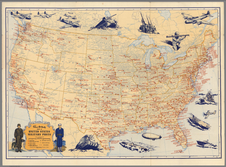
Rand McNally & Co.
Full Title
Rand McNally Map of United States Military Posts.
Publisher
Rand McNally & Co.
Author
[National Wholesale Druggists' Association, Newcomb, Edwin]
Full Title
Medicinal plant map of the United States of America. Published by the National Wholesale Druggists' Association ; under the direction of Chairman Geo. Van Gorder ... edited by Dr. Edwin L. Newcomb ... with the assistance of Dr. Heber W. Youngken ... and Willard W. Eggleston ... Bureau of plant Industry, United States Department of Agriculture. September, 1932. Einson-Freeman Co. Inc. L.I. City New York. Litho. in U.S.A. (Text on verso) List of chemicals used in the practice of medicine and pharmacy in America ...
Publisher
[National Wholesale Druggists' Association, Einson-Freeman Co., inc,]
Author
Greyhound Lines
Full Title
A good-natured map of the United States setting forth the services of The Greyhound Lines and a few principal connecting bus lines.
Publisher
The Greyhound Lines
Author
Byron Weston Company
Full Title
A Map of Air Mail & Passenger Routes. Prepared by Byron Weston Company, Manufacturers of Highest Grade Record and Ledger Papers. Dalton, Massachusetts and Printed on Weston's Linen Ledger. (c) B.W. Co. 1930.
Publisher
Byron Weston Company
Author
Greyhound Lines
Full Title
Transcontinental routes of Pacific Greyhound Lines : Also Pickwick -Greyhound and Greyhound Lines. "Over 35,000 miles of scenic highway routes ..."
Publisher
The Greyhound Lines
Author
Freyhold, Edward; Warren, Gouverneur Kemble, 1830-1882
Full Title
(NW Sheet to) Territory Of The United States From The Mississippi River To The Pacific Ocean; Originally prepared to accompany the Reports of the Explorations For A Pacific Railroad Route ... Compiled from authorized explorations and other reliable data by Lieut. G.K. Warren, Top'l. Eng'rs. In the Office of Pacific R.R. Surveys, War Dept. under the direction of Bvt. Maj. W.H. Emory, Top'l. Eng'rs. in 1854. Capt. A.A. Humphreys, Top'l. Eng'rs. in 1854-58. Recompiled and redrawn under the direction of the Chief of Corps of Engineers By Edward Freyhold 1865-66-67-68. Head Quarters Corp Of Engineers, War Department. Engraved & printed by Julius Bien, N.Y. (inset) Territory Of Alaska Ceded By Russia To The United States 1868.
Publisher
Julius Bien
Author
Freyhold, Edward; Warren, Gouverneur Kemble, 1830-1882
Full Title
(SW Sheet to) Territory Of The United States From The Mississippi River To The Pacific Ocean; Originally prepared to accompany the Reports of the Explorations For A Pacific Railroad Route ... Compiled from authorized explorations and other reliable data by Lieut. G.K. Warren, Top'l. Eng'rs. In the Office of Pacific R.R. Surveys, War Dept. under the direction of Bvt. Maj. W.H. Emory, Top'l. Eng'rs. in 1854. Capt. A.A. Humphreys, Top'l. Eng'rs. in 1854-58. Recompiled and redrawn under the direction of the Chief of Corps of Engineers By Edward Freyhold 1865-66-67-68. Head Quarters Corp Of Engineers, War Department. Engraved & printed by Julius Bien, N.Y. (inset) Territory Of Alaska Ceded By Russia To The United States 1868.
Publisher
Julius Bien
Author
Freyhold, Edward; Warren, Gouverneur Kemble, 1830-1882
Full Title
(SE Sheet to) Territory Of The United States From The Mississippi River To The Pacific Ocean; Originally prepared to accompany the Reports of the Explorations For A Pacific Railroad Route ... Compiled from authorized explorations and other reliable data by Lieut. G.K. Warren, Top'l. Eng'rs. In the Office of Pacific R.R. Surveys, War Dept. under the direction of Bvt. Maj. W.H. Emory, Top'l. Eng'rs. in 1854. Capt. A.A. Humphreys, Top'l. Eng'rs. in 1854-58. Recompiled and redrawn under the direction of the Chief of Corps of Engineers By Edward Freyhold 1865-66-67-68. Head Quarters Corp Of Engineers, War Department. Engraved & printed by Julius Bien, N.Y. (inset) Territory Of Alaska Ceded By Russia To The United States 1868.
Publisher
Julius Bien
Author
Freyhold, Edward; Warren, Gouverneur Kemble, 1830-1882
Full Title
(NE Sheet to) Territory Of The United States From The Mississippi River To The Pacific Ocean; Originally prepared to accompany the Reports of the Explorations For A Pacific Railroad Route ... Compiled from authorized explorations and other reliable data by Lieut. G.K. Warren, Top'l. Eng'rs. In the Office of Pacific R.R. Surveys, War Dept. under the direction of Bvt. Maj. W.H. Emory, Top'l. Eng'rs. in 1854. Capt. A.A. Humphreys, Top'l. Eng'rs. in 1854-58. Recompiled and redrawn under the direction of the Chief of Corps of Engineers By Edward Freyhold 1865-66-67-68. Head Quarters Corp Of Engineers, War Department. Engraved & printed by Julius Bien, N.Y. (inset) Territory Of Alaska Ceded By Russia To The United States 1868.
Publisher
Julius Bien
Author
Lloyd, James T.
Full Title
Lloyd's American railroad map of the United States, showing the three proposed roads and the overland mail route to the Pacific 1859. Drawn and engraved by Rae Smith, 71 Nassau St. N.Y. From materials furnished to the 36th Congress, March 1859 by G.K. Warren, Lt. U.S. Top. Eng. for the passage of the Pacific Railroad Bill. Entered ... 1859, by J.T. Lloyd ... Pensylvania.
Publisher
J.T. Lloyd
Author
Chase, Ernest Dudley, 1878-1966
Full Title
The pictorial map : United States Stamps. Designed, drawn and published by Ernest Dudley Chase. Winchester, Mass.; Research directors Charles Peck Kerr and Rupert Frank Jones. The post : Artists: Famous American Commemorative Series -- 1940.
Publisher
Ernest Dudley Chase.
Author
[Bauer Hubert A., Air-Age Education Research]
Full Title
World around the United States : Map of proposed world air routes : for United States flag carriers airline time-distance chart and chronological history of the progress of aviation; Developed by Air-Age Educational Research. H.A. Bauer, Cartographer - Copyright by American Airlines, Inc. Second edition - Printed in U.S.A. - Published in January 1946. contributed by American Airlines System ... and distributed as a Teacher service by Young America. (with inset).
Publisher
Air-Age Education Research
Author
Paine, Paul M.
Full Title
Map of America's making : a chart of places and events for those who would sail with the discoverers, seek freedom with the colonists, follow the westward trails, subdue the wilderness, and behold the building of the Republic. F. Haase. Copyright by Paul M. Paine, 1925 - 1926 - 1929 - 1939. R.R. Bowker Company. 62 West 45th Street, New York, N.Y. (inset) Where American History began [Northeast.].
Publisher
R.R. Bowker Co.
Author
Ensign & Thayer
Full Title
Map Of The United States From The Latest Authorities. New York, Published By Ensign & Thayer. 50 Ann St. 1851. Entered ... 1845, by T. & E.H. Ensign ... New York. (inset) Map Of The Western Portion of the United States. (inset) Southern Part Of Florida. (inset) Map Of Oregon.
Publisher
Ensigns & Thayer
Author
Gallatin, Albert
Full Title
Carte des Tribus Indiennnes de l'Amerique du Nord : vers 1600 A.D. ;e long de l'Atlantique ; et vers 1800 A.D. a l'Ouest. D'apres un dessin Mr. Gallatin.
Publisher
No Publisher
Author
Bibliographische Institut
Full Title
Map of North America. Karte von Nordamerika. HAPAG. Bibliographische Institut AG. Leipzig. Printed in Germany.
Publisher
Bibliographische Institut AG,
Author
Paine, Paul M.
Full Title
The map of America's making : For those who would sail with Discoverers, seek Freedom with the Colonists, follow the westward trails, and behold The Building of the Republic, now in its one hundred and fiftieth year. (on lower right corner of map) PM.P. Copyright 1926; Paul M. Paine. R. R. Walker Co. 62 W. 45th St. New York N.Y.
Publisher
R.R. Bowker Co.
Author
Paine, Paul M.
Full Title
Booklovers Map of America: A Chart of Certain Landmarks of Literary Geography. Copyright 1926; Paul M. Paine. R. R. Walker Co. 62 W. 45th St. New York N.Y. (with 6 insets and location map).
Publisher
R.R. Bowker Co.
Author
Civil Aeronautics Board
Full Title
United States Air Transportation System, Routes Permanently Certified, September 30, 1953. Civil Aeronautics Board, Bureau of Air Operations, Routes and Carrier Relations.
Publisher
Civil Aeronautics Board
Author
Rand McNally & Company
Full Title
Baltimore & Ohio Railroad Geographically Correct Map of Northeastern United States.
Publisher
Rand McNally & Company
Author
Rand McNally & Company
Full Title
Geographically Correct Map of the United States Issued by Baltimore & Ohio Railroad. (insets) Alaska. Hawaii.
Publisher
Rand McNally & Company
Author
American Aviation Publications
Full Title
Airline Map of the United States 1961. Compiled by Official Airline Guide ... Copyright by American Aviation Publications, Inc.
Publisher
American Aviation Publications
Author
Chase, Ernest Dudley, 1878-1966
Full Title
The Pictorial Map, Stamps of the U.S.A. Dedicated to Philatelists Everywhere designed, drawn, and published by Ernest Dudley Chase, Winchester - Massachusetts, U.S.A.
Publisher
Chase, Ernest Dudley
Author
Anonymous
Full Title
United States.
Publisher
No Publisher
Author
Prang, L. & Co.
Full Title
Map of the Atlantic States, Showing Distances From Washington (In BeeLine) By 50 Mile Circles. (The Traveling Distance is about 1/6 to 1/3 more than the BeeLine.) (with) Map of the Battle Ground (with) Map of Norfolk Harbor, Fort Monroe, and Vicinity. (with two insets) Position of Forces at Bull Run and Fortress Monroe. Published By L. Prang & Co. - No. 84 Merchants Row, Boston, Mass. Entered ... 1861 by L. Prang & Co. ... Massachusetts.
Publisher
L. Prang & Co.
Author
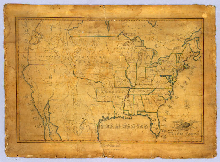
Symonds, Maria
Full Title
United States. Maria Symonds. Topsfield Academy. 1830.
Publisher
Manuscript
Author
Magnus, Charles
Full Title
Union Military Chart. Complete Map Of The Rail Roads And Water Courses In The United States & Canada. Charles Magnus & Co. ... Liverpool, New York Office No. 12 Frankfort St. ... Entered ... 1859 by Charles Magnus & Co. ... New York. (with) Military Map Of Maryland & Virginia. (with) Map Of Northern Military Movements: Between New York & St. Louis. Published by Chs. Magnus ... Entered ... 1861 by Charles Magnus ... New York. (with two small untitled maps: Pensacola Bay and United States).
Publisher
Charles Magnus
Author
[Barber, B.B., Willard, A.]
Full Title
Map Of The United States Of America With Its Territories & Districts. Including also a part of Upper & Lower Canada And Mexico. Published By B.B. Barber & A. Willard, Hartford, 1835.
Publisher
Barber and Willard
|