Who What Where WhenREMOVE |
Author
Rand McNally and Company
Full Title
(Title Page to) Rand, McNally & Co.'s Nevada. Rand, McNally & Co., Map Publishers and Engravers, Chicago, 1907. Rand, McNally & Co.'s New Business Atlas Map of Nevada. Copyright, 1907, ... 1893 ... (with 13 page index) Rand, McNally & Co.'s Indexed County And Township Pocket Map And Shippers' Guide Of Nevada ... Chicago And New York: Rand, McNally & Co. ... (on verso) Copyright, 1907, by Rand, McNally & Co., Chicago.
Publisher
Rand McNally & Co.
Author
Thompson & West
Full Title
(Title Page to) Official and historical atlas map of Alameda County, California. Compiled, drawn and published from personal examinations and surveys by Thompson & West. Oakland, Cala. 1878. Thos. Hunter Pr. Phila. N. Friend, Engr. Philad. C.L. Smith, Del.
Publisher
Thompson & West
Author
[Mitchell, Samuel Augustus, Young, James H.]
Full Title
(Title page to) Mitchell's Traveller's Guide Through The United States, Containing The Principal Cities, Towns, &c. Alphabetically Arranged; Together with the Stage, Steam-Boat, Canal and Rail-Road Routes, with the Distances, in Miles from Place to Place. Illustrated By An Accurate Map Of The United States. Philadelphia: Thomas, Cowperthwait, & Co. 253 Market Street. 78P. (on verso) Entered ... 1836, by Mitchell & Hinman ... Pennsylvania. Stereotyped by John Fagan ... Philadelphia. (with map) Mitchell's Travellers Guide Through The United States. A Map Of The Roads, Distances, Steam Boat & Canal Routes &c. By J.H. Young. Philadelphia. Published by S. Augustus Mitchell. 1843. Engraved On Steel By J.H. Young And D. Haines. Entered ... 1834 by S. Augustus Mitchell ... Pennsylvania. (with 8 inset maps).
Publisher
Thomas, Cowperthwait & Co.
Author
Sanborn-Perris Map Company, Limited
Full Title
(Title Page San Francisco Sanborn Insurance Maps.) Volume One Insurance Maps. San Francisco, California. Published by Sanborn-Perris Map Co. Limited, 115 Broadway, New York. 1899. Scale, 50 Ft. to an Inch. Copyright 1899, by the Sanborn-Perris Map Co. Limited. Contour Map of San Francisco, California, Showing the several Distributing Reservoirs of the Spring Valley Water Works and the Districts Supplied by Each ... 1899.
Publisher
Sanborn-Perris Map Company, Limited
Author
Sanborn-Perris Map Company, Limited
Full Title
(Title Page San Francisco Sanborn Insurance Map.) Volume Two Insurance Maps. San Francisco, California. Published by Sanborn-Perris Map Co. Limited, 115 Broadway, New York. 1899. Scale, 50 Ft. to an Inch. Copyright 1899, by the Sanborn-Perris Map Co. Limited.
Publisher
Sanborn-Perris Map Company, Limited
Author
Sanborn-Perris Map Company, Limited
Full Title
(Title Page San Francisco Sanborn Insurance Maps.) Volume Three Insurance Maps. San Francisco, California. Published by Sanborn-Perris Map Co. Limited, 115 Broadway, New York. 1899. Scale, 50 Ft. to an Inch. Copyright 1899, by the Sanborn-Perris Map Co. Limited.
Publisher
Sanborn-Perris Map Company, Limited
Author
Sanborn-Perris Map Company, Limited
Full Title
(Title Page to) San Francisco Sanborn Insurance Maps. Volume Four Insurance Maps. San Francisco, California. Published by Sanborn-Perris Map Co. Limited, 115 Broadway, New York. 1899. Scale, 50 Ft. to an Inch. Copyright 1899, by the Sanborn-Perris Map Co. Limited.
Publisher
Sanborn-Perris Map Company, Limited
Author
Walling, H. F.
Full Title
(Title Page to) Atlas of the State of Michigan, including statistics and descriptions of its topography, hydrology, climate, natural and civil history, railways, educational institutions, material resources, etc. By Alexander Winchell, LL.D. ... Hon. C.I. Walker, Oramel Hosford, Esq., Henry M. Utley, Esq., and Ray Haddock, Esq. Drawn, compiled, and edited by H.F. Walling, C.E. ... Published by R.M. & S.T. Tackabury, Detroit, Mich. (on verso) Entered ... 1873, by H.F. Walling ... Washington. The Claremont Manufacturing Company, Claremont, N.H., Book Manufacturers.
Publisher
R.M. & S.T. Tackabury
Author
Walling, H. F.
Full Title
(Title Page Verso to) Atlas of the State of Michigan, including statistics and descriptions of its topography, hydrology, climate, natural and civil history, railways, educational institutions, material resources, etc. By Alexander Winchell, LL.D. ... Hon. C.I. Walker, Oramel Hosford, Esq., Henry M. Utley, Esq., and Ray Haddock, Esq. Drawn, compiled, and edited by H.F. Walling, C.E. ... Published by R.M. & S.T. Tackabury, Detroit, Mich. (on verso) Entered ... 1873, by H.F. Walling ... Washington. The Claremont Manufacturing Company, Claremont, N.H., Book Manufacturers.
Publisher
R.M. & S.T. Tackabury
Author
Walling, H. F.
Full Title
(Contents to) Atlas of the State of Michigan, including statistics and descriptions of its topography, hydrology, climate, natural and civil history, railways, educational institutions, material resources, etc. By Alexander Winchell, LL.D. ... Hon. C.I. Walker, Oramel Hosford, Esq., Henry M. Utley, Esq., and Ray Haddock, Esq. Drawn, compiled, and edited by H.F. Walling, C.E. ... Published by R.M. & S.T. Tackabury, Detroit, Mich. (on verso) Entered ... 1873, by H.F. Walling ... Washington. The Claremont Manufacturing Company, Claremont, N.H., Book Manufacturers.
Publisher
R.M. & S.T. Tackabury
Author
Becker, George F.
Full Title
(Title Page to) Department Of The Interior, United States Geological Survey, Clarence King Director. Atlas To Accompany The Monograph On The Geology Of The Comstock Lode And The Washoe District By George F. Becker. Washington 1882. Julius Bien & Co. Lith. New York.
Publisher
Julius Bien & Co.
Author
Mitchell, Samuel Augustus
Full Title
(Title Page to) A New Universal Atlas Containing Maps of the various Empires, Kingdoms, States and Republics Of The World. With a special map of each of the United States, Plans of Cities &c. Comprehended in seventy five sheets and forming a series of One Hundred And Twenty Two Maps, Plans And Sections ... Philadelphia, Thomas, Cowperthwait & Co. No. 253 Market Street. 1853. Entered ... 1850, by Thomas, Cowperthwait & Co. ... Pennsylvania. (title page by) J. Wissler delr. Chromolith. of P.S. Duval, Philada.
Publisher
Thomas, Cowperthwait & Co.
Author
Mitchell, Samuel Augustus Jr.
Full Title
(Title Page) Mitchell's New Atlas Of The United States And Territories, Together With Plans Of The Principal Cities. Designed To Accompany And Illustrate The Centennial Gazetteer Of The United States. Published By Ziegler & McCurdy, Philadelphia, Pa., Cincinnati, O., Chicago, Ill., St. Louis, Mo., And Springfield, Mass. Entered ... 1874, by S. Augustus Mitchell ... Washington.
Publisher
Ziegler & McCurdy
Author
[U.S. War Department, Weyss, John E.]
Full Title
(Title Page to) Military Maps Illustrating the Operations of the Armies Of The Potomac & James May 4th 1864 to April 9th 1865 including Battlefields of the Wilderness, Spottsylvania, North Anna, Totopotomoy, Cold Harbor, The Siege Of Petersburg And Richmond Battle-fields of Five Forks ... Maps partially prepared by order of Lieut. Genl. U.S. Grant ... Surveys and Maps were executed under the direction of Bvt. Brig. Genl. N. Michler ... and Bvt. Lieut. Col. P.S. Michie ... prepared for publication by Bvt. Brig. Genl. N. Michler ... under the authority of the Hon. Secretary of War. The Surveys and Maps relating to the Battle-fields ... under orders of Brig. & Bvt. Maj. Genl. A.A. Humphreys ...
Publisher
N.Y. Lithographing, Engraving & Printing Co.
Author
Bartholomew, John
Full Title
(Title Page to)The Times Atlas of the World. Mid-Century Edition, Edited by John Bartholomew, M.C., LL.D. Cartographer by Royal Appointment of the late King George V, Gold Medalist of the Royal Scottish Geographical Society. Volume 1, The World, Australasia & East Asia, containing maps showing various aspects of the world entire; also Australia, New Zealand, Antarctica, New Guinea, Japan, China, Korea, Mongolia, Indo-China, Thailand, Philippines, Burma, S-W Pacific, Indonesia, Malaya etc. With an Index-Gazetteer. Boston, Houghton Mifflin Company, The Riverside Press Cambridge, 1958.
Publisher
[Houghton Mifflin Co., John Bartholomew & Son LTD.]
Author
Raisz, Erwin
Full Title
(Title Page to) Atlas Of Global Geography. By Erwin Raisz. Lectures in Cartography, Institute Of Geographical Exploration, Harvard University, Cambridge, Mass. ... Global Press Corporation, Publishers. New York, N.Y. Sole Distributors: Harper & Brothers, New York. (on verso) Copyright 1944, by Global Press Corporation.
Publisher
Global Press Corp.
Author
Raisz, Erwin
Full Title
(Title Page to) Atlas of Florida by Erwin Raisz and associates with text by John R. Dunkle. Prepared in the Department of Geography, University of Florida. University of Florida Press, Gainesville, 1964. (on verso) 1964 Board of Commissioners of State Institutions of Florida.
Publisher
Un. Of Florida Press
Author
Garnier, F. A., 1803-1863
Full Title
(Title Page to) Atlas spheroidal et universel de geographie dresse a l'aide des documents officiels, recemment publies en France et a l'etranger par M.F.A. Garnier, Membre de la Societe de Geographie, etc. Paris, Veuve Jules Renouard, Libraire, Editeur de A. Balbi, Abrege de Geographie; A. Guibert, Dictionnaire de Geographie; Dufour et Jomard, Le Globe, etc. Rue de Tournon, 6, Faubourg Saint-Germain. MDCCCLXII.
Publisher
Veuve Jules Renouard, Libraire
Author
Harrison, Richard Edes
Full Title
(Title Page to) Look At The World: The Fortune Atlas For world Strategy. By Richard Edes Harrison. Text by Editor of Fortune. New York: Alfred A. Knopf 1944. (on verso) Copyright 1944 by Time Incorporated. Atlas exhibiting large scale maps, drawn from the point of view of the air age. Dust Cover showing a relief map of japan in full color. (on verso of dust cover) Text containing a short description of the atlas, biography and picture of Richard. E. Harrison. Atlas, Contains full color, and black and white maps and plans. Drawn By Richard Edes Harrison. With Geographical, Statistical, And Historical Descriptions.
Publisher
A. A. Knopf
Author
Johnson, A.J.
Full Title
(Title Page to) Johnson's New Illustrated (Steel Plate) Family Atlas, With Physical Geography, And With Descriptions Geographical, Statistical, And Historical ... By Richard Swainson Fisher, M.D. ... Maps Compiled, Drawn, And Engraved Under The Supervision Of J.H. Colton And A.J. Johnson. New York: Johnson And Ward, Successors To Johnson And Browning (Successors To J.H. Colton And Company,) No. 113 Fulton Street. 1864. Entered ... One Thousand Eight Hundred and Sixty-four, by A.J. Johnson ... New York.
Publisher
Johnson and Ward
Author
Mitchell, Samuel Augustus
Full Title
(Title page to) A New Universal Atlas Containing Maps of the various Empires, Kingdoms, States and Republics Of The World. With a special map of each of the United States, Plans of Cities &c. Comprehended in seventy five sheets and forming a series of One Hundred And Twenty Nine Maps, Plans And Sections ... Philadelphia, Thomas, Cowperthwait & Co. No. 253 Market Street. 1855. Entered ... 1850 by Thomas, Cowperthwait & Co. ... Pennsylvania. (title page by) J. Wissler delr. Chromolith. of P.S. Duval & Co. Phila.
Publisher
Cowperthwait, Desilver & Butler
Author
Beers, F.W.
Full Title
(Title Page) Illustrated Atlas Of The City Of Richmond, Va. Published for the Southern and Southwestern Surveying and Pub. Co. By F.W. Beers, C.E. J.A. Enslow, Jr., J.P. Brown, Business Managers ... Entered ... 1876 by F.W. Beers ... Washington ...
Publisher
F.W. Beers
Author
[Bridgens, H.F., Fagan, L.]
Full Title
(Title Page to) Township Map Of Berks County Pennsylvania from actual Surveys By L. Fagan, Philadelphia 1862. Published By H.F. Bridgens. Thos. S. Wagner's Lith. 38 Hudson St. Philada. Entered ... 1862 by H.F. Bridgens ... Penna.
Publisher
H.F. Bridgens
Author
Stewart, D.J.
Full Title
(Title Page) Combination Atlas Map Of Logan County Ohio, Compiled, Drawn and Published From Personal Examinations and Surveys By D.J. Steward, Philadelphia, Pa. 1875. Hunter Pr. Phila. N. Friend, Engr. Philad. C.L. Smith, Del.
Publisher
D.J. Stewart
Author
Arrowsmith, Aaron
Full Title
(Title page to) A New General Atlas, Constructed from the latest Authorities, By A. Arrowsmith, Hydrographer to the Prince Regent, Exhibiting The Boundaries And Divisions, Also The Chains of Mountains and other Geographical Features Of All The Known Countries In The World; Comprehended In Fifty Three Maps From Original Drawings. Edinburgh, Published, 1817 by A. Constable & Co. And By Longman & Compy., London. (title page only) Hy. Corbould delt. Chas. Heath sculpt. Sidy. Hall script. Bury Stt. Bloomsby.
Publisher
[A. Constable & Co., Longman & Compy]
Author
Bartholomew, John
Full Title
(Title Page to) The Times Atlas of the World. Mid-Century Edition, Edited by John Bartholomew, M.C., LL.D. Cartographer by Royal Appointment of the late King George V, Gold Medalist of the Royal Scottish Geographical Society. Volume II, South-West Asia & Russia, containing Afghanistan, Arabia, Arctic Ocean, Ceylon, Greenland, India, Indian Ocean, Iraq, Israel, Jordan, Lebanon, Pakistan, Syria, Turkey, and the Union of Soviet Socialist Republic, etc. With an Index-Gazetteer. Boston, Houghton Mifflin Company, The Riverside Press Cambridge, 1959.
Publisher
[Houghton Mifflin Co., John Bartholomew & Son LTD.]
Author
Bartholomew, John
Full Title
(Title Page to) The Times Atlas of the World. Mid-Century Edition, Edited by John Bartholomew, M.C., M.A. Cartographer by Royal Appointment of the late King George V, Gold Medalist of the Royal Scottish Geographical Society. Volume IV southern Europe and Africa, Containing: Spain, Portugal, Italy, Danube Lands, Greece, Egypt, Mediterranean Islands, North, west, Central and East Africa, South Africa, The Atlantic Ocean. With an Index-Gazetteer. Boston, Houghton Mifflin Company, The Riverside Press Cambridge, 1956.
Publisher
[Houghton Mifflin Co., John Bartholomew & Son LTD.]
Author
Bartholomew, John
Full Title
(Title Page to) The Times Atlas of the World. Mid-Century Edition, Edited by John Bartholomew, M.C., LL.D. Cartographer by Royal Appointment of the late King George V, Gold Medalist of the Royal Scottish Geographical Society. Volume V, The Americas, Containing : Arctic America, Canada, United States of America, Mexico, Central America, West Indies, Brazil, Venezuela, Colombia, Ecuador, Peru, Bolivia, Paraguay, Uruguay, Chile, Argentina, Pacific Ocean, etc. With an Index-Gazetteer. Boston, Houghton Mifflin Company, The Riverside Press Cambridge, 1957.
Publisher
[Houghton Mifflin Co., John Bartholomew & Son LTD.]
Author
Bartholomew, John
Full Title
(Title Page to) The Times Atlas of the World, Mid-Century Edition. Edited by John Bartholomew, M.C., M.A. Cartographer by Royal Appointment of the late King George V. Volume III, Northern Europe, Containing: Iceland, Scandinavia, British Isles, Netherlands, Belgium, Poland, Czechoslovakia, Austria, Germany, Switzerland, France. With an Index-Gazetteer.Boston, Houghton Mifflin Company, 1955.
Publisher
[Houghton Mifflin Co., John Bartholomew & Son LTD.]
Author
[Thomson, John, Wyld, James, 1790-1836]
Full Title
(Title Page to) A General Atlas, Containing Maps illustrating some important periods in Ancient History; and distinct Maps of the several Empires, Kingdoms and States In The World, From Original Drawings according to the latest Treaties by J. Wyld and Engraved by N.R. Hewitt. Edinburgh, Printed for John Thomson & Co for Baldwin, Cradock & Joy, London & John Cumming, Dublin.
Publisher
John Thomson
Author
[Jones, C.H., Hamilton, T.H., Williams, J.David]
Full Title
(Title Page to) The Peoples' Pictorial Atlas. Being A Complete And Popular Account Of All The Countries Of The World, In Their Geographical, Statistical, Topographical And Commercial Aspects. With 52 Maps. Constructed By A. Keith Johnston, F.R.G.S.; Prof. H.D. Rogers, of Boston; Edward Weller, F.R.G.S., and Other Eminent Geographers. Compiled and Edited By Charles H. Jones, Assisted By Theodore F. Hamilton. New York: J. David Williams, Publisher, 46 Beekman Street. 1873. [Entered ... 1873, by J. David Williams ... Washington, D.C.]
Publisher
J. David Williams
Author
Adams, Sebastian C.
Full Title
(Title Page to) Adams' Synchronological Chart of Universal History. Through the Eye to the Mind. A Chronological chart of Ancient, Modern and Biblical History, Synchronized by Sebastian C. Adams. Third Edition and Twelfth-Thousand carefully and critically revised and brought down to 1878. Colby & Co. Publishers, 39 Union Square, New York. The Strowbridge Lithographing Company, Cincinnati, O. Entered According to Act of Congress in the Year A.D. 1871, by S.C. Admas, in the Office of the Librarian of Congress at Washington, D.C. (On the title page) Adams' Synchronological Chart of Universal History...Through the Eye to the Mind.
Publisher
Colby & Co.
Author
Hall, S. (Sidney)
Full Title
(Title Page to) A new general atlas, with the divisions and boundaries carefully coloured; Constructed entirely from new drawings, and engraved by Sidney Hall. (1st ed.). London, printed for Longman, Rees, Orme, Brown and Green, Paternoster Row, 1830.
Publisher
Longman, Rees, Orme, Brown and Green
Author
Hall, S. (Sidney)
Full Title
(Contents to) A new general atlas, with the divisions and boundaries carefully coloured; Constructed entirely from new drawings, and engraved by Sidney Hall. (1st ed.). London, printed for Longman, Rees, Orme, Brown and Green, Paternoster Row, 1830.
Publisher
Longman, Rees, Orme, Brown and Green
Author
Ives, J.C.
Full Title
(Title Page to) Report Upon The Colorado River of the West, Explored in 1857 and 1858 By Lieutenant Joseph C. Ives, Corps Of Topographical Engineers, Under The Direction Of The Office Of Explorations And Surveys, A.A. Humphreys, Captain Topographical Engineers, In Charge. By Order Of The Secretary Of War. Washington: Government Printing Office. 1861. Senate. 36th Congress, 1st Session. Ex. Doc.
Publisher
U.S.
Author
Meyer, Joseph, 1796-1856
Full Title
(Title Page to) Grosser Hand-Atlas uber alle Theile der Erde in 170 Karten. Herausgegeben von J. Meyer. Hildburghausen Verlag des Bibliographischen Instituts. (1860)
Publisher
Bibliographischen Instituts
Author
[Heermans, Anna A., Cogswell, Charlotte B.]
Full Title
(Title Page to) A Hieroglyphic Geography Of The United States. Part 1 Containing The States Of Maine, New Hampshire, Vermont, Massachusetts, Rhode Island, Connecticut And New York. Designed And Drawn By Anna A. Heermans. Engraved By Charlotte B. Cogswell, Cooper Union Engraving School, New York. New York, E.P. Dutton And Company, 713 Broadway, 1875. (on verso) Entered ... 1874, by Charlotte B. Cogswell ... Washington. Riverside, Cambridge: Electrotyped And Printed By H.O. Houghton And Company.
Publisher
E.P. Dutton & Co.
Author
Woodbridge, William C.
Full Title
(Title Page to) Modern Atlas, Physical, Political And Statistical; Exhibiting On Separate Maps, The Physical And Political Characteristics Of Countries, The Prevailing Religions, Forms Of Government And Degrees Of Civilization, The Climates And Productions Of The Earth, And The Comparative Size Of Countries, Towns, Rivers And Mountains; Accompanied By Geographical And Statistical Tables. By William C. Woodbridge ... Entered .. 1843, by W.C. Woodbridge ... Massachusetts. Hartford. Published By Wm. Jas. Hamersley.
Publisher
Wm. Jas. Hamersley
Author
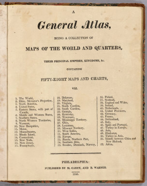
[Carey, Mathew, Warner, Benjamin]
Full Title
(Title Page to) A General Atlas, Being A Collection Of Maps Of The World And Quarters, Their Principal Empires, Kingdoms, &c. Containing Fifty Eight Maps And Charts. Philadelphia: Published By M. Carey, And B. Warner. 1816.
Publisher
M. Carey and B. Warner
Author
Sumner, Charles
Full Title
(Title Page to) Speech of Hon. Charles Sumner, Of Massachusetts, On The Cession Of Russian America to the United States. Washington: Printed at the Congressional Globe Office. (with Alaska map) Northwestern America Showing The Territory Ceded By Russia To The United States Compiled For The Department of State at the U.S. Coast Survey Office... Second Edition May 1867.
Publisher
Congressional Globe Office
Author
[Sonnenschein, W. Swan, Allen, Bevan, G.P.]
Full Title
(Title Page) Sonnenschein & Allen's Royal Relief Atlas of All Parts of the World. Consisting of 31 Maps, With Physical, Political, and Statistical Descriptions facing each Map. London: W. Swan Sonnenschein and Allen, Paternoster Square.
Publisher
Sonnenschein & Allen
Author
[Breese, Samuel, 1802-1873, Morse, Sidney E. (Sidney Edwards), 1794-1871]
Full Title
(Title Page, Contents to) Morse's North American atlas. Containing the following beautifully colored maps ... New York: Published by Harper & Brothers, 82 Cliff Street. Entered ... 1842, by Sidney E. Morse and Samuel Breese ... New York.
Publisher
Harper & Brothers
Author
Beers, J.B.
Full Title
(Title Page to) Atlas Of Staten Island, Richmond Co., New York. Compiled From Actual Surveys And Records By J.B. Beers & Co. 36 Vesey Street. New York. 1887. Entered ... 1887 by J.B. Beers & Co. ... Washington. Engraved And Printed By L.E. Neuman & Co. N.Y.
Publisher
Beers, J.B.
Author
Beers, F.W.
Full Title
(Title Page to) Atlas Of Long Island, New York. From Recent And Actual Surveys And Records Under the Superintendence of F.W. Beers. Published By Beers, Comstock & Cline, 36 Vesey Street, New York. 1873. Entered ... 1873 by Beers, Comstock & Cline ... Washington. Printed by Charles Hart, 36 Vesey St. N.Y. Engraved by L.E. Neuman, 36 Vesey St. N.Y.
Publisher
Beers, Comstock & Cline
Author
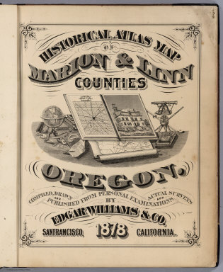
Williams, Edgar.
Full Title
(Title Page) Historical Atlas Map Of Marion & Linn Counties Oregon. Compiled, Drawn And Published From Personal Examinations And Actual Surveys By Edgar Williams & Co. San Francisco, California. 1878.
Publisher
Edgar Williams & Co.
Author
[Hitchcock, Charles H. (Charles Henry), 1836-1919, New Hampshire. Geological Survey]
Full Title
(Title Page to) Atlas accompanying the report on the geology of New Hampshire. C.H. Hitchcock, State Geologist. 1878. Julius Bien, New York.
Publisher
Julius Bien
Author
[Meacham, J.H. & Co., Allen, C.R.]
Full Title
(Table of Contents and Title Page) Illustrated Historical Atlas Of The Province Of Prince Edward Island. From Surveys made under the direction of C.R. Allen, C.E. Dedicated by Special Permission to His Excellency Sir John Douglas Sutherland Campbell K.T., K.M., K.G., Gov. General &c. By J.H. Meacham & Co. Publishers. 1880. Eng. by Worley & Bracher. 27 So. Sixth St. Phila. Pa. Printed by F. Bourquin. 31 So. Sixth St. Phila. Pa.
Publisher
J.H. Meacham & Co.
Author
[Bayer, Herbert, Container Corporation of America]
Full Title
(Title Page) World Geo-graphic Atlas, A Composite of Man's Environment. Geography, Geology, Demography, Astronomy, Climatology, Economics. Privately printed for Container Corporation of America, 1953, edited and designed by herbert bayer.
Publisher
Container Corporation of America
|