Who What Where WhenREMOVEWHEREShow More |
Author
Fremont, J.C.
Full Title
Las Mariposas Estate Mariposas County California. Containing 44,386 83/100 Acres Or 70 Square Miles. Lith of Sarony, Major & Knapp, 449 Broadway, N.Y. Max Strobel Engineer.
Publisher
Sarony, Major & Knapp
Author
[Frey, A.C., Nell, Louis]
Full Title
Topographical Railroad & County Map Of The States Of California And Nevada Compiled from the latest explorations and other official information by L. Nell, N.Y. Published by A.C. Frey & Co 204 Fulton St. New York. General Agents for California A. Roman & Co. 417 & 419 Montgomery St. San Francisco. Ferd. Mayer & Co. Lithographers, 96 Fulton St. N.Y. Entered ... 1868 by Frey & Nell ... New York. (inset) Map of the City of San Francisco, California. (inset) Map Of The Great National Pacific Railroads.
Publisher
A.C. Frey & Co.
Author
Hutawa, Julius
Full Title
(Covers to) Map Of Mexico & California. Compiled from the latest authorities. By Juls. Hutawa. Lithr. Second St. 45 St. Louis, Mo. 2nd Edition. 1863. (inset) Vicinity of Mexico.
Publisher
J. Hutawa
Author
Hutawa, Julius
Full Title
Map Of Mexico & California. Compiled from the latest authorities. By Juls. Hutawa. Lithr. Second St. 45 St. Louis, Mo. 2nd Edition. 1863. (inset) Vicinity of Mexico.
Publisher
J. Hutawa
Author
Goddard, George H. (George Henry), 1817-1906
Full Title
Britton & Rey's Map Of The State Of California. Compiled from the U.S. Land & Coast Surveys, the several Military, Scientific & Rail Road Explorations, the State & County Boundary Surveys made under the Order of the Surveyor General of California, & from Private Surveys. By George H. Goddard, C.E. Completed with Additions & Corrections up to the day of publication from the U.S. Land Office & other reliable sources. Lithy. Of Britton & Rey, Montgomery St. Cor. Commercial, S.F. Entered ... 1857 by Britton & Rey ... California. Engraved by H. Steinegger.
Publisher
Britton & Rey
Author
Goodwin, F.A.
Full Title
(Covers to) Map Of California And The Adjacent Country. Compiled by F. Goodwin From the best Authors and actual Observation. Entered ... 1855 by F. Goodwin ... New York. Lith. of Geo. E. Leefe, 223 Fulton St. N.Y. (with 8 page description) A Brief Description of California, From The Time of Its First Occupation by the United States and Subsequent Growth ... Accompanied by a Map of California and adjacent Country.
Publisher
Geo. E. Leefe
Author
Goodwin, F.A.
Full Title
Map Of California And The Adjacent Country. Compiled by F. Goodwin From the best Authors and actual Observation. Entered ... 1855 by F. Goodwin ... New York. Lith. of Geo. E. Leefe, 223 Fulton St. N.Y. (with 8 page description) A Brief Description of California, From The Time of Its First Occupation by the United States and Subsequent Growth ... Accompanied by a Map of California and adjacent Country.
Publisher
Geo. E. Leefe
Author
[Eddy, William M., Jones, William Carey]
Full Title
(Title Page to) Report of the Secretary of the Interior, Communicating A Copy of the report of William Carey Jones, special agent to examine the subject of land titles in California. ... January 30, 1851. Ordered to be printed. [Senate.] 31st Congress, 1st Session. Ex. Doc. No. 18. (With) Eddy's Official Map of San Francisco ... 1849.
Publisher
U.S.
Author
[Eddy, William M., Jones, William Carey]
Full Title
Official Map of San Francisco, Compiled from the Field Notes of the Official Re-Survey made by William M. Eddy. Surveyor of the Town of San Francisco, California. 1849. S.W. Higgins. Draftn. Copied by P.M. McGill C.E. & Draftn. Washington. C.B. Graham lith. Washington, D.C.
Publisher
U.S.
Author
King, Clarence
Full Title
(Covers to) Engineer Department U.S.A. Geological and Topographical Atlas Accompanying the Report of the Geological Exploration of the Fortieth Parallel Made by the Authority of the Honorable Secretary of War under the direction of Brig. and Brvt. Major General A.A. Humphreys, Chief of Engineers U.S.A. by Clarence King, U.S. Geologist in Charge, 1876. Julius Bien Lith.
Publisher
Julius Bien
Author
King, Clarence
Full Title
(Title Page to) Engineer Department U.S.A. Geological and Topographical Atlas Accompanying the Report of the Geological Exploration of the Fortieth Parallel Made by the Authority of the Honorable Secretary of War under the direction of Brig. and Brvt. Major General A.A. Humphreys, Chief of Engineers U.S.A. by Clarence King, U.S. Geologist in Charge, 1876. Julius Bien Lith.
Publisher
Julius Bien
Author
King, Clarence
Full Title
(Index Page to) Engineer Department U.S.A. Geological and Topographical Atlas Accompanying the Report of the Geological Exploration of the Fortieth Parallel Made by the Authority of the Honorable Secretary of War under the direction of Brig. and Brvt. Major General A.A. Humphreys, Chief of Engineers U.S.A. by Clarence King, U.S. Geologist in Charge, 1876. Julius Bien Lith.
Publisher
Julius Bien
Author
Mitchell, Samuel Augustus
Full Title
(Covers to) Map Of Mexico, Including Yucatan & Upper California, exhibiting The Chief Cities and Towns, The Principal Travelling Routes &c. Philadelphia: Published by S. Augustus Mitchell N.E. Corner Of Market And Seventh Sts. 1847. Entered ... 1846 by S. Augustus Mitchell ... Pennsylvania. (inset) The Late Battlefield.
Publisher
S.A. Mitchell
Author
Thompson & West
Full Title
Map of Fairfield and Suisun, Solano County, Cal. (Published by Thompson & West, San Francisco, Cala, 1878)
Publisher
Thompson & West
Author
Thompson & West
Full Title
"Cherry Glen Farm," residence of J.M. Bassford, Jr., wife and sister, Vacaville, Solano Co., Cal. Residence of W. Cantelow, Pleasant Valley, Solano County, California. (Thompson & West, San Francisco, Cala., 1878)
Publisher
Thompson & West
Author
Thompson & West
Full Title
Map of Dixon, Solano Co., Cal. (Published by Thompson & West, San Francisco, Cala, 1878)
Publisher
Thompson & West
Author
Thompson & West
Full Title
Residence of A.C. Hawkins, 580 acres, Elmira Tp. ... Residence of John S. Mayes, Dixon ... (both) Solano County, California. (Thompson & West, San Francisco, Cala., 1878)
Publisher
Thompson & West
Author
Clason Map Company
Full Title
(Covers to) Nevada And The Southeastern Portion Of California. Third Edition 1907. The Clason Map Company. Publishers Of Advertising And Reference Maps Denver, Colorado. Copyrighted 1906 And 1907 By Geo. S. Clason, Denver, Colorado.
Publisher
Clason Map Company
Author
Clason Map Company
Full Title
(Title Page to) Nevada And The Southeastern Portion Of California. Third Edition 1907. The Clason Map Company. Publishers Of Advertising And Reference Maps Denver, Colorado. Copyrighted 1906 And 1907 By Geo. S. Clason, Denver, Colorado.
Publisher
Clason Map Company
Author
Clason Map Company
Full Title
Nevada And The Southeastern Portion Of California. Third Edition 1907. The Clason Map Company. Publishers Of Advertising And Reference Maps Denver, Colorado. Copyrighted 1906 And 1907 By Geo. S. Clason, Denver, Colorado.
Publisher
Clason Map Company
Author
Denny, Edward & Co.
Full Title
(Covers to) Denny's Pocket Map Of Fresno County California. Compiled From Latest Official And Private Data. Edward Denny & Co. Map Publishers 1132 Shotwell St., San Francisco. Copyright 1911 By Edward Denny & Co.
Publisher
Edward Denny & Co.
Author
Denny, Edward & Co.
Full Title
Denny's Pocket Map Of Fresno County California. Compiled From Latest Official And Private Data. Edward Denny & Co. Map Publishers 1132 Shotwell St., San Francisco. Copyright 1911 By Edward Denny & Co.
Publisher
Edward Denny & Co.
Author
Schonberg & Co.
Full Title
California and the Western Territories.
Publisher
Schonberg & Co.
Author
Asher & Adams
Full Title
Asher & Adams' California & Nevada. South portion. Entered according to Act of Congress in the year 1874 by Asher & Adams ... at Washington. (New York, 1874)
Publisher
Asher and Adams
Author
Asher & Adams
Full Title
Asher & Adams' California & Nevada. North portion. Entered according to Act of Congress in the year 1874 by Asher & Adams ... at Washington. (New York, 1874)
Publisher
Asher and Adams
Author
Schonberg & Co.
Full Title
Schonberg's Map of California, Oregon & Nevada with Part of Idaho, Utah & Arizona. Entered ... 1866 .. New York.
Publisher
Schonberg & Co.
Author
Asher & Adams
Full Title
(Composite of) Asher & Adams' California & Nevada. Entered according to Act of Congress in the year 1874 by Asher & Adams ... at Washington. (New York, 1874)
Publisher
Asher and Adams
Author
Tanner, Henry S.
Full Title
(Covers to) Map of California New Mexico Texas &c. Published by H.S. Tanner No. 156 Fulton St. New York 1849.
Publisher
H.S. Tanner
Author
Shell Oil Company
Full Title
Shell Map of California (cover title). Shell Highway Map of California (northern portion). 6-DD-1956-4. (inset) Enlarged Map of the San Francisco District.
Publisher
Shell Oil Company
Author
Shell Oil Company
Full Title
Shell Highway Map of California (southern portion). (inset) Enlarged Map of the Los Angeles District. (Verso to) Shell Highway Map of California (northern portion).
Publisher
Shell Oil Company
Author
Shell Oil Company
Full Title
Reno. Las Vegas. Lake Tahoe. Yosemite National Park. (Verso to) Shell Highway Map of Nevada.
Publisher
Shell Oil Company
Author
Vancouver, George, 1757-1798
Full Title
Cote nord-ouest de l'Amerique. Reconnue par le Cape. Vancouver. 1e. partie, depuis 3000' de latitude septle. et 244032' de longitude jusqu'a 38030' de late. et 237013' de longe. (with) Port St. Diego. (with) Entree de Port St. Francisco. Voyage de Vancouver. No. 4. (Paris: Depot-general de la Marine, 1828)
Publisher
Depot de la Marine
Author
Vancouver, George, 1757-1798
Full Title
Cote nord-ouest de l'Amerique. Reconnue par le Cape. Vancouver. 2e. partie, depuis 38015' de latitude septle. et 237027' de longitude jusqu'a 45046' de late. et 236015' de longe. (with) Baie de la Trinidad. Voyage de Vancouver. No. 5. (Paris: Depot-general de la Marine, 1828)
Publisher
Depot de la Marine
Author
[France. Depot-general de la Marine, Malaspina, Alessandro, 1754-1809, Spain. Marina]
Full Title
Carte reduite des cotes et du Golfe du Californie, depuis le Cap Corrientes jusqu'au Port St. Diego. D'apres des observations faites a bord des corvettes la Descubierta et l'Atrevida et celles de plusieurs officiers de la Marine Espagnole, Madrid 1825. (with) Plan du Port de Guaimas. (with) Plan de la Baie de La Paz. (with) Plan du Port de Pichilingue. Publiee par ordre du Roi. Sous le Ministere de Son Excellence M. le Comte Chabrol de Crousol, Pair de France, Secretaire d'Etat au Departement de la Marine et des Colonies. Au Depot-general de la Marine, 1826. Grave par Vicq. Ecrit par Besancon.
Publisher
Depot de la Marine
Author
Weber, C.F.
Full Title
(Covers to) Weber's Township And County Map Of California And Nevada Compiled From The Latest Official Data. Published By C.F. Weber & Co. San Francisco And Los Angeles California. Copyright, 1910, By C.F. Weber & Co. Photo-Lith. Britton & Rey.
Publisher
C.F. Weber & Co.
Author
Weber, C.F.
Full Title
(Title Page to) Weber's Township And County Map Of California And Nevada Compiled From The Latest Official Data. Published By C.F. Weber & Co. San Francisco And Los Angeles California. Copyright, 1910, By C.F. Weber & Co. Photo-Lith. Britton & Rey.
Publisher
C.F. Weber & Co.
Author
Weber, C.F.
Full Title
Weber's Township And County Map Of California And Nevada Compiled From The Latest Official Data. Published By C.F. Weber & Co. San Francisco And Los Angeles California. Copyright, 1910, By C.F. Weber & Co. Photo-Lith. Britton & Rey.
Publisher
C.F. Weber & Co.
Author
Denny, Edward & Co.
Full Title
(Covers to) Denny's Pocket Map Of Ventura County, California. Compiled From Latest Official And Private Data By Edward Denny & Co. Map Publishers 1132 Shotwell St., San Francisco. Copyright 1913 By Edward Denny & Co.
Publisher
Edward Denny & Co.
Author
Denny, Edward & Co.
Full Title
Denny's Pocket Map Of Ventura County, California. Compiled From Latest Official And Private Data By Edward Denny & Co. Map Publishers 1132 Shotwell St., San Francisco. Copyright 1913 By Edward Denny & Co.
Publisher
Edward Denny & Co.
Author
Willson & Co.
Full Title
(Covers to) Willson & Co.'s Indexed Sectional Map Of Southern California. Compiled And Published By Willson & Co., Map Publishers, 213 Powell St. San Francisco, Cal. Copyrighted 1895. Galloway Litho.Co. S.F.
Publisher
Willson & Co.
Author
Willson & Co.
Full Title
Willson & Co.'s Indexed Sectional Map Of Southern California. Compiled And Published By Willson & Co., Map Publishers, 213 Powell St. San Francisco, Cal. Copyrighted 1895. Galloway Litho.Co. S.F.
Publisher
Willson & Co.
Author
[Bancroft, H.H., Knight, W.H.]
Full Title
(Covers to) Bancroft's Map Of Central California. Compiled by Wm. Henry Knight. Published By H.H. Bancroft & Co. 609 Montgomery St. San Francisco 1869. Entered ... 1868, by H.H. Bancroft & Co. ... California. J. & R. McLellan N.Y. The Map Of Central California Is Published In Pocket Form, Price 50 Cents.
Publisher
H.H. Bancroft & Co.
Author
[Bancroft, H.H., Knight, W.H.]
Full Title
Bancroft's Map Of Central California. Compiled by Wm. Henry Knight. Published By H.H. Bancroft & Co. 609 Montgomery St. San Francisco 1869. Entered ... 1868, by H.H. Bancroft & Co. ... California. J. & R. McLellan N.Y. The Map Of Central California Is Published In Pocket Form, Price 50 Cents.
Publisher
H.H. Bancroft & Co.
Author
Clason Map Company
Full Title
(Covers to) Midget Map Of The Best Roads Of California And Nevada. The Clason Map Co. Chicago-Denver. Copyrighted The C.M. Co. All Rights Reserved.
Publisher
Clason Map Company
Author
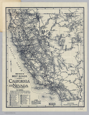
Clason Map Company
Full Title
Midget Map Of The Best Roads Of California And Nevada. The Clason Map Co. Chicago-Denver. Copyrighted The C.M. Co. All Rights Reserved.
Publisher
Clason Map Company
Author
Pacific Southwest Trust & Savings Bank
Full Title
(Covers to) Midget Map of Santa Ana California. Issued by Santa Ana Branch Pacific-Southwest Trust & Savings Bank, 102 E. Fourth St. Santa Ana, Calif. Copyrighted by Franklin P. Borgnis, L.A. (on verso) Motor And Relief Map Of Southern California. Issued by Santa Ana Branch Pacific-Southwest Trust & Savings Bank Identical In Ownership With The First National Bank of Los Angeles and the First Securities Company. This Map copyrighted, 1923, by Pacific-Southwest Trust & Savings Bank.
Publisher
Pacific Southwest Trust & Savings Bank
Author
Pacific Southwest Trust & Savings Bank
Full Title
Midget Map of Santa Ana California. Issued by Santa Ana Branch Pacific-Southwest Trust & Savings Bank, 102 E. Fourth St. Santa Ana, Calif. Copyrighted by Franklin P. Borgnis, L.A. (on verso) Motor And Relief Map Of Southern California. Issued by Santa Ana Branch Pacific-Southwest Trust & Savings Bank Identical In Ownership With The First National Bank of Los Angeles and the First Securities Company. This Map copyrighted, 1923, by Pacific-Southwest Trust & Savings Bank.
Publisher
Pacific Southwest Trust & Savings Bank
Author
Pacific Southwest Trust & Savings Bank
Full Title
Motor And Relief Map Of Southern California. Issued by Santa Ana Branch Pacific-Southwest Trust & Savings Bank Identical In Ownership With The First National Bank of Los Angeles and the First Securities Company. This Map copyrighted, 1923, by Pacific-Southwest Trust & Savings Bank. (on verso) Midget Map of Santa Ana California. Issued by Santa Ana Branch Pacific-Southwest Trust & Savings Bank, 102 E. Fourth St. Santa Ana, Calif. Copyrighted by Franklin P. Borgnis, L.A.
Publisher
Pacific Southwest Trust & Savings Bank
Author
Pacific Southwest Trust & Savings Bank
Full Title
(Covers to) Midget Map of San Luis Obispo California. Issued by San Luis Obispo Branch Pacific-Southwest Trust & Savings Bank, Chorro and Higuera Streets, San Luis Obispo, Calif. Copyrighted by Franklin P. Borgnis, L.A. (on verso) Motor And Relief Map Of The Pacific-Southwest. Issued by San Luis Obispo Branch Pacific-Southwest Trust & Savings Bank Affiliated With The First National Bank of Los Angeles and the First Securities Company ... Copyright 1923 by The First National Bank of Los Angeles all rights reserved.
Publisher
Pacific Southwest Trust & Savings Bank
Author
Pacific Southwest Trust & Savings Bank
Full Title
Midget Map of San Luis Obispo California. Issued by San Luis Obispo Branch Pacific-Southwest Trust & Savings Bank, Chorro and Higuera Streets, San Luis Obispo, Calif. Copyrighted by Franklin P. Borgnis, L.A. (on verso) Motor And Relief Map Of The Pacific-Southwest. Issued by San Luis Obispo Branch Pacific-Southwest Trust & Savings Bank Affiliated With The First National Bank of Los Angeles and the First Securities Company ... Copyright 1923 by The First National Bank of Los Angeles all rights reserved.
Publisher
Pacific Southwest Trust & Savings Bank
|