Who What Where WhenREMOVEWHEREShow More |
Author
Thompson & West
Full Title
Easterday & Co. ... Hensley House, W.G. Campbell, propr., San Jose, Cal. Res. of Wm. Winslow, San Jose, Cal. John Paine's Livery Stable, Gilroy, Cal. Watkins & Scott, manufacturers ... San Jose, Cal. (Published by Thompson & West, San Francisco, 1876)
Publisher
Thompson & West
Author
[Moore, E. S., Thompson & West]
Full Title
Ayrshire Farm - 1242 acres. Res. of Peter Coutts, Esq., Mayfield, Santa Clara Co., Cal. Moore, del. (Published by Thompson & West, San Francisco, 1876)
Publisher
Thompson & West
Author
Thompson & West
Full Title
"Lone Tree Ranch" res. of Hon. S.I. Jamison, Santa Clara, Cal. (Published by Thompson & West, San Francisco, 1876)
Publisher
Thompson & West
Author
Thompson & West
Full Title
Res. of A.B. Hunter, Santa Clara, Cal. Res. of Lambert Dornberger, Mayfield, Santa Clara Co., Cal. (Published by Thompson & West, San Francisco, 1876)
Publisher
Thompson & West
Author
Thompson & West
Full Title
Strawberry Ranch ... Chas E. Wade, proprietor, Alviso ... Res. of J.R. Weller, Milpitas ... (both) Santa Clara Co., Cal. (Published by Thompson & West, San Francisco, 1876)
Publisher
Thompson & West
Author
Thompson & West
Full Title
Pacific Congress Springs, 12 miles south-west from San Jose, Cal. L.A. Sage, proprietor. (Drawn by H.A. Published by Thompson & West, San Francisco, 1876)
Publisher
Thompson & West
Author
Thompson & West
Full Title
Res. of Charles C. Smith. Store & residence of F.J. Smith ... Res. of Adam Herman ... (both) Evergreen, Santa Clara Co., Cal. (Published by Thompson & West, San Francisco, 1876)
Publisher
Thompson & West
Author
Thompson & West
Full Title
Residence of M. Tantau, Santa Clara, Cal. (Published by Thompson & West, San Francisco, 1876)
Publisher
Thompson & West
Author
Thompson & West
Full Title
Res. of Mrs. Sarah Wallis, Mayfield, Santa Clara Co., Cal. (Published by Thompson & West, San Francisco, 1876)
Publisher
Thompson & West
Author
Thompson & West
Full Title
Res. of Henry Van Syckle, San Jose, Cal. (Published by Thompson & West, San Francisco, 1876)
Publisher
Thompson & West
Author
Thompson & West
Full Title
Residence of William Quinn, San Jose, California. (Published by Thompson & West, San Francisco, 1876)
Publisher
Thompson & West
Author
Thompson & West
Full Title
St. Joseph's Church, San Jose. Hoffmann & Clinch, architects. (Published by Thompson & West, San Francisco, 1876)
Publisher
Thompson & West
Author
Thompson & West
Full Title
Residence of John Messersmith, Santa Clara, California. (Published by Thompson & West, San Francisco, 1876)
Publisher
Thompson & West
Author
Thompson & West
Full Title
Residence of Silvester Graves, Santa Clara, Cal. (Published by Thompson & West, San Francisco, 1876)
Publisher
Thompson & West
Author
Thompson & West
Full Title
Evergreen Avenue Farm, res. of P. Hillebrant ... Santa Clara, Cal. (Published by Thompson & West, San Francisco, 1876)
Publisher
Thompson & West
Author
[Bielawski, C., Hoffman, Hoffmann, J.D., Poett, A.]
Full Title
(Covers to) Topographical And Railroad Map of the Central Part of the State of California, and Part of the State Of Nevada. 1865. Compiled from Railroad Surveys, U.S. Public Land Surveys, U.S. Coast Surveys, California State Geological Survey (Prof. J.D. Whitney), and from reliable private Surveys, and Published by C. Bielawski, J.D. Hoffmann & A. Poett, Civil Engineers & Survrs. Britton & Co. Lith: San Francisco. Entered ... 1865 by J.D. Hoffmann & A. Poett ... California.
Publisher
Britton & Co. Lith.
Author
[Bielawski, C., Hoffman, Hoffmann, J.D., Poett, A.]
Full Title
Topographical And Railroad Map of the Central Part of the State of California, and Part of the State Of Nevada. 1865. Compiled from Railroad Surveys, U.S. Public Land Surveys, U.S. Coast Surveys, California State Geological Survey (Prof. J.D. Whitney), and from reliable private Surveys, and Published by C. Bielawski, J.D. Hoffmann & A. Poett, Civil Engineers & Survrs. Britton & Co. Lith: San Francisco. Entered ... 1865 by J.D. Hoffmann & A. Poett ... California.
Publisher
Britton & Co. Lith.
Author
Blum, George W.
Full Title
(Covers to) The Cyclers' Guide and Road Book of California Containing Map of California in relief with principal Roads, Seven Sectional Maps showing all available Roads for Cyclers from Chico to San Diego, and a Map of Golden Gate Park. 1896. Price, One Dollar. Compiled and Published by Geo. W. Blum, 330 Pine St., S.F. Edward Denny & Co., Agents. (on verso) Copyrighted 1895 By Geo. W. Blum, San Francisco, Cal.
Publisher
Geo. W. Blum
Author
Blum, George W.
Full Title
(Title Page to) The Cyclers' Guide and Road Book of California Containing Map of California in relief with principal Roads, Seven Sectional Maps showing all available Roads for Cyclers from Chico to San Diego, and a Map of Golden Gate Park. 1896. Price, One Dollar. Compiled and Published by Geo. W. Blum, 330 Pine St., S.F. Edward Denny & Co., Agents. (on verso) Copyrighted 1895 By Geo. W. Blum, San Francisco, Cal.
Publisher
Geo. W. Blum
Author
Blum, George W.
Full Title
Map of the Golden Gate Park, the Avenue and Buena Vista Park. 1895.
Publisher
Geo. W. Blum
Author
Blum, George W.
Full Title
Untitled map of Sonoma, Marin, Lake, and Napa Counties.
Publisher
Geo. W. Blum
Author
Blum, George W.
Full Title
(Untitled map of the South Bay including San Mateo, Santa Cruz, Santa Clara, Alameda, and Contra Costa Counties.)
Publisher
Geo. W. Blum
Author
Blum, George W.
Full Title
(Untitled map of the area around Sacramento and Marysville including Colusa, Yolo, Napa, Butte, Yuba, Sutter, Solano, and Sacramento Counties.)
Publisher
Geo. W. Blum
Author
Blum, George W.
Full Title
(Untitled map of the Central Coast area including San Benito, Fresno, Monterey, San Luis Obispo, Kings, Kern, and Santa Barbara Counties.)
Publisher
Geo. W. Blum
Author
Higley, Horace A.
Full Title
Official Map Of The County Of Alameda California Surveyed and compiled by Order of the Board of Supervisors. Horace A. Higley, County Surveyor. April - 1857. Lithy. of Britton & Rey, S.F.
Publisher
Britton & Rey
Author
Blum, George W.
Full Title
(Untitled map of the Central Valley area including Sacramento, Amador, Calaveras, San Joaquin, Tuolumne, Stanislaus, Merced, and Mariposa Counties.)
Publisher
Geo. W. Blum
Author
Blum, George W.
Full Title
(Untitled map of Southern California including Ventura, Los Angeles, San Bernardino, Orange, and San Diego Counties.)
Publisher
Geo. W. Blum
Author
Blum, George W.
Full Title
Map of California Roads for Cyclers. This Map Engraved by the California Photo-Eng. Co. Wasp B'ld'g., 513 Market St., S.F. Designed & Drawn by Geo. W. Blum. Edward Denny & Co. 207 Montgomery St. Sole Agents. Published and Copyrighted by Geo. W. Blum, San Francisco, Cal. (with) Inset map of the Los Angeles area.
Publisher
Geo. W. Blum
Author
[Craven, A., Hoffman, Hoffmann, C.F., Leicht, F., Geological Survey of California]
Full Title
State Geological Survey Of California, J.D. Whitney, State Geologist. Map Of California And Nevada. Drawn By F.v. Leicht And A. Craven ... J. Bien, Lith. N.Y. 2nd edition Revised by Hoffmann and Craven and issued by authority of the Regents of the University of California given May 12th 1874.
Publisher
Julius Bien
Author
United States. Congress
Full Title
Map Of The San Joaquin, Sacramento And Tulare Valleys, State Of California, prepared under the direction of the Board Of Commissioners On Irrigation appointed under the Act of Congress approved March 3rd 1873, showing the country that may be irrigated and a Provisional System Of Irrigation Compiled from the Maps of the Geological Survey Of California and from Special Surveys and Examinations. 1873. Published by authority of the Hon. Secretary of War in the Office of the Chief of Engineers U.S. Army.
Publisher
U.S.
Author
Colton, G.W.
Full Title
California. (with) City of San Francisco. Published By J.H. Colton & Co. No. 172 William St. New York. Entered ... 1855 by J.H. Colton ... New York. No. 52.
Publisher
J.H. Colton
Author
Duflot de Mofras, Eugene
Full Title
(Covers to) Exploration Du Territoire De L'Oregon, Des Californies Et De La Mer Vermeille, Executee Pendant Les Annees 1840, 1841 Et 1842, Par M. Duflot De Mofras, Attache A La Legation De France A Mexico. Ouvrage Publie Par Ordre Du Roi, Sous Les Auspices De M. Le Marechal Soult, Duc De Dalmatie, President du Conseil, Et De M. Le Ministre Des Affaires Etrangeres. Tome Premier. Paris, Arthus Bertrand, Editeur, Libraire De La Societe De Geographie, Rue Hautefeuille, No. 23. 1844. Paris. - Typographie de Firmin Didot Freres, rue Jacob, 56 ... Tome Second ... Atlas (with map) Carte De La Cote De L'Amerique Sur L'Ocean Pacifique Septentrional comprenant Le Territoire De L'Oregon, Les Californies, La Mer Vermeille ...
Publisher
Arthus Bertrand
Author
Duflot de Mofras, Eugene
Full Title
(Half Title Page to) Exploration Du Territoire De L'Oregon, Des Californies Et De La Mer Vermeille, Executee Pendant Les Annees 1840, 1841 Et 1842, Par M. Duflot De Mofras, Attache A La Legation De France A Mexico. Ouvrage Publie Par Ordre Du Roi, Sous Les Auspices De M. Le Marechal Soult, Duc De Dalmatie, President du Conseil, Et De M. Le Ministre Des Affaires Etrangeres. Tome Premier. Paris, Arthus Bertrand, Editeur, Libraire De La Societe De Geographie, Rue Hautefeuille, No. 23. 1844. Paris. - Typographie de Firmin Didot Freres, rue Jacob, 56 ... Tome Second ... Atlas (with map) Carte De La Cote De L'Amerique Sur L'Ocean Pacifique Septentrional comprenant Le Territoire De L'Oregon, Les Californies, La Mer Vermeille ...
Publisher
Arthus Bertrand
Author
Duflot de Mofras, Eugene
Full Title
(Title Page to) Exploration Du Territoire De L'Oregon, Des Californies Et De La Mer Vermeille, Executee Pendant Les Annees 1840, 1841 Et 1842, Par M. Duflot De Mofras, Attache A La Legation De France A Mexico. Ouvrage Publie Par Ordre Du Roi, Sous Les Auspices De M. Le Marechal Soult, Duc De Dalmatie, President du Conseil, Et De M. Le Ministre Des Affaires Etrangeres. Tome Premier. Paris, Arthus Bertrand, Editeur, Libraire De La Societe De Geographie, Rue Hautefeuille, No. 23. 1844. Paris. - Typographie de Firmin Didot Freres, rue Jacob, 56 ... Tome Second ... Atlas (with map) Carte De La Cote De L'Amerique Sur L'Ocean Pacifique Septentrional comprenant Le Territoire De L'Oregon, Les Californies, La Mer Vermeille ...
Publisher
Arthus Bertrand
Author
Duflot de Mofras, Eugene
Full Title
(Index to) Exploration Du Territoire De L'Oregon, Des Californies Et De La Mer Vermeille, Executee Pendant Les Annees 1840, 1841 Et 1842, Par M. Duflot De Mofras, Attache A La Legation De France A Mexico. Ouvrage Publie Par Ordre Du Roi, Sous Les Auspices De M. Le Marechal Soult, Duc De Dalmatie, President du Conseil, Et De M. Le Ministre Des Affaires Etrangeres. Tome Premier. Paris, Arthus Bertrand, Editeur, Libraire De La Societe De Geographie, Rue Hautefeuille, No. 23. 1844. Paris. - Typographie de Firmin Didot Freres, rue Jacob, 56 ... Tome Second ... Atlas (with map) Carte De La Cote De L'Amerique Sur L'Ocean Pacifique Septentrional comprenant Le Territoire De L'Oregon, Les Californies, La Mer Vermeille ...
Publisher
Arthus Bertrand
Author
Duflot de Mofras, Eugene
Full Title
Carte De La Cote De L'Amerique Sur L'Ocean Pacifique Septentrional Le Territoire De L'Oregon, Les Californies, La Mer Vermeille, Partie des Territoires de la Compagnie de la Baie d'Hudson, Et De L'Amerique Russe. Dressee par Mr. Duflot de Mofras, Attache a la Legation de France a Mexico; Pour servir a l'intelligence de son Voyage d'exploration Publie Par Ordre Du Roi, sous les Auspices De Mr. Le Marechal Duc De Dalmatie, Mr. Le Ministre Des Affaires Etrangeres. Paris, 1844. Le plan grave par Jacobs. L'ecriture gravee par Hacq. Publie par Arthus Bertrand.
Publisher
Arthus Bertrand
Author
Duflot de Mofras, Eugene
Full Title
Plan De L'Embouchure Du Rio Colorado dans la Mer Vermeille. No. 10. (with) Plan Du Port De S. Diego situe sur la cote septentrionale De La Californie. No. 11. Publie Par Arthus Bertrand. Voyage de Mr. Duflot de Mofras.
Publisher
Arthus Bertrand
Author
Duflot de Mofras, Eugene
Full Title
Mouillage De San Pedro. No. 12. (with) Mouillage De La Mission De Sta. Barbara. No. 13. Publie Par Arthus Bertrand. Voyage de Mr. Duflot de Mofras.
Publisher
Arthus Bertrand
Author
Duflot de Mofras, Eugene
Full Title
Plan du Port Et De La Baie De Monte-Rey situes sur la Cote Septle. de la Californie. No. 14. (with) Baie De La Trinidad. No. 15. Publie Par Arthus Bertrand. Voyage de Mr. Duflot de Mofras.
Publisher
Arthus Bertrand
Author
Duflot de Mofras, Eugene
Full Title
Port De San Francisco Dans La Haute Californie. No. 16. (with) Entree Du Port De San Francisco et des mouillages del Sausalito et de la Yerba Buena. Publie Par Arthus Bertrand. Grave par S. Jacobs. Voyage de Mr. Duflot de Mofras.
Publisher
Arthus Bertrand
Author
Duflot de Mofras, Eugene
Full Title
Carte Detaillee Du Mouillage Du Fort Ross et du Port De La Bodega ou Romanzoff dans la Nouvelle Californie, occupes par les Russes. No. 17. Publie Par Arthus Bertrand. Voyage de Mr. Duflot de Mofras.
Publisher
Arthus Bertrand
Author
Duflot de Mofras, Eugene
Full Title
Vue De La Mission De Saint Louis Roi De France dans la Nouvelle Californie. No. 23 de l'Atlas. Publie Par Arthus Bertrand. Imp. par Lemercier. Lith par Muller. Voyage de Mr. Duflot de Mofras.
Publisher
Arthus Bertrand
Author
Duflot de Mofras, Eugene
Full Title
Plan Geometrique De La Mission De St. Louis Roi De France. Dans la Nouvelle Californie. No. 24 de l'Atlas. Paris Arthus Bertrand, Editeur. Grave sur pierre par Ch. Avril. Lith. de Bineteau. Voyage de Mr. Duflot de Mofras.
Publisher
Arthus Bertrand
Author
Duflot de Mofras, Eugene
Full Title
Tete De Chef Indien De La Cote Nord Ouest De L'Amerique. Armes et ustensiles des Indiens de la Nouvelle Californie. No. 25 de l'Atlas. Publie par Arthus Bertrand. Imp. par Lemercier. Lith. par Muller. Voyage de Mr. Duflot de Mofras.
Publisher
Arthus Bertrand
Author
Emory, William H.
Full Title
(Title Page to) Notes of a Military Reconnoissance, From Fort Leavenworth, In Missouri, To San Diego, In California, Including Part of the Arkansas, Del Norte, and Gila Rivers. By W.H. Emory, Brevet Major, Corps Topographical Engineers. Made in 1846-7, with the Advanced Guard of the "Army of the West." Washington: Wendell and van Benthuysen, Printers. 1848. [Senate] 30th Congress, 1st Session. Executive, No. 7.
Publisher
Wendell and Van Benthuysen
Author
Emory, William H.
Full Title
Military Reconnaissance Of The Arkansas Rio Del Norte And Rio Gila By W.H. Emory, Lieut. Top. Engrs. Assisted ... by J.W. Abert and W.G. Peck, and ... by W.H. Warner and Mr. Norman Bestor, Made in 1846-7, with the advance guard of the "Army of the West". Under Command Of Brig. Gen. Stephn. W. Kearny. Constructed under the orders of Col. J.J. Abert ... 1847. Drawn by Joseph Welch. Engraved on stone by E. Weber & Co. Baltimore.
Publisher
Wendell and Van Benthuysen
Author
Fremont, J.C.
Full Title
(Title Page to) Report of The Exploring Expedition to The Rocky Mountains in the Year 1842, and to Oregon and North California in the Years 1843-'44.
Publisher
Blair and Rives
Author
Fremont, J.C.
Full Title
Map Of An Exploring Expedition To The Rocky Mountains in the Year 1842, Oregon & North California In The Years 1843-44. By Brevet Capt. J. C. Fremont Of The Corps Of Topographical Engineers Under the orders of Col. J.J. Abert, Chief Of The Topographical Bureau. Lith. by E. Weber & Co. Baltimore, Md.
Publisher
Blair and Rives
Author
Fremont, J.C.
Full Title
(Title Page to) Geographical Memoir upon Upper California In Illustration of His Map of Oregon and California, by John Charles Fremont: Addressed to the Senate of the United States. Washington: Wendell and Van Benthuysen, Printers. 1848. [Senate.] 30th Congress, 1st Session. Miscellaneous. No. 148.
Publisher
Wendell and Van Benthuysen
Author
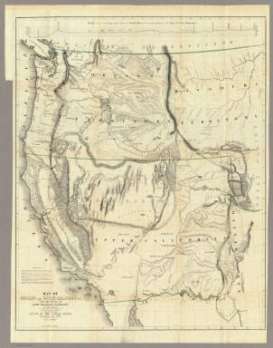
Fremont, J.C.
Full Title
Map Of Oregon And Upper California From the Surveys of John Charles Fremont And other Authorities. Drawn By Charles Preuss Under the Order of the Senate Of The United States, Washington City 1848. Lithy. by E. Weber & Co. Balto. (inset) Profile of the travelling route from the South Pass of the Rocky Mountains to the Bay of San Francisco.
Publisher
Wendell and Van Benthuysen
|