Who What Where WhenREMOVEWHATShow MoreWHERE
|
Author
Kirkham, H.B.
Full Title
(Covers to) Travellers' Guide of the Hudson River. Published by H.B. Kirkham, for the Proprietor, and for sale on all the Steamboats, and at the principal Hotels in the United States. Price One Shilling.
Publisher
H.B. Kirkham
Author
Kirkham, H.B.
Full Title
Travellers' Guide of the Hudson River. Published by H.B. Kirkham, for the Proprietor, and for sale on all the Steamboats, and at the principal Hotels in the United States. Price One Shilling.
Publisher
H.B. Kirkham
Author
[Colton, G.W. & C.B., Ely, W.W.]
Full Title
(Covers to) Map Of The New York Wilderness And The Adirondacks. By W.W. Ely, M.D. Engraved, Printed and Published By G.W. & C.B. Colton & Co. No. 172 William St. New York. 1879. Entered ... 1873 by G.W. & C.B. Colton & Co. ... Washington. (untitled inset of the New York State and New England states).
Publisher
G.W. & C.B. Colton
Author
[Colton, G.W. & C.B., Ely, W.W.]
Full Title
Map Of The New York Wilderness And The Adirondacks. By W.W. Ely, M.D. Engraved, Printed and Published By G.W. & C.B. Colton & Co. No. 172 William St. New York. 1879. Entered ... 1873 by G.W. & C.B. Colton & Co. ... Washington. (untitled inset of the New York State and New England states).
Publisher
G.W. & C.B. Colton
Author
Magnus, Charles
Full Title
(Covers to) City Of Brooklyn with Part of New York. Publh. & sold by Chs. Magnus No. 22 North William St. Vicinity of New York. Publ. & Sold by Magnus & Co. 77 Chatham St. Map of the City of Williamsburgh with Part of Greenpoint. Lith. of Chs. Magnus, N.Y. (Three small maps on one sheet).
Publisher
Charles Magnus
Author
Magnus, Charles
Full Title
City Of Brooklyn with Part of New York. Publh. & sold by Chs. Magnus No. 22 North William St. (with map) Vicinity of New York. Publ. & Sold by Magnus & Co. 77 Chatham St. (with map) Map of the City of Williamsburgh with Part of Greenpoint. Lith. of Chs. Magnus, N.Y. (Three small maps on one sheet).
Publisher
Charles Magnus
Author
[Bien, Joseph Rudolf, Vermeule, C. C. (Cornelius Clarkson), 1858-1950]
Full Title
Index map showing the area covered by this atlas, and boundaries and numbers of the various maps. Copyrighted by Julius Bien & Co., 1890. (1891)
Publisher
Julius Bien
Author
[Bien, Joseph Rudolf, Vermeule, C. C. (Cornelius Clarkson), 1858-1950]
Full Title
City and county of New York. Copyrighted by Julius Bien & Co., 1890. (1891)
Publisher
Julius Bien
Author
[Bien, Joseph Rudolf, Vermeule, C. C. (Cornelius Clarkson), 1858-1950]
Full Title
Brooklyn, New York Bay, Jersey City, Hoboken, Bayonne and Newark Bay. Copyrighted by Julius Bien & Co., 1890. (1891)
Publisher
Julius Bien
Author
[Bien, Joseph Rudolf, Vermeule, C. C. (Cornelius Clarkson), 1858-1950]
Full Title
The Narrows to Jamaica Bay-Coney Island, north to Brooklyn. Copyrighted by Julius Bien & Co., 1890. (1891)
Publisher
Julius Bien
Author
[Bien, Joseph Rudolf, Vermeule, C. C. (Cornelius Clarkson), 1858-1950]
Full Title
Richmond County, Staten Island. Copyrighted by Julius Bien & Co., 1890. (1891)
Publisher
Julius Bien
Author
[Bien, Joseph Rudolf, Vermeule, C. C. (Cornelius Clarkson), 1858-1950]
Full Title
Long Island Sound, Westchester north to Mt. Vernon, Queens south to Jamaica. Copyrighted by Julius Bien & Co., 1890. (1891)
Publisher
Julius Bien
Author
[Bien, Joseph Rudolf, Vermeule, C. C. (Cornelius Clarkson), 1858-1950]
Full Title
Westchester County, Yonkers to Dobbs Ferry, east to state line. Copyrighted by Julius Bien & Co., 1890. (1891)
Publisher
Julius Bien
Author
[Bien, Joseph Rudolf, Vermeule, C. C. (Cornelius Clarkson), 1858-1950]
Full Title
Westchester County, Irvington, Tarrytown to Sing Sing, east to state line. Copyrighted by Julius Bien & Co., 1890. (1891)
Publisher
Julius Bien
Author
[Bien, Joseph Rudolf, Vermeule, C. C. (Cornelius Clarkson), 1858-1950]
Full Title
(Contents to) Atlas of the Metropolitan District and adjacent country comprising the counties of New York, Kings, Richmond, Westchester and part of Queens in the state of New York, the County of Hudson and parts of the counties of Bergen, Passaic, Essex and Union in the state of New Jersey ... From original surveys by J.R. Bien and C.C. Vermeule, the U.S. Coast and Geodetic Survey and the Geological Survey of New Jersey. Published by Julius Bien & Co. New York. 1891.
Publisher
Julius Bien
Author
Mitchell, Samuel Augustus Jr.
Full Title
County map of the state of New York. Drawn and engraved by W.H. Gamble, Philadelphia.Entered ... 1874, by S. Augustus Mitchell ... Washington. (with inset maps) Buffalo. Rochester. West Troy, Troy. Albany. Harbor and vicinity of New York.
Publisher
S.A. Mitchell Jr.
Author
Mitchell, Samuel Augustus Jr.
Full Title
County map of the State of New York. Drawn and Engraved by W.H. Gamble Philadelphia. Entered ... 1876 by S. Augustus Mitchell, . ... Washington. (with inset maps) Buffalo. Rochester. West Troy, Troy. Albany. Harbor and vicinity of New York.
Publisher
S.A. Mitchell Jr.
Author
Mitchell, Samuel Augustus
Full Title
A New Map of New York.
Publisher
Thomas, Cowperthwait & Co.
Author
Society for the Diffusion of Useful Knowledge (Great Britain)
Full Title
North America Sheet III, West Canada with Parts of New York, Pennsylvania and Michigan.
Publisher
Edward Stanford
Author
Mitchell, Samuel Augustus
Full Title
Map of the State of New York, Compiled from the latest Authorities. Published by Charles Desilver, No. 251 Market Street, Philadelphia. Entered ... 1856 by Charles Desilver ... Pennsylvania.
Publisher
Charles DeSilver
Author
[Bien, Joseph Rudolf, Vermeule, C. C. (Cornelius Clarkson), 1858-1950]
Full Title
Westchester County, Scarborough to Putnam County line east. Copyrighted by Julius Bien & Co., 1890. (1891)
Publisher
Julius Bien
Author
[Bien, Joseph Rudolf, Vermeule, C. C. (Cornelius Clarkson), 1858-1950]
Full Title
Westchester County, vicinity of Croton Lake. Copyrighted by Julius Bien & Co., 1890. (1891)
Publisher
Julius Bien
Author
[Bien, Joseph Rudolf, Vermeule, C. C. (Cornelius Clarkson), 1858-1950]
Full Title
Westchester County, Bedford to state line. Copyrighted by Julius Bien & Co., 1890. (1891)
Publisher
Julius Bien
Author
[Bien, Joseph Rudolf, Vermeule, C. C. (Cornelius Clarkson), 1858-1950]
Full Title
(Covers to) Atlas of the Metropolitan District and adjacent country comprising the counties of New York, Kings, Richmond, Westchester and part of Queens in the state of New York, the County of Hudson and parts of the counties of Bergen, Passaic, Essex and Union in the state of New Jersey ... From original surveys by J.R. Bien and C.C. Vermeule, the U.S. Coast and Geodetic Survey and the Geological Survey of New Jersey. Published by Julius Bien & Co. New York. 1891.
Publisher
Julius Bien
Author
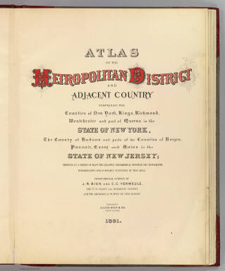
[Bien, Joseph Rudolf, Vermeule, C. C. (Cornelius Clarkson), 1858-1950]
Full Title
(Title Page to) Atlas of the Metropolitan District and adjacent country comprising the counties of New York, Kings, Richmond, Westchester and part of Queens in the state of New York, the County of Hudson and parts of the counties of Bergen, Passaic, Essex and Union in the state of New Jersey ... From original surveys by J.R. Bien and C.C. Vermeule, the U.S. Coast and Geodetic Survey and the Geological Survey of New Jersey. Published by Julius Bien & Co. New York. 1891.
Publisher
Julius Bien
Author
Western Rail Road Corporation
Full Title
Route of the Western railroad. West of Connecticut River. 1837. Enlarged from map of the state. T. Moore's Lith. Boston. (to accompany) Reports of The Engineers of the Western Railroad Corporation.
Publisher
Merriam, Wood and Co.
Author
Western Rail Road Corporation
Full Title
Route of the Western railroad. East of Connecticut River. 1837. Enlarged from map of the state. T. Moore's Lith. Boston. (to accompany) Reports of The Engineers of the Western Railroad Corporation.
Publisher
Merriam, Wood and Co.
Author
Tanner, Henry S.
Full Title
A new map of New York with its canals, roads & distances from place to place along the stage and streams-boat routes. Published by H. S. tanner, Philadelphia. Engraved by W. Brose, Philadelphia. Entered ... 1840, by T.R. Tanner ... Pennsylvania. (inset) Profile of the Erie Canal.
Publisher
T.R. Tanner & J. Disturnell
Author
Tanner, Henry S.
Full Title
Profile of the Erie Canal N.Y. ; Profile of the Ohio Canal ; Profile of the Chesapeake & Ohio Canal. (with inset profile) Baltimore & Ohio railroad. (to accompany) A Description of the Canals and Railroads of the United States.
Publisher
T.R. Tanner & J. Disturnell
Author
Johnson, A.J.
Full Title
Johnson's New York By Johnson & Browning. No. 21.
Publisher
Johnson and Browning
Author
[Adams, D. P., Blunt, Edmund M. (Edmund March), 1770-1862]
Full Title
The harbour of New York surveyed by Edmund Blunt. (with) Entrance fo the Chesapeake Bay, reduced from the surveys made by D.P. Adams and others by order of the Navy Commissioners of the U.S. by E. Blunt. (with) Views of land between Cape Henlopen and Cape Charles. (insets on 1st sheet of : The coast of the United States of North America; from New York to St. Augustine drawn and regulated according the the latest surveys and astronomical observations by Edmund Blunt). New York: published and sold by E. & G.W. Blunt, 154 Water Street cor. of Maiden Lane. Engraved & printed by W. Hooker, 202 Water Street, New York, 1827.
Publisher
E. & G.W. Blunt.
Author
Beers, D.G.
Full Title
Plan of the State of New York. Drawn and Engraved especially for this Atlas.
Publisher
D.G. Beers & Co.
Author
Beers, Frederick W.
Full Title
Map of New York and Vicinity Accompanying Atlas of New York and Vicinity, Published by Beers, Ellis & Soule, 95 Maiden Lane, New York.
Publisher
Beers, Ellis & Soule
Author
National Map Company
Full Title
New York. (Copyrighted by) National Map Company, Indianapolis. (to accompany) Official Paved Road and Commercial Survey of the United States. (inset maps) City of Greater New York ; Long Island.
Publisher
National Map Company
Author
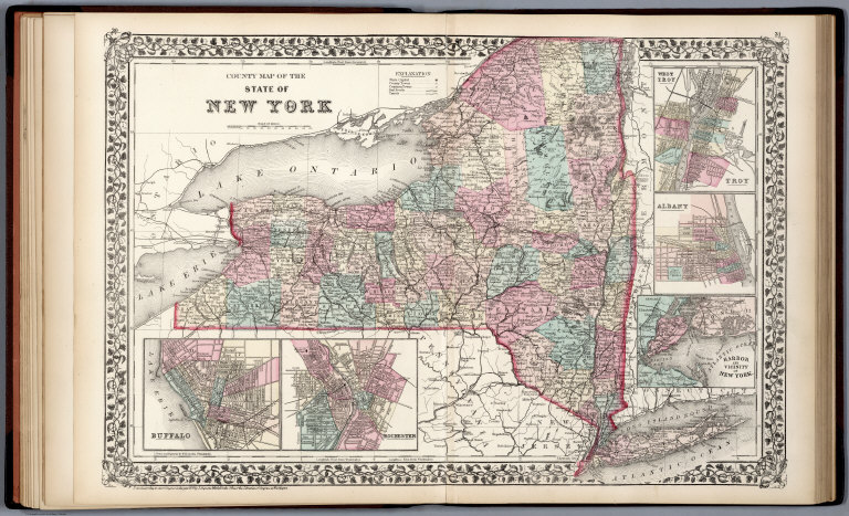
Mitchell, Samuel Augustus Jr.
Full Title
County map of the State of New York. (with five inset maps) Troy. 19. Albany. 20. Harbor and Vicinity of New York. 21. Buffalo. 22. Rochester. Drawn and Engraved by W.H. Gamble Philadelphia. Entered ... 1867 by S. Augustus Mitchell, Jr. ... Pennsylvania.
Publisher
S.A. Mitchell Jr.
Author
Mitchell, Samuel Augustus Jr.
Full Title
Plan of New York &c. Entered ... 1867 by S. Augustus Mitchell, Jr. ... Pennsylvania.
Publisher
S.A. Mitchell Jr.
Author
[Hinton, Isaac Taylor, 1799-1847, Simpkin & Marshall]
Full Title
New England and New York in 1697. From the "Magnalia americana." London: Published Nov. 1, 1830 by I.T. Hinton & Simpkin & Marshall. Engraved & printed by Fenner Sears & Co. (1832)
Publisher
[Simpkin & Marshall, Thomas Wardle]
Author
[Hinton, Isaac Taylor, 1799-1847, Simpkin & Marshall]
Full Title
Map of the state of New York, with part of Upper Canada. (with) New York (City). London: Published April 1, 1831 by I.T. Hinton and Simpkin and Marshall. Engraved and printed by Fenner Sears & Co. (1832)
Publisher
[Simpkin & Marshall, Thomas Wardle]
Author
[Johnston, Alexander Keith, 1804-1871, Rogers, Henry Darwin]
Full Title
New York and its Environs. London ... & according to an act of Congress ... 1857, by H.D. Rogers ... Massachusetts. London, John Murray, Albemarle Street, Edinburgh, W. & A.K. Johnston. Engraved by W. & A.K. Johnston, Edinburgh.
Publisher
Edward Stanford
Author
Arrowsmith, John
Full Title
Upper Canada &c. By J. Arrowsmith. (Map) 41. London, Pubd. 15 Feby. 1842, by J. Arrowsmith, 10 Soho Square.
Publisher
John Arrowsmith
Author
Cornell, S. S. (Sarah S.)
Full Title
Principal cities of the United States. Entered ... 1856, by S.S. Cornell ... Southern District of New York. Geo. Rae Smith, engraver, N.Y. New York: D. Appleton & Co., 443 & 445 Broadway. (1864)
Publisher
Appleton & Co.
Author
[Fitch, George W., Ufford, Fannie]
Full Title
State of (to be filled in). Drawn by (to be filled in. By George W. Fitch. New York: Sheldon, Blakeman and Company, 115 Nassau Street. Entered ... 1850, by Huntington and Savage ... New York)
Publisher
Blakeman, Sheldon & Co.
Author
[Beers, F. W. (Frederick W.), Watson & Co. (New York, N.Y.)]
Full Title
Portion of Yonkers and 24th ward. Portion of Bergen County, N.J. Copyrighted, 1891, by Watson & Co.
Publisher
Watson & Co.
Author
[Beers, F. W. (Frederick W.), Watson & Co. (New York, N.Y.)]
Full Title
Portion of Bergen County, N.J. Portion of city of Yonkers and Westchester County. Copyrighted, 1891, by Watson & Co.
Publisher
Watson & Co.
Author
[Beers, F. W. (Frederick W.), Watson & Co. (New York, N.Y.)]
Full Title
Plan of southern part of the city of Yonkers. Copyrighted, 1891, by Watson & Co.
Publisher
Watson & Co.
Author
[Beers, F. W. (Frederick W.), Watson & Co. (New York, N.Y.)]
Full Title
Plan of Hastings, northern part of Yonkers. Copyrighted, 1891, by Watson & Co.
Publisher
Watson & Co.
Author
[Beers, F. W. (Frederick W.), Watson & Co. (New York, N.Y.)]
Full Title
Portion of Rockland County. Portion of Westchester County. Copyrighted, 1891, by Watson & Co.
Publisher
Watson & Co.
Author
Eddy, John H.
Full Title
Map Of The Country Thirty Miles Round the City of New York. Designed & Drawn by I.H. Eddy of N. York, 1812. To Dewitt Clinton Esqr. Mayor of the City of New York This Map is inscribed by his respectful friend The Author. Published by Prior & Dunning, Map & Chart sellers No. 111 Water Street. Copy Right secured according to Law. Engrd. by P. Maverick, Newark, N. Jersey.
Publisher
Prior & Dunning, Map & Chart sellers
Author
Thomson, John
Full Title
Northern provinces of the United States. (with view) The Great Falls of Niagara. Hewitt sc., Grafton Str. E(a)st, Tottenham Ct. Rd. Drawn & engraved for Thomson's New general atlas, 1817.
Publisher
[Baldwin, Cradock, and Joy, John Cumming, John Thomson]
Author
Beers, F. W. (Frederick W.)
Full Title
(Covers to) Atlas of the Hudson River Valley from New York City to Troy, including a section of about 8 miles in width. Published by Watson & Co., 278 Pearl Street and 36 Vesey Street, New York. Compiled from official records and careful surveys, under the supervision of F.W. Beers, C.E., 1891. Copyright 1891, by Watson & Co.
Publisher
Watson & Co.
|